Quantcast
Channel: Written In Stone...seen through my lens
Viewing all 101 articles
Browse latest View live

The Adirondack Mountains of New York State: Part IV - Climbing the Geology of a Fault-Bounded Valley

$
0
0
This is post IV of my four-part series on the geology of the Adirondack Mountains. Please visit:
Part I – What's so unique about their geology?
Part II – What do we know about their geological evolution?
Part III - Climbing the Geology of the High Peaks


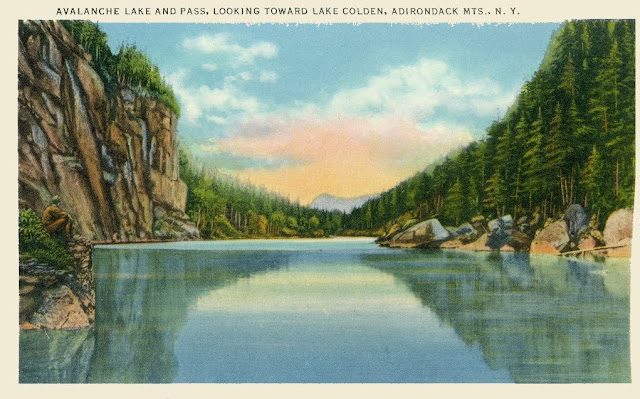
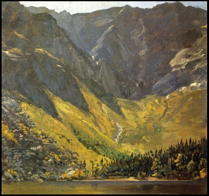
This early 1900's postcard depicts Lake Colden from Avalanche Pass in the High Peaks Region of the Adirondacks of northern New York State. Lake Colden is the first of three spillover-lakes that reside in a post-Pleistocene, glacially-scoured, fault-bounded valley between sheer cliffs of Middle Proterozoic Grenville metanorthosite.
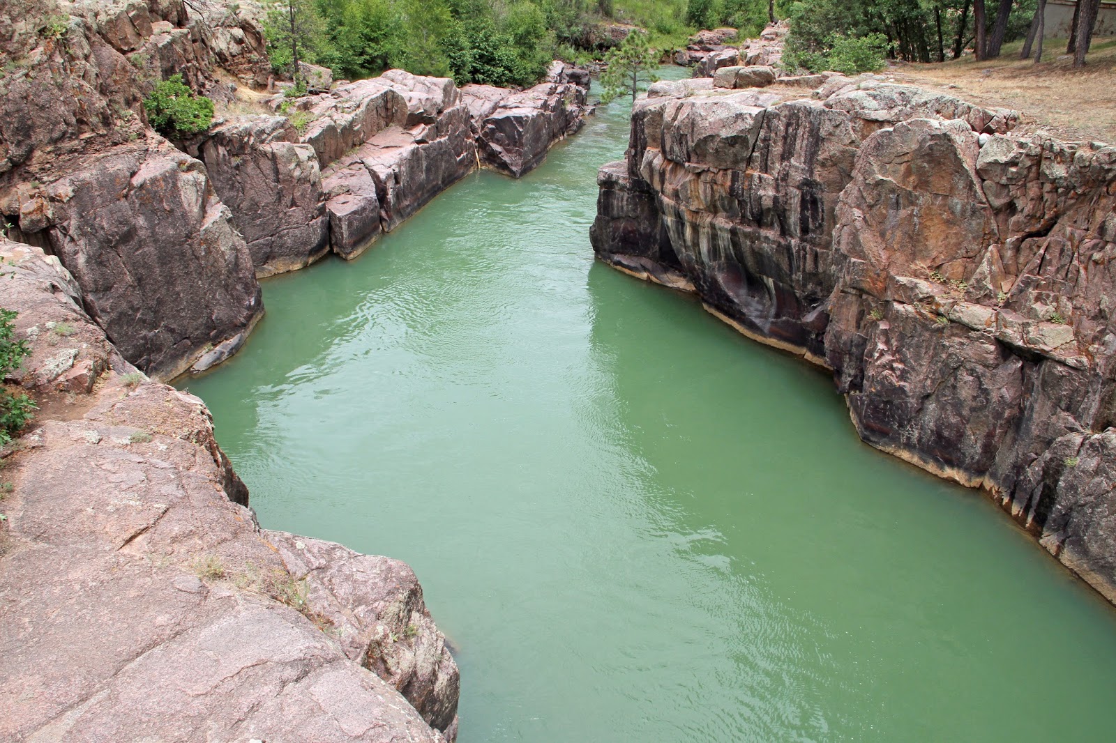


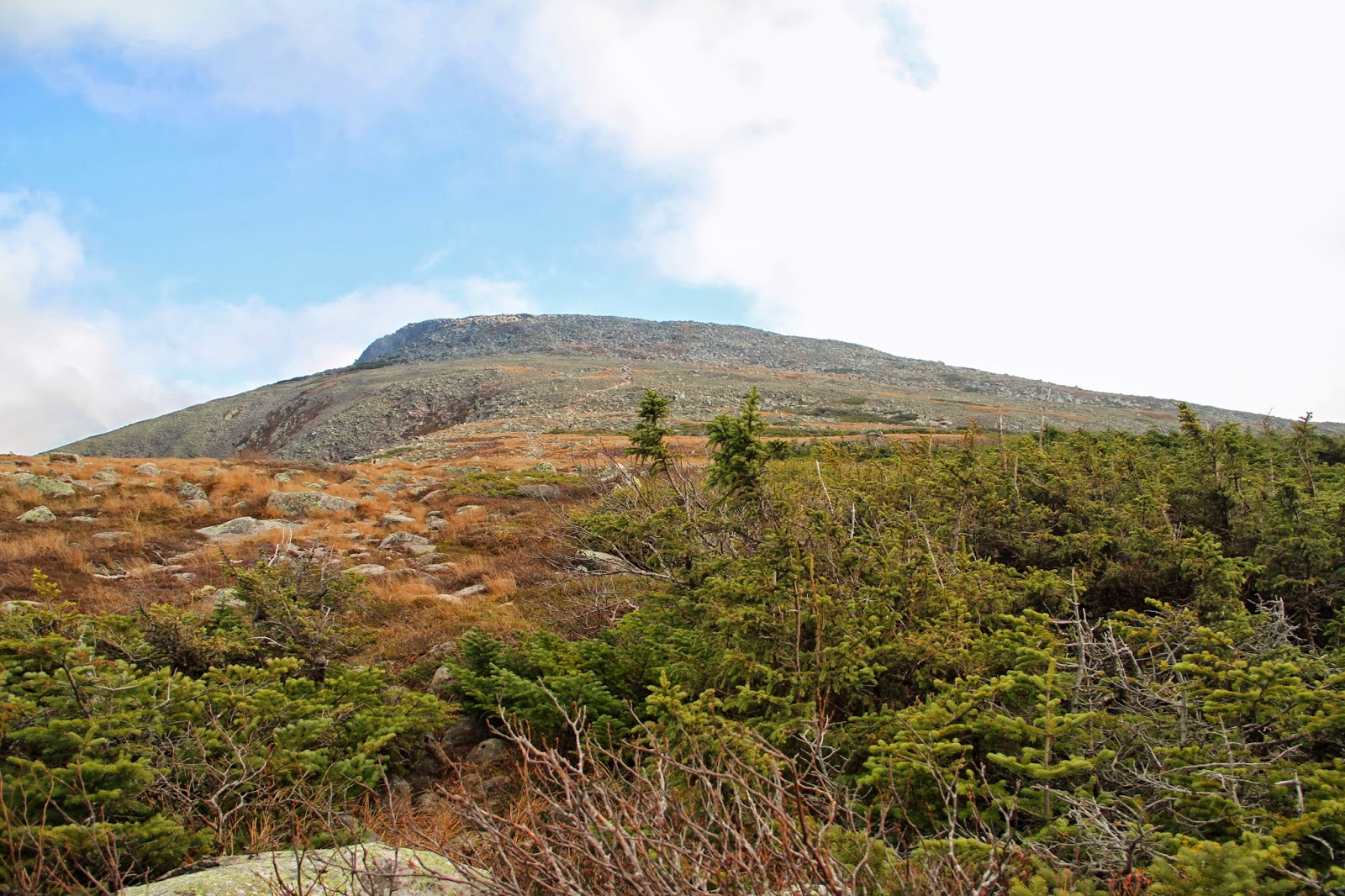
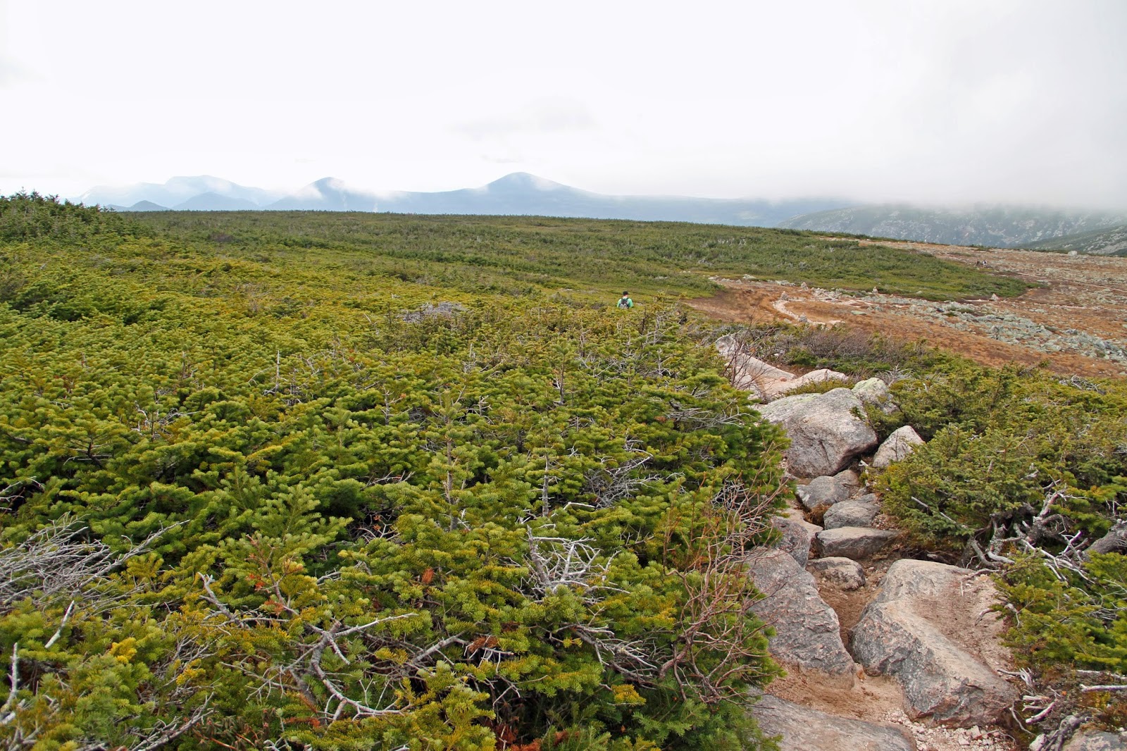
On the first day of our geological exploration in the High Peaks Region, my daughter and I ascended Mount Wright and Mount Algonquin, the latter being the highest peak in the MacIntyre Range and second highest in the state. To visit that post, click here. On this day, we explored the waterforms immediately east of the MacIntyres.

 
FINDING FAULT
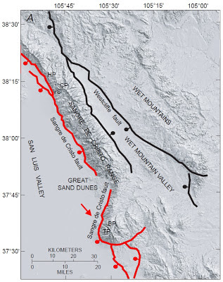
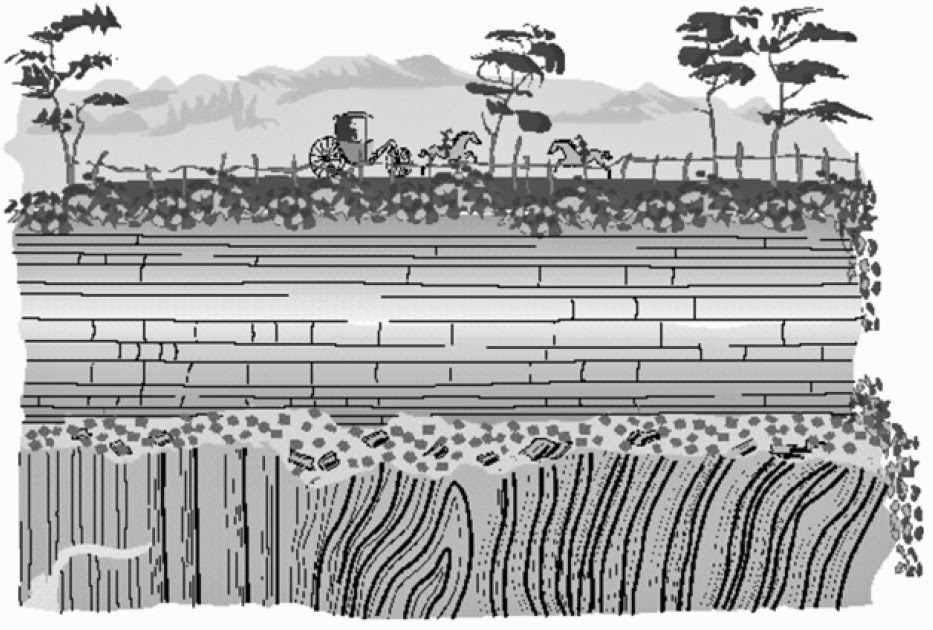
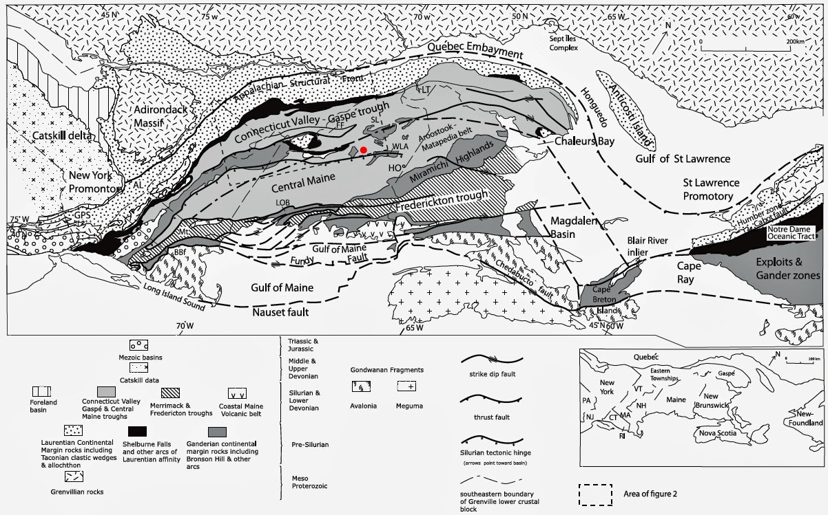
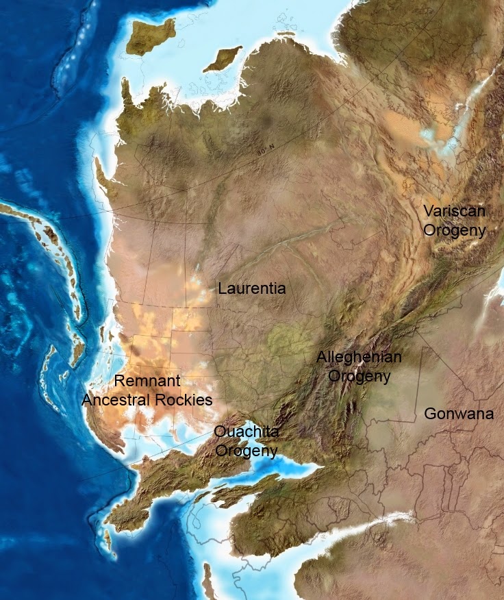
During the assembly of the supercontinent of Rodinia, Middle Proterozoic Grenville orogenic events laid a foundation of metanorthosite and associated rocks throughout the region. Many of the NE-striking faults within that basement may have begun as normal faults in the extensional environment that existed during the closing stages of the orogeny.
 
The faults that persisted within the Adirondacks were likely reactivated (and new ones created) during Paleozoic Alleghenian tectonic collisions, specifically during overthrusting of the Taconic Orogeny. Late Cretaceous thermal doming of the region of the future Adirondacks subsequent to passage over the Great Meteor hotspot also may have reactivated the faults. These events, from the Middle Proterozoic through the present, are explained in greater detail in my post Part II here. Today, the myriad of NE-SW faults influence the orientation of many of the ranges and waterways within the High Peaks Region.  

 
THE BIG PICTURE
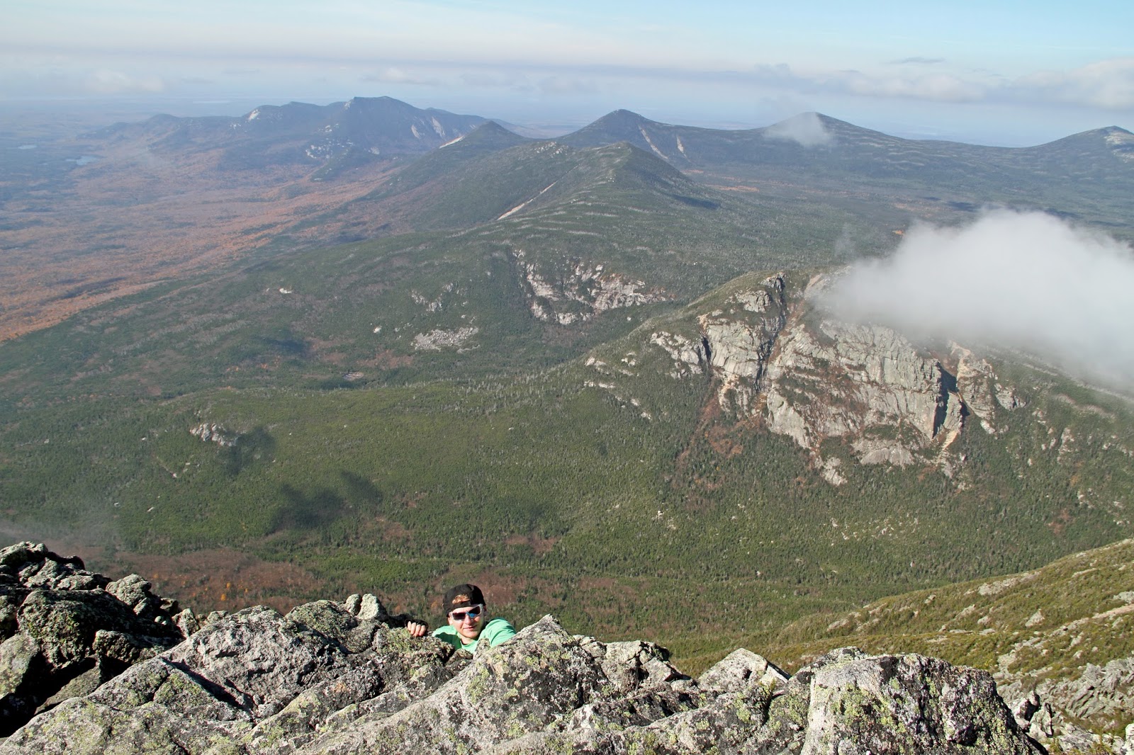
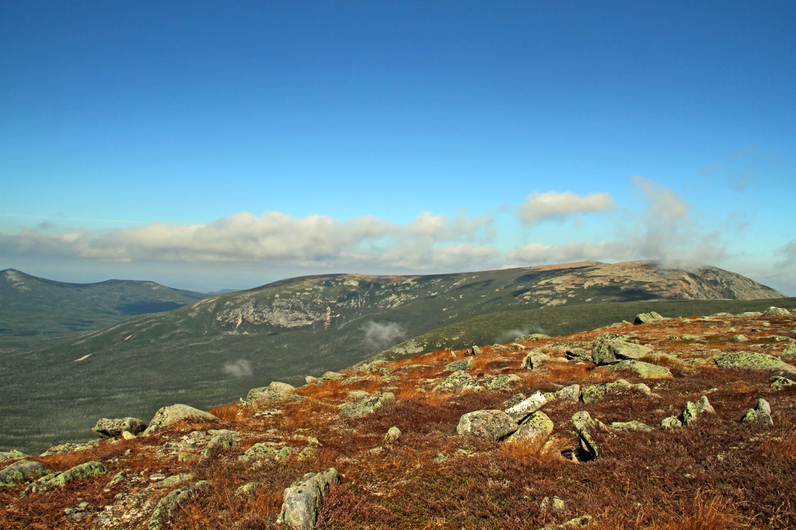
The following three-photo panorama faces south towards the High Peaks. It shows the relationship of the NE-trending MacIntyre Range to fault-bounded Avalanche Pass on the east and Indian Pass on the west. The open flat in the foreground is a small portion of a post-glacial, dry lakebed called South Meadows. Many large lakes such as this were
breached when their ice and morainal dams catastrophically broke open. Our trek to the lakes via Avalanche Pass began at Heart Lake, at the base of Mount Jo. 


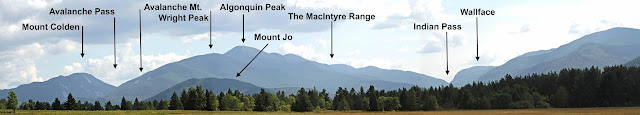
You can also see the fault-trending relationships aerially on this image captured from Google Earth.  


ASCENT TO MARCY DAM AND POND 
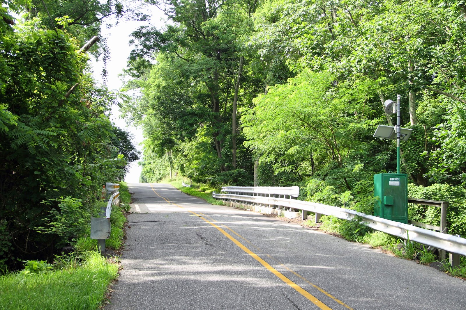
At sunrise, we departed from the Adirondack Loj (spelled correctly) at Heart Lake (elevation 2,169 feet). After a two-mile upward grade, we reached Marcy Dam and its impounded Marcy Pond (elevation 2,346 feet). In 1999 Hurricane Irene wiped out a footbridge that crossed the dam, which was rebuilt downstream across Marcy Brook. The dam replaces one first built for the logging industry at the turn of the previous century.


A wooden, weather-beaten Marcy Dam without its footbridge impounds brook trout-stocked Marcy Pond at low stage.

LEGACIES OF THE PLEISTOCENE
The waters of Marcy Pond are a small part of the St. Lawrence Watershed. They flow north to Lake Champlain and the St. Lawrence River, the widest river in the world and a major shipping lane between the Great Lakes and the Atlantic Ocean. The Adirondack’s watersheds and their respective waterforms formed subsequent to the most recent recession of the Laurentide continental ice sheet in the Pleistocene about 16,000 years ago.

Late Cretaceous uplift responsible for the creation of the Adirondack range initially established a radial stream pattern in the mountainous, elliptical dome that formed. With subsequent downcutting to erosion-resistant, anorthositic bedrock, Grenville-age faults began to dictate the pattern of flow. Today, still radial on a grand-scale, a trellis pattern follows the many linear fault zones with lakes, rivers and streams directing their waters ultimately to the Atlantic either via the St. Lawrence or Hudson Rivers.

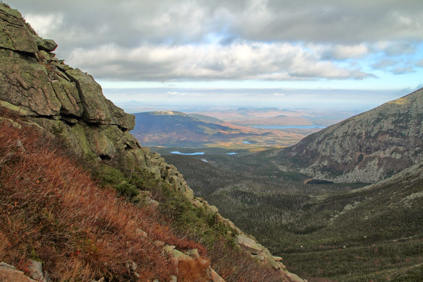
We’re standing on Marcy Dam looking south across rain-depleted mudflats of Marcy Pond. The pond serves the watershed north of Avalanche Pass which is directly ahead. Landslide-scarred Mount Colden forms the east side of the pass, but the pass divides the watershed to the north and south.


ACID RAIN
The waters of the Adirondacks are sensitive to deposition in the form of acid rain due to their topography, low neutralizing capacity of the lakes and streams, and the relatively large amounts of annual rainfall. Sulfur dioxide and nitric oxide emissions from the burning of fossils fuels not only rains down from the atmosphere as diluted acids but falls to earth in the form of particles, gases and aerosols. As a result, the quality of the water has degraded over the past century.

The situation is compounded by sulfur dioxide emissions that provide the material for the growth of bacteria which in turn convert mercury into a form that is bio-available to fish. It gets worse in that acid soils become depleted of calcium and other nutrients, and release aluminum into the surface waters. Although pollution reduction measures from Clean Air Act legislation have shown improvements, the forests and aquatic life have suffered considerably. 


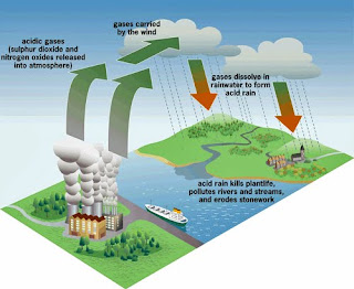
An informative paper on acid rain deposition in the Adirondacks is here.

 
MOUNTAIN STREAM DYNAMICS
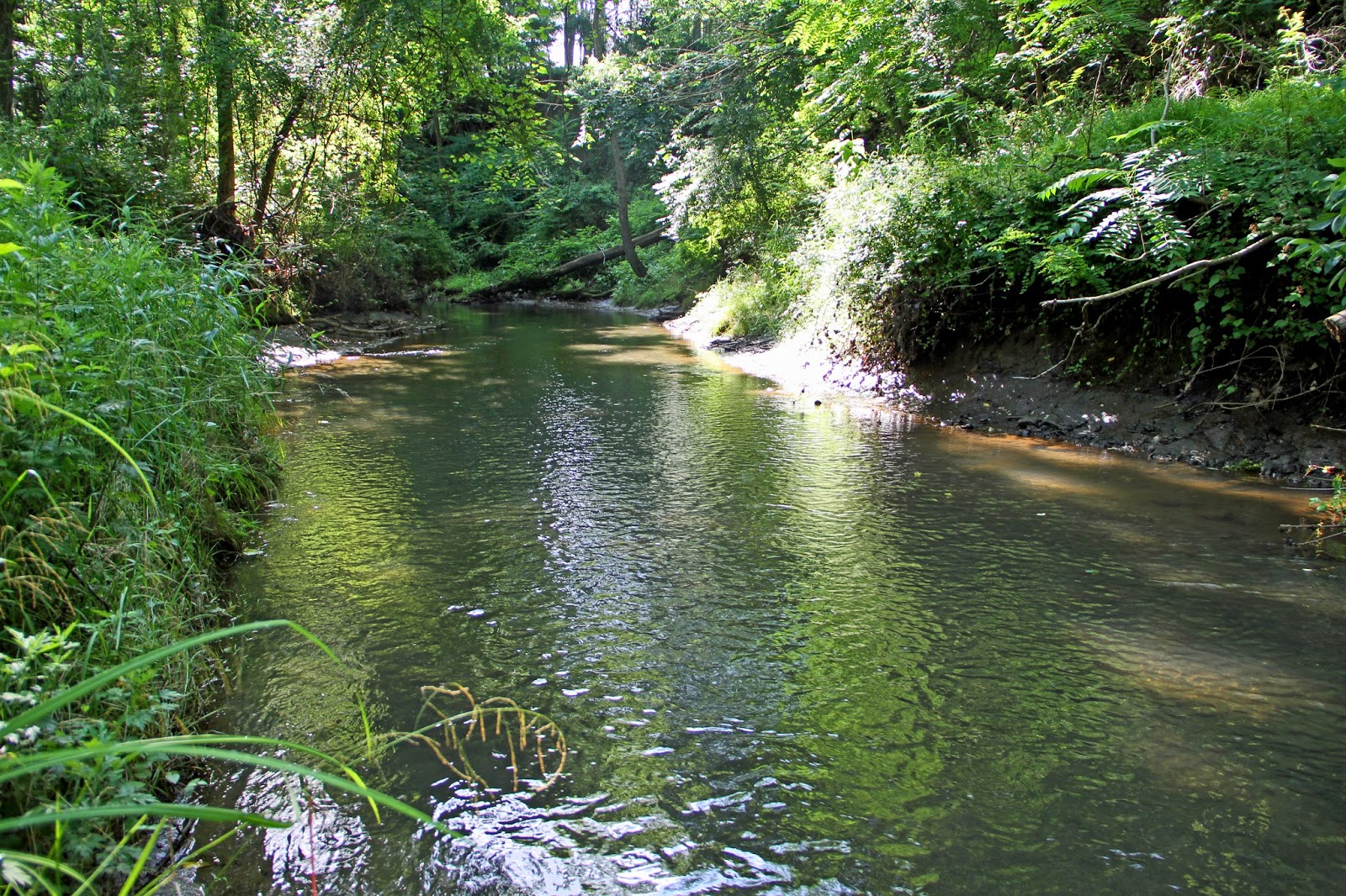
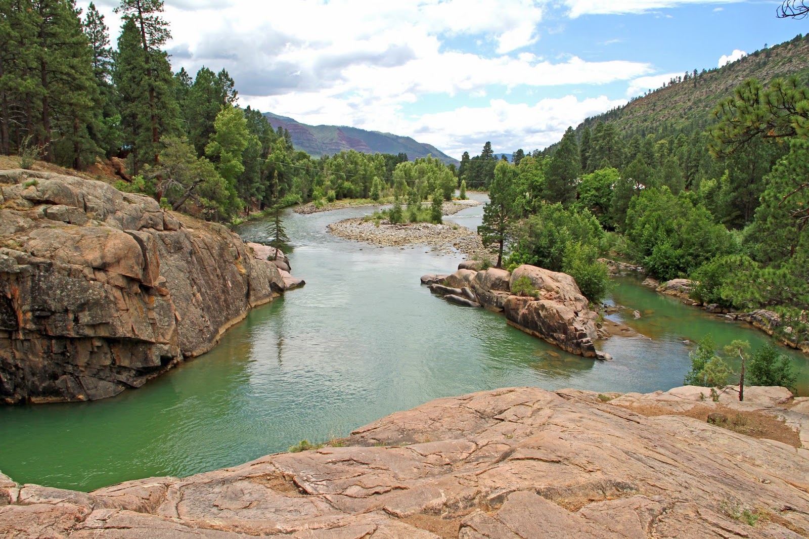
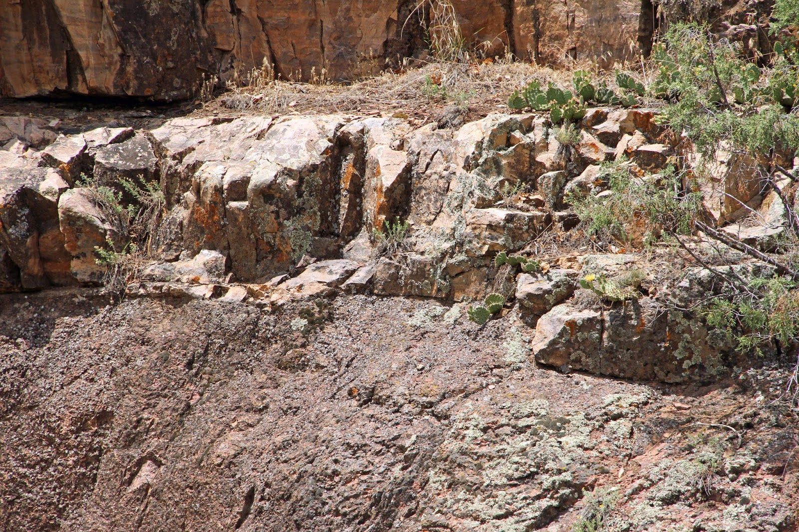
Above Marcy Pond, the trail to Avalanche Pass roughly follows Marcy Brook, again dictated by the underlying bedrock. Seen here at low-flow stage at a bend in the brook, the distribution and size of anorthositic cobbles and boulders in the streambed, and the tangled mass of vegetation hint at the high volume and velocity of water during a spring melt or severe thundershower.

In spite of its shallow gradient, notice the scouring of the banks and bed at the widest point of the channel, also the deepest. Erosion occurs at the outside of the bend (the cutbank), while slower velocities at the inside of the bend causes point-bar deposition (the slip-off slope). At low-stage and at the inside of the bend the stream lacks the power to carry its load of suspended sediment and detritus.

Physical characteristics of the stream also influence water quality, and therein, the variety and type of habitat that is available to support life. Also notice how the riparian vegetation in the bank zone is affected by the stream’s hydraulic geometry. Evergreens are thriving on the inside of the bend; whereas, mixed deciduous, herbaceous growth has colonized the outside (i.e. willows), the damper more saturated soil region. 


Viewed within the context of the geological time frame, the contribution to landscape evolution of a small stream such as Marcy Brook, which might flood only a few times a year, should never be perceived as inconsequential. Significant change occurs over geological periods of a thousand or a million years especially accounting for the many companion streams that exist within the watershed!
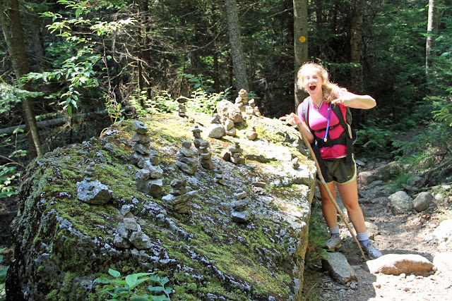
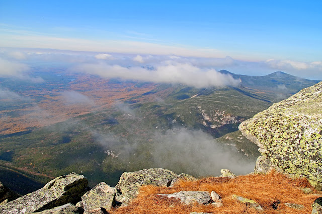
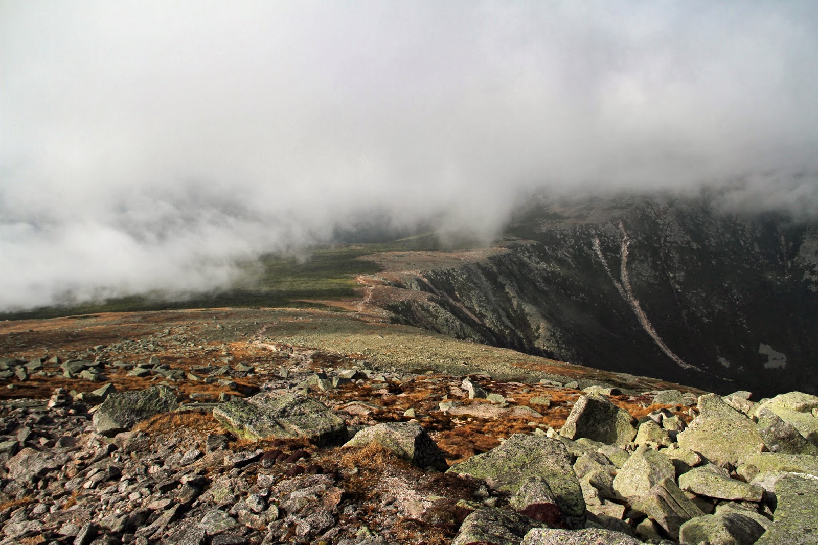
 
AVALANCHE PASS
Continuing on our ascent, we reached Avalanche Pass between the confining mountains of Colden and Avalanche. The pass serves as the drainage divide for waters flowing north to Lake Champlain and south to the Hudson River within the Upper Hudson Watershed. As we entered the pass, its lichen-encrusted, sheer rock walls of anorthosite increasingly closed in, and the wind picked up as it accelerated from the confinement.

This is the narrowest section of Avalanche Pass looking south with opposing walls of anorthosite separated by 100 feet. 


Backpackers have taken the time to construct this mini-cairn city which my daughter felt obligated to contribute to.


In keeping with its namesake, an enormous, jumbled-mass of vegetation and bedrock avalanched downslope from Hurricane Floyd in 1999 along a 600 foot-long rock slide on Mount Colden. Volunteers and professionals have industriously cleared a trail directly through it. This photo looks up the slide on Colden’s western face past the mountain of cut foliage. In winter, hikers and skiers must be attuned to the inherent dangers that lurk within the pass from avalanching snow.


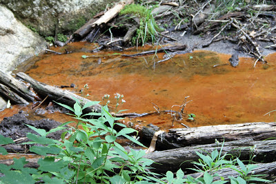
Within the pass is a spruce swamp with boardwalks over the boggy ground which supports the rare fern Dryopteris fragrans. Occasional, rust-colored stagnant pools of water suggest iron-rich pyroxenes that eroded from anorthosite underwent oxidation and imparted a dark-brown, rust color to the water.


AVALANCHE LAKE
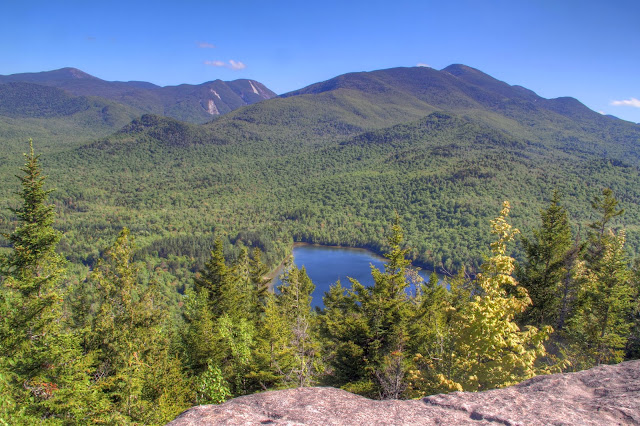
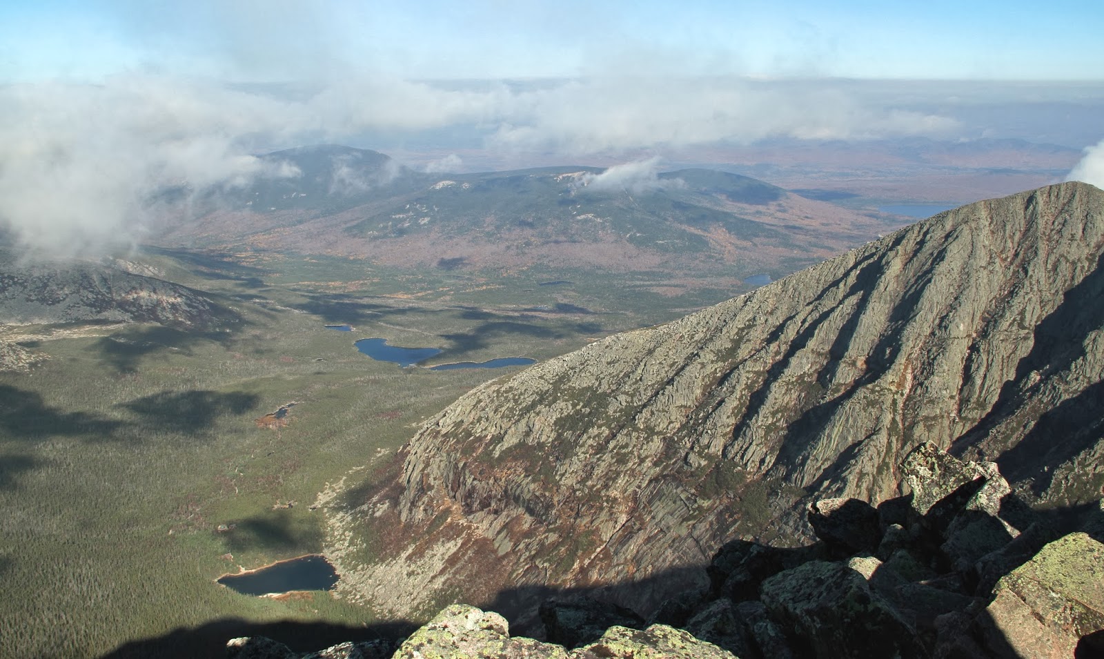
Once through the pass you emerge into the uppermost reaches of the Upper Hudson River watershed. You're about to receive a visual reward for your climbing efforts. Before you is spectacular, sparkling Avalanche Lake, the first of three spillover-lakes that lie in a chain within a fault valley. Avalanche Lake is supposedly the highest lake in the United States east of the Rocky Mountains at an elevation of 2,864 feet. I’ll let my industrious readers research that one.

This is an incredibly special and beautiful place in the High Peaks that evokes strong emotions when first seen. Framed by the precipitous mountain flanks of Colden on the east and Avalanche Mountain on the west, their rock-walls plunge directly into the lake. This view is from the beach looking south from the end of the lake. Barely visible at the far end of the lake is its outlet and an active beaver dam. 


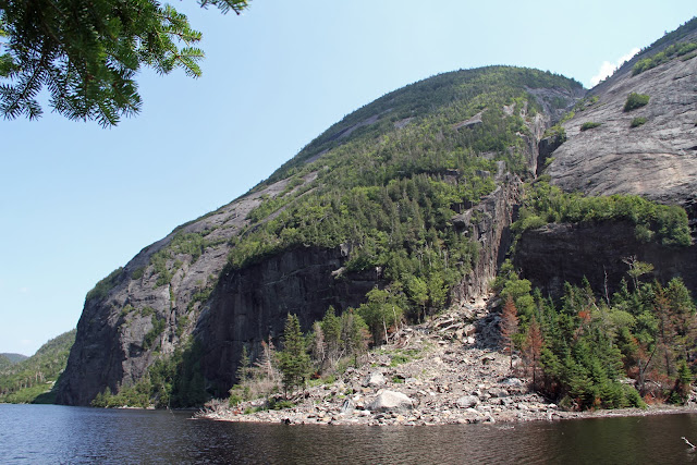
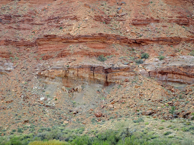
Avalanche Mountain’s vertical face plummets a thousand feet into the lake’s western side. Notice the parallel jointing on the rock wall, some of which is curvilinear, composed of metanorthosite and anorthositic gneiss. Alleghenian orogenic collisions of the Paleozoic, most likely the Taconic, are responsible for these deformational features along with the reactivation of faulting that contributed to the formation of the valley. Also notice the pattern of exfoliation in areas of the cliff with a reverse-step pattern. Anorthosite shares this property with granite by eroding from the surface in layers like an onion. Around the lake mixed conifers and deciduous hardwoods luxuriate in remnants of glacial till, a mixture of clay, sand, silt and stone.


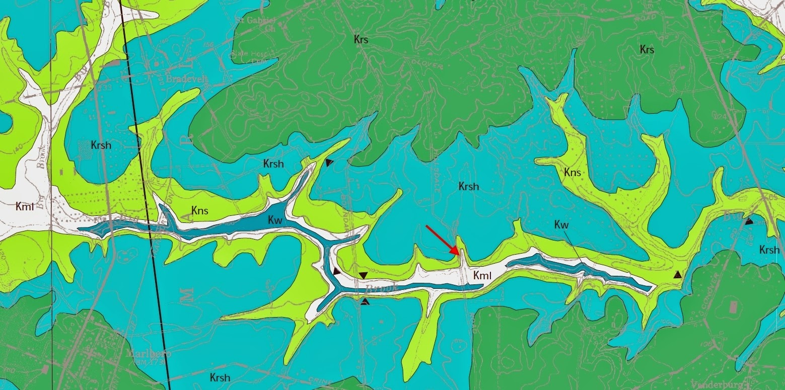
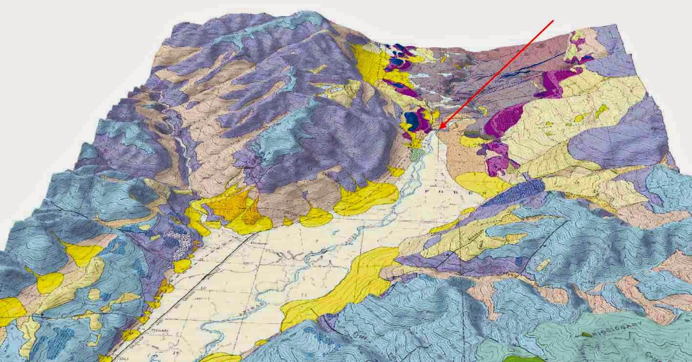
The following USGS topographic map illustrates the NE-trending fault-valley that contains the lakes of Avalanche, Colden and Flowed Lands (not seen), all south of Avalanche Pass. The closeness of the contour lines on Avalanche Mountain’s eastern face reflects its thousand-foot verticality. Faults within the Grenville basement served to weaken the bedrock. Following Late Cretaceous uplift and unroofing, the bedrock was more readily eroded and excavated by Pleistocene Continental ice sheets that slowly bulldozed through the region.

The system of spillover lakes is a product of the post-glacial watershed that was established. Surface water elevations are primarily controlled by the underlying bedrock elevation rather than the type of bedrock. As mentioned, a trellis drainage pattern has developed in response to the system of faults and is superimposed upon an outward-from-the-center radial pattern dictated by the Adirondack’s uplifted dome (see my post Part I here).  


LAKE COLDEN AND AVALANCHE PASS FROM THE SOUTH
From the trail along the lake's western shore, this two-photo panorama looks back to the north at Avalanche Pass and its defining and confining cliffs of Avalanche Mountain and Mount Colden on the west and east, respectively. The lake is also notorious for its double echo at this spot which we tested successfully.


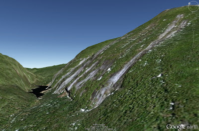
This Goggle Earth, northeast-facing, aerial-view of the fault helps to illustrate the orientation of Avalanche Pass and Lake to Avalanche Mountain on the west and Mount Colden on the east. Shear displacement along the fault on the western side is to the southwest. Notice the rock slides that have scarred the slopes of Mount Colden. Also notice the outlet-brook that flows from the lake's south end toward Lake Colden.


“HITCH-UP MATILDA!”
The trail south continues along the west side of the lake, but it’s nothing like you might expect. In two stretches where the cliff plummets straight into the lake the only way to construct a trail in the 1920’s was to bolt two, wooden catwalks to Avalanche Mountain’s rock-face. And that’s not all. Over a dozen wooden boardwalks and ladders lead you up, over and around massive boulders that have torn loose from above and littered the shoreline. It reminded me of the board game Chutes and Ladders from my youth.

As the 1868 story goes, a young woman named Matilda was being carried by a guide through the pass. As the water deepened, her sister repeatedly urged Matilda to “Hitch-up!” in order to remain dry. Such is the mountain lore of the Adirondacks.


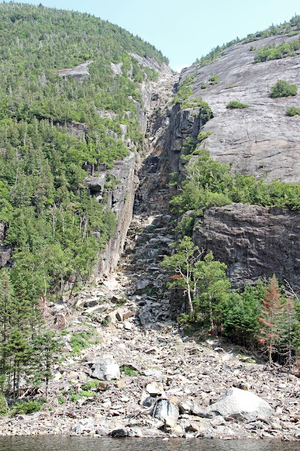
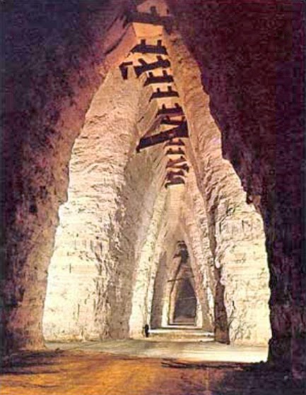
THE TRAP DIKE OF COLDEN
Another surprise awaits the climber! Halfway down the lake on Hitch-up Matilda, Mount Colden’s famous and infamous “Trap Dike” comes into view across the lake. Dikes are conduits that transport molten, pressurized magma through fractures and weaknesses in the crust. Being less resistant to erosion than the anorthositic country rock through which it intruded, the dike has since weathered out upon its exhumation and exposure, leaving the gaping chasm that we see today. 
 
The dike appears as a deep, 80 foot-wide, vertical gash that extends from the lake to Colden’s summit, a distance of almost 2,800 feet. The dike's immense size is very deceiving with its length being twice the height of the Empire State Building. Look at the massive evergreens for scale. 


Although many hikers believe that you become ‘trapped’ once you enter the dike (which has some truth historically), the word is actually Swedish for stairs (trappa) referring to the “steps” that formed in the dike’s magma as it cooled and contracted. Geologically referred to as the Avalanche Dike, it was first explored by pioneering geologist Ebenezer Emmons in 1836 who described the experience of being within its vertical walls as of a "sublime grandeur.” Ebenezer made this sketch of "The Great Trap Dyke at Avalanche Lake" in 1883. 


DEFINING THE DIKE GEOLOGICALLY
Compositionally, the Trap Dike is a diabase of garnetiferrous metagabbro. The presence of garnet within the dike is a signature of high grade, granulite-facies metamorphism, and suggests that it intruded before the final metamorphic tectonic event to affect the Central Highlands Region.

The dike emplaced before anorthosite host-rock crystallization based on such characteristics such as sharp contacts with the anorthosite and its cross-cutting relationship. Its intrusion and metamorphism occurred during the protracted Grenville Orogeny, a billion years before the uplift of the Adirondacks into a mountain range in the Late Cretaceous. 

Although the Grenville Orogen was extremely complex, highly protracted and multi-phasic, for purposes of simplicity it can be subdivided into four major events: a subduction arc-collision, an episode of voluminous anorthosite and AMCG intrusion, a strong collisional event and an extensionally-dominated collapse of the orogen. The Trap Dike's gabbroic rock likely would have formed during anorthosite petrogenesis and its intrusion shortly after the host-anorthosite emplaced. For more information on anorthosite evolution, please visit my post Part III here.


A CLUE TO THE REGIONAL LANDFORM
The rock-type on opposite sides of Avalanche Pass is anorthosite, suggesting that the landform might simply have resulted from closely-spaced joints, of which there are many. The formative clue is revealed by Colden's Trap Dike which continues on the opposing side of the valley across the lake. Offset of the two dike-segments on either side confirms the landform is indeed a fault-valley, as is Indian Pass on the west of the MacIntyre Range between it and Wallface.

 
ROCK SLIDES OF COLDEN
Also of interest are the bare rock surfaces on Colden’s granite-like face. They are in fact landslide scars and are typical of many high peaks in the Adirondacks. The thin cover of soil that tentatively clings to the anorthosite 's rough surface is stabilized by vegetation but can become destabilized on steep slopes when saturated by heavy, unrelenting rains.

The Trap Dike serves as a natural funnel for runoff and slide material by channeling everything down to the lake. At the dike’s outlet a large debris fan extends out into the lake. So massive was the debris-flow from Hurricane Floyd in 1999 that it instantly raised the height of the lake ten feet, and in 2007 an avalanche on Colden blasted debris to the opposite shore. Historically, the earliest documented slides are from the hurricanes of 1869 and 1942.


This view of Colden’s west face was taken from Mount Algonquin on our climb the previous day. Old slides are distinguished from new by the color of freshly exposed plagioclase gleaming in the sunlight. The slides' funneling of material into the dike have deforested its lower half. The dike's vegetated upper portion appears as a depression and continues over the crest of Colden and beyond, as seen on the topo map (above). Remember that the dike continues to the west as well into the body of Avalanche Mountain, offset by faulting regionally. A second, smaller dike also has been found on Colden near its summit parallel to the foliation of the anorthosite.   


Aside from its prominence and topographic expression, Mount Colden's dike is not unique in these high peaks of the Adirondacks. For example, a billion years after the emplacement of the Trap Dike, swarms of gabbroic dikes formed during the Mesozoic rifting of the Atlantic Ocean, but they occur with greater abundance in the eastern Adirondacks, southeastern New York and throughout New England.

 
CLIMBERS BEWARE!
Since the first documented climb in 1850, the Trap Dike has become a classic and dangerous mountaineering route in the High Peaks, renowned for its steepness and difficulty especially in wet weather. It contains many large boulders and ledges to negotiate, and even a waterfall or two in the spring. Wet anorthosite, even with its rough texture, can be extremely slippery when wet.

Climbers heading for Colden's summit that bail out of the dike too early find themselves on a precipitously-steep, exposed-slope of 45º. “Stay in the dike, where the climbing becomes easier!” warn online climbing journals where the best spot to exit the dike is marked by a cairn. Overall it’s a non-technical, Class 3-4 climb, but many rescues take place when climbers get stuck or "trapped" in the dike, and many have lost their lives by literally falling off the mountain. Check out YouTube.com for climbing videos, but don't forget to look at the geology! 

 
AVALANCHE LAKE TO LAKE COLDEN
Continuing further on the trail, Avalanche Lake’s outlet at its south end provides a close look at a beaver dam and a tremendous view north toward Avalanche Pass. We’re looking directly up the fault!


Having departed from Avalanche Lake, we followed its outlet stream down to Lake Colden at an elevation of 2,766 feet. Colden is the second of three lakes in the chain within the fault-valley and the end of our journey into the High Peaks Wilderness. Beyond Lake Colden’s beaver-marsh, we’re looking north toward Colden with its rock slides. The trail continues on below Lake Colden along another outlet brook to the curiously named lake of Flowed Lands which drains south to the Hudson River and down to the Atlantic Ocean.  


Lake Colden ended our exploration of the chain of lakes within Avalanche "fault." A curious stream enters the Flowed Lands from the east called Opalescent Brook. The stream bed is renowned for its anorthosite filled with beautiful, blue-green iridescent labradorite that shimmers in the water. We were hoping to reach that point, but the trek got the best of us. The round trip was almost 12 miles and 8 hours, returning via the same route. Perhaps next summer!
 
 
"FOREVER WILD"
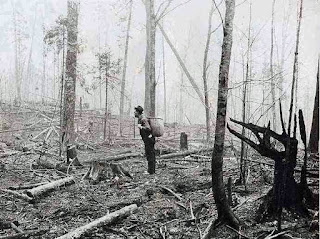
In spite of the fact that the Adirondack Park and Forest Preserve was established with the catchy phrase “Forever Wild” in 1885, the logging industry managed to denude vast areas that left the region susceptible to wildfires. In 1903 an estimated 600,000 acres of land burned in the Adirondacks including vast tracts of this High Peaks Watershed. Various conflagrations continued for an additional decade. Between rampant logging, forest fires and disruption to wildlife, much of the Adirondack wilderness laid decimated.


The Adirondack region was the "crucible of the American conservation ethic" at the turn of the twentieth century (The Great Experiment in Conservation by Porter et al, 2009). These days, tourism, timber and mining are the mainstays of the modern Adirondack economy. Yet, significant change is likely to be in the future of the Adirondacks as it continues to grapple with a shared vision of sustainability.
 
The mountains are actually wilder and more pristine now than they were a century ago. Today, the park's 2.6 million acres are heavily protected and well-managed. Its size is 6 million acres, larger than Yellowstone, Yosemite, Grand Canyon, Great Smoky and Everglades National Park COMBINED! 
 
“We do not inherit the earth from our ancestors;
We borrow it from our children.”
Native American proverb

Roadside America: Part II - Weird, Wacky, Tacky and Wonderful

$
0
0
Virtually every geology-based road trip I've been on has had its share of unforgettable side-trips, off-beat detours and unplanned turn-offs. Many of them weren't on the map and couldn’t be found again if you tried. The best part, second to the geology, was the adventure of the unexpected and the inexplicable waiting at every turn.

That’s when you see the unusual signage, the eccentric pieces of art, the unique architecture, the kitschy sculptures, the cheesey tourist attractions, the poignant juxtapositions, and all the wacky, tacky, bizarre and oddball attractions that are so characteristic of America.

Here are some examples on the lighter-side of what I’ve seen along the geology-road from here to there in this Part II of a work-in-progress. Click here to see Part I. Every photo was taken last summer while cruising the Colorado Plateau in New Mexico and Colorado with my friend and geology mentor, Wayne Ranney


In the northwestern corner of New Mexico, the image of the Shiprock diatreme in the distance was replicated in the architecture of Shiprock High School seen in this juxtaposition.


Even McDonalds in the town of Shiprock has gotten into the act.


An electrifying juxtaposition. 


This poignant, Cherokee-inspired, metallic sculpture on the Navajo Reservation decorated the roadside on the outskirts of the town of Shiprock, New Mexico


A bovine lawn ornament in Mancos, Colorado, the pink flamingo of the 50's 


“Nothing Satisfies Like Beef” sign on a livestock barn 
between Mancos and Durango, Colorado 


Outside Durango, this fantastic antler-archway decorates the walkway to a store. 


Outhouse near Baker’s Bridge, Colorado. Occupancy limited to one. 


This rusty 1950’s Art Deco, Crosley Shelvador refrigerator was keeping
the outhouse company. You can actually buy one on ebay for big bucks. 


We’re peering into the past at the wide, unpaved boulevard of Blair Street in the mining town of Silverton, Colorado. The town was established in 1874 in the wake of the Gold Rush of 1860 in the San Juan Mountains. The entire town is designated a National Historic Landmark. Although appearing like an average street out west, it’s actually the notorious side of town where prostitution, saloons, dance halls, gambling and robbery were prevalent back in the day. In fact, over half of the town’s forty saloons and brothels are still standing. An imaginary line down Greene Street through the center of town separated Blair Street from the respectable side of town where law-abiding, church-going residents lived. Mining in Silverton closed down in the early 1990’s, but you can be sure there’s still gold in “them thar hills.”
Silverton, Colorado  


One room schoolhouse in Malachite, Colorado, for sale. “Own a piece of history” with 36 acres off the main highway "for privacy and quiet" for $90,000. Cheap! 


"No Fishing” sign on Royal Gorge Bridge outside of Canon City, Colorado.
At 856 feet above the Arkansas River, that’s one long line cast!
Check out the great geology of this funky tourist trap on Wayne Ranney's post here


There’s no better multi-tasker than a geologist. They’re actually trained in school to careen their necks at roadcuts while flying down the highway at breakneck speeds. This geologist (who shall remain nameless) obviously graduated at the top of the class.


This lifelike mural was on the side of a brick building in Delta, Colorado,
and perfectly blended in with the landscape.


Custom shop for the rehab of vintage cars and trucks. Limit one per customer.
Delta, Colorado


Fantastic futuristic 1950’s motel sign in Delta, Colorado 


If there’s a Jurassic Park, there must be a Jurassic Court.
Fruita, Colorado


A stegosaurus lawn ornament
Fruita, Colorado


You’ll only see this crossing sign west of the Mississippi.
Colorado National Monument, Fruita, Colorado


Somewhere in rural Colorado, perhaps near Cortez 


So much geology. So little time. Yours truly. 
Colorado National Monument, Fruita, Colorado.

The Great Sand Dunes of Colorado: Part I - Its Geological Evolution

$
0
0
“The answer is blowin’ in the wind.”
Bob Dylan, 1962

Nestled in an embayment at the foot of the Sangre de Cristo Mountains in south-central Colorado are the tallest sand dunes in North America, rising a staggering 750 feet above the flat terrain of the San Luis Valley. Although its shifting sands rejuvenate with the whim of the wind, the eolian dunefield remains transfixed in a perfect balance between the forces of nature that created it and those that want to cast it to the wind.


Darkened by light rain and shadows of the late day sun,
the mineralogy of the dunefield’s darker sand hints at its provenance.

The Great Sand Dunes are a spectacular example of what happens when topography such as mountains becomes involved in creating a wind-generated landform. When transported southwesterly-sand runs into the towering obstacle of the Sangre de Cristo’s, the shapes of the dunes within the field become more complex. Swirling northeasterly storm winds create a myriad of “complicated, merging ever-changing dune types” resulting in a “landscape of staggering complexity and beauty.” (Sand by Welland, 2009)


“Their appearance was exactly that of the sea in a storm, except as to color."
Zebulon Pike of the Lewis and Clark Expedition
First written account of the Great Sand Dunes in 1807

THE SAN LUIS VALLEY
In July, my colleague, geologist Wayne Ranney and I left the rugged San Juan Mountains in southwestern Colorado and headed east across the variably sun-parched and irrigation-quenched San Luis Valley. Our destination was Great Sand Dunes National Park and Preserve on the windward side of the Sangre de Cristo Mountains 65 miles to the east.


The intermontane valley resides within the embrace of the two mountain ranges, both of which belong to the Southern Rocky Mountains. Its a landscape of many contrasts. Vast dry regions with sparse, scrubby vegetation and alkali flats neighbor areas with saturated ground, thriving wetlands and lush crops, while ephemeral disappearing streams encircle vast sand dunes. The valley possesses both the driest and wettest parts of Colorado at the same time. Lying at an average altitude of 7,664 feet, it’s considered an arid high desert since it receives less than seven inches of rainfall a year.


But driving across its center, you wouldn’t suspect it. The valley is irrigated by a combination of surface water directed into a 150-mile system of canals and laterals, and by a rotating, mechanical army of pivot sprinklers fed by ten thousand artesian wells fed from aquifers located above and below a non-porous “Blue Clay Layer”, many at a mere 12 feet below the surface. The aquifers are replenished along the mountain fronts where water seeps into the recharge zone. The valley’s main crops include alfalfa, hay and potatoes, the United States’ second largest producer. 


The San Luis Valley reminded me of the Imperial Valley in southern California, another arid region that combines water and sun into an agricultural oasis. Along with aquifers on the contemporary landscape, the Rio Grande and the other rivers that emanate from the mountain fronts flanking the valley have been the vital lifeline for civilization for thousands of years, just as it is today.


Approaching from the west, from a distance the dunes appear hazy and hauntingly mirage-like against the backdrop of the high peaks of the Sangre de Cristo’s. Early Native American travelers through the region, and later Spanish explorers, adventurous homesteaders, ranchers and farmers undoubtedly used the recognizable dunefield as a landmark, as did we. In fact, a network of ancient trails, the Los Caminos Antiguos, lives on as the modern highway on which we were driving.


A GEOLOGICAL SYSTEM IN PERFECT EQUILIBRIUM
The Great Sand Dunes geological system consists of four primary components: the dunefield (tucked into a mountain alcove); the sand sheet (the largest component of the system and the primary source of sand); the Sangre de Cristo Mountains (with its watershed and windshed); and the sabkha (to the west and south of the field where sand is seasonally saturated by rising ground water). The formation and preservation of the Great Sand Dunes is contingent on a unique balance that exists amongst its components.


From Valdez et al, 2006

THE SABKHA
In areas where the sand is seasonally saturated by rising ground water, a sabkha or salt-encrusted plain has developed, an Arabic landform. The geologic definition actually refers to a coastal setting characterized by evaporites and eolian deposits, but its usage is appropriate in this similar environment. In late summer when the water evaporates away, the dessicated minerals cement sand grains together forming a white crust of sodium carbonate, calcite and other evaporites. Early settlers collected the crust to use in baking or laundry detergent.


In this northeasterly Google Earth view, Great Sand Dunes rests against a backdrop of the Sangre de Cristo’s windward slope. Surrounded by the sand sheet, the fluctuating watertable and intermittent system of streams feed the ephemeral lakes and wetlands of the sabkha. Low-lying sabkha wetlands support a diverse ecosystem of shore and migratory birds, insects and reptiles. 


THE SAND SHEET
Having nearly crossed the San Luis Valley, we’re looking back towards the distant San Juan Mountains. The verdant farmland we travelled through has become a dessicated, featureless plain called the “sand sheet.” We’re seeing it in its unirrigated, natural state. The natural vegetation consists mainly of phreatophytes and xerophytes, resistant plants that send water-seeking roots deep into the soil and plants that can tolerate dryness, respectively. The names of the plants sound just as hardy: greasewood, saltgrass, rabbitbrush and sagebrush.


The deepest portions of the sand sheet are thought to be the remnant of an ancient lake called Lake Alamosa, while its surface is wind-blown sand that is gradually moving toward the Great Sand Dunes, a vital clue to the dunefield’s genesis and replenishment.


Just south of the Great Sand Dunes, we’re standing on the edge of the sand sheet (red arrow on the map below shows the perspective of view), now a more dense grassland, and facing the Sangre de Cristo Mountain Range; the Culebra Range reaches to the south. Blanca Peak is the angular mountain hiding in the back, the fourth highest summit of the Rockies at 14,345 feet. Its namesake is derived from its light-colored, metamorphosed-Precambrian gneiss, which was driven upward as a crustal block along with the rest of the range.

Indicative of mountains of younger uplift, the massive alluvial slope is pouring off the mountain front and supports the lush Rio Grande National Forest. Due to strong meteorologic gradients the region contains ecozones ranging from Upper Sonoran on the valley floor to Alpine tundra above elevations of 12,500 feet. The Sangre de Cristo fault, a regional subset of the much larger Rio Grande fault, runs along the foot of the range. It became operational about 26 million years ago. Fault offsets within the alluvium that formed only a few thousand years ago indicate contemporary activity. 


Long before Spanish explorers arrived in the 1600’s, Stone Age hunters 11,000 years ago traversed the valley. Later, nomadic Clovis hunters and gatherers sought the large mammals such as mammoths and bison that grazed in the region, as did many Native American tribes. Discarded bones and projectile points scattered throughout the valley are evidence of their life-style especially in this fertile region.

The valley’s flatness is deceiving. Over 15,000 feet of clastic and volcanic sediments belie the fact that it is a heavily faulted-landscape, hinged downward an estimated four miles towards the Sangre de Cristo Mountains. The upper layers of valley fill are still horizontal, indicating that it was deposited during rifting and not before. The deeply buried Sangre de Cristo fault (red below) is a part of the larger Rio Grande fault system and runs along the foot of the range which stands as a remnant of the uplift. Notice the location of the Great Sand Dunes!
 
Modified from USGS

THE GREAT SAND DUNES
Having fully crossed the valley, we made an arc around the sabkha and approached the Great Sand Dunes from the south. Too diminutive to be classified a sand sea or "erg", another Arabic landform, the dunefield is by no means small, consisting of almost 19,000 acres and measuring about 7 x 5 miles.


Although southerly to westerly winds dominate at the dunefield, subordinate northeasterly winds play a role in shaping the dunes. Unidirectional winds produce transverse dunes that migrate across the sandscape, whereas bimodal regimes produce sharply defined reversing dunes with foreset beds that dip in opposite directions. That gives them a “Chinese Wall” appearance at their crest, seen in the center of the photo, and contributes to their upward growth.

Three of the four components of its geological system are visible, juxtaposed in the photo: mountains, dunefield and sand sheet. How are these elements interrelated?


Great Sand Dunes appears today much as it did in 1873 when western photographer William Henry Jackson took this photo, although I took the liberty of adding a little faded color with Photoshop for effect. Our basic concept of sand dunes is that they migrate, yet from most early accounts and measurements the dunefield has changed little.

A comparison of the footprint of the dunefield over time indicates that it’s stationary while the shape and distribution of the dunes on the field is constantly changing with the whim of the wind. What forces of nature confine the dunes to a stable perimeter in a state of geological equilibrium?
  
Courtesy of Park Ranger Patrick Myers of the Great Sand Dunes


THE VIEW FROM WAY UP
The San Luis Valley is the Colorado member of a topographic depression called the San Luis Basin. Across the state line to the south, the New Mexican member is the Taos Plateau. The entire basin is the largest in the Southern Rocky Mountains at about 125 miles long and over 65 miles wide, about the size of Connecticut. It is flanked by the San Juan Mountains on the west and the Sangre de Cristo Mountains on the east, which converge at the basin’s northern edge.


Near La Garita Caldera in the San Juan Mountains, the Rio Grande River emerges from the eastern front and crosses the valley in a sweeping turn to the south. The green circles dotting the center of the basin are pivot sprinklers, and the circular isolated peaks further to the south are volcanoes of the San Luis Hills. On the east side of the valley, Great Sand Dunes is tucked into an alcove in the Sangre de Cristo’s western front (red arrow).

Does the dunefield’s locale and geographic relationships exist by geological accident or by tectonic design?

Google Earth


THE EVOLUTION OF THE SANDSCAPE
How old are the Great Sand Dunes? How did it form? How did the dunes come to reside at the edge of this high, arid valley? What confines them to this location?
Great Sand Dunes owes its existence to a number of conditions that involve climate, source of sand, means of transport and confinement, and accommodation space. Several hypotheses have been proposed for their origin and age. All agree that wind and water work in concert to form and replenish the dunefield, and that the dunefield is a young landform.

THE TECTONIC BIG PICTURE (one of many conceptual models)
The global tectonic setting of western North America has played a vital role in the genesis of the Great Sand Dunes. Seemingly unrelated events geographically far removed from the San Luis Valley conspired to create the dunefield in its unlikely or at least unexpected locale. It began with a change in the contemporary western margin of North America in the latest Jurassic, when its passive continental margin became an active, convergent plate boundary. The oceanic Farallon tectonic plate was beginning to subduct beneath the overriding North American plate.


The Farallon's descent initiated one continuous mountain-building event with two phases that overlapped in time and space called the Sevier and Laramide Orogenies. In the Late Cretaceous to the Paleocene (~80 to ~55 Ma), Laramide subduction geometry ("basement-cored") is considered responsible for the high-relief landscape of the Rocky Mountains and the uplift of the Colorado Plateau far inland of the tectonic collision zone.


SUBDUCTION HAS ITS CONSEQUENCES
The ultimate consumption and foundering of the Farallon coincides with compression that reverted to extension starting about 30 million years ago, manifested within the Basin and Range Province. In time, tensional forces and pull-apart landscapes not only surrounded the Colorado Plateau on three sides, but resulted in Oligocene through Miocene magmatism both within and along its boundary. The Rio Grande Rift on the eastern boundary of the Basin and Range Province represents its easternmost expression of extension. As we shall see, Oligocene magmatism and the subsequent formation of the rift will play a major role in the development of the Great Sand Dunes.
 

Modified from Wikipedia

THE SAN JUAN VOLCANIC FIELD
According to this flat-slab model, the consumption of the Farallon plate induced inflow of asthenospheric mantle that led to widespread melting of the lithosphere. Outside the eastern boundary of the Colorado Plateau, in response to Basin and Range extension and coinciding with extensional events and other volcanics that surround the Plateau, the pulse of magmatism generated volcanic eruptions during the Early Oligocene within the developing San Juan volcanic field.


Location of the Rio Grande Rift along the eastern edge of the Colorado Plateau
in association with other Cenozoic volcanics
Modified from Hopkins, 2002

The previously uplifted region of the San Juans proceeded to dome higher with volcanic activity. Commonly called the “ignimbrite flare-up,” massive volumes of viscous, gas-rich magmas emanated from about twenty caldera complexes in the San Juan field, the largest being La Garita. Such a tremendous volume of lava flows and ash was generated during the event that it was enough to cover Colorado with a blanket of rock a mile thick if it was deposited only across the state. 

WHERE DID THE SAND IN THE GREAT SAND DUNES COME FROM?
Mineralogically, its sand is 28% quartz (the composition of most sand), 52% volcanic rock fragments (which explains the dark color of the sand) and 20% other minerals. Age studies of the sand indicate that 70% was derived from uppermost Eocene to Middle Miocene rocks (~35 to ~18 Ma) in the San Juan Mountains far to the west, while 30% originated from Paleoproterozoic (2500-1600 Ma) and Mesoproterozoic (1600-1000 Ma) core rocks of the Sangre de Cristo’s crystalline basement to the east. Thus, the dunefield’s predominant volcaniclastic composition is in keeping with a San Juan volcanic provenance.


HOW DID THE SAN LUIS BASIN AND VALLEY ORIGINATE EAST OF THE SAN JUAN'S?
The San Luis Basin (purple) is the most northerly (although a very small basin exists to its north) of a linear network of four north- to south-trending, asymmetric basins arranged en echelon (slightly overlapping and east or west stepping) that formed along the Rio Grande rift. The rift is a 250 km, tectonic-rent in the Earth’s crust from central Colorado through New Mexico into west Texas. It is one of the great rifts and valleys of the world, on a scale similar to the East African rift. 


Modified image from USGS

The Rio Grande Rift changed the landscape and geology of southern Colorado. Whether driven by gravitational collapse, active upwelling of a thermal plume, passively with buoyant mantle displacing the lithosphere or induced by a 1-1.5 degree clockwise rotation of the Colorado Plateau, the rift opened to the east and divided the land beginning about 26 Ma during the Oligocene. Tectonics was setting the stage for events that would ultimately form the Great Sand Dunes.

THE UPS AND DOWNS OF HORSTS AND GRABENS
As the landscape underwent east-west extension, the floor of the rift dropped downward and formed the aforementioned chain of basins. Called a half-graben (German for grave), the San Luis Basin hinged on the west at the San Juan Mountains and pivoted downward on the east along the Rio Grande Rift. That forced-upward a large crustal block called a horst (German for thicket) forming the Sangre de Cristo Mountains about 19 Ma.


The dropping of the grabens promoted extensive sedimentation from the flanking highlands. With a crustal thickness beneath the rift of 30 to 35 km, 10 to 15 km thinner than the Colorado Plateau on the west and the Great Plains to the east, crustal stretching and thinning produced basaltic magmatism within the rift zone. Each of the rift-basins has a more complex and differing structural morphology than that just described, but they share a common genesis as a consequence of the rift. 


Down-on-the-east displacement of the San Luis Basin half-graben
in response to extension
(Modified from the Journal of Sedimentary Research)

A GRAND RIVER IS BORN
During the Pleistocene, the Rio Grande River drained the largest watershed of the San Juan Mountains. Thus began the movement of sand to the valley from meltwater runoff from its vast glaciers and snowfields. After exiting the range’s eastern front in the vicinity of the modern town of Del Norte, the river deposited an extensive alluvial fan (sandur) that prograded eastward into the valley.


From Madole et al, 2008

As the rift widened, the San Luis Basin subsided and the Sangre de Cristo’s rose up. Streams and sediments from both ranges flanking the basin eroded into the intervening valley forming a system of lakes whose extent was contingent on the climate. Today, most stream flow into the valley comes from the San Juans (~89%), whereas a lesser extent is from the Sangre de Cristo’s (~11%). It is assumed that the present water budget is somewhat reflective of the past.

PALEO-LAKE ALAMOSA AND THE ALAMOSA FORMATION
The largest body of water within the basin was Lake Alamosa that once covered the valley floor from Pliocene to middle Pleistocene time with alternating layers of sand, gravel and clay. It was one of the largest high-altitude lakes in North America measuring 105 by 48 km at its fullest extent. The paleo-lake expanded and contracted with changes in the climate that correlated with glacial and interglacial stages in the mountains, and gradually filled most of the paleo-valley with thousands of feet of the Alamosa Formation, which now floors the San Luis Valley.


Re-creation of Lake Alamosa from the San Luis Hills
looking northeast at Blanca Peak in the Sangre de Cristo’s.
Artist: Paco Van Sistine from Machette, 2007.

The following geologic map of the San Luis Basin shows the stages in Lake Alamosa’s three million-year expansion and eventual demise from 3.5 to 3 Ma (A), 440,000 ka (B) to the present (C). During the middle Pleistocene about 440,000 years ago, Lake Alamosa overtopped a horst block of Oligocene volcanic rocks (of San Juan volcanic field affinities) at the Fairy Hills outlet (B) within the San Luis Hills and emptied to the south carving a gorge on its way to the Rio Grande River.

A, Expansion of early Lake Alamosa;
B, Lake Alamosa at its greatest expand before spillover;
C, the basin of paleo-Lake Alamosa
From Machette et al, 2007

WHAT ARE THE GEOLOGIC IMPLICATIONS OF LAKE ALAMOSA?
Its dry lakebed is thought to be the immediate (not the original!) source of eolian sand to the dunefield. In addition, the paleo-lake profoundly affected the evolution of the Rio Grande drainage system. With the draining of Lake Alamosa, the San Luis basin was the last of the four, closed rift-basins to be integrated into the developing Rio Grande watershed. Initially, the basins were closed and discrete on the floor of the rift but eventually became more or less continuous having been connected by through-going drainage of the river, ultimately with the emptying of Lake Alamosa.


We can clearly envision a “big picture” tectonic connection between the dunes, the rift, the valley and the two mountain ranges that comprise the Great Sand Dune's geological system. But, a few pieces of the geological puzzle are still missing!

LET'S REVIEW THE GEOLOGY OF THE VALLEY IN CROSS-SECTION
A contemporary, east-west cross-section of the San Luis Valley illustrates its down-on-the-east displacement within the Rio Grande rift, locally at the Sangre de Cristo fault. The valley's elevated topography is the site of repeated vertical tectonics including Proterozoic Yavapai, Pennsylvanian Ancestral Rocky Mountain and Late Cretaceous Laramide orogenesis. Its present topography, including its uplifted mountain flanks, are a direct expression of post-Oligocene displacement along normal faults of the rift.

The valley is an east-tilted, half-graben with a buried intra-horst that has divided the basin into two, second-order sub-basins, all of which lie beneath 15,000 feet of the aforementioned deposits. Flanked by the San Juan Mountains on the west and the uplifted horst-range of the Sangre de Cristo’s on the east, Lower and Middle Proterozoic igneous and metamorphic rocks form the basement of the valley. Overlying early Paleozoic rocks form a thin sequence of shelf clastics and carbonates, followed by coarse basin-clastics of the late Paleozoic Ancestral Rocky Mountains. Over that, the Oligocene Conejos Formation's (30-35 Ma) volcaniclastic flows and tuffs are derived from the San Juan volcanic field to the west.

The bulk of the basin fill is Miocene-Pliocene Santa Fe Formation’s sandy sediments. The uppermost valley fill is defined by the Quaternary Alamosa Formation’s alternating sands, silts and clays of mixed fluvial, lacustrine and eolian origin that reflects closed-basin deposition before the Rio Grande downstream had integrated with the San Luis Basin. Finally, Holocene deposition on the valley floor is a complex array of eolian (wind-related), alluvial (flowing water-related), paludal (marshy) and lacustrine (lake-related) deposits, and of course the sands of the Great Sand Dunes.


 (From nps.gov)

PREVAILING WESTERLIES PROVIDE A MEANS OF TRANSPORT
All deserts large or small share one thing - dryness. Arid regions cover 25% of our planet’s land surface. The major deserts of the world lie along the low latitudes both north and south of the equator within the zones of subtropical high pressure. The trade winds, having lost their moisture in the tropics, descend as dry masses of air and desiccate the land below. Interestingly, sand dunes actually cover only 20% of these arid regions.

Outside of the tropics in the middle latitudes between 30 and 60 degrees, arid landscapes occur where westerly global winds rise over mountain ranges, drop their load of moisture on windward-facing slopes, and descend on the eastern, leeward side forming rain shadow deserts. This is the circumstance across the San Luis Valley and at Great Sand Dunes (red dot) situated at 37.5º north latitude, where this mini-desert has formed from a “conspiracy of circumstances.”

 
From handsontheland.org

Southwesterly winds from the San Juan Mountains are strong enough to carry sand on many days of the year toward the dunefield, but other factors are critical as well. Sparse vegetation and lack of binding cements exist which would otherwise inhibit transport and dry, loose sand to move. It is thought that the majority of eolian sand transport occurred during glacial times due to the availability of massive amounts of sand but has occurred episodically in post-Pleistocene, post-glacial times in smaller amounts. 

The lowest part of the San Luis Basin beyond the alluvial fan of the Rio Grande is a nearly flat-floored depression referred to as "the sump." It is the depocenter for the alluvial fan and both ranges on opposing sides of the valley. The sump contains the immediate source of eolian sand in the Great Sand Dunes area, but is transported only when sand is "available", that is, free to move. The dry and mobile sands remain on the valley floor and are transported to the dunefield when conditions become favorable for eolian transport.

HOLOCENE WATER-TABLE FLUCTUATIONS
Likely beginning in the Middle Pleistocene and during contemporary Holocene time, the dunefield is the product of multiple episodes of sand transport that are controlled primarily by climatically-driven fluctuations of the water table near the surface. During times of greater precipitation, stream inflow from the surrounding mountains increased. As a result, more sediment was transported to the basin floor, the water table rose, and shallow lakes formed in some places. During megadroughts of the Holocene, water table in the basin fell, exposing sandy lake-floor sediment to wind erosion. A similar system of controls exists at the mountain front east of Great Sand Dunes.

RECYCLING WINDS AND WATERS
Most deserts are topographical depressions, largely surrounded by higher areas, and most of the sand remains in the desert confined by complex wind flow. The embayment at the foot of the Sangre de Cristo’s serves as the repository for the sand in transit from the sand sheet. Once transported, the sand is confined to its accommodation space by seasonal, summer storm winds (and diurnally from cold night air) that funnel through a large saddle in the range consisting of the three mountain passes: Music, Medano and Mosca. Opposing wind directions that converge on the dunefield are responsible for the dunes vertical growth.


From nps.gov

Water from winter snowmelts and late summer monsoons also play a significant role in returning sand to the dunefield from the watershed of the Sangre de Cristo's. Two mountains streams, Medano and Sand Creeks, capture sand on the mountain side of the dunefield and carry it around the dunes back to the valley floor. The creeks disappear into the subsurface beneath the sand sheet and recharge the aquifers to the west of the dunefield, a distance of up to 10 kilometers. Eventually, the sand is returned to the dunefield by the prevailing southwesterlies. Geological poetry in motion!

HOW OLD ARE THE GREAT SAND DUNES?
The age of the Great Sand Dunes likely postdates the emptying of paleo-Lake Alamosa 440,000 years ago, when the first grain of sand began to tumble and bounce across the developing sand sheet, although the lake’s eastern shore likely was a very minor, early contributor. The formation of the dunefield likely predates the time when piedmont streams were deflected by eolian sand that accumulated near the foot of the Sangre de Cristo’s. Dating of the oldest alluvium of the deflected-reaches of these creeks has established that the dunefield began to form prior to 130,000 years ago. And of course, during the Holocene, the dunefield, although fully established, continues to evolve internally in concert with the wind and water regimes that contain it.

REPRISING THE ROLE OF TECTONICS
Rifting has created a closed-basin which allowed mobile sands to accumulate at the Great Sand Dunes. Rifting was also responsible for the development of the playa-lake system, the immediate source of the sand, and the configuration of the Sangre de Cristo Mountains, which provided the topographic controls on wind flow and whose streams define the perimeter of the dunefield and re-cycle its sands.

Far afield Farallon slab subduction is responsible for the formation and uplift of the Colorado Plateau and the ensuing extensional regime that gave birth to the San Juan volcanic center, the original source of the sand, and the Rio Grande Rift. Finally, we see how tectonics is responsible for the evolution of the ancient landscape that led to the formation of the Great Sand Dunes.

A personally inspiring and instructive quote from Lynn S. Fichter comes to mind, Professor of Stratigraphy and Paleontology in the Department of Geology and Environmental Studies at James Madison University in Harrisonburg, Virginia. He said “Plate tectonics is one of the great unifying theories in geology” and “Nothing in geology makes sense except in terms of plate tectonic theory.”

AN INVITATION
Please accompany me in my upcoming post Part II, when we climb the geology of the Great Sand Dunes. Also, check out Wayne Ranney's fantastic post on the Great Sand Dunes from our trip together here.

SUGGESTED READING
Ancient Landscapes of the Colorado Plateau by Ron Blakey and Wayne Ranney, 2008.
On the Origin and Age of the Great Sand Dunes, Colorado by Richard F. Madole et al, 2008.
Plateau – The Land and People of the Colorado Plateau by Wayne Ranney, Museum of Northern Arizona, 2009.
Sand– The Never Ending Story by Michael Welland, 2009.

The Geologic History of Colorado's Sangre de Cristo Range by David A. Lindsey, USGS 1349.
The Physics of Blown Sand and Desert Dunes by Ralph A. Bagnold, 1941.

A “Written in Stone” Photo is the Chapter 7 - Opener for a New Book on Extinctions

$
0
0
I’m pleased to announce that one of my photos from “Written in Stone…seen through my lens” is the Chapter Seven-opener for a new book entitled The Great Extinctions: What Causes Them and How They Shape Life by Norman MacLeod, Keeper of Palaeontology (the British spelling) of the Natural History Museum, London.


The photo is of a spectacular outcrop of the Champlain thrust fault at Lone Rock Point associated with the Taconic orogeny located in the northwestern corner of Vermont. You can visit my post on the subject here.

Of the 1-3 billion species estimated to have appeared during Earth's history, only 12.5 million exist today. Geologists know that species extinction is as natural a process as species evolution. They also know that the rate of extinction in the geological past has not been constant. On at least five occasions in Earth's history, extinction intensities have spiked well above the normal level.

For over a century, geologists have tried to conclusively identify and understand the processes responsible for the complex, fluctuating history of species extinction through the millennia. This has become even more important over the last decade as human populations and technology may now rival sea-level change, volcanic eruptions and asteroid impacts as an extinction mechanism. Will there be a sixth extinction? If so, then when? What will cause it? What life forms will succumb?


The Great Extinctions explores the history of this search, its subjects, its controversies, its current conclusions, and their implications for our efforts to preserve Earth's biodiversity. It explains what extinction is, what causes it and whether it is preventable, and by comparing past geological extinction events, it aims to predict what will happen in the future.

Chapter 7 deals with the End-Ordovician extinctions about 440 to 450 million years ago. The Ordovician Period was an era of extensive diversification and radiation of numerous marine clades. The event is cited as the second most devastating extinction to marine communities in earth history, causing the disappearance of one third of all brachiopods and bryozoan families as well as numerous groups of conodonts, trilobites and graptolites. In addition, much of the reef-building fauna was decimated. In total, more than one hundred families of marine invertebrates perished in this extinction.

Its cause is hypothesized to be related to South Polar glaciation in association with the austral locale of the megacontinent of Gondwana. The driving agents for the extinction are thought to be global climate cooling and the lowering of sea level worldwide.

The Great Sand Dunes of Colorado: Part II – Climbing the Geology of the Dunes

$
0
0
"The whole landscape was on the move."
Ralph Alger Bagnold
Author of The Physics of Blown Sand and Desert Dunes, 1941

Having left the lofty San Juan Mountains in July, my colleague Wayne Ranney and I headed due east across the alternately arid and irrigated San Luis Valley. Our destination was the Great Sand Dunes of south-central Colorado. The dunefield, located at the extreme east side of the valley, struck me as being somewhat out of context with its surroundings, in a state traditionally characterized by its alpine nature. Yet, it’s the heart of an exquisitely balanced geologic, geographic and climatic system that includes the watershed and windshed of the Sangre de Cristo Mountains, the valley’s sand sheet, and its shallow playa lakes or sabkha.

This panoramic photo was taken from the south side of the dunefield looking north. The sand sheet is in the foreground and the Sangre de Cristo Range is in the background. The sabkha (not shown) is off to the west. The earth's curvature is an artifact of Photoshop post-processing. Click on the panorama for a larger view.


Taken from the same perspective, this is the east edge of the Great Sand Dunes.


The system originated when Lake Alamosa, in the valley to the west of the dunefield, drained to the south about 440,000 thousand years ago. Sand from its paleo-lakebed was blown to the east by prevailing southwest winds off the San Juan Mountains. An alcove within the Sangre de Cristo’s accommodated the developing dunefield, assisted by northeast seasonal storm winds and watershed streams that re-cycled the sand back to the dunes. The cycle is actually quite simple, but predicting changes within has been far more complex. For more of the juicy geological details, please visit my previous post Part I entitled the “The Great Sand Dunes – Its Geological Evolution here.


San Luis Basin flanked by the San Juan Mountains on the west and the Sangre de Cristo Range
on the east. The Great Sand Dunes is tucked into a mountain-alcove on the east side of the valley.
Inset map shows relationship to the four basins within the Rio Grande Rift.

Modified from USGS

In 1932 President Herbert Hoover officially created the Great Sand Dunes National Monument, and in 2004 Congress established the 233 square mile-region as a National Park and Preserve. Its 84,670 acres contain more than just sand, and includes high mountain peaks, tundra and lakes, pine and spruce forests, stands of aspen, grassland and wetlands. Recently, Mark Udall, who chairs the U.S. Senate National Parks Committee, proposed the establishment of the Sangre de Cristo National Historic Park to protect many historically and culturally significant sites within the Sangre de Cristo Mountains and the neighboring San Luis Valley region.

The dunefield’s geological assembly is tied to the operation of the Rio Grande rift that became active some 26 million years ago. Hinging on the west along the San Juan Mountains, it gradually dropped almost four miles on the east. The downdropping of the half-graben forced the horst-block of the Sangre de Cristo’s skyward. Rifting created the accommodation space for the dunefield’s eolian sands that originated in the San Juan’s far to the west and secondarily blown in from the valley’s sand sheet by the prevailing southwesterlies. In conjunction with seasonal, storm-related northeasterlies from the Sangre de Cristo’s, a bimodal wind regime (red arrows) now confines the dunefield to a relatively fixed footprint.  

The Great Sand Dunes are nestled within an embayment of the Sangre de Cristo Mountains
and surrounded by the seasonal streams of Sand and Medano Creeks. The prevailing southwesterlies

and seasonal northeasterlies confine the dunefield. Our camp was located at the red ellipse.
Modified from USGS Map


It’s no wonder why the Spanish explorer Antonio Valverde y Cosio in 1719 christened the Sangre de Cristo’s “Blood of Christ” with its granitic feldspars ablaze in a reddish glow at sunset. The range forms the eastern backdrop beyond the Great Sand Dunes.


With the Sangre de Cristo Mountains at our backs, we’re looking southwest from camp past the sand sheet, here vegetated with patches of grass and shrubs, at the dunefield’s southern edge. A fiery Colorado sunset showcases the San Juan Mountains on the horizon to the west, the original source of most of the sand to the dunefield. The remainder, about 10%, comes from the Sangre de Cristo’s, at our backs to the east. Surprisingly, only about 10% of the system’s sand is actually contained within the dunefield. The rest is housed within the sand sheet that surrounds the dunefield on three sides.


Looking north at sunrise, the tall peak to the right of center in the Sangre de Cristo’s is Mount Herard at 13,340 feet, whose watershed supplies Medano Creek. Piedmont streams such as Medano, Sand and Spring Creeks are essential to the replenishment of Great Sand Dunes by returning sand to the sand sheet beyond the dunes so that the southwesterlies can return it to the dunefield. They also recharge the valley’s aquifer and sustain the extensive wetlands that border the dunes further to the west and south.


Here’s the same view only a few minutes later showing welcomed blue skies. The colors and contrasts of the landforms were fantastic! Notice the low-relief extension of the dunefield toward the mountain front. Wind and water work in concert to replenish the dunefield and keep it confined. When the water table is low in the valley, sand is made available for transport to the dunes from the sand sheet via the prevailing southwesterlies. Thus, the sandscape is replenished and may even migrate outside its normal footprint.

The recycling action of wind and water also contributes to the astounding height of the dunefield and serves to stabilize it with a 7% moisture content below the surface. In addition, the opposing wind regime creates the dunefield’s varying architecture such as reversing, transverse, star and barchan dunes.


We made a pre-breakfast ascent onto the dunefield from camp, crossing Medano Creek and trudging our way up High Dune, which is actually ranked as a Colorado Peak because of its elevation at 8,691 feet. To the far right in the photo, Star Dune rises 100 feet higher off the valley floor making it the tallest dune in the park. It's all because of the hinging-tilt the valley has experienced due to the Rio Grande rift, although it’s visually imperceptible having been filled with 15,000 feet of alluvium from the mountains.

The complex system of winds that converge at Great Sand Dunes has conspired to create a variety of dune types within the dunefield. Star Dune is characterized by three or more ridges that radiate from its center, the product of wind convergence. This causes the dunes to grow upward rather than migrate laterally. Star dunes are located on the north and southeast edges of the dunefield. Winds that reverse direction produce transverse or barchanoid dunes with foresets facing in opposite directions. Reverse dunes mantle  underlying dunes when the whim of the wind changes its trend. Notice the distant San Juan Mountains sixty five miles across the San Luis Valley making their own weather and desiccating the winds that reach down to the valley.

The composition of all sand betrays its source. The darker appearance of the dunefield’s eolian sand is due to sediments dominated by volcaniclastic rock fragments (51.7%) from the San Juan's. It's dark sand is a good absorber of the sun’s heat. When the air temperature is 80 degrees, the surface can reach a scalding 140 degrees! Notice the depressions or swales within the dunefield. They are sheltered from the wind, and some are close to the watertable. They serve as refugia for plant and wildlife.


Sand is moved about by the wind via three mechanisms: by bodily moving the sand in suspension (providing the wind speed is at least 15 mph); by saltation (with grains leapfrogging, bouncing and hopping along the surface that are too large to be moved by the wind alone); and by surface creep (nudging sand grains along by lightly lifting them briefly off the surface).


From Wikipedia


The result of these eolian processes (named after the Greek god Aeolus, keeper of the winds) is sand dunes that migrate across the landscape. As the wind assembles the sand, a dune forms. Sand climbs a long, gently-sloping, windward slope and cascades over the crest onto the shorter downwind side of the dune called the slip-face in the lee of the wind. Sand is deposited there, as the wind’s speed diminishes and loses its capacity to carry sand. Thus, the slip-face is steep and forms an angle of repose that doesn’t exceed 34º. As each new layer of sand falls down the slip-face, cross beds are gradually formed, one layer after another. Over a period of time, the sand dunes advance down wind.


From Wikipedia

Notice the "active" dunes that have migrated beyond the dunefield’s perimeter onto the piedmont slope that drapes from the mountain front. As they migrate, they bury vegetated areas on the slope and form “ghost forests” of dead, tree stumps (right of center). The low-lying, grassy vegetation acts as a baffle to nullify the movement of the wind at ground level. Saltation ceases when sand grains enter its “dead air” space, which then stabilizes the dunes horizontally.

Eventually, stray sand will be returned to the dunefield by the combined efforts of the Sangre de Cristo’s wind and water regime, the re-cycling process that has confined the dunefield to its seemingly stable footprint. 


We're standing atop High Dune on the eastern front of the dunefield. That’s the braided-channel of Medano Creek running from left to right (here north to south). It has already begun to retreat back toward the mountains, typical of July, and will be completely gone by August or September. In drier years, streams are lost to infiltration within a few kilometers of the mountain front. Again, notice the sand that has invaded the vegetated region beyond the creek onto the shallow alluvial apron.

April is one of the snowiest months at Great Sand Dunes. This is when the seasonal stream of Medano Creek begins to trickle down as the snowpack begins to melt, recycling sand back to the valley floor. By mid to late May, the creek reaches its annual peak. Because the Medano’s sandy creekbed is so wide, the water depth is very shallow. Consequently, small rises in the bed are enough to block the flow. Once the pent-up water rises high enough, it breaks over the dam and creates a “surge flow” with pulses of waves with some reaching 16 inches in height. It’s a popular summer locale to experience waves “breaking” far from the ocean. The creek flows past the dunefield for an additional 8 km and then sinks into the valley floor.


Facing southeast, the Sangre de Cristo's reach to the south into New Mexico. A multitude of alluvial fans meet the sand sheet. Once again, notice the stray, parabolic dunes migrating past the dunefield’s perimeter. The sand sheet’s grassy vegetation holds the “arms” of the dunes in place as the leeward “nose” of the dune migrates forward. The dunes on which I’m standing are reversing dunes, the most common dune on the dunefield, formed during the summer as the wind changes direction. This creates a “Chinese Wall” at the crest of the dunes and also contributes to their great height.


The bands of black sand on many of the dunes are deposits of the heavy mineral magnetite, a crystalline oxide of iron. Brought by the wind from the distant San Juan Mountains, the iron-rich, volcanic minerals become sorted and concentrated by virtue of their greater density. The specific gravity of quartz is 2.7; whereas, magnetite is 5.2. Sorting by density is called placering, with wind being as effective a sorting agent as water (with a specific gravity of 1). Placering is also very apparent on coastal beaches after a storm, and it’s what miners used to pan for gold (SPG 19.3).

Thomas Edison once made the discovery of magnetite bands on a coastal beach in Long Island, something all beachcombers are familiar with. Recognizing its potential commercial value, his enthusiasm preceded his business sense when he purchased the beach and the separation machinery to extract the ore. On his return, he discovered that a storm had reworked the beach and removed the ore for him. Of course, he did come up with another bright idea. Indeed, sand is on the move everywhere by its very nature. You can also read about magnetite on Wayne Ranney’s Great Sand Dunes post here.


Both moving water and wind have the capacity to transport sand long distances before it’s deposited. Fine-grained particles of sediment become airborne in suspension. Along the ground, there is surprisingly little motion due to the wind. We've all seen a car travelling on an unpaved road pulling along a cloud of dust while leaving the loose road surface relatively unscathed. As previously mentioned, sand is moved on the ground by saltation (Latin “to leap”). As a “heavy” grain of sand gets knocked into the air, it falls back down and bumps along another grain. Thus, sand moves along the dune floor and creates secondary wind ripples, seen here. The ripples and the entire dune are an indication of the prevailing wind direction. Again, notice the magnetite-banding.


At 7,800 feet, seasonal conditions include snow and sub-zero temperatures on the dunefield during winter. By definition, a desert is a dry, often sandy region of little rainfall, extreme temperatures and sparse vegetation. Deserts characteristically receive less than 10 inches of rainfall annually. Park rangers refer to the arid and depauperate Great Sand Dunes as “desert-like” with an annual rainfall of about 11 inches. What a contrast of landforms are juxtaposed in this photo!   


When we think of deserts, we generally envision a dry, barren lifeless place. In truth, deserts support an amazing variety of life and are places of stunning beauty and lots of activity. Its seemingly inhospitable environment actually plays host to insects that are well-suited to the harsh conditions. Severe temperatures, high winds, water scarcity and shifting sands all challenge the plants and animals that live on the dunes. This adult Conchuela stink bug with its distinctive red border and red spot feeds on the plants that grow on the dunes but also loves mesquite and alfalfa, the latter grown in the irrigated-valley to the west. Notice the faint trackway left by this dune traveler.


Tiny trackways can be found everywhere in the early morning. After sunset, surface temperatures drop and humidity increases. At night, cooler air from the mountains causes the surface temperatures to fall. Burrowing insects that spent the day undercover to escape the dune’s inhospitable surface conditions emerge to feed and mate in the cool night air. If you walk the dune at night with a flashlight and follow a trackway, you'll find a burrow in one direction and possibly an insect out for a stroll in the other. Notice the human tracks from the previous day and the insect trackway from last night! Reptilian trackways often show a tell-tale tail-drag (pun intended).


A busy nocturnal creature, likely an arthropod, hesitated on a dune and then crossed over its knife-edge crest. On the leeward side, it crossed a narrow band of volcanic magnetite.


Photographed only four inches from the surface, the wind has sculpted the crest of a dune into a sharp, razor-edge, held intact by the sand’s elevated moisture content. The natural world possesses incredible beauty at every scale of magnification.


Sand brings out the playfulness in us all, aptly demonstrated by geologist Wayne Ranney.

Photoshop post-processing by John Parmley of http://www.photographybyparmley.com


INFORMATIVE RESOURCES
Ancient Landscapes of the Colorado Plateau by Ron Blakey and Wayne Ranney, 2008.
On the Origin and Age of the Great Sand Dunes, Colorado by Richard F. Madole et al, 2008.
Plateau – The Land and People of the Colorado Plateau by Wayne Ranney, Museum of Northern Arizona, 2009.
Sand – The Never Ending Story by Michael Welland, 2009.
The Geologic History of Colorado's Sangre de Cristo Range by David A. Lindsey, USGS 1349.
The Physics of Blown Sand and Desert Dunes by Ralph A. Bagnold, 1941.


SPECIAL THANKS
I want to personally thank and highly recommend John Parmley of "Photography by Parmley" for his outstanding Photoshop expertise in achieving the multiple image composition pictured above. His website can be found here.

Boston Strong

Powell Point at the Top of the Grand Staircase

$
0
0
KODAKCHROME BASIN
Traveling north on the unpaved Cottonwood Canyon Road in south-central Utah, this overlook oversees the appropriately-named Kodachrome Basin State Park. A National Geographic expedition "Motoring into Escalante Land" first penned the colorful park name in a September 1949 article. Initially, Kodak objected to the magazine's usage of the product name of the film, still in its infancy, without permission, but later recanted after recognizing the obvious marketing value.

Notice the tilted sedimentary beds. Widely-spaced faults and monoclines punctuate the region. The flat-topped summit on the horizon is Powell Point, our destination, about 12 miles as the crow flies.

View looking north from Slick Rock Bench (near Wiggler Wash) at the Kodachrome Basin. Powell Point (center) is atop the Table Cliffs Plateau to the left of the gap on the horizon, while Canaan Peak is off to the right. Note the steeply dipping rocks (Entrada through Straight Cliffs Formation) that form the tail of a monocline between a branch of the Kaibab anticline and the Hackberry Canyon syncline.

THE SAN RAFAEL GROUP
The "picture perfect" vista is brought to you courtesy of the geological San Rafael Group. The multi-member, stratal package formed when a finger-like incursion of the former Panthalassic Ocean and the now-named Pacific Ocean invaded the land from the north and extended into the shallow Utah-Idaho trough during the Middle Jurassic. The depression of the trough was induced subsequent to the formation of an orogenic belt from the west in Nevada. The tectonic event was the Nevadan orogeny, the first of three major mountain-building episodes that completely transformed western North America during the Mesozoic. The mountain belt and its foreland basin are clearly visible on the Middle Jurassic paleo-map below.

The elongate marine embayment, also referred to as the Sundance seaway, deposited alternating sequences of terrestrial and shallow marine deposits. Depending on where you're travelling in the southeast quarter of Utah and western Colorado, you'll see the San Rafael's red and brown mudstones and and shales interjected with light-colored beds of evaporites and eolian sandstones of the Page and Entrada Sandstones, and the Carmel, Curtis and Summerville Formations.

Middle Jurassic Paleography of Western North America
Ron Blakey, Colorado Plateau Geosystems, Inc.


THE PINK CLIFFS OF THE GRAND STAIRCASE
The following spectacular western scene is encountered further north along the Cottonwood Road. We're barely three miles from Cannonville, Utah, situated on Scenic Byway 12. The San Rafael Group's various layers are illuminating the landscape. Drawing ever near, Powell Point anoints the summit of the Grand Staircase's Pink Cliffs at 10,188 feet.

Envision the Grand Staircase as a multi-stepped, geological layercake that begins above the North Rim of the Grand Canyon in Arizona to the south and extends 150 miles to the north into southern Utah. It's subdivided into 6,000 vertical feet of cliffs, the risers of the stairs that are named by color, and intervening terraces or benches. The alternating cliff/slope and bench/terrace configuration is related to varied erosion rates of the various rock types. The cliffs are comprised of harder rocks that are more resistant to erosion (such as sandstone and limestone); whereas, the benches possess softer rocks that erode more readily (with shale and siltstone). 

Modified from nature.nps.gov

The Grand Staircase is the westernmost member of the 1.9 million-acre Grand Staircase-Escalante National Monument, created by President Bill Clinton in 1996. The other two geographical sections are the Kaiparowits Basin and, furthest east, Escalante Canyons.

SKUTUMPAH TERRACE
Powell Point is the highest point on the geological cake, the icing if you will, residing on top of the Pink Cliffs. Below it is a bench, then a step, then another bench, and so on. This photo was taken from the Skutumpah Terrace, below the second riser of the Staircase called the Gray Cliffs to the north, somewhat hidden in the photo. The riser below us, to the south, is the White Cliffs of glistening Navajo Sandstone. The colorful terrace is built on softer, more erodible deposits of the Carmel and the overlying Entrada Sandstone, both related to the advance of the aforementioned seaway.  


THE CLARON FORMATION
Powell Point, seen from atop the Skutumpah Road just to the west of Kodachrome Basin, was named in 1879 by the geologist Clarence Dutton in honor of his famous contemporary colleague John Wesley Powell, the iconic geologist and explorer of the American West. The Point is held up by the white and pink limey cliffs of the Claron Formation, deposited during the Eocene around 55 million years ago in a vast system of freshwater shallow lakes and streams. The lower pink stratum is colored by oxides of the mineral hematite. They are the same formations that have eroded into the ghostly spires, badlands and hoodoos of Bryce Canyon and Cedar Breaks just to the west.

Middle Jurassic Paleography of Western North America
Ron Blakey, Colorado Plateau Geosystems, Inc.

Intertonguing Carmel Formation and Page Sandstone deposits of the San Rafael Group occupy the foreground that became interbedded as the sea level of the Sundance sea transgressed and regressed on land. And in the middle distance, gray badlands and slopes of the Gray Cliffs luxuriate below the high plateau of Powell Point, our next stop.

Powell Point is atop the white and pink Pink Cliffs seen from the Skutumpah Road
that traverses multi-colored strata of the San Rafael Group.
The various benches, slopes and cliffs of the Gray Cliffs are below.

POWELL POINT OF THE TABLE CLIFFS PLATEAU
We've arrived near the top of the Grand Staircase! Powell Point is about four miles to the west of paved Highway 12, where this photo was taken. At one time, like the other concordant high plateaus (consisting of the same strata) of the region, Table Cliffs Plateau was capped by resistant basalt during the Oligocene, which served to protect the underlying Claron Formation from erosion.

The Claron, being weakly-lithified (less rigid and erosion-susceptible), assaulted by frequent freeze-thaw cycles at this lofty elevation, and winnowed away by headward erosion of the Paria River system, has caused Powell Point to retreat as its cliffs are inexorably excavated away. On a grander scale, the Table Cliffs Plateau is situated on the east, high-side of the Paunsaugant fault, a Basin and Range extensional feature that threatens the demise of the other high plateaus, and possibly (likely) the entire Colorado Plateau. It’s only a matter of time.


CRETACEOUS GRAY CLIFFS
The vegetated slopes directly below the Table Cliffs Plateau consist of the Pine Hollow and Canaan Peak Formations deposited in the Paleocene of the Cenozoic Era by streams and rivers. Together, they straddle the boundary between the latest Mesozoic's Cretaceous Period and the earliest Cenozoic, the deposits of which hold up Powell Point. Immediately below, the Cretaceous blue-gray badlands are eroding into the base of the Pink Cliffs.

The Cretaceous Period was a time of tectonic activity, elevated sea level and climate change in western North America. It is estimated that one-third of the world's landmass at the time was submerged during this unprecedented rise in sea level. The units of the Cretaceous record the marine filling of an immense foreland basin that formed as the Sevier orogeny deformed the continent's interior. The Sevier was the second Mesozoic orogeny to transform western North America.

Sevier-induced deformation of the continent’s western interior (related to compression on North America's western margin) and high global eustasy (elevated sea level related to the formation of new oceanic crust) acted in concert to drown the craton (continental interior) in a vast, north-south inland sea that reached from the Arctic to the Gulf of Mexico, and divided the newly-formed North American continent in two. The vertical and horizontal oscillations of this Western Interior seaway blanketed its bottom with mud, while its shoreline was marked with swamps fed by sediments from east-flowing rivers that originated from mountains of the Sevier orogenic belt to the west. That explains why you can find sea shells in Kansas, sharks teeth in South Dakota and beach sands throughout the Great Plains.

Late Cretaceous Paleography of Western North America
Ron Blakey, Colorado Plateau Geosystems, Inc.

THE BIRTH OF THE BLUES
“The Blues” situated below the white and pink Claron cliffs of Powell Point, consist of drab, blue-gray fluvial and floodplain sequences of the highly fossiliferous Kaiparowits Formation. The descending strata include the Wahweap, Straight Cliffs, Tropic Shale and Dakota Formations. The Staircase's Gray Cliffs are a series of low cliffs formed from hard sandstones with several intervening benches of softer sandstones and shales. These deposits formed during the great epeirogenic (continental) flood of the Western Interior Seaway, biblical in proportions but not in origin. Amen.


THE GEOLOGICAL BIG PICTURE
The following diagram of the Grand Staircase illustrates the direction we travelled north from the Skutumpah Terrace to Powell Point atop the Pink Cliffs. As we gained altitude and crossed from each successive bench and riser, we also rose stratigraphically into deposits that were laid down earlier, from the Mesozoic through the Cenozoic.

At its maximum development at about 90 million years ago, the continental sea inundated two-thirds of the eastern portions of Utah and Arizona. The sea's two-major transgressions and regressions (advances and retreats) left a stratigraphic record of largely sandstones and shales that blanketed the landscape, covering the entire Grand Staircase. Its deposits, originally at sea level, now reside at an elevation of two miles!

Stated another way, if standing on Powell Point today looking south down the Grand Staircase in the direction of the Grand Canyon, the lower benches and risers of the White, Vermilion and Chocolate Cliffs have lost their overlying Cretaceous strata from erosion, referred to by geologists as "unroofing."This is a consequence of the uplift of the entire Colorado Plateau on which the Grand Staircase is a part. 

During the Late Cretaceous, the Colorado Plateau is thought to have initiated a "gentle" bouyant ascent due to the Laramide orogeny, the third mountain-building event to transform western North America. Rather than creating a range of mountains, as it did with the Rockies, the Laramide created the Colorado Plateau, a largely un-deformed and yet two-mile uplifted-block of continental crust. That event carried sediments formed at sea level to the various cliffs and benches of the Grand Staircase. With all that we know, the timing and precise mechanism of this and subsequent uplift has remained a major enigma in geology for almost 150 years.


Modified from Geologic Road Guides to Grand Staircase-Escalante National Monument, Utah,
Utah Geological Association Publication 29

Our ascent of the upper portion of the Grand Staircase has taken us from the Middle Jurassic period of the Mesozoic (about 170 million years ago) through the Eocene epoch of the early Cenozoic (about 55 million years ago). Within that time frame, a Middle Jurassic seaway invaded the region from the west and deposited the sediments of the San Rafael Group, seen on the Skutumpah Terrace. Tectonic collisions along North America's west coast beginning in the latest Jurassic formed the Western Interior seaway, whose Late Cretaceous sediments are seen within the Gray Cliffs. And during the Eocene, pink and gray limey deposits of the Claron Formation were deposited within a system of freshwater streams and lakes, seen in the Pink Cliffs.

A Curious Intra-Formational, Angular Unconformity within the Chinle Formation: Part I - A Conspiracy of Events

$
0
0
Within Moab Canyon on the Colorado River between Castle and Moab-Spanish Valleys, the Chinle Formation possesses a spectacular angular unconformity. Its distinctiveness resides both in its intra-formational locale (rather than between two lithologically distinct formations) and the tectonic context in which it originated. What events conspired to create this curious deformational feature within the Chinle? What can it tell us about the ancient landscape?  The answer is contained in the interplay of events that occurred regionally, globally and even astronomically.


WHAT’S AN ANGULAR UNCONFORMITY?
If the successive, horizontal deposition of sedimentary rock layers is interrupted, say by erosion of a layer or a failure of deposition, the gap in time between the strata of different ages is called an unconformity. Unconformities are extremely common in the rock record and generally indicate a regional or even global geological event.


Angular unconformities occur where an older, underlying package of sediments has been uplifted, tilted and truncated by erosion, followed by a younger package that was deposited horizontally on the erosion surface. This gap in the rock record generally occurs from a regional tectonic event which changes the altitude and attitude of the bedding before sedimentation resumes. Compare the diagram below with the photo above. 


WHERE ARE WE?
We’re on the Colorado Plateau in east-central Utah within the Paradox basin of late Paleozoic time. Paleogeographic reconstructions place us between 5º and 15º north of the paleo-equator during the Triassic, the time of deposition of the Chinle Formation.  The town of Moab and Canyonlands National Park are off to the southwest, while Arches is just to the north.


The unconformity is east of town within Moab Canyon along the Colorado River across from Scenic Byway 128. Running from the northeast to the southwest, the Colorado transects a succession of NW-SE-trending, salt-generated, anticlinal valleys (first Onion-Fisher-Sinbad, then Salt-Cache, Castle-Paradox Valley) before entering Moab Canyon (the location of our unconformity and others), and then emerges from the canyon into another salt-intruded anticline at Moab-Spanish Valley.

The Colorado River flows NE to SW through a succession of salt-intruded valleys.
The Chinle unconformity in the photo is exposed at river level within Moab Canyon.
It is displayed at numerous locations throughout the basin.
Google Earth

Once again, what processes are responsible for the formation of the unconformity? Hint: The region’s many anticlines, synclines and the unconformity share a common genesis.

THE PENNSYLVANIAN AND PERMIAN PERIODS OF THE LATE PALEOZOIC
The Pennsylvanian and Permian Periods herald the close of the late Paleozoic, a time of expansion for marine invertebrates, gigantism amongst arthropods, the diversification of terrestrial stem tetrapods, and the advent of the amniote egg. Pennsylvanian coal forests in eastern North America’s more northerly paleo-latitudes attest to swampy, humid conditions, while western paleo-equatorial North America was largely arid. At the South Pole, extensive glaciation repeatedly waxed and waned causing global sea level to successively rise and fall. The wide range of climatic extremes was related to the development of a supercontinent, when things came together tectonically.


Pangaea before the initiation of break up in the Early Permian (280 Myr)
Note the orogen within the Laurussian-Gondwanan collision zone
and the South Polar continental ice sheet.
Ron Blakey and Colorado Plateau Geosystems, Inc.

Near the end of the Mississippian Period, the majority of our planet’s landmasses began to assemble into a supercontinent called Pangaea (Greek for “all lands”). It spanned the poles and was surrounded by a vast global sea called the Panthalassic (Greek for “all oceans”). Pangaea was largely the unification of the megacontinents of equatorial-situated Laurussia (North America and Eurasia) and australly-situated Gondwana (most of the modern South Hemisphere continents), and lasted for over 100 million years.

GLOBAL AND REGIONAL OROGENESIS
When continents tectonically collide, there’s nowhere to go but up. Orogeny (literally “mountain creation”) occurs when landmasses converge. The competition for space within the Laurussian-Gondwanan collision zone created a Himalayan-esque, trans-global mountain chain. Today, the eroded remnants are distributed amongst Pangaea’s globally-rifted siblings, and in North America, form the Appalachians.


The unification of Laurussia and Gondwana brought Africa into contact with North America’s eastern margin (using contemporary coordinates) along the Appalachian-Caledonian-Herycnian suture, which extends through Greenland into western and northern Europe. Along the collision zone to the southeast, South America accreted at the Ouachita-Marathon-Sonoran suture, building mountains from Arkansas and Texas into Mexico.

Curiously, the South American collision is thought to have created a second mountain system further to the west of the suture within Laurussia’s interior called the Ancestral Rocky Mountains (circled on the map below). 


The red dot depicts the location of the future Chinle unconformity.
Late Pennsylvanian paleomap (300 Myr ago)
Modified from Ron Blakey and Colorado Plateau Geosystems, Inc.

ENIGMATIC ORIGINS
Traditionally, the uplift of the Ancestral Rocky Mountains has been ascribed to a continent-continent collision of the conjoined masses of Laurussia and Gondwana. But not all tectonic aficionados agree with the intraplate geometry of a South American collision from the southeast having raised a range that trends NW-SE and so far-afield from the effects of the Ouachita-Marathon convergent margin. They also find fault (pun intended) with the extensionally-derived, “pull apart” structure of the marine basins that also formed as a part of the Ancestral Rockies. Opponents advocate for a volcanic arc-collision occurring somewhere from the southwest, likely within Mexico, which fits better with the Ancestral’s orientation and the compressionally-derived, foreland structure of its basins. 


The arrow indicates the traditional collision vector from the southeast.
Modified from Wood (1987) and Houch (1998)

A third hypothesis (and there’s undoubtedly more) evokes pre-existing weaknesses within the craton that, when compressed, uplifted the range along deep Proterozoic basement lineaments, a Precambrian "inherited" defect, if you will. In "Canyonlands Country" by geologist Donald Baars, he says "These deep-seated Precambrian faults set the geological stage, and will come back to haunt us throughout geologic time."   

TECTONIC INHERITANCE
Rodinia was the supercontinent that preceded Pangaea by half a billion years, give or take. When Antarctica separated from Rodinia’s southwest paleo-shore in the Late Proterozoic-Early Cambrian, the rifting event sent extensional shockwaves through the craton. Notice the orientation of the normal faults within Rodinia's interior (below). The NW-SE trend of the Ancestral’s ranges and basins reflects these deep-seated, basement-penetrating structures.

These zones of structural weakness were predisposed to future re-activation during Pennsylvanian-Permian compressional tectonics and even Cretaceous-Tertiary age Laramide contractional structures (such as monocline orientation). Tectonic inheritance of structural features in continental cycles, especially with intraplate orogenesis, is a recurring theme in the science of plate tectonics. We’ll see inheritance resurface later (literally) in our discussion of the Chinle unconformity.


Incidentally, the Late Proterozoic rifts that formed throughout Rodinia when it fractured apart likely induced "inversion" tectonics (extensional faults rejuvenating contractionally) in cratonic platforms of its rifted siblings worldwide.

ANCESTORS OF THE ROCKIES
The Ancestral Rocky Mountains, named after the modern Rockies that would eventually reside in roughly the same locale, rose from the sea in western equatorial Pangaea beginning in the Late Mississippian, reached their greatest intensity in the Middle Pennsylvanian, and ended their ascent in the Early Permian. An enigma to this day, they rose amagmatically (without volcanism) in an intra-cratonic and intra-plate setting far from any known plate boundary (1,500 km).

They consisted of a collection of crystalline, Precambrian basement-cored, NW-SE-trending ranges (referred to as highlands and uplifts) and paired fault-bounded depressions (referred to as basins and troughs) from Chihuahua, Mexico, through Oklahoma, Texas, Colorado, Utah and up to British Columbia, Canada. Initially, the many basins were in communication with the marine waters of the Panthalassic Ocean. 

Middle Pennsylvanian (300 Myr ago) paleograph of Pangaea’s Southwest
Illustrating the uplifts and basins of the Ancestral Rocky Mountains.
Note the future location of the Chinle unconformity (red dot) within the Paradox Basin.
Modified from Ron Blakey and Colorado Plateau Geosystems, Inc.

THE UNCOMPAHGRE UPLIFT AND THE PARADOX BASIN
On the southwest flank of the Ancestral range, the Uncompahgre (UH) highlands (alternately called an uplift) was bordered on the east by the Central Colorado basin (CCB) and on the west by the elongate Paradox basin (PaB). Tectonically associated with the highland’s rise, the Paradox basin rapidly subsided and assumed an asymmetric profile 200 miles in breadth and as much as 33,000 square miles (about the size of Maine). As the entire range ascended, erosion worked to bring it down, shedding deposits into the waters of the intervening basins in large debris fans. The Paradox basin's relationship with the sea became intermittent but with astounding regularity.  

Map of the Paradox Basin, the extent of which is delineated by salt of the Paradox Formation.
The red ellipse encloses the region of our unconformity.
Modified from Nuccio and Condon, 1996.

CYCLIC SEDIMENTATION
Closest to the rising front, 16,000 feet of the Uncompahgre’s arkosic, Precambrian sediments were shed into the Paradox basin as it rapidly subsided (northeast in diagram). Moving away from the highlands, the high seas poured into the deepest portion of the basin from the north and south. When the cyclically-oscillating global seas dropped low enough, the basin’s shallow shelf (labelled southwest) prevented the entry of sea water.

Cut off from the sea, the basin became a hypersaline lake as water evaporated within the restricted basin in the hot, arid Pennsylvanian climate of western Pangaea. Salt brines precipitated from the briny solution and settled to the deepest depression of the basin where they accumulated. The depositional scenario reversed when sea level cyclically rose again, reentered the basin and diluted the briny concentrate. And so on.

Schematic cross-section through the Paradox basin with carbonate shelf facies (pink) to the southwest, evaporite facies (olive) in the basin center and northeastern clastic facies against the Uncompahgre highlands. Notice that the Uncompahgre highlands and their parent Ancestral Rocky Mountains are cored by Precambrian basement rocks (gray) that were shed back into the basin subsequent to the range's tectonic uplift.
Modified after Stevenson and Baars, 1986


These events repeated an amazing 33 times with pulse-like regularity and are recorded within the multiple evaporite-cycles of the Paradox Formation, called cyclothems. The deepest portion of the basin received as much as 6,000 feet of evaporite-dominated sequences and is the location of our Chinle unconformity. For the record, the broad, shallow outer-shelf of the Paradox basin was teeming with marine life (note the algal mounds above) to the south and southwest. This region of the basin accumulated carbonate-dominated deposits that were also affected by the global oscillations of the sea. The basin sequences are found within the Paradox Formation of the Hermosa Group.


From geomechanics.geol.pdx.edu

The Paradox Formation was conformably succeeded by the alternating terrestrial eolian and fluvial, and marine shales and limestones of the Honaker Trail formation, the uppermost unit of the Hermosa Group within the Paradox basin. Like the Paradox Formation, the Honaker Trail Formation continued to record cyclic sea level fluctuations but contained no evaporites.

ABSAROKA HIGH SEAS
The rising Pennsylvanian and Permian seas that flooded the Paradox also inundated other neighboring basins and low-lying regions both regionally and worldwide. Called the Absaroka transgression, it was not a smooth event but progressed with sea levels that constantly rose and fell, withdrawing and advancing onto land and communicating basins.
From earthscienceinmaine.wikispaces.com

For the record, the Absaroka wasn’t the first marine highstand to flood the planet. It was actually the fourth of six complete transgressive-regressive cycles during the Phanerozoic. Why global changes in sea level occur, called eustasy, is a complex process partially involving tectonoeustasy (with the shallowing of ocean basins in rift zones) and glacioeustasy (as climate triggers glaciation and deglaciation).


PENNSYLVANIAN POLAR ICE
Pangaea lasted about 100 million years from the Late Mississippian period until the Late Triassic, when it ultimately fragmented apart. Like previous supercontinents, its enormous landmass profoundly influenced the Earth’s geosphere, atmosphere, hydrosphere and biosphere. With progressive cooling, Pangaea was thought to possess extensive continental glaciers at the South Pole that locked up a substantial portion of the planet’s water, enough to lower the level of the global seas. Conversely, deglaciation flooded the seas and basins with which the seas communicated. We are witnessing this process today in reverse as deglaciation adds water to the planet’s hydrologic budget and triggers a rise in sea level.


From wikipedia

GLACIOEUSTASY
Thus, the basins of the Ancestral Rockies received marine waters that cyclically fluctuated with the waxing and waning of glacial ice, estimated to range from 100 to 230 meters of sea level change. Spanning 60 million years, the late Paleozoic ice age was the most severe glaciation in the Phanerozoic, far exceeding the more familiar ice ages of the Pleistocene in the northern latitudes.   


Why South Polar glaciation was triggered during the late Paleozoic has a great deal to do with the formation of Pangaea. Stretching from pole to pole, ocean and atmospheric circulation was drastically altered. Mountain ranges were uplifted that altered wind patterns and precipitation. Climate determinants, however, were not only terrestrial but extra-terrestrial.

MILANKOVITCH CYCLES
Cyclic sedimentation in Pennsylvanian rocks is not unique to the Paradox basin but has been recognized in basins around the world. After all, the Absaroka transgression was a global event that affected all low-lying regions in communication with the sea. The consensus is that the sea level changes were caused by regular climate fluctuations that triggered the alternating accumulation and melting of glacial ice in Pangaea’s South Polar region. While the waxing and waning of Pennsylvanian polar ice is the source of the cyclic changes in sea level, the cause of the fluctuations of the climate is thought to be extra-terrestrial or astronomical.


Our planet derives its energy from the sun, but the amount of energy we receive is not always the same. The late Paleozoic sun was less bright than it is today, 3% less than modern values. But solar luminosity (the amount of energy that reaches us) is also related to sunspots and the Earth’s orbit. The Earth gyrates and wobbles in its solar orbit such that the amount of sun reaching our planet varies. Milutin Milankovitch, a Serbian geophysicist in the 1920’s and 30’s, hypothesized that climatic fluctuations are related to the position of the Earth as it travels about the sun.

Orbital factors such as precession (axis wobble), obliquity (axis tilt) and eccentricity (roundness) effect the amount of light reaching the Earth’s surface (solar insolation), and hence affect the planet’s climate. Each of these motions possesses a time period, the sum of which affects climate by driving the hot and cold cycles that produce glaciation. Orbital variations clearly had a substantial impact on Pangaean ice volume. Within the cyclothems of the Paradox basin, the repetitive successions (cyclicity) of Pennsylvanian marine and non-marine sediments are considered to be the stratigraphic signature of orbitally-controlled ice volume fluctuations during the late Paleozoic. 


From windows2universe.org


Why are the effects of the Milankovitch cycles “suddenly” seen in the late Paleozoic? The cycles have likely been occurring over a vast period of geologic time, but conditions were optimal for recording the changes with Pangaea sprawling across the South Pole, a climate perfect for glaciation and deglaciation, and shallow marine conditions within the basins of the Ancestral Rocky Mountains. Small periodic changes in sea level profoundly affected evaporite sedimentation and cyclization within the Ancestral’s basins.

PARADOX BURIAL
The entire process of mountain-uplift, basin-subsidence, oscillating sea level and cyclic salt deposition continued throughout the Middle Pennsylvanian and into the Early Permian. During the Permian, highland uplift and basin subsidence continued but at a declining rate as deposits of the Cutler Group (strat column above) derived from the Uncompahgre uplift blanketed the cyclic deposits of the Hermosa Group. Eventually, the Paradox basin was overtopped as the Panthalassic shoreline made a final wavering westward retreat.

Although greatly eroded in the Triassic, the remnants of the Ancestral Rockies (assisted by the Mogollon highlands to the south and the distant Southern Appalachians to the east) covered the Paradox basin in its entirety with the Lower Triassic Moenkopi Formation’s deep red mix of tidal flat and coastal plain sandstones, mudstones and shales. The Triassic closed with sandstones, siltstones, conglomerates, mudstones and limestones of the Upper Triassic Chinle Formation deposited within an alluvial and lacustrine environment. Like the Moenkopi, the Chinle was derived regionally from the same sources especially the much-reduced Uncompahgre highlands.

Paleographic reconstruction of Pangaea's Southwest
during deposition of the Owl Rock Member of the Chinle Formation.
The Chinle's source is from the Uncompahgre highlands, the Mogollon highlands
and the distant Southern Applachians to the east.
Modified from Blakey and Gubitosa, 1983 and Fillmore, 2011


The angular unconformity within the Chinle Formation is located several miles west of the uplifted front of the Uncompahgre highlands in the shadow of its eroding flanks and within the confines of the deepest portion of the infilled Paradox basin. And let the truth be told, the beds of the underlying Moenkopi Formation and the even-deeper Cutler Formation also possess similar unconformities from the same regional geological scenario, which has yet to be discussed.

As for the once precipitous Ancestral Rockies, it wasn’t until the Jurassic that eolian sediments finally buried the once great range. Deposition and burial continued with the epeirogenic inland seas of the Cretaceous and Early Tertiary, further entombing the detritus of the Ancestral Rockies, the only remaining record of their existence.

THE BIG PICTURE BEGINS TO TAKE SHAPE
In summary, a complex relationship likely exists between Rodinia’s fragmentation, tectonic inheritance and Ancestral Rocky Mountain orogenesis; and between the Pangaean climate, astronomical solar forcing, cyclical South Polar glaciation, Absaroka glacioeustasy and cyclical evaporite sedimentation.


But there’s more to the story, and I’ve run out of space. We still must explain the genesis of the intra-formational, angular unconformity within the Chinle Formation, and if you haven't guessed by now, it has to do with salt.

Stay tuned for Part II.

VERY INFORMATIVE RESOURCES
"Ancient Landscapes of the Colorado Plateau" by Ron Blakey and Wayne Ranney, 2008.
"A Traveler’s Guide to the Geology of the Colorado Plateau" by Donald L. Baars, 2002.
"Geological Evolution of the Colorado Plateau of Eastern Utah and Western Colorado" by Robert Fillmore, 2011.

Petroglyphs of Signal Hill: Geology and Cultural History Come Together in Saguaro National Park West

$
0
0
In the Tucson Mountains west of Tucson, Arizona, lies the unsuspecting rocky outcrop of Signal Hill. Just a short hike from the scenic Bajada Loop Drive through the Sonoran Desert in Saguaro National Park West brings you to the hillock’s rubble-covered crest of sun-baked boulders where a millennium-old gallery of petroglyphs (Greek for "stone-carvings") is on display.

Members of the pre-Columbian Hohokam (HO-HO-kam) created the rock renderings with a stone and hammerstone. By chipping, incising and abrading through a micro-thin, dark coating of desert varnish into the lighter, underlying rock, they fashioned images commonly called rock art. Leaving no written history, the images afford us an opportunity to look into the past and gain insight into the Hohokam's lives and thoughts. 


This High Dynamic Range photograph centers on a one-foot diameter Hohokam spiral geometric.


"THOSE WHO CAME BEFORE"
The Hohokam people thrived in central and southern Arizona from about 400 to 1450 AD. They were farmers, hunters and gatherers, who built over 1,000 miles of elaborate canals in the Phoenix area and cultivated crops of corn, cotton, squash and beans. In the region of Signal Hill, they occupied the river valleys and deserts between the Tucson Mountains and the Rincons.


From tucsonarizonahistory.tripod.com


After thriving in the Sonoran Desert for over 1,000 years, Hohokam society began to decline and collapse over the course of several generations. During the Protohistoric Period, between the Hohokam occupation and Spanish contact, the area appears to have been occupied by Sobiapuri (Upper Pimam) and Tohono O'odham people. 


When Spanish explorers arrived in the 1500's, they found Hohokam villages in ruins. Their fate is both controversial and mysterious, whether related to droughts, soil depletion, warfare, disease or internal strife. Archaeologists that search for clues also look for direct links to indigenous Native Americans like the O’odham Nation that practice Hohokam’s desert traditions such as the annual saguaro cactus fruit harvest. 

COMMUNICATION, DECORATION OR CULTURAL REFLECTION?
The Hohokam’s petroglyphs at Signal Hill are reminiscent of life forms such as snakes, lizards, bighorn sheep, dogs, plants and stick-figure humans, but the majority are abstract geometrics of circles, spirals and lines. Their meaning remains unknown, whether pre-historic graffiti, artistic, symbolic conveyance of a message to passersby or their descendants, astronomical, religious or ceremonial. Perhaps their significance lies in the very act of creating the images rather than the message they convey.


Petroglyphs litter the crest of Signal Hill seen from the trail


PETROGLYPHS AND PICTOGRAPHS
Found throughout the Southwest, and in fact worldwide, desert varnish is the canvas on which many Native American cultures engraved their rock art. Pictographs are often confused with petroglyphs, which are literally drawn or painted on rock faces with naturally-occurring pigments made from clays and minerals. Pictographs are not as durable as petroglyphs unless located in protected settings such as rock shelters or caves. 


DESERT VARNISH
Desert varnish is typically found on resistant rock surfaces that are subjected to periodic wetting and drying in arid regions of the world. "Rock" varnish is a more appropriate term, since it also occurs in tropical, arctic and alpine environments. Its coating ends with an abrupt boundary on rocky substrates. The sharp demarcation is suggestive that it is derived from external sources. A long standing debate exists as to whether the varnish's formation is microbially-mediated, deposited by inorganic processes or more likely a combination of biological, physical and chemical processes.


Micro-fungi have been cultured from the varnish, but it remains unclear whether fungi or bacteria precipitate the varnish or if microbial components complex with metals in the varnish-forming process. It has been theorized that the varnish’s thin patina protects underlying microbes from exposure to desiccation and UV radiation. The following schematics summarize three popular models for the formation of desert varnish.


Three schematic models of varnish formation showing: evaporative leaching of the underlying rock substrate followed by re-precipitation (a process whereby varnish develops from the inside out); diagenesis of detrital dust particles after accretion to the substrate; and direct chemical precipitation of dissolved atmospheric trace-metal components in rain water, fog droplets and aerosols (a model which explains varnish's conspicuous association with moist surfaces which favor microbial colonization). HFSE's are high field strength elements: Zr, Nb, Hf and Ta. REE are rare-earth elements. See author's article for detailed explanation.
Modified from Thiagarajan and Lee (2004)


Numerous chemical elements are found in varnish but predominantly clays and oxides of manganese and iron, making it appear black and reddish-brown, and at far greater levels than the neighboring substrate and soils. Mixtures of oxides are responsible for intermediate shades of brown. The varnish is almost as hard as quartz and yet extremely thin, commonly a hundredth of a millimeter in thickness (<200 µm). 

It takes thousands to tens of thousands of years to coat a rock with varnish in the arid conditions of the Southwest with growth rates from <1 to 40 µm per thousand years. That qualifies desert varnish as the slowest forming terrestrial sedimentary deposit! Varnish's structure appears micro-laminated in microscopic cross-section, reminiscent of a stromatolite's onion-layered macro-stratification. 

Attempts to utilize varnish for paleo-dating have proven unreliable; however, its usage as a paleo-climate indicator does shows promise. Incidentally, varnish may have planetary analogues, Mars in particular, which has fueled speculation of its potential usefulness in the search for life on other planets. 

THE ROCKS
The bedrock rock type in the immediate region of Signal Hill is granodiorite, a coarse-grained, intrusive igneous rock intermediate in composition between granite and diorite. These rocks were generated within a volcanic caldera, a collapsed magma chamber, at the end of the Cretaceous from a subduction zone (Sevier-Laramide compression) at the continent’s western margin, a time when at least seven volcanoes were active in southeastern Arizona.

Long after the cessation of volcanic activity and related to continued plate subduction with an altered geometry around 30-35 million years ago, extension (pulling-apart) and heat from within the Earth's crust separated the landscape into linear ranges with intervening basins. Portions of the extinct caldera were faulted upward into a range, the Tucson Mountains, while other portions dropped into the nearby basin and were covered by basin fill sediment.


Bedrock map showing relationship of "upper plate" Tucson Mountains and "lower plate" Catalinas with the Tucson Valley basin intervening. Note the location of the Catalina detachment fault.
Modified from Arizona Geological Survey's Open File Report OFR 06-01
 

Brittle, faulted-blocks of the Tucson Mountains represent an unmetamorphosed “upper plate” (not to be confused with a tectonic plate) of an arched "metamorphic core complex." Complexes are enigmatic, controversial and only recently described geologic features of Arizona’s Basin and Range province.  The Tucson-upper plate slid off (detached) from the “lower plate” along an intervening, near-horizontal “detachment fault”, which bowed upward into a blister-like uplift.

Uplift occurs in response to tectonic denudation (i.e. erosion) and the inflow of hot, middle crust. Portions of the lower plate are exposed by erosion and others lay buried within the Tucson basin (called a graben, German for grave). The metamorphic core of the “lower plate”, stretched and deformed plastically rather than brittlely, forms the Santa Catalina Mountains across the basin. These domal uplifts are not confined to the Basin and Range of Arizona but follow a sinuous belt from southern Canada to northwestern Mexico. 


Schematic formation of the Tucson-Santa Catalina metamorphic core complex.
Note that the west to east perspective in the diagram is opposite that of the bedrock map.
A, Tucson Mountain volcanics and domal uplift; B, Volcanism and detachment of upper plate from lower plate; C, Basin and range faulting with downdropping of Tucson graben; D, Basin sediment fill.  
From desertmuseum.org


A CELEBRATION OF SONORAN LIGHT
The ruggedness and colors, the distinctive look and feel, the topography and climate, and the rocks exposed in Saguaro National Park West are a compendium of the state’s billion year-plus geologic history. On our return hike from Signal Hill, the setting sun and rising moon, the billowy clouds and blue sky, the saguaro and prickly pear, and the spirits of the Hohokam were in exquisite balance.  Please enjoy the following photos as our day gloriously gave way to night.


High Dynamic Range digital photograph


2013 Year in Review (the photos that “never quite made it”)

$
0
0
Everyone that blogs knows the challenges. What shall I post about next? Is the subject important? Will anyone read it? What photographs should I use? Do they convey the best image possible? Of course, there are many photos that never get the Blogger "Publish" button. So, with this final post of the year for the second year running, I offer a few shots from here and there that "never quite made it." You can visit my "2012 Year in Review"here.


January
Flying High Above Boston’s West African Harbor Islands


Looking frigid and uninviting in mid-winter, Boston’s Harbor Islands are best explored during the summer months. The harbor is sprinkled with 38 of them, most designated as National Recreation Areas. Many have fascinating histories such as Georges Island (apostrophes are not used) with Civil War-era Fort Warren used as a Confederate prison and its resident ghost, the Lady in Black. Little Brewster is home to Boston Light, the oldest continually used lighthouse in the U.S. from 1716. Worlds End has plantings and roads by legendary 19th century landscape architect Frederick Law Olmsted, the designer of Central Park in NYC and Boston's Emerald Necklace park system. There’s even an abandoned, off-limits Nike missile silo on Long Island. As for the region’s geology, Boston Harbor is a glaciated structural basin that has been inundated and modified by post-glacial sea level rise in the last 15,000 years. It contains dozens of exposed and submerged Pleistocene-age drumlins and other glacial features modified by coastal processes. The bedrock crops out at numerous locations and consists of the Late Proterozoic Boston Bay Group, rocks of the Avalonia terrane that accreted to Laurentia during the Middle Paleozoic. The group consists of fine-grained clastics of the Cambridge Formation (“Argillite”) and coarse-grained clastics of the Roxbury Conglomerate better known as “puddingstone”, the Commonwealth’s state rock. The terrane of Avalonia rifted from its peri-Gondwanan, Southern Hemisphere-berth off the northern edge of the West Africa craton (although some advocate a northern South America provinence). It then drifted some 6,000 miles during the Ordovician across the Iapetus sea to its present location in Boston Harbor, accreting (attaching) in the process to a large portion of the Appalachian orogen along Laurentia’s northeast coast. 


February
On an Appalachian-Derived Beach at Fort Lauderdale


This Fort Lauderdale beach scene is far more welcoming meteorologically this time of year. It depicts a commonplace entity with the warming climate – beach erosion and restoration. Sediment (mostly sand) is typically lost through longshore drift (movement of material by waves that approach at an angle to the shore but recede directly away from it) and from changing ocean currents and storms. A wider beach reduces damage to coastal structures by dissipating energy across the surf zone. It also protects upland structures and infrastructure from storm surges, tsunamis (not on this passive marginal coast) and unusually high tides. Of course, Floridians will need to deal with the issue that everyone must confront, rising sea levels from melting glacial ice. It won’t be the first time it has risen. Fluctuating glacial periods of the Pleistocene triggered vacillating high seas that periodically flooded coastal plains. Before that, during the Cretaceous, North America’s central continental and coastal lowlands were completely submerged by global high seas of the Tejas transgression. By the way, Lauderdale’s beaches are composed of brownish, quartz sand not whitish, calcium carbonate, which is not what one would expect considering Florida’s carbonate-platform heritage. Silicon dioxide-rich sand was transported downbeach from the eroding Appalachians Georgia-way by longshore currents during the Cenozoic. Next time you stroll along the beach further south, check out a handful of sand. It gets whiter as its carbonate content increases with distance from its granitic source up north.

April
Living Cretaceous Fossils in Bloom in Boston’s Backbay

 
The annual explosion of pink and white magnolias in bloom is one of Boston’s first rites of spring. The city's floriferous trees have more to offer than large flowers, showy colors and fragrant scents. There's a tale of evolution to be told here. You see, beetles pollinate magnolias, not bees as one might expect. Bees were not around in the mid-Cretaceous (about 100 million years ago), when magnolias were evolving. That pollinator relationship has changed little over the millennia since the co-evolution (mutual evolutionary influence) of insects and angiosperms (flowering plants). Magnolia flowers don't produce nectar, the sugary secretion that encourages insect visitation (and hence pollination). They do produce large quantities of pollen that's high in protein, which beetles use for food, and in the process, cross-fertilize (transfer) pollen from the male anther of one flower to the female stigma of another. The high proporation of beetle-pollinated systems within the Magnolia family has perpetuated the long-standing theory that modern flowers were derived largely from beetle-pollinated proto-angiosperms. Indeed, many paleobotanists have devoted their attention to plants such as magnolias in their attempts to unravel the events of angiosperm evolution. Magnolia's ancestral floral characteristics include: its large blossom with its tepal structure (magnolia's petals and usually green sepals in higher plants all look alike); its central, cone-like receptacle of spirally-arranged, male stamens at the base and similarly-arranged spiral, female carpels; its radial symmetry; its actinomorphism (floral parts similar in size and shape); and its leathery beetle-durable petals. One of many botanical classification systems, Cronquist's interpretation assigns magnolias to the most archaic positions of all living angiosperms, the subclass Magnoliids, along with water lilies and buttercups. The concept that magnolias are amongst the most basal angiosperms has been refuted by higher-level phylogenetic analyses, yet they remain one of the most important lineages in the early radiation of angiosperms. Appearing long before the radiation of flowering plants, Charles Darwin called their abrupt appearance in the fossil record “an abominable mystery.” What's more, the magnolia qualifies as a "living" fossil, having changed little since it first appeared. By the way, magnolias acquired their name from the 17th century French botanist and physician Pierre Magnol. Now back to enjoying spring in Boston!  
 
June
Luxuriating in the Grenville-Age High Peaks of the Adirondacks


This High Dynamic Range photo of glacial Heart Lake was taken from the summit of lowly Mount Jo in the High Peaks region of the Adirondack Mountains in uppermost New York State. The tall peak to the right is Algonquin. Colden is the rock slide-scarred summit in the center, and to the left, Mount Marcy is the highest in the state, each separated by Precambrian faults re-activated during the Paleozoic. We see almost two billion years of geological scenery in the making, beginning with the meta-anorthosite bedrock that emplaced during the Grenville orogeny. The protracted, multi-phasic tectonic event culminated with the formation of the Late Proterozoic supercontinent of Rodinia and a transglobal Grenville Mountain spine. Rodinia’s subsequent fragmentation in the latest Proterozoic formed two megacontinental siblings: smaller equatorial-positioned Laurentia and larger australly-located Gondwana. The two incrementally re-assembled throughout the Paleozoic into the supercontinent of Pangaea along with its Appalachian Mountain spine. In the Late Cretaceous, the peneplaned Grenville’s, now internal to Laurentia, began to dome upward triggered by the region's proximity to the Great Meteor Hotspot that tracked southeastward from Canada beneath the drifting North American plate. The hotspot crossed the Mid-Atlantic Ridge and is currently off the coast of Africa, generating seamounts in its path. Having been glacially sculptured during the ice ages of the Pleistocene, the Adirondack’s ascent of “new mountains from old rocks” possibly continues to this day. What’s more, we geologically recognize that the Adirondack’s (located cratonward) are distinctly non-Appalachian in origin (paralleling the coast)!
 
July
A Summer’s Wade in the Late Cretaceous Marl of Big Brook


This lazy stream, a “piddly little dribble” in the words of the New York Paleontological Society's field guide, courses through one of the oldest and prolific collecting sites for marine fossils on the East Coast. Collectors, both amateur and professional, have been extricating both vertebrate and invertebrate faunal remains out of the clear-flowing waters of Big Brook in Monmouth County of coastal Central New Jersey for well over a hundred years. The diverse, age-spanning list includes Cretaceous bullet-shaped belemnite guards (a squid-like mollusc), brachiopod, oyster and clam shells, steinkerns (shell casts), hadrosaur (washed down from the mainland), shark and mosasaur teeth, alligator scutes, Pleistocene sloth and mammoth remains, Holocene Lenape arrowheads and even Colonial nick-knacks such as smoking pipes and pottery. As the brook wends its way to the sea through farmlands, forests and the gentrified estates of rural New Jersey, it flows through a Late Cretaceous continental shelf setting and dissects its way down through Pleistocene and Holocene alluvial surface-overburden along the way. Although the banks are off limits for active fossil exploration, the brook does most of the work for fossil hunters as the bounty virtually collapses in from the upland Navesink Formation and glauconitic Mount Laurel Formation of the streambed. All that’s needed to sift through the streambed is a wire-mesh screen, a garden trowel, a pair of waders and a little patience. Simply park your car, stroll a short distance through the woods, step into the stream, and travel back in time 66 to 70 million years near the end of the Age of Dinosaurs! 


August
A Monster Mushroom on Chestnut Hill


This astounding three-foot beauty appears like clockwork every August near the base of a massive oak in my Boston suburb of Chestnut Hill. The rather drab, cream-colored mushroom is intricately branched with overlapping caps, yet surprisingly emanates from a single stalk. Its mycelial network remains dormant beneath the soil until summer rains and heat cause the fungal “roots” to germinate into a gargantuan “plant” above the soil. It gives the impression of growing from the ground, but it actually has colonized the buried roots of the tree, making it parasitic. Once considered to be plants, with which they share many traits, fungi actually belong to their own kingdom of classification. As for the mushroom (the fruitbody), it’s relationship to the parent fungus is as the apple (the fruit) to the tree. This Bondarzewia berkeleyi is a bracket fungus, so called because many within the family grow shelf-like from the sides of trees. Its reproductive spores are manufactured within tiny tubes on the underside of the fruitbody rather than within the more accustomed gills we're used to seeing. For this reason, species within this group are called polypores. If cut when fresh, the pores exude latex. It’s not considered edible because of its leathery and woody texture, not that you're tempted.
 
September
My Lofty Visit to an Alpine Bog in New Hampshire
 

Artificially located above the treeline due to ravaging fires in the early 19th century and below the climatic treeline of higher mountains in the region, this exquisite alpine bog hides on a corner of the summit of Mount Monadnock at the foot of the White Mountains of New Hampshire. The tops of mountains, where the climate is cold, windy and rainfall is scant, are amongst the harshest biomes on our planet. Only a select few plants and animals can exist in these severe conditions. Depressions in the bedrock collect rain and retain what little soil exists on the summit, keeping it permanently saturated. The lifeforms encountered here are similar to those found in the arctic tundra further north. Well-adapted to the bog’s poorly-drained, nutrient-poor and acidic peat soil are Sphagnum mosses, which form a carpet on which the bog’s dwarf shrubs and herbs grow. Look for Deerhair bog sedge, sheep laurel and tufted cotton-grass interspersed with patches of Labrador tea, leatherleaf, cranberry and round-leafed sundew to name a few. Mount Monadnock’s rocky core at higher elevations is composed of highly metamorphosed schists and quartzites of the Devonian-age Littleton Formation, which extends well north into the White Mountains of New Hampshire. The mountain represents an overturned syncline derived from compressional forces exerted during the Acadian orogeny, the second of three tectonic collisions that created the northern Appalachians and contributed to the crustal growth of Laurentia (proto-North America). As our planet experiences progressively warmer climatic conditions, alpine flora and fauna will be challenged as they attempt to progress to a higher elevation to survive. Henry David Thoreau spent some time on Monadnock in the mid-1800's, writing in his journal about the regional botany and geology. There's supposedly a bog up here named for him. This might be it!
 
 
October
High Atop Laccolithic Katahdin in the North Woods of Maine


Congratulations are in order! You’ve just reached the flat Tableland of mile-high Mount Katahdin in the wilderness of northern Maine. Notice the botanical succession with elevation: deciduous hardwoods in autmnal splendor blanket the lowlands; evergreens foresting the slopes; and alpine tundral sedge in the foreground. The bedrock of Katahdin is a Devonian-age laccolith that has achieved its lofty status through intrusive buoyancy, surface erosion and post-glacial isostatic rebound. Katahdin (Mainers and climbers in the know drop the “Mount” from the name) formed during the Acadian orogeny, the second of three tectonic collisional phases that built the Appalachian chain and contributed to the crustal growth of Laurentia, the Paleozoic continent of North America. Once Pangaea fully assembled following the third orogeny, the Appalachians graced the supercontinent with a Himalayan-esque mountainous backbone. The pluton of Katahdin, along with the other regional peaks, emplaced within a sea of Late Silurian rock during the Acadian collision in what is thought to have been a retro-arc setting. Getting here was no easy task, especially if you just trekked 2,180 miles along the Appalachian Trail from Springer Mountain in Georgia to this point at the trail’s terminus. But you're not quite finished. You still have to climb the “A.T.’s” final stretch on the Hunt Trail’s Spur on a near-vertical, quad-burning, heart-pounding, lichen-encrusted, truck-size, boulder-ascent of pink Katahdin granite. Once on the Tableland's plateau, you must strive for Katahdin’s penutlimate summit of Baxter Peak, one of five that rim its three cavernous glacial cirques. Press on. “You’re almost there.”
 
November
The Remnants of Historic Fort Bowie within the Apache Pass fault zone
 

Apache Pass is a natural opening and low point at the juncture of the Dos Cabezas and Chiricahua Mountains in southern Arizona. Since prehistoric times, it’s been of importance to humans as a major travel route connecting the San Simon and Sulphur Springs Valleys. Part of the Basin and Range physiographic province of southeastern Arizona, the surrounding mountains rise abruptly like islands of rock in an arid desert from relatively flat, sediment-filled basins that formed during an extensional tectonic regime about 20 million years ago. Even older is the Apache Pass fault zone, initiated over a billion years ago as strike-slip and more recently reactivated as normal faults during Basin and Range extension. Precambrian rocks on the southwestern side of the fault (on this side of the fort) have been moved upward relative to the Paleozoic and Mesozoic strata on the northeastern side (the hills just beyond the fort). Thus, the fort rests on Permian Horquilla Limestone of the Naco Group, while, amongst other rocks, the hills are Late Jurassic to Cretaceous Glance Conglomerates of the Bisbee Group. Erosion of the fault zone's shattered rocks formed the saddle of Apache Pass. The Apache people, who arrived in America with their Navajo cousins sometime after 1000 AD, hunted and camped in the area, and drank from Apache Spring that emanates within the fractured and faulted rocks within the fault zone. With the arrival of the Anglos in the mid-1800’s, Puerto del Dado, the Spanish name for the “Pass of Chance”, became the site of Fort Bowie (actually the second) by 1868 to insure the safe movement of the Butterfield Overland Mail, a stagecoach and mail service that connected Memphis and St. Louis with San Francisco. Prior to this, the arduous route was by ship across the Gulf of Mexico to the Isthmus of Panama, and on to California via the Pacific Ocean. For years, the Apache Wars, led by Cochise and later Geronimo of the Chiricahua Apache, waged upon the U.S. military. It all ended in 1886 with Geronimo's surrender and expatriation to Florida, leaving the foundations of the fort to decompose into the landscape. The region’s complex geologic history contributed to the strategic importance of the pass and delivered dependable water into the fracture zone. It's another reminder of the importance of geology and geographic setting in shaping the course of civilization and history.
 
December
Happy New Year from Franklin the Border Collie
 
 
High Dynamic Range digital photograph
 

The Great Unconformity at Baker's Bridge: Part III - Regional Geological and Global Bio-Evolutionary Significance

$
0
0
In my first post on the Great Unconformity, Part I (here), I discussed its contiguous stratigraphy within the Grand Canyon. In my second post, Part II (here), I offered a more global interpretation of the contact. In this post, I discuss the time gap at Baker's Bridge in southwest Colorado and the Great Unconformity's hypothesized significance to biological evolution.

WELCOME TO BAKER'S BRIDGE
If you follow the Animas River some 14 miles upstream from Durango, Colorado, you’ll arrive at Baker’s Bridge in the southern foothills of the San Juan Mountains. The short bridge traverses the amazingly green-hued waters of small but strikingly scenic Animas Gorge, formed by erosion-resistant, varnish-stained walls of pale brownish-red Bakers Bridge granite. The region's beauty is a compendium of almost two billion years of geological evolution.


Animas Gorge from atop Baker's Bridge looking north

On this hot summer’s day throngs of locals were sunning, swimming and jumping from the bridge in what has been described as a right of passage in these parts. Chances are you won't notice (I didn’t) that this locale was used in the filming of the escape scene in the 1969 movie "Butch Cassidy and the Sundance Kid." The two leaders of the Hole-in-the-Wall Gang are cornered on a cliff by the approaching posse and make a dramatic, expletive-echoing leap to freedom from a ledge of Bakers Bridge granite into the Animas Gorge.

Camera magic made the cliff appear higher than it really is, as Robert Redford and Paul Newman leaped into the Animas, purportedly photographed somewhere in California. Hollywood has never been concerned with geological correctness, as every geologist knows. Here’s the jump scene from the movie. Check out the Bakers Bridge granite.

Robert Redford and Paul Newman making a leap from Bakers Bridge granite


THE GREAT UNCONFORMITY AT BAKER'S BRIDGE
We're not here for a photo op or to take the plunge. A stone's throw from the bridge, our draw is geological. Where Precambrian and Paleozoic rocks are in contact, there exists a temporal discontinuity or gap in time of enormous proportions. It's on the order of 1.2 to 1.3 billion years - 25% of the earth's history missing from the geological record. It's called the Great Unconformity, distinguished with capital letters by geologists in honor of its immensity. It's at Baker's Bridge, yet it exists globally, providing you know where to look.


The Great Unconformity at Baker's Bridge just west of the gorge

The Great Unconformity at Baker's Bridge spans the contact between underlying medium to coarse-grained igneous rock of late Early to early Middle Proterozoic (~1700 Ma) Bakers Bridge granite. Above the contact are marine sandstones of the Upper Cambrian(?) Ignacio Formation, the Tapeats sandstone equivalent found in the Grand Canyon and on the Colorado Plateau. The question mark denotes uncertainty on the part of geologists concerning the Ignacio's age at the time of deposition. More on that later.

SO WHO WAS BAKER?
Charles Baker arrived in the region with one thing on his mind - mineral wealth, but he wasn't the first to seek his fortune in the San Juans. El Dorado-seeking Spanish explored for gold deeply into the mountains during the eighteenth century, evidenced by their abandoned openings and discarded prospecting tools.
In 1860 and 1861, Charles and his mining party established camp on the Animas River's east side. They called it Animas City (not to be confused with the later-named suburb of Durango) and built the first Baker's Bridge of logs across the narrow gorge.

Charles Baker's bridge of logs across the Animas River (c. 1898 photograph)
From The San Juan Highway by Frederic B. Wildfang

Unfortunately, the prospectors found little placer gold. Deterred by hostile Utes, extreme winter hardship and the Civil War looming, the group disbanded. Charles went back east to join the Confederate forces and achieved the rank of captain. Charles returned after the war only to be killed by Utes while preparing to lead a party into the Grand Canyon. So the story goes.

The 1870's witnessed a rush for gold in the San Juan Mountains upstream in Baker’s Park, where rich lodes were discovered. Through the 1890's, silver reigned as the predominant metal. Legend has it that Charles' cache of gold is buried somewhere in the hills around Baker's Bridge. The following memorial at the bridge recalls his trials and tribulations. The contemporary concrete bridge was built in the 1930's.


Memorial to Captain Charles H. Baker framed in Bakers Bridge granite
Erected by the State Historical Society of Colorado


THE GRANDEST GREAT UNCONFORMITY
Discussions of the Great Unconformity invariably begin or end with mention of the spectacular display within the Inner Gorge of the Grand Canyon in northern Arizona. The contact exists between 1.7 billion year-old Early Proterozoic Vishnu Schist and overlying 525 million year-old Cambrian Tapeats Sandstone - 1.2 billion years of missing time. In Annals of the Former World, Pulitzer Prize-winning author John McPhee states, "More time is absent than is represented. If a gap of five hundred million years were the right five hundred million years, it could erase the Grand Canyon."

The Great Unconformity within the Grand Canyon's Inner Gorge
The time gap within the contact is 1.2 billion years, more time than it took to form all of the canyon's layers.

John Wesley Powell, Civil War general, geologist, explorer and head of the U.S. Geological Survey, documented the Great Unconformity during his first trip through the Grand Canyon in 1869, but at the time couldn't have fully appreciated its enormity and age. We know a great deal more about the events associated with it, yet since its recognition the Great Unconformity has remained something of an enigma. Scientists enjoy torturing themselves with questions about how it formed and what happened during the long interval geologically and biologically.

UNCONFORMITIES DEFINED
The passage of time is recorded in the rock record with deposition that might seem to occur without interruption, layer upon layer in a continuous sequence. But our dynamic planet forms new layers of rock at its surface with fits and starts, while older ones are inexorably worn away, and later redeposited upon. As a result, a hiatus or interruption within the rock record is the norm and is measured by missing time. Time isn't really missing; the anticipated rock layers are.

Gaps in the rock record are called "unconformities" and represent rock layers that either never formed or were eroded away. The "interruption" in the depositional sequence brings strata into contact of different ages. Many are long-term gaps - tens of millions to hundreds of millions of years. The vastness of the Great Unconformity qualifies it as a unique geological entity, but as we shall see, not just because of its size. 


Artist’s sketch of an unconformity near Edinburgh discovered by James Hutton in 1787
The landscape erodes into a seafloor limestone that buries an older “puddingstone” conglomerate that had eroded from a mountain long gone. Below the unconformity lies a buried erosion surface of a “once mountain proclaimed below” by its vertical, folded roots. Hutton spotted the exposure in a river cutbank in Scotland.
From Geowords.com by Hugh Rance

Knowing how the gap in the rock record formed may provide important clues about crustal activity or movement such as uplift, erosion and subsidence. Thus, the "time gap" can be of tremendous geological value...even biological value!

THOSE THAT CAME BEFORE AND LOOKED INTO THE ABYSS OF TIME
Horizontal strata resting atop the eroded edges of inclined strata was recognized in the early 1700’s as an indication that a significant period of erosion and non-deposition had occurred before the younger formation came to bury the older formation. In 1788, James Hutton of Scotland, the "Father of Modern Geology," looked into the abyss of time at the angular contact at Siccar Point along the northeast coast of Scotland, arguably one of the most important geological sites in the world. He described it as “a beautiful picture of a junction washed bare by the sea” and envisioned the process as an endless succession of deposition “with no vestige of a beginning, no prospect of an end,” a famous phrase in geology.

The contact gave evidence to Hutton that deep burial of an erosion surface had occurred after prolonged erosion. His vision was limited to the realization that uplift had raised the land and was unable to see the mountains that had once existed. It wasn’t until 1805 that Prof. Robert Jameson of Edinburgh University called the surface separating two discordant formations an “unconformity.” Since then, American geologists expanded upon the entity, adding new definitions and interpretations.


In the inset, “the uppermost sedimentary formation oversteps the erosionally truncated, upended, strata of the overlying schistus formation; itself older than apophyses of an inferred underlying body of granite.”
The buried erosion surface is analogous to the unconformity examined by Hutton.
Modified from Geowords.com by Hugh Rance


THREE FLAVORS OF UNCONFORMITIES
Geologists categorize an unconformity based on the strata that embrace the contact above and below. Disconformities are found between horizontal sedimentary layers. Angular unconformities are between underlying metamorphosed, tilted and uplifted strata and overlying horizontal strata. Nonconformities are between younger, overlying sedimentary rock and older, underlying igneous or metamorphic rocks. At Baker's Bridge, igneous and metamorphic rocks below the Great Unconformity and sedimentary rocks above identify the contact as "nonconformable."


The three types of temporal stratigraphic gaps

SO WHERE IN COLORADO IS BAKER'S BRIDGE?
Baker's Bridge resides in southwest Colorado in the southern foothills of the San Juan Mountains, whose area embraces about 12,000 square miles, the combined size of Massachusetts and Connecticut. The San Juans are a high and rugged range of the Southern Rocky Mountain province that geologist and author Donald L. Baars refers to as the "American Alps."

Replete with alpine crags, glacially carved valleys and deep canyons, many of the peaks in the central San Juan's exceed 13,000 feet, and a few exceed 14,000. Composed of erosion-resistant granitic and quartzitic rocks, the range falls within the Colorado Mineral Belt, an area with abundant ore deposits, notably gold, that played an integral role in the region's settlement history. The San Juan Mountains contain numerous sub-ranges such as the Needles, the Grenadiers and the La Platas.


Lofty and angular Needle Mountains under threatening summer skies
Along the southwestern edge of the San Juan Volcanic Field, the Needles preserve evidence of the oldest mountain-building event in the San Juans. The Irving Formation and Twilight Gneiss are remnants of Precambrian-accreted, oceanic plate-derived, magmatic-arc mountains between 1.8 and 1.75 Ga. The crustal block was annexed to Laurentia in a regional tectonic event called the Yavapai orogeny.

The San Juan Mountains possess an extremely complex history, beyond the purview of this post to elucidate. Simply stated, they are the erosional remnant of a large composite volcanic field that covered much of the southern Rocky Mountains in middle Tertiary time, about 30-35 million years ago, in Colorado and adjacent parts of New Mexico. Notice Baker's Bridge (red dot) in the foothills.


Geologic map showing the principal rock units of the San Juan Mountains in southwestern ColoradoLocate Durango and Baker's Bridge (red dot) for reference. The San Juan Volcanic Field's more recent Late Cretaceous to Tertiary volcanic and intrusive rocks rest on earlier Paleozoic and Mesozoic assemblages that in turn lie on a foundation of Early to Middle Proterozoic rocks.
Modified from the Geologic Map of the Hermosa Quadrangle, Colorado Geological Survey, 2003


THE SAN JUAN MOUNTAIN'S RELATIONSHIP TO THE COLORADO PLATEAU
Beginning in the latest Jurassic, subduction of the oceanic Farallon plate beneath the North American plate was responsible for east-directed compression that added crust to western North America. With ongoing subduction, compression wrinkled the Rockies skyward and uplifted the Colorado Plateau en masse, a physiographic province with minimal deformation and a handful of small volcanic intrusions in the region of the Four Corners.


Triggered by a change in the geometrics and speed of Farallon descent into the mantle during the Tertiary, extension followed compression. Still intact internally, the Colorado Plateau's surrounding regions were extensively faulted, intruded by pluton-forming magma and covered by volcanic deposits. The outcome on the landscape was the formation of the Basin and Range province and the generation of voluminous lava on three sides of the Colorado Plateau, one of which was within the San Juan Volcanic Field on the east.


Overstated in its simplicity, this schematic of the changing geometry of Farallon plate subduction beneath the North American plate offers one interpretation of the development of the western landscape from compression to extension.
Modified from unknown source

Today, the eastern boundary of the Colorado Plateau (wide black line) makes a curious skirt to the west to exclude the uplifted igneous and metamorphic rocks of the San Juan Volcanic Field (red). In Plateau Magazine (Volume 6, 2007), geologist and author Wayne Ranney states, "It is interesting to note that these volcanic deposits were erupted upon and rest on a Plateau-like surface; prior to 30 million years ago, the area of the present-day San Juan Mountains could have been considered a part of the Colorado Plateau.


Distribution of volcanic and igneous centers (shaded gray) around the margins of the Colorado Plateau
The San Juan Volcanic Field is shaded in red, outside the Plateau's physiographic boundary.
Modified from Geology of the Colorado Plateau from Foos and after Hunt, 1956

If it wasn't for late Cretaceous plutonic and late Tertiary volcanic activity that typifies the region, the San Juans would likely be included within the Plateau's eastern boundary. If you know the Colorado Plateau's Precambrian basement and its Paleozoic through Mesozoic stratigraphy, the rock units at Baker's Bridge will be fairly familiar. Later in this post, we'll briefly tap into that knowledge base for our discussion of the Great Unconformity at Baker's Bridge, in particular the strata that formed above the unconformity. First, let's visit the river that flows through Baker's Bridge.

"THE RIVER OF LOST SOULS"
Perhaps prophetic, Spanish explorers in the mid-1700's named the river El Rio de las Animas Perdidas. Its 126-mile descent headwaters at an elevation of 11,120 feet in the mining ghost town of Animas Forks, over forty canyon-cut, river-miles upstream from Baker's Bridge in the heart of the San Juans. Fed by a host of tributaries, the Animas watershed drains much of the southwestern San Juans.


The Silverton Caldera and the Animas River
Twelve miles downstream from its source at Animas Forks in the heart of the San Juans, the Animas courses through the historic mining boomtown of Silverton at an elevation of 9,318 feet. Silverton resides within "Baker's Park", who entered the region in 1860 and 1861 in search of gold. Silverton is synonymous with the Sunnyside Mine, one of Colorado's largest. We're within the Silverton caldera, one of 20 or so in the region that formed when stratovolcanoes collapsed into their violently-evacuated magma chambers in the mid-Tertiary (35 to 30 million years ago). Radial and concentric faulting served as plumbing for upward migration of hot, acidic, mineral-laden waters. Hydrothermal solutions were charged with gold, silver, lead, zinc and copper that leached from surrounding rocks and percolated upward. Reduced temperature and pressure encountered as the ore-fluids neared the surface within the host rocks precipitated their bounty within the faults as veins.

Suspended in time
Obscure mine addits (entrances) that lead to underground veins are springled all over these hills, located by the tailings (waste rock) that emanate downslope from them. Today, the mines are silent with the exclusion of tourists that visit them. As the price of metals fluctuate in the market place, Silverton's dormant mines could reopen ending another cycle of "boom and bust." Stretching between the Mayflower Mill (built in 1929) and its mines (one of forty), an aerial tram's bucket still dangles against the backdrop of 13,000-foot Galena Mountain, one of several that rim the Silverton caldera. Of all the innovations introduced to the mining industry, it was one of the most important. With severe winters and the majority of the mines above timberline, trams allowed year-round work by delivering ore down to the mills, and transporting miners to and from the mines.
 

Engineer Mountain
From the San Juan Skyway (U.S. 550), Engineer Mountain is just a few feet short of being a "13er." It's roughly halfway between Baker's Bridge and Silverton, eight miles west of the Animas River. Recalling the San Juan's excluded relationship from the Colorado Plateau, Engineer displays a section of late Paleozoic, plateau-typical rocks. Cyclic marine sediments of the Pennsylvanian Hermosa Group form Engineer's forested lower slopes, while terrestrial Pennsylvanian and Permian Cutler redbeds form higher slopes, a reminder of the Ancestral Rocky Mountains (the Uncompahgre uplift specifically) that once towered over the region to the north. The light-colored, cliff-forming, columnar-jointed, intrusive sill of quartz trachyte that rimrocks the summit is likely of Late Cretaceous or early Tertiary origin. While intrusive igneous bodies were travelling through the earth's crust in the San Juan's high ranges, sills forced their way into sedimentary strata such as at Engineer. Between the Cutler and the sill is a region-wide contact known as the "Telluride erosion surface" formed during the Eocene. It bevelled the San Juan dome, a Laramide-age, basement-cored uplift, by eroding its flank. Talus on lower flanks is composed of sill material, especially the large, downslope-migrating rock glacier on the cirqued north slope out of view. Glacial thickness in this region during the Pleistocene is estimated between 2,500 and 3,000 feet but spared Engineer's summit making it a nunatak, an Inuit word. Glacier's that originated in the San Juans bulldozed through Baker's Bridge and down the Animas Valley to Durango.


LAS ANIMAS CAÑON
As the Animas courses south towards Baker's Bridge, its gradient varies from moderate to steep, slicing through narrow, forested canyons carved into the San Juan's erosion-resistant granites and quartzites. The Baker's Bridge granite is exposed for a few miles above the bridge within Animas Canyon.


Sadly, the upper reaches of the Animas are contaminated by toxic heavy metals of lead, cadmium, copper, manganese, zinc and iron that discharge from the countless mines and tailings (waste) piles in Baker's Park, legacies of the gold and silver that lured the hordes of prospectors and miners beginning in the last quarter of the nineteenth century. The degradation in water quality has adversely impacted all forms of aquatic wildlife, although further downstream, particularly below Baker's Bridge, its quality is greatly improved through dilution from inflow of high quality tributaries.


Animas Canyon
Railroad transportation opened the San Juans by reaching its remote, land-locked mining towns and getting ore downriver. In this William Henry Jackson photo made into a 1906 postcard, the Durango & Silverton Narrow Gauge Railroad, founded by the Denver & Rio Grande Railway in 1881, follows the Animas Canyon upriver to Silverton. In continuous operation for over 130 years, the train is a popular tourist attraction, National Historic Landmark and feat of nineteenth century engineering. It's also a great way to see the remote geology within the canyon. Notice that the Needle Mountains upstream were artfully hand-colored into the photo. 


A CHANGE IN GEOMORPHOLOGY BELOW BAKER'S BRIDGE
At an elevation of 6,761 feet, Baker's Bridge (red arrow below) lies at the juncture of a profound change in the topography owing to the presence (or absence) of the locale's Precambrian crystalline basement. Above the bridge into the mountains, the Animas Canyon confines a swift Animas River within its narrow, resistant walls.


At Baker's Bridge, where our photo of the Great Unconformity is well displayed, the Precambrian basement is in contact with the overlying Paleozoic strata. Just below Baker's Bridge where the Animas Gorge ends, the eponymous granite dives into the subsurface buried under alluvium and Paleozoic rocks.


Animas Gorge and the upper Animas Valley
Looking down the upper Animas Valley toward Durango from atop Bakers Bridge granite, the Animas Gorge ends abruptly where granite enters the subsurface. Immediately beyond the gorge, the channel dramatically widens, its gradient lessens and its current diminishes forcing the river to drop its sediment load. 
These features are evident on the elevated topo-map below. The hills that frame Animas Valley are Paleozoic and Mesozoic rock assemblages coincident with those on the Colorado Plateau.

Looking north, Baker's Bridge (red arrow) lies at the head of wide Animas Valley and floodplain and at the bottom of narrow Animas Canyon. The Great Unconformity is exposed at Baker's Bridge and for a few miles upriver. The change in terrain is at Baker's Bridge is synonymous with its granite entering the subsurface.

Within and around Animas Valley, yellow and tan colors designate Quaternary Pleistocene and Holocene glacial, alluvial and colluvial deposits, and turquoises and shades of purple designate Paleozoic bedrock. Immediately above Baker's Bridge, the bedrock (taupe) is Paleoproterozoic Baker's Bridge Granite and Irving Formation. See references below for the on-line location of this map.


Shaded relief map of the Hermosa quadrangle with geology and topography overlay
Modified from the Geologic Map of the Hermosa Quadrangle, La Plata County, Colorado, 2003

THE ANIMAS RIVER VALLEY BETWEEN BAKER'S BRIDGE AND DURANGO
During the Pleistocene, the San Juan Mountains experienced 15 or more glacial advances that blanketed the region with a 1,900 square mile ice-field. The high cirques became ice-free at least 15,000 years ago with the peaks of some remaining above ice. The forty mile-long Animas glacier, one of the longest in the Southern Rockies, scoured out Animas Valley, evidenced by lateral moraines over 1,000 feet above the valley floor.


Today, the U-shaped valley floor is flat, having been filled with Pleistocene glacial outwash and moraines, and Holocene alluvium (stream deposits) and colluvium (slope deposits). The valley is continually being modified by mass wasting with landslides, mudflows, debris flows and creep, and periodic Animas flooding from voluminous winter snowmelt and summer monsoons.

The valley's walls are formed from 16,000 feet of limestone, shale and sandstone sedimentary beds of Mesozoic and Paleozoic-age. At the mouth of the Animas Valley (map below) near Durango, we ascend the Mesozoic column beginning with the Late Triassic Chinle Formation at the base of Animas City Mountain (photo below) and progress through the Middle Jurassic San Rafael Group beginning with the Entrada Sandstone. The slope-forming Late Jurassic Morrison Formation follows with a resistant cap of the Late Cretaceous Dakota Sandstone.

MOUTH OF THE LOWER ANIMAS VALLEY
We’re standing on a glacial moraine facing the mouth of the lower Animas Valley looking north across the Animas River and floodplain. Baker’s Bridge is 12 miles upvalley in the foothills of the San Juans. The valley's U-shape was scoured by the forty mile-long, Pleistocene Animas glacier that originated within the San Juan Mountains. Withdrawing late during the Pinedale glaciation, its sediments accumulated in Glacial Lake Durango, a proglacial lake that formed in a deeply scoured basin cut into bedrock. The valley's flat floor is filled with lake sediments, glacial till, and Holocene alluvium and colluvium.

Within this expanse of the lower Animas Valley, the Ariver has become a very low energy system of oxbows and vegetation-rich, abandoned cutoffs on its flood plain. Durango, to the south behind us, is built on late Cretaceous sedimentary rock, principally the Mancos Shale, with a veneer of Animas River gravels. Higher portions of Durango are built on glacial outwash, terraces and moraines generated from the recent 18,-25,000 year old Wisconsin glacial event and others earlier such as the Pinedale.

Mouth of the Animas Valley, Animas City Mountain and the Animas' floodplain and oxbow lake
Animas City Mountain, across the valley, is capped with Late Cretaceous Dakota Sandstone with white Entrada Sandstone mid-slope and Upper Triassic Chinle Formation (called Dolores locally) at its base. The formations dip southwest about 7º towards the San Juan structural basin, observable in the subtle tilt of Animas City Mountain's strata. As one travels upvalley and up the dip-slope, one encounters increasingly earlier assemblages that reveal Mesozoic and then Paleozoic strata. After the Chinle, earlier deposited Lower Permian Cutler Formation is revealed, and so on. By the time Baker's Bridge is reached we're stratigraphically into the Devonian Period with majestic cliffs in the Permian Hermosa Formation surrounding the valley.

PALEOZOIC HERMOSA CLIFFS FRAME BAKER'S BRIDGE
At Baker’s Bridge, down-section in the upper Animas Valley, an early to middle Paleozoic assemblage is revealed, Cambrian(?) through Pennsylvanian. This photo was taken from atop an elongate ridge of Leadville Limestone (a Redwall equivalent) and a patchy, paleosol-veneer of reddish Molas Formation. Underlying it is Devonian Ouray Limestone that forms the cliff above the Great Unconformity at Baker's Bridge nearby.

Looking to the northwest, Middle Pennsylvanian Hermosa Group cliffs (the type-section) dramatically rise with forested, lower slopes in the Paradox Formation. Recall that although we are positioned outside the physiographic boundary of the Colorado Plateau, the stratigraphy is Paleozoic-Mesozoic syn-depositional and concordant. The entire display is beautifully exposed throughout the Animas Valley.


Hermosa cliffs above Baker's Bridge


HOW DID THE CONTIGUOUS STRATIGRAPHY OF THE GREAT UNCONFORMITY FORM AT BAKER'S BRIDGE?
The Great Unconformity is the expression of geological events that occurred globally; that is, conditions existed worldwide to promote the development of this massive gap in time. At Baker's Bridge, the stratigraphy embracing the unconformity is an outcome of regional tectonic controls, in many respects, a microcosm of the global event.

Acquisition of Proterozoic crust...
The Southwest's oldest rocks, its crystalline basement, formed in a flotsam and jetsam of tectonic collisions of juvenile volcanic arcs and marine basins during the Early to Middle Proterozoic. In succession, first the Mojave, then the Yavapai (1.8-1.7 Ga), and finally the Mazatzal (1.7-1.65 Ga) provinces collided with pre-2.5 billion year old rocks of the Archean Wyoming Province of the Canadian Shield, a portion of the craton or ancient nucleus of the nascent North American continent to the north.

Using Southeast Asia as a modern analogue, the Southwest may have appeared something like this during the Early to Middle Proterozoic. The region of Baker's Bridge (encircled) received crust largely from Yavapai tectonic derivatives.

Rodinia's Archean core hosts tectonic convergence and crustal growth during the Middle Proterozoic
This scenario illustrates an early stage of crustal growth at the southwest margin of the supercontinent of Rodinia. For reference, note the outline of the states. The Mojave province previously accreted to the Wyoming province (the continent's Archean cratonic) followed by Yavapai and Mazatzal oceanic magmatic arcs. Southwest Colorado at Baker's Bridge received largely Yavapai crust.
Blakey, R. C., 2012, Paleogeography and paleotectonics of Southwestern North America:
Colorado Plateau Geosystems, DVD Flagstaff, Arizona.

Once accreted, the Yavapai basement in the region of Baker's Bridge and the future San Juan Mountains were twice metamorphosed during the Middle Proterozoic. The first epsiode was part of a mountain-building event called the Boulder Creek orogeny (1.72 to 1.667 Gma) in which Twilight Gneiss metamorphosed from andesite and the Irving Formation from basalt. By 1.5 Gma, the eroded Boulder Creek Mountains were covered by marine sediments of the Uncompahgre Formation.

The emplacement of the Baker's Bridge granite...
During the second, milder metamorphic episode of the Silver Plume orogeny (~1.5 Gma), magma intruded the Twilight and Irving metamorphic rocks with felsic plutons of both Baker' Bridge and Tenmile granites (part of the statewide Routt Plutonic Suite), and metamorphosed the Uncompahgre sediments into quartzites, slate, phyllites and schist. These Precambrian rocks can be found in the various sub-ranges of the San Juan's.


Rifting to drifting to exposure and weathering...
In the late Middle Proterozoic (1.4 to 1.0 Ga), the supercontinent of Rodinia finally assembled with the Grenville orogeny that united the majority of the world's landmasses and built a transglobal Grenville mountain chain. Following Rodinia's break-up in the latest Proterozoic, its crust distributed globally with the drifting apart of its continental siblings. Once exposed, the basement rock experienced extensive weathering over a prolonged period. The eroded Precambrian crust, both Archean and Proterozoic, is the foundation on which the Great Unconformity formed.

The remnants of Rodinia's Archean and Proterozoic crustal core are distributed throughout the globe after the continents reassembled at the end of the Paleozoic into the supercontinent of Pangaea, and then redistributed upon its fragmentation.


World map with terranes of Precambrian Archean and Proterozoic crust
Dark areas are Archean crust: unshaded with numbers. Proterozoic crust: shaded lines in areas either under ice or preventing direct access. Phanerozoic orogenic belts: dot pattern. Proterozoic terranes are divided into three categories: 1 (confirmed), 2 (incomplete analysis) and 3 (exposed but unconfirmed).
Modified from Proterozoic Crustal Evolution by K.C. Condie, 1992.

Great floods of the Phanerozoic...
On the short term, the level of the sea rises and falls, whether lunar orbitally-induced or regionally weather-related. Sea level also possesses a long-term oscillation that typically lasts hundreds of millions of years, related to celestial parameters (that trigger glaciation cycles) and planetary tectonic events (that change the holding capacity of ocean basins).

Six times in the Phanerozoic, the level of the sea substantially rose and fell, flooding low-lying regions of the continents globally. With each landward advance (transgression) and withdrawal (regression), the seas deposited continental-scale, unconformity-bounded, sedimentary sequences. Centered on the Cambrian, the earliest was the Sauk sequence from the latest Proterozoic through the early Ordovician.


The Sauk transgression-regression...
At its peak, the Sauk flooded the low-lying, weathered Precambrian margins of the drifted paleo-continents and their cratonic interiors from the latest Proterozoic and into the beginning of the Paleozoic for 50 million years or so. In North America, the continent was blanketed largely with a sequence of well-sorted sandstones and clastic carbonates (excluding topographic highs such as the NE-SW-trending Transcontinental Arch that extended into Arizona and parts of the raised Canadian Shield well to the north).


Middle to Late Cambrian paleomap of the North American Southwest
Rising seas of the Sauk transgression bathed North America's west coast largely during the Cambrian. As water invaded the land, the shoreline eventually reached the region of Baker's Bridge. The Ignacio Formation was deposited on the Baker's Bridge granite forming the Great Unconformity at Baker's Bridge, while elsehwere in the southwest, the equivalent Tapeats Sandstone formed the Great Unconformity on uquivalent igneous and metamorphic rock.
Blakey, R. C., 2012, Paleogeography and paleotectonics of Southwestern North America:
Colorado Plateau Geosystems, DVD Flagstaff, Arizona.

The birth of the Great Unconformity...
The siliciclastic, near-shore Ignacio Formation (the Grand Canyon's Tapeats equivalent) was the first sedimentary rock deposited in the region of Baker's Bridge and the future San Juan Mountains. Voila! With covering of the Precambrian basement by the Cambrian transgressive-regressive sequence, the Great Unconformity had formed.


The Great Unconformity, so well exposed in the Grand Canyon and on grand display at Baker's Bridge, can be traced across Laurentia (here) and found globally on Rodinia's tectonically dispersed landmasses - including Gondwana (largely the Southern Hemisheric continents), Baltica, Avalonia and Siberia. That makes the Great Unconformity "the most widely recognized and distinctive stratigraphic surface in the rock record" (Peters and Gaines, 2012). Geologists can't resist touching it and pausing for reflection!


Sauk sequences in North America that overlie the Great Unconformity
Distribution and age of the oldest Phanerozoic rocks in North America. Early Cambrian sediments (light gray) on the margins of the paleo-continents and later Cambrian sediments (medium and dark gray).
Peters and Gaines, Nature, 2012.


WHAT HAPPENED DURING THE GREAT UNCONFORMITY?
The Late Proterozoic and the time of the Great Unconformity was a turning point in the development of "the modern earth system" (Shields-Zhou, 2011). Its half-billion or so years were enough time to allow for a total re-invention of earth's geosphere, atmosphere, hydrosphere and biosphere.


Geologically, it accommodated a complete reorganization of the Earth’s tectonic plates, the uplift and erosion of vast mountain ranges to sea level, a rifting apart of the supercontinent of Rodinia into smaller continental fragments and their drifting throughout the globe. Biologically, it was enough time to evolve completely new and diverse lifeforms, and accommodate their radiation.

The two are thought to be related in that the geological processes that resulted in the formation of the Great Unconformity provided the impetus for the burst of biological diversity of the Cambrian Explosion of multi-cellular animal life. There are many competing theories that are highly controversial and lack a consensus of opinion. That said, let's attempt to assimilate them into one apologetically simplistic scenario. It's a rather unlikely tale of a fragmenting supercontinent, a dimly lit planet that became entombed in glacial ice, a hothouse heat wave, an oceanic geochemical infusion and an explosion of multi-cellular animal life within the sea.

LATE PROTEROZOIC WEATHER REPORT
During the Great Unconformity, the breakup of Rodinia (900-750 Ma) occurred largely during the Tonian Period (Greek meaning “to stretch”) early in the Late Proterozoic. In the Cryogenian (Greek for "cold" and "birth") Period (850-635 Ma) in the mid-Late Proterozoic, our planet experienced two intense and widespread glaciations that were notably equatorial in locale - as opposed to more familiar high latitude Phanerozoic glaciations such as those of the Pleistocene.

These were the Sturtian (715-680 Ma) and Marinoan (680-635 Ma) glaciations. A third Cryogenian glaciation, the Gaskier or Varanger, was less extreme, likely short-lived and not global in extent.


A COSMIC BALL OF ICE
The ice ages prevailed with such intensity that the surface oceans in the tropics froze. The event has been anointed with the colorful and description of “Snowball Earth” 
(Kirschvink coined the term in 1992, and Hoffman presented the hypothesis in 1998). It’s a bold and imaginative theory that remains speculative and controversial, yet very attractive since it successfully explains the geological findings regarding the glaciations (e.g. equatorial glacial tillites and diamictites, banded iron formations, post-glacial marine “cap” carbonates, carbon isotopic anomalies, etc.).

These events – Rodinia's assembly, break-up and the ensuing glaciation - preceded the recognition of multicellular animal life during the Ediacaran Period (named for the type-section at the Ediacara Hills of Australia), the final time period of the Proterozoic.

TRIGGERS OF THE DEEP FREEZE
What are the causes of extreme climate deterioration, that is, the prolonged cooling that led to equatorial snowball glaciations? Proposed explanations include extraterrestrial triggers such as galactic cosmic rays driving cloudiness, the dimmer young sun (solar luminosity 83-94% of present-day values) and high planetary obliquity (> 54º of axial tilt) that resulted in a colder low-latitudinal climate than at the poles. Terrestrial triggers include methane degassing from anoxic oceans (boosting the hydrologic cycle) and tectonic influences.

The latter trigger - tectonics - relates epochs of glaciation to a reduction in the partial pressure of atmospheric CO2 caused by supercontinental break-up. It’s an attractive model. Here’s how it works.

FRAGMENTATION AND ATMOSPHERIC pCO2…
Rodinia fragmented apart a good 70 million years before the first snowball event. Although Rodinia may have stretched from pole to pole, its paleo-orientation and that of its rifted constituents was likely, largely equatorial, at least initially. Its fragmentation generated intense magmatic activity within the Laurentian magmatic province. It also opened many seaways as the severed continental blocks drifted apart, which in turn increased precipitation and temperature along newly rifted margins, largely in a low-latitudinal locale.

Equatorial cluster of Rodinia's fragmented landmasses during the global glaciations that occurred during the Cryogenian Period. Our planet witnessed the continents reassemble at the end of the Paleozoic and again redisperse. Geological relics of the debris left behind when the ice melted are exposed on the contemporary land surface. Namibia (red dot) is a notable example.
From Snowball Earth by Paul F. Hoffman and Daniel P. Schrag, Scientific American, 1999


The continental runoff increased weathering, particularly of silicates on freshly generated basaltic surfaces, and hence atmospheric consumption (q.v. long-term carbon cycle). The “drawdown” (reduction) of CO2, a greenhouse gas, resulted in long-term climate cooling, trending toward an icehouse. As ice accumulated equatorially, a “runaway ice-albedo” 
(reflective ice reduced solar absorption leading to more cooling; Budyko, 1968) drove the earth into a snowball glaciation. Thus, supercontinental break-up is thought to have had a profoundly cooling effect at low latitudes during the Late Proterozoic and to have been the main trigger in reducing atmospheric CO2.

WHAT AWAKENED THE EARTH FROM ITS CRYOGENIC SLUMBER?
The Snowball Earth hypothesis also postulates that millions of years of glaciation ended when sufficient volumes of volcanically-derived CO2 emissions accumulated within the atmosphere. Degassing overcame the effect of the runaway albedo climate, which collapsed weathering and allowed the planet to transition from an icehouse to a greenhouse world that melted the ice and liberated the planet from its snowball state.


A geochemical infusion of weathering products...
During the Great Unconformity, continental exposure and chemical weathering of silicate materials effected seawater chemistry and global bio-geochemical cycling in the atmosphere and the oceans. The weathered-runoff was delivered to rivers and oceans in massive quantities conducive to the evolution of new forms of life, in particular, Ediacara-type fauna that flourished as a prelude to more diverse forms of the Phanerozoic world.

The final stages of the Great Unconformity are thought to have acted as a “geological trigger” by infusing the oceans with continental weathering products including carbonates, calcium, potassium, sodium, magnesium and iron (Peters and Gaines, 2012). That had profound implications for ocean chemistry at the time that complex life was proliferating and initiated a biochemical response seen in the Cambrian Explosion.

EDIACARA-TYPE FAUNA
Lifeforms that existed before and after the Precambrian-Cambrian boundary differed immensely. During the Ediacaran Period lifeforms were plant-like, suspension-feeding metazoans (multi-cellular) that lacked the morphological capacity (form and structure) for locomotion and were non-biomineralized (without hard calcified tissues like shells and bones).

They are generally viewed as the oldest unequivocal animals and passive inhabitants of their ecosystem, tethered to a cyanobacterial microbial mat on the ocean floor. By and large, the Ediacara fauna became extinct by the end of the Ediacaran Period, although proponents of Burgess-type ancestral relationships believe some lifeforms persisted into the Cambrian.


Ediacara-type fauna
Although appearing plant-like morphologically, the Late Proterozoic Ediacara-type fauna were the first multicellular marine animals. Benthic (substrate-loving) and mostly afixed to a cyanobacterial microbial mat on the ocean floor, they lacked the capacity for locomotion, vertical bioturbination and predation.
Wikipedia.org

BURGESS SHALE-TYPE FAUNA
Following the Ediacaran-Cambrian boundary, new lifeforms were distinguished by the emergence and rapid diversification of more complex multicellular animals, by their acquisition of biomineralized skeletons (phosphate and carbonate salts of calcium), and by their innovative body plans with movable, muscular body parts.

With new bodies came new lifestyles - possessing the ability to bioturbinate the substrate (rework the sediments by burrowing), move vertically through the water column and exploit new habitats. Predation had begun across the threshold of the gap in time, and along with it, the ability of prey to protect themselves and escape from capture. Things have never been the same. This period is referred to as the Cambrian Explosion of life because of the seemingly abrupt timing of the biological event. Evolutionary biologists single the Cambrian Explosion as the event that generated all the phyla that have persisted to the present.

Burgess Shale-type fauna
The Cambrian Explosion typifies a fundamental change in marine ecosystems. Ediacaran two-dimensional mat scraping was replaced by three-dimensional infaunal burrowing (within the substrate). The Middle Cambrian Burgess Shale-type fauna was empowered by the development of muscular, biomineralized body parts and innovative body plans, which not only enabled surface grazing but movement throughout the water column.
Artist John Sibbick of Time Magazine


WE SEE THE GREAT UNCONFORMITY IN A NEW LIGHT
Alas, we have come to perceive the Great Unconformity as more than just a gap in time but as “a unique physical, environmental boundary condition” (Peters and Gaines, Nature, 2012). Reflecting on the dramatic transition from Ediacaran to Burgess-style lifeforms across the Great Unconformity, Robert R. Gaines (personal communication, 2012) believes the "geological circumstances surrounding its formation led to the Cambrian Explosion."

Analyses of seawater chemistries “provide support evidence for changes in tectonic activity and enhanced (and extensive Late Proterozoic) continental weathering during the formation of the Great Unconformity” (Peters and Gaines). The chemical infusion that was delivered to the sea – with minerals such as calcium that rose precipitously – has been proposed as a mechanism for the origin of biomineralization of animals during the Cambrian Explosion that evolved in Cryogenian to Ediacaran time.


Summary of major tectonic, geochemical and sedimentary patterns over the past 900 Myr
The wavy dark gray blob (global mean isotopic Sr) is a measure of the progressive exposure of weathering granitic continental crust required to form the Great Unconformity. The wavy light gray blob (global mean εNd) is a measure of young arcs versus old continental crust. The vertical green bars identify continent-scale sedimentary sequences particularly the Sauk transgression (the first of six global high seas during the Phanerozoic) that blanketed the Great Unconformity in the Cambrian. The vertical blue bars indicate major global glaciations during the fragmentation of Rodinia and preceding the radiation of the Ediacara-type fauna. The timing of Rodinia fragmentation in relation to the Great Unconformity is designated across the top. Following the fragmentation of Rodinia, the Great Unconformity is defined by a shift from widespread continental weathering (red bar) to widespread sedimentation (yellow bar).
From Peters and Gaines, Nature, 2012.


LET'S RETURN TO BAKER'S BRIDGE FOR A FINAL LOOK AT THE CONTACT
Now that we have an enlightened geological and biological perspective of the events that occured during and surrounding the Great Unconformity, let's take one last look at the contact at Baker's Bridge. The Ignacio Formation, the stratum anticipated to cap the Great Unconformity, appears absent at Baker's Bridge.


Close-up of the Great Unconformity at Baker's Bridge
The regional paleotopography - its ancient landscape - is indicated above the Bakers Bridge granite, where the Ignacio Formation is absent and the Elbert Formation is overlies the Precambrian basement. Elsewhere regionally in the San Juans, the Ignacio can be found overlying the contact.


Geologists have found it difficult to distinguish between the sandstones of the McCracken from the underlying Ignacio. Petrographic analyses at Baker's Bridge has found that the sandstone overlying the Great Unconformity is more similar to the Devonian McCracken Sandstone Member of the Elbert Formation rather than the Cambrian Ignacio Formation, which contacts the granite elsewhere regionally. The following paleo-map depicts the widespread Devonian through the Mississippi-age Kaskaskia transgression (on the sequence map above) that deposited Redwall limestones in northern Arizona, and Elbert and Leadville Formations in the region of Baker's Bridge in Colorado.


Late Devonian paleomap of the North American Southwest
The Kaskaskia transgression, the third eustatic event to reach the Southwest in the Phanerozoic, deposited the Elbert and Leadville Formations. Where the Ignacio was absent, the Elbert capped the Great Unconformity.
Blakey, R. C., 2012, Paleogeography and paleotectonics of Southwestern North America:
Colorado Plateau Geosystems, DVD Flagstaff, Arizona.

The McCracken-Ignacio age-uncertainty has persisted in the literature for over a hundred years, much to the surprise and even disappointment of some Plateau geologists that expect the Tapeats or its regional equivalent overlying the Great Unconformity. The problem has been with the precise dating of the Ignacio, which has been difficult since it's regionally depauperate (greatly diminished or devoid of ecosystem fossils). In the strata above the Ignacio, trace burrows, and brachiopod and fish remains are plentiful in the Elbert and overyling Leadville, which does allow reliable dating.

I asked the question "What stratum overlies Baker's Bridge granite at Baker's Bridge?" to Dr. David Gonzales, Professor and Chair in the Department of Geosciences at Fort Lewis College in Durango). He responded, "Unfortunately, there is not a definitive answer (personal communication, 2013). He continued, "The Ignacio Formation at Baker's Bridge is somewhat unique on a regional level. In a number of locations, Devonian limestone lies directly on Proterozoic rocks. So, clearly, depending on what area you are in, there is both Cambrian(?) and Devonian rock units on the Proterozoic. Unless more fossils are found, I am not sure the issue will be easily resolved."

A thesis interpretation (Maurer, 2012) of the strata-conundrum attributes Ignacio's absence at Baker's Bridge to its deposition mostly as estuarine within an incised valley sequence. Thus, it was not deposited at Baker's Bridge but located elsewhere regionally. With the return of the sea, the landward advance of the Kaskaskia transgression left McCracken marine sediments upon Bakers Bridge granite at Baker's Bridge.

The Ignacio question at Baker's Bridge is surprising to geologists that anticipate its presence. But technically - recalling our definition of the Great Unconformity - the overlying strata can very greatly both regionally and even globally contingent on the circumstances of deposition. 


This exposed surface of the shallow-marine Mississippian Leadville Formation displays 350 million year old, crinoid stem-ossicles, bivalve shell fragments, rugose horn corals and much later Pleistocene glacial polish and striations. It is a unique occurrence to find the Leadville Limestone glaciated compared to its non-glaciated Redwall-equivalent in the Grand Canyon.


PLEISTOCENE GLACIAL AND HOLOCENE POST-GLACIAL PROCESSES LEAVE THEIR MARKS
Back at the bridge, glacial and fluvial erosion have stripped the sedimentary cover from the granite, and allowed the Animas River to carve a channel through the Animas Gorge. Notice the smooth glacial polish and multiple, parallel glacial striations produced by the Animas Glacier moving downvalley some 18,000 years ago. Once exposed, repetitive freeze-thaw cycles have also taken their toll on the granite as it began to exfoliate at the surface into gently curved slabs.


VERY INFORMATIVE PRINTED RESOURCES
Ancient Landscapes of the Colorado Plateau by Ron Blakey and Wayne Ranney,
Plateau: The Land and People of the Colorado Plateau
, Vol. 6, Nos. 1 and 2, 2009.
Snowball Earth by Paul F. Hoffman and Daniel P. Schrag, Scientific American, 1999.
The American Alps by Donald L. Baars, 1992.

The Garden of Ediacara by Mark A.S. McMenamin, 1998.
The Geology of the American Southwest by W. Scott Baldridge, 2004.
The Roadside Geology of Colorado by Halka Chronic and Felicie Williams, 2002.
The Western San Juan Mountains by Rob Blair, 1996.

Wonderful Life by Stephen Jay Gould, 1989.

VERY INFORMATIVE ON-LINE RESOURCES
Geologic Bedrock Map of the Hermosa Quadrangle, Colorado Geological Survey, 2003.
Reinterpretation of the Ignacio and Elbert Formations by Joshua T. Maurer, 2012.
Petrologic Evolution of the San Juan Volcanic Field by Peter W. Lipman et al, 1978.
Formation of the Great Unconformity as a Trigger for the Cambrian Explosion by Shanon E. Peters and Robert R. Gaines, Nature, 2012.

Climbing the Geology and Tectonics of Katahdin: An Exhumed, Glacially Sculpted, Devonian-Age Pluton

$
0
0
 
“The tops of mountains are among the unfinished parts of the globe,
whither it is a slight insult to the gods to climb and pry into their secrets,
and try their effect on our humanity.
Only daring and insolent men, perchance, go there.
Simple races, as savages, do not climb mountains,
their tops are sacred and mysterious tracts never visited by them.
Pamola is always angry with those who climb to the summit of Ktaadn.”
The Maine Woods by Henry David Thoreau, 1864
who employs a phonetic spelling of Katahdin.
 
 
THE “GREATEST MOUNTAIN”
We're facing east from Baxter Peak at 5,269 feet, the penultimate summit of Katahdin's five peaks and the highest point in the State of Maine. The afternoon sun is casting long October shadows into the semi-circular abyss of glacial ice-gouged South Basin. A vertiginous 2,000 foot headwall of erosion-resistant Katahdin granite rises to the top of Pamola Peak across the cirque. To the right of Pamola and running to the summit on which we're standing is a daring traverse called the Knife Edge. It's a two-foot wide boulder-scramble on the apex of a glacial arête that is both famous and revered throughout the northeast. 
Textbook glacial tarns, hummocky moraines and serpentine eskers lie on a heavily forested, boulder-strewn outwash plain across the valley floor. Welcome to Katahdin!


Classic Glacial Features From Atop Baxter Peak
This two-photo panorama was taken from the summit of Baxter Peak, one of five satellite peaks that lie on Katahdin's horseshoe-shaped rim. In the middle distance bask North and South Turner Mountains, and beyond the horizon lies the Bay of Fundy of Nova Scotia. Please click for a larger view.
 

MANY GEOLOGICAL QUESTIONS
Pronounced "kuh-TAH-din", it's a Penobscot word of Maine Native Americans that means "the greatest mountain", so the need for "Mount" is redundant. Katahdin and its features harbor geological secrets of their past that have plagued geologists for over a century.


What is the tectonic relationship of Katahdin to the Appalachian Mountain chain along North America’s eastern margin? By what tectonic design did Katahdin's granitic core emplace? How did did Katahdin come to be positioned within a middle Paleozoic “sea” of metasedimentary rock?
 
Katahdin's calderic-appearing profile resembles that of Mount St. Helens. Do they share a common volcanic geo-genesis? Why does Katahdin’s granitic core become redder and more resistant to erosion with elevation?

The granites of Katahdin and the rhyolites of nearby Traveler Mountain exhibit a remarkable chemical homogeneity and time of emplacement. In fact, a contact exists where one intrudes the other. Is there a geological association between Katahdin and Traveler Mountain? By what process did Katahdin’s subterranean magma chamber become "the greatest mountain" towering above the others in the region? 


Great Basin by American landscape oil painter Frederic Edwin Church (1826-1900), 1852.
 
 
Why is Katahdin’s western flank an upward slope to a high plateau, while its east side is a steep, glacier-sculpted collection of cirques? Did the Laurentide ice sheet of the Pleistocene carve all of Katahdin’s features or did alpine glaciers contribute to the job?

Penobscot mythology exalts Pamola - part moose and part eagle - as the prisoner-taking spirit of thunder and supreme protector of “K’taadn.” Our fervent hope on this near-freezing Columbus Day weekend, the last of the hiking season in Baxter State Park of Maine, was that the mysterious winged deity would hold mountain storms, lightning strikes and high winds at bay, and repress his anger long enough for us to ascend his granite fortress, observe its geology - and return safely.  

 
Baxter Peak and the Knife Edge from Atop Pamola Peak
This view faces west from Pamola Peak toward Baxter Peak, the opposite perspective from the photo above. The hikers at the left are on a section of the mile-long Knife Edge Trail. Notice the rubble that litters the summit. This is a Wikipedia photo.

 
WHERE IS KATAHDIN?
About 90 miles upstream from Penobscot Bay in mid-coastal Maine, the Penobscot River divides into a West and East Branch. Between the two branches is the edifice of Katahdin in north-central Maine, near its geographical center at: 45º 54’ 16.07” N, 68º 55’ 18.75” W. If you plug the co-ordinates into Google Earth, it will take you there.

Bangor is 75 miles to the southeast, and Boston is another 225. Nova Scotia and the Bay of Fundy are a good 200 miles to the east, and the Canadian border is 60 miles to the northwest towards Quebec.


In 1836, C.T. Jackson began what would become the first field season of what was to become the first report on the geology of Maine. He ascended to the summit of Katahdin and noted that the mountain was comprised completely of granite, and that, based on the erratics on the mountain, believed it was evidence of the Biblical Deluge that had covered the mountain. Water certainly did but not in its aqueous form. Using barometric observations, he calculated the altitude above sea level to be 5,300 feet - only 31 feet off!
From the Maine Geological Survey


WHAT IS KATAHDIN?
Using the simplest definition possible, Katahdin is a steep and tall mountain composed of a large mass of granite that has weathered to the surface over time. Its granite core formed within a cooled magma chamber or batholith below the earth's surface. It's also a pluton - an encompassing term that includes other intrusive (also called plutonic and means formed into older rock below ground) igneous bodies such as stocks, dikes and sills.

When molten magma reaches the surface, it may extrude and flow as lava, or in the case of Katahdin, violently eject outward under tremendous pressure. Small particles of ash blasted aloft and settled on the landscape in the form of a rock called welded tuff when solidified. Rhyolite is the extrusive counterpart of its parent intrusive granite. Thus, rhyolite-tuff describes its chemical composition and genesis-rock, Katahdin granite.

These volcanic events are the result of tectonic plate convergence on the earth's surface, a process that forms continents, closes intervening ocean basins and builds lofty mountain ranges. The tectonic collision that created the magma chamber of Katahdin also built the Appalachian Mountain chain. Of course, this is a basic interpretation. In order to better understand the topography, we must gain an appreciation for the geologic processes that have shaped the region and the east coast of North America for that matter.


FIRST, A LITTLE STUFF ABOUT NORTHERN MAINE AND "OF MOOSE AND MEN"
Maine is the least densely populated state east of the Mississippi with over half its population living on the coast. Katahdin's nearest town is Millinocket 25 miles to the southeast with a population of ~4,500 (2010 census) and a county density of 33-50 persons/sq mi. The name of the town betrays its origins as a pulp and paper mill, an industry which has seen better times in Maine's North Woods.

Up there, the winters are long and cold, and the snow is deep. The pines grow tall and straight. It's the tallest tree in eastern North America. In fact, Maine is "The Pine Tree State." It's on the state flag and for good reason with 90% of its land forested. When Great Britain depleted its forests in the 17th century, it looked to Maine for ships and old growth pines for masts. Today, logging for timber is king, and giant logging-rigs are king of the road.


Maine population density map with Katahdin at black dot
Modified from Wikipedia


OCTOBER IS A FESTIVAL OF COLOR
It’s October in Baxter State Park of Maine, and the North Woods are ablaze with color. "Leaf peepers" and "rubber neckers," who arrive by the busload from lower New England and beyond, exclaim “It’s at peak!” Color = Cash. Autumn foliage updates are part of the weather forecast and are reported as a percentage of peak. Road signage on Maine's highways is illegal, so your only distraction will be the color and incredible scenery.

Coincidentally, the change in color progresses from northwest to southeast, the exact opposite of the direction of the Acadian deformation front that migrated through the region some 400 million years ago. More on that later.

 
Katahdin from Millinocket
Katahdin looms large from all directions, here from the east outside of nearby Millinocket.
High Dynamic Range photo contributed by resident Mainer FL Doyle III (fldoyle.com)
 

The air smells painfully fresh, and this time of year it’s “a bit nippy.” Moose abound (they're not a fabrication of the tourist industry), as do deer, black bear, bobcat, beaver, peregrine falcons and bald eagles. The region's lake's and streams are swollen with native salmon, landlocked arctic char, trout and freshwater mussels. As for the geology, it's extremely complex, subject to debate and only partially understood.

THE END OF THE TRAIL
Katahdin is Maine’s highest mountain and lies at the northern terminus of the 2,178-mile Appalachian Trail that starts on Springer Mountain in Georgia. A trek on the meandering AT parallels the strike of the Appalachian orogen through 14 states and includes many terrains familiar to historians and terranes to geologists alike - the Cumberlands, the Blue Ridge, Shenandoah, and the Green and White Mountains of New England.


The footpath of the Appalachian Trail from Springer Mountain in Georgia to Mount Katahdin in Maine
follows the strike of the Appalachian orogen.
Map from n2backpacking.com
 

FOREVER WILD
Katahdin is the undisputed centerpiece of Baxter State Park - an over 200,000-acre preserve of mountains and valleys generously established by donations of land beginning in 1931 from Percival P. Baxter, a two-time governor of Maine. To protect the area from logging, he personally purchased the land from logging companies and deeded it to the state.


The stipulation was that it remains “forever…in the natural wild state…as a sanctuary for wild beasts and birds that no roads or ways…be constructed therein or thereon.” In Governor Baxter's own words: 
 
"Man is born to die. His works are short-lived.
Buildings crumble, monuments decay and wealth vanishes,
but Katahdin in all its glory forever shall remain the mountain of the people of Maine."
 
Baxter Park Rangers fastidiously preserve and protect the park and its hikers, watching the weather closely for safety and disallowing ascents in storms and high winds. The number of climbers are regulated by the number of cars allowed to enter Baxter, so arrive early with an online registration (here). During the recent federal government shutdown, my confirmation call to the park was proudly answered, “Of course we’re open! We’re a state park and independently funded at that!”
 
 
Northern Appalachians Ablaze with Color
Beneath overcast skies on our approach to Baxter State Park from the southeast the day before our climb,
Katahdin's summit and those of its neighbors were shrouded in mist. Salmon Stream Lake is in the foreground. 
 

SETTING THE LANDSCAPE FOR THE EMPLACEMENT OF KATAHDIN
Recording a billion years of orogenesis, the once Himalayan-comparable Appalachian orogen
extends 2,000 miles from Georgia to Maine and as far as Newfoundland, Canada with buried components beneath the Atlantic and Gulf coastal plains, and the Atlantic continental shelf. Named by the Spanish in the 1500’s for a Native American tribe – the Apalachis - it is an eroded, accretionary orogen and represents the site of long-vanished ocean basins consumed in a collision of a mosaic of terranes with Laurentia - the core of ancestral North America.

Traditional descriptions of the evolution of New England and its Northern Appalachian section include a succession of Paleozoic tectonic events: the Penobscottian, Taconic, Salinic, Acadian and Alleghanian orogenies. The landscapes that these mountain-building events created are manifested by a geological zonation across the strike of the orogen in the direction of their tectonic migration onto and across Laurentia (below).


Unravelling the tectonic history of Laurentia's eastern plate margin has been an arduous and complicated work in progress. That said, let's briefly summarize the orogenic events in order to put Katahdin's regional emplacement into perspective (red dot).


Regional Geologic Map of the Northern Appalachian Orogen from New York to Newfoundland
For orientation, identify the states of New England and New York outlined with a dashed line (also inset lower right). Locate New York State on the far left with its upstate Grenville-age Adirondack Massif and downstate Acadian-age Catskill Delta. The Taconic Queenston Delta lies beneath and imprinted by the Acadian. To the east lies the Appalachian front and the many terranes that were accreted and deformed during the Paleozoic. 
The red dot is the location of Katahdin in north-central Maine within the Piscataquis magmatic belt, an assembly of mafic and igneous rocks of Early Devonian-age (407 Ma). The belt is closely associated with coeval sedimentary rocks of Emsian age.
Modified from Rankin et al, 2007


THE FRAGMENTATION OF RODINIA - A GOOD STARTING POINT
In the earliest Paleozoic, the fragmented Late Proterozoic supercontinent of Rodinia is represented largely by the megacontinents of equatorial Laurentia, South Hemispheric Gondwana and the micro-continent of Baltica - all sharing the waters of the Iapetus Sea. This was a pivotal interval in the Earth’s history – a time of worldwide orogeny, proposed "snowball" glaciations, rapid continental growth, profound changes in ocean geochemistry, and an explosion of biological activity and early animal radiation (Visit here).

Rodinia's rifted continental elements would re-assemble in succession throughout the Paleozoic and eventually form the supercontinent of Pangaea, create the Appalachian Mountain chain and emplace Katahdin in the process.


Rodinia Shortly After its Fragmentation ~750 Ma
The megacontinent of Laurentia is positioned equatorially. The recently rifted continents, by and large, have not yet reassembled at ~550 Ma australly as Gondwana. Orange represents 1300-1000 Ma mountain belts; green represents continents with paleomagnetic data.

Torsvik, 2003


Equatorial-positioned Laurentia and South Hemispheric-positioned Gondwana in the Middle Cambrian
Laurentia, Baltica, Gondwana and sundry microplates are separated by the Iapetus Ocean. It is at this time that Avalon terranes are rifting from Gondwana.
From scotese.com


THE PENOBSCOTTIAN OROGENY
The Pebobscottian orogeny is in part coeval (time equivalent) with the early phases of the Taconic orogeny (below). It was caused by a collision between the Penobscot arc and the terrane of Ganderia, a widely misunderstood microterrane situated in the periphery of Gondwana across the Iapetus Ocean. It involved back-arc ophiolites that were obducted onto the Gander margin. The composite terrane trends northeast from Northern New Hampshire, across west-central Maine and into New Brunswick, Canada. This subduction-obduction tectonic event occured in the Late Cambrian to Early Ordovician and preceded the Taconic orogeny, whose arc rocks locally overlie it.

THE TACONIC OROGENY
After some 150 million years following Rodinia's fragmentation, the world's continental plates began to converge in the early Paleozoic, driven by the incremental closure of their interposed ocean basins. The first was the Late Ordovician Taconic orogeny from Newfoundland to New York. It i
nvolved Laurentia’s collision with an island arc complex upon closure of the intervening Western Iapetus Ocean.

The Taconic allochthon that formed signifies the earliest recognition of the Northern Appalachian Mountains in western New England and southeastern New York State, while a massive clastic wedge was shed westward into a developing foreland in New York, Pennsylvania and beyond called the Queenston delta.

This was the beginning of the replacement of the open seas of the Western Iapetus off the coast of Rodinia with "exotic" continental crust, a process that would end in the northeast with the formation of New England, Maine and the emplacement of Katahdin. 


The Taconic Orogeny
In the Late Cambrian (500 Ma), the elongate Taconic magmatic arc (red arrow) converges on the Laurentian plate's passive eastern shore at the expense of the Western Iapetus Ocean. To the east, the Eastern Iapetus awaits closure with the convergence of the Avalon micro-continent. Note the Panthalassic Ocean (proto-Pacific Ocean) enveloping the remainder of the globe. The State of Maine is somewhere out on Laurentia's continental slope, and Katahdin has not yet formed.
Modified from Colorado Plateau Geosystems. Inc.
From Time Slices of North American Geologic History DVD


THE SALINIC OROGENY
The tectonic history of New England during the Paleozoic has been dominated by discussions of island arcs, exotic terranes and compressional events. Recently, an event of crustal extension has been elucidated - the Salinic orogeny. Replete with sedimentation and a mafic intrusive complex, it developed within elements of the Taconic event in central New England to the west during the Silurian. It includes deep-water strata of four basins, two of which are relevant to our discussion of Katahdin: the Connecticut Valley-Gaspe synclinorium and the Central Maine trough in New England and eastern Quebec.

A boundary within the basins implies a change in the depositional setting from an intercontinental backarc extensional setting to a foreland basin as the Acadian wedge approached from the east (black arrow). Other tectonic models have been proposed, but regardless of the process, the Salinic involved rifting or crustal divergence followed by Acadian deformation and metamorphism. 

On the "Regional Geologic Map" above (red dot) and the map below (red circle), note Katahdin within the Piscataquis magmatic (volcanic) belt AND within the CVG and Central Maine basins. Outboard in the direction of the Acadian front to the southeast (diagram below is a rotated perspective) lies Avalon's coastal volcanic belt "proper" of the orogen.


Principal Tectonic Features Map of Maine, Eastern Quebec and Parts Vermont and New Hampshire
Katahdin's location is within the Piscataquis volcanic (magmatic) belt amongst the Lower Devonian flysch and molasse of the CVG and Central Maine basins. Note also the location of Avalonia's coastal volcanic belt.
The direction of migration of the Acadian front is from southeast to northwest (black arrow).
Modified from Bradley and Tucker, 2002.


THE ACADIAN OROGENY
The third event to shape northeastern Laurentia was the Middle Devonian Acadian orogeny with the closure of the Eastern Iapetus Ocean. It involved the collision of Avalonia – a peri-Gondwanan, rifted terrane - with Laurentia's east margin. It too built a large clastic wedge and foreland called the Catskill delta. In reality, the accretion of the Avalon arc involved several composite subduction zones. The details of its superterranes and geometries of the Acadian event are only partially understood and beyond the scope of this post.   


Convergence of the Avalon Arc
With the Taconic orogen fully developed during the Late Ordovician (450 Ma), the Avalonian and Baltican micro-plates converge upon Laurentia at the expense of the Eastern Iapetus Ocean. With each collision, mountains were built and crust was added to Laurentia - the expanding proto-North American continent. Also note the relative tectonic quiescence on Laurentia's west coast. Its marginal passivity will end when the east coast's tectonic activity ceases. Our planet is a sphere of fixed dimension. Two massive oceans (such as the Atlantic and the Pacific) can not form simultaneously. One forms at the other's expense.
Modified from Colorado Plateau Geosystems. Inc.
From Time Slices of North American Geologic History DVD

                                                                                                                       
The Acadian orogeny finalized the northern Appalachians from the Canadian Maritimes into New England (and the central and southern Appalachians into the Carolinas), and penetrated into, deformed and imprinted the previous Taconic orogen and its foreland. In Maine, it formed the state's highest mountains in a belt that runs from the New Hampshire border on the west through Katahdin and beyond to the northeast, a distance of 150 miles. In New Hampshire, the range continues through the White Mountains to Mount Monadnock in the southwest part of the state. Thus, the Maine Appalachians are mostly Devonian in age - initially Taconic but deformed and elevated in the Acadian orogeny.

Katahdin emplaced during the Acadian orogeny as deformation migrated from the southeast to the northwest. What's more, its curious locus of emplacement relevant to the Acadian subduction zone was within the flysch and molasse of the Acadian foreland, which will be investigated on our climb of Katahdin.   

  
The Acadian Orogeny
Fully developed by the Late Devonian (375 Ma), the Acadian orogen accreted to Laurentia and deformed the eastern flank of the Taconic orogen. Likewise, Baltica has merged with Avalonia to its south. By this time, the Northern Appalachians have formed and Katahdin has emplaced within northern Maine. Notice Gondwana  (lower right) draws near signalling the formation of the supercontinent of Pangaea.
Modified from Colorado Plateau Geosystems. Inc.
From Time Slices of North American Geologic History DVD


THE ALLEGHANIAN OROGENY
Lastly, the Pennsylvanian-Permian Alleghanian orogeny (Ouachita orogen in southern and eastern Mexico, and Hercynian-Variscan in southern Europe) finalized the Central and Southern Appalachians and overprinted the Acadian orogen by deforming and metamorphosing parts of New England.

The Acadian involved a largely translational, highly oblique, continent-continent collision that closed the Rheic Ocean, sutured western Gondwana to Laurussia (Laurentia and Baltica), completed a Wilson cycle (here), produced the Appalachian Mountain chain and finalized the formation of Pangaea. The multi-phasic, Taconic through Alleghanian, Paleozoic-spanning event is summarily called the Appalachian orogeny.


The Alleghanian Orogeny
By the Early Jurassic (180 Ma), the Rheic Ocean between Laurentia and Gondwana had closed, and Pangaea, having fully formed, had initiated its fragmentation apart. Within the developing rift between North America, and Africa and South America, the waters of the Atlantic Ocean filled the growing void. Roughly concomitant with the initiation of a passive continental margin on Laurentia's east coast, active tectonics initiated on Laurentia's west coast. Rifting apart of Pangaea gave birth to the Atlantic and Pacific Oceans, the modern continents of the Cenozoic including North America, and the Appalachian Mountain chain along the east coast. The red arrow identifies Katahdin within the Northern Appalachians.
Modified from Colorado Plateau Geosystems. Inc.
From Time Slices of North American Geologic History DVD


Following Pangaea's breaking apart, the familiar continents of our modern world took their places across the globe. The Panthalassic Ocean would become the Pacific. Laurentia's east coast became a passive margin, while its west coast became active - the site of convergence. Pangaea's fragmentation left the Katahdin pluton within the region of the Northern Appalachians of Maine, a hundred or so miles from the sea. Voila!
 
BEST LAID PLANS 
Our plan was to climb Katahdin from the east, where the bedrock is well exposed for observation. It's also one of the best places to view glacial features both on Katahdin's slopes and the valley floor, so we didn’t want to miss the opportunity after having driven over 300 miles from Boston on the previous day. The entire month of October experienced heavy rain in New England, but the forecast for our climb was blue sky. We were elated.
 
Visitors to Baxter State Park are regulated by the number of cars that are allowed to enter. Unfortunately, having arrived only minutes late, the gate attendant gave away our reserved parking space, the last one on Katahdin’s east side. He offered parking on the west side, not our preference, which we readily accepted. Our passing thought (which eventually became our plan) was to ascend from the west and descend to the east. The problem was that it would put us over 20 miles from the car after dark.
 
Before driving away from the gate, the attendant asked us a curious question, "Got a flashlight?" "Yes", we answered. More on that later. A word to the wise – don’t be late at the gate, or better, camp at the base of Katahdin the night before your climb. And don't forget that flashlight!
 
 
Topographic Map of Katahdin
Our route (red arrows) on Katahdin was an 11-mile, west-to-east traverse. Beginning at the trailhead at Katahdin Stream Campground, the progression was up Hunt Trail, across the summit and down by the Saddle Trail to Roaring Brook Campground via the Chimney Pond trail. Click on the photo for a larger view.
 
 
CLIMBING THE GEOLOGY OF KATAHDIN
At 5,267 feet, Katahdin is the highest mountain peak in Maine, yet it has a local relief of 4,700 feet making it one of the largest massifs (a massive mountain formed of basement or plutonic rocks) in the Appalachian Mountains. There are many routes to the summit of Katahdin, all of which involve some degree of scrambling (using all fours) and all of which are steep and challenging.
 
We headed out on the Hunt Trail, a popular ascent with outstanding features (far right on Google Earth below). Notice the flat plateau on Katahdin's west side (right), and the collection of cirques on the east side (left). Download trailmaps of Katahdin here.
 
 
Google Earth View of Katahdin Looking South


The trailhead is at Katahdin Stream campground, elevation 1,075 feet. It follows the stream on a persistent upslope built on talus through a mixed boreal forest of hardwoods such as white birch and red maple, and evergreens such as balsam fir, red-black spruce, hemlock and white cedar. The ground flora was rich in mosses, ferns, bunchberry and hobblebush. This is an alpine temperature ecosystem of great diversity.

Virtually all of the granite bedrock is related to the time of Katahdin's emplacement - Early, possibly some Middle, Devonian age, although a small region in the park’s southwest corner is Late Devonian. Older Cambrian and Silurian rocks surround the park within the aforementioned basins, attributable to the tectonic and emplacement regime of the Katahdin pluton, of which less than half is within Baxter State Park.


The Ascent Team
Our "ascent team" included my son Will (left) and his friend Leo, both fit as a fiddle and seriously pumped to climb - as one can plainly see. The Hunt Trail is crossing Katahdin Stream on a bridge of logs. Massive boulders of Katahdin granite are everywhere. As the grade increases, the boulders will stack into a near-vertical wall.


A SHIMMERING LAKE-MIRAGE
The cold October night created a temperature inversion in the valleys around Katahdin. Looking like a large lake off to the west, trapped cold air created a thick foggy blanket that quickly burned off in the sun. Still near freezing, we immediately began shedding layers as the pitch and our efforts increased.


Temperature Inversion Fog


KATAHDIN FALLS
Picturesque Katahdin Falls, at an elevation of about 1,600 feet, spills over a wall of Katahdin granite. The bedrock is homogeneously granitic on the Katahdin pluton, so the knickpoint didn't form on strata of varying lithologies with differing erosion-resistance typical of a sedimentary rock-dominated terrain. Instead, the falls is a consequence of the varying glacial landscape and mass-wasting that was rendered to the region after 12,000 years of erosion. At this elevation, the forest is predominantly red-black spruce and balsam fir that provides a veneer of aromatic and spongy, orange-brown needles everywhere.


Katahdin Falls
The calmness bequeathed here is in contrast to the arduous climb that awaits above.


EVERGREENS OF THE NORTH WOODS
The boreal forests of Baxter State Park began to develop about 12,000 years ago with the regression of the Laurentide ice sheet. The land retained its tundra ecology for at least 1,000 years as the first human inhabitants left evidence of their presence. As the climate gradually warmed, it had a profound effect on the resident animal population. Northern forests of spruce and fir support relatively little herbaceous vegetation, offering little subsistence for gregarious herbivores like musk ox and caribou that gradually drifted northward out of the region.

Today, 8,000 or so years later, the forests of northern Maine changed from boreal to spruce and fir-dominated. The regional soil is generally poorly to moderately drained over compressed glacial till or areas of shallow soil clinging to the bedrock. A great many of the forests have been harvested for logging, but Baxter is a "gem in the woods" - literally.


GAINING ELEVATION AND INSIGHT
Upon gaining altitude, the terrain began to unfold. It was even more clear that Katahdin is situated in an extensive forest of the Maine Wilderness. The stands and bands of bright-orange Sugar Maples in the valleys are growing on alluvially-enriched soils generated by huge glacial meltwater channels from the Pleistocene. As we progressed upslope, the soil-till-talus mix gave way to talus-dominated, and ultimately bedrock sprinkled with weather-fractured blocks of granite. The mosaic of hardwoods and softwoods is evident with the change in autumnal color.

The mountains immediately off to the west of Katahdin have names such as Squaws Bosom, Tabletop, Barren, The Owl and the Brothers. Every one is cored with intrusive granite of the Katahdin pluton. That's not the case north of Katahdin where Traveler Mountain is composed of bluish-gray extrusive rhyolite, yet it's part of the same pluton, or better stated, volcanic complex - a hint at the co-magmatic regime of Katahdin. By the way, Traveler got its name from the early explorers that boated down the East Branch of the Penobscot River since the mountain seemed to travel with them.


Macrolichens of New England
A foliose (leafy) and a fruticose (shrubby) lichen - two of the main types - germinate on a hardwood branch. Exposed rocks, particularly at higher elevations, are covered with the third lichen-type - crustose (crusty).


SILURIAN BASINS IMPRINTED BY THE ADVANCING DEVONIAN OROGEN
To the west, beyond the composite of summits of the Katahdin pluton and those of the Piscataquis belt, lies the aforementioned sedimentary, Salinic basin of the Connecticut Valley-Gaspe synclinorium. The extensional trough formed in the Middle Silurian within previously-accreted magmatic arcs of the Taconic orogeny (the Shelburne Falls and Bronson Hills arcs) that separated them. The sediments that accumulated within the trough were overlain by those derived from the foreland of the encroaching Acadian orogen. 


The Migration of the Acadian Front
Map of Maine showing sequential positions of the Acadian deformation front in its migration from the southeast to the northwest. The region of the Katahdin pluton is encircled. Note the time stamps. 
Modified from Bradley and Tucker,2001. 


With the convergence of the Avalon terrane in Late Silurian to Middle Devonian time upon Laurentia’s eastern margin and the trough, the Acadian front and foreland basin migrated northwestward across Maine, adjacent areas of New England, and New Brunswick and eastern Quebec of Canada. With the orogen's advance, it overrode and deformed the earlier Taconic-modified margin and inundated its migrating Acadian foreland basin with clastic successions of Devonian flysch and molasse and blanketed some of the deep-water Silurian sequences that accumulated within the synclinorium.

The landscape we see today records these Silurian and Devonian sedimentary deposits and retains the barely perceptible, synclinal geomorphology of the extensional tectonic regime. But by what tectonic design did Katahdin and the Piscataquis volcanics emplace?


View West from the below the Hunt Spur
The bare granite cliffs to the right are on The Owl. Notice the rockslides on the slopes beyond. Heavy rains saturate the thin cover of soil on steep slopes that are poorly retained on the smooth granite. When they catastrophically fail, steep treeless scars record the event, never to reforest. Also, notice the enigmatic bands of "patterned growth" (Caldwell) or mortality patterns of the spruce and fir in front of the Owl to the far right. Except for elevation, topographical factors are not consistently related to the mortality. A budworm outbreak that reaches epidemic proportions about every 35 years has been implicated. Other hypotheses for the banding include host trees overtopped by hardwood canopies and factors relating to drainage and soil-type.


THE EMPLACEMENT OF THE KATAHDIN PLUTON
Volcanic rocks within the Acadian orogen occur in two broad belts: a Coastal belt that erupted into the basement of the Avalon terrane and a second belt of Silurian-Devonian volcanic rocks – called the Piscataquis magmatic (or volcanic) belt within the foreland of New England (and the Tobique volcanic belt in Canada).

Plutonic activity in this part of the orogen was produced by Acadian deformation and falls within a narrow range of the Emsian age of the Devonian (400-410 Ma.). The actual deformation front was south of the Katahdin pluton - placing it within the foreland basin, a location of emplacement that departs from the conventional tectonic norm.

KATAHDIN AND TRAVELER ARE CO-MAGMATIC
In addition, the ash-flows of Traveler rhyolite on Traveler Mountain to the north of Katahdin AND Katahdin itself are regarded as the volcanic and plutonic parts of the SAME igneous complex. In fact, the granite intrudes the rhyolite (on the north ridge of Wassataquoik Mountain and on the southern slope of South Traveler Mountain both to the north of Katahdin). The rhyolite-granite contact has been Zircon dated at 406.9 ± 0.4 Ma, which sets the maximum age for the granite. 

The emplacement of the Katahdin pluton likely occurred at shallow depths because of the presence of the granophyric phase of granite and because the granite intruded its cover-carapace of rhyolite. Violent, successive eruptions at the surface spewed thick volcanic ash that flowed over the region preserved in the welded tuff of Traveler Mountain. If the carapace of Traveler rhyolite that once covered the likely caldera of Katahdin (formed when the volcano's magma chamber collapsed within itself), then the Katahdin volcanic complex would qualify as among the largest volcanic features known in the world (Hon, 1976). One can only imagine what this place was like during the Early Devonian!


Geologic Map of the Katahdin Region
Less than half of the Katahdin pluton is within Baxter State Park. Oval in outline and elongated in a NE-SW direction, it is roughly 40 X 22 miles and perhaps 3 miles thick. To the north the pluton is overlain by the Traveler rhyolite.
Modified from Bradley and Tucker, 2001.


Dating and geologic mapping have arrived at the conclusion that the upper parts of the Katahdin pluton are close to the roof of the magma chamber of the Katahdin granite and that the roof or carapace slopes north toward Traveler Mountain. We will see this in the phases of granite that crops out at various elevations on our climb. Where's the ash that we assume once covered Katahdin? It eroded away in the roughly 400 hundred million years since it blanketed the region, at a rate estimated at 20-100 feet per million years (Judson and Ritter, 1964). What's left of the ash comprises the rhyolite-tuff in the region of Traveler Mountain to Katahdin's north, all that's left of Katahdin's carapace.

EMPLACEMENT PROFILE FROM HINTERLAND TO FORELAND
An Emsian-age transect (below) through the orogen in the Katahdin area shows the plutons emplaced into already-deformed Devonian rocks at a depth of 6.5 km. At this time, Katahdin is envisioned to entertain both "volcanism at the surface and plutonism at depth." (Bradley and Tucker, 2001). Emsian magmatism originated within and beneath the orogen BUT were extruded across the deformation front into the foreland. According to Bradley and Turner, "Although these younger plutons are commonly referred to as "Acadian," they postdated the documented cratonward advance of the deformation front and so cannot be linked to Acadian plate convergence."


Nonpalinspastic Map of Maine
Sequential positions of the Acadian deformation front are shown with dates as it migrated (arrow) across Maine (find borders of the state for orientation). In the Early Emsian (~407 Ma), the Katahdin pluton emplaced within the Acadian foreland. During this ~40 million year interval, the front is thought to have advanced some 240 km cratonward.
Modified from Bradley and Tucker, 2001.


The calc-alkaline, subduction-related granites likely possess a mantle component. The magmatism "cannot be solely a consequence of collision-induced thickening of continental crust" (Bradley and Tucker). One interpretation of the Katahdin-Traveler system is that mafic magma, generated deep within the mantle, ascended perhaps 20 miles from the surface beneath the crust (diagram below). Heat from the ponded magma partially melted the crust, generating a granitic magma. As the magma continued its buoyant ascent, it cooled and crystallized, accumulating gases within the upper chamber. The gas-rich magma escaped to the surface in a series of violent eruptions generating the
successive ash flows of the Traveler rhyolite.


Cross section through the Acadian Deformation Front during Early Emsian Time in the Katahdin Region
From Bradley and Tucker, 2001.


The volume of rhyolite that was produced is estimated to have been 80 cubic miles 
compared to less than 1/10th of a cubic mile in the devastating 1980 eruption of Mount St. Helens. Typically, large extravasations of rhyolite lead to caldera formation with a rapid evacuation or pressure release within the magma chamber. It's likely that Katadin experienced some caldera formation, since some components of the Traveler rhyolite (Black Cat Member) demonstrate compaction foliation and faulting. Clearly though, the caldera-like geomorphology of Katahdin is the product of erosion following its exhumation.

THE SPUR SECTION OF THE HUNT TRAIL
Unfortunately, I have no photos taken from within the Spur - a hundred feet or so of near-vertical, jointed granite. I admit that I was more concerned with safety than photography. However, I borrowed this photo from the web to illustrate my point.


"What am I doing up here?"
Jsdangelo.com nicely sums up the Spur


ON TOP OF THE SPUR
Leo and Will rejoice from the top of the Spur. Notice the Katahdin granite is now pinkish and blanketed by a black and yellow-iridescent lichen, largely Lecidea geographica. Eight distinct lichen habitats of almost 300 species have been found on Katahdin from its subalpine forests through the krummholz to the exposed alpine tundra at the summit. Lichens are sensitive to elevation, climate and air pollution. Bryophytes (liverworts and mosses) are also abundant - over 200 species.

In the distance, the chain of post-Pleistocene lakes are within the Maine Wilderness Area. In the lowlands, orange Sugar Maples are sharply demarcated against evergreens that are thriving on nutrient-rich alluvium deposited during glacial melt.


Atop the Spur
Leo and Will rejoice at the top of the Spur.


THE GATEWAY
At about 3,850 feet, we're entering the Gateway - a ridge of boulder-strewn bedrock that leads to the flat plateau of the Tableland. Having negotiated the Spur we expected to have a glimpse of the summit but were surprised by the size of the Gateway. We were amused by descending climbers who exclaimed, "You're almost there!" - when in reality, there's another 4 miles to the penultimate summit of Katahdin! 

We're clearly above the treeline. At this elevation, growing conditions have become increasingly severe with scarce nutrients, poorly drained, thin residual soils, wind, exposure and prolonged cold. Mineral soils have given way to organic soils. Most 
herbaceous plants and tall trees can't tolerate these conditions. This is the sub-arctic krummholz or "crooked-wood" zone, dominated by tangled and stunted balsam fir, many in close stands that are almost impenetrable.  The krummholz transitions to the alpine zone once on the Tableland.

At first glance, the plantscape appears uniform, but close observation shows a mosaic of 
mosses, lichens and dwarf shrubs of fir, juniper and spruce. Microclimates and flora vary with the topography - expanses of bare bedrock, areas with thin soil and sheltered depressions out of the wind. You can tell the prevailing direction of the wind by the distorted shrubs that draw to the left.


The Gateway to the Tableland
The Gateway is a huge boulder-strewn ramp to the flats of the Tableland. That's Will, now wearing green, and Leo in black above him. The clouds are rolling in from the southeast (right) and dropping down into the cirque to the northwest. We experienced a sense of climbing into the "unknown." Further off to the right is the dangerous, steep and loose trail of Abol Slide, which also summits Katahdin from the west. 

TWO MAIN PHASES OF KATAHDIN GRANITE
Katahdin's granite occurs in two phases. The variety that forms the core and most of the pluton is the granitic phase. Largely light gray and homogenous, its an equigranular (uniform), medium-grained granite. Compositionally, the granite is 33% quartz, 33% alkali feldspar, 25% plagioclase, 5-10% biotite and accessory minerals.

As one ascends Katahdin, a gradual transition occurs from the light gray granitic phase at lower elevations, through mottled white and pink to salmon, and finally to brick red of the granophyric phase near the top of the pluton. The red comes from grains of hematite (iron oxide) contained within crystals of alkali feldspar. The color change is accompanied by higher percentages of fine-grained quartz and alkali feldspar that surround larger crystals with interlocking crystals. The geometric patterns one sees are typical of porphyritic igneous rocks and also contain small vugs (cavities).

The coarser-grained granitic phase is thought to have cooled more slowly allowing for crystal growth, being closer to the interior of the magma chamber, than the granophyric phase, that cooled more rapidly being closer to the colder bordering rock. Water-rich gas bubbles near the roof of the chamber were trapped by the rapidly cooling granophyric phases.


The Two Phases of Granite within the Katahdin Pluton - Granitic and Granophyric
In these specimens photographed on Katahdin, one can readily identify white feldspars,
black biotites and gray quartz.


WEATHERING OF THE GRANITE
Parallel sets of through-going planar cracks or joints that develop in the granite fuel the mass wasting process that sends boulders downslope. It will eventually level Katahdin to a peneplain - the fate of all mountains in time. On the Tableland and scattered across Katadin's summit, the bedrock is broken into scattered boulders on the summit.

The body of granite can also form joints from contractional cooling and from the strain induced by continent-deforming tectonic processes. Exfoliation or sheet joints are found on steep planar surfaces such as found on the walls of glacial cirques. They are formed more recently by unloading as the weight of the overburden is removed by erosion and the melting of glacial ice. Once formed, granite sheets can be further truncated by erosion as freeze-thaw cycles and gravity pry off the surface and fill the floor with talus debris.


Transitioning from the Granitic to Granophyric Phase of the Katahdin Granite on the Gateway
White blazes of paint and small cairns mark the trail. Notice the blanket of black and green lichens that cover the granite and its increasingly salmon color.

Higher on the Gateway, Will forges ahead into the clouds that are streaming up from the cirque on the south face of Katahdin. Rainbow-colored curtains of water vapor shimmer in the wind. A gauntlet of lichen-speckled boulders are thrown everywhere in contrast to the tundral vegetation displaying fall colors. Incredibly beautiful. You want to stay, but the summit beckons. So does nightfall, as we carefully watch the time.


Halfway up the Gateway
Massive boulders litter the bedrock of the Gateway. "Almost on the plateau!"


Off to the right are Mount Coe and South Brother. The lowlands to the left (west), 
blanketed in colorful hardwoods, drape away from the Katahdin pluton onto till-covered Early Devonian, Ordovician and Silurian sedimentary rocks.


Will clears the Spur onto the flat of the Tableland


THE TABLELAND
The southern region of the Katahdin massif is a broad, open, treeless, weather-exposed, gradually sloping plateau to the peaks that lie on the edge of the cliff-rimmed basins. Weathered blocks of bedrock were strewn everywhere, virtually coated with iridescent green-yellow lichen illuminated by the sun.


The plants of this arctic zone at this altitude have evolved to tolerate the extreme environmental conditions. Grow low is the dominant survival tactic, but everything from shallow root systems to desiccation-resistant leaves contribute to their ability to thrive in this fragile habitat. Although alpine grasses exist, most herbaceous grass can't survive at this elevation and are mostly sedges. Lichens and mosses are also found in abundance. Climbing a high peak such as this is equivalent to traveling north to the arctic in terms of both the flora and fauna encountered. Many of the plants here are rare or endangered, and are protected by a cobble-lined trail to prevent trampling.


View to the northwest from the Tableland
The sign welcomes hikers to the Tableland.


From the same location in the above photo on the Tableland, we're facing north. The peaks of Katahdin's summit appear to be nothing more than a long trek that ends on a plateau, which is what it is. But looks are deceiving in that the east face, which we can't yet see from here, is sculpted beyond anything imaginable. Also blocked from view, rhyolite-built, co-magmatic Traveler Mountain is 13 miles due north beyond Katahdin. We're nearing the top of the magma chamber that is Katahdin!


From the Tableland, we're looking due north across a deep ravine that is the Katahdin Stream watershed. The flat-appearing, bare summit to the far right is Hamlin Peak, one of five that comprises Katahdin.


Looking down from the Tableland to the Gateway, here's a last look at the tabular 
landscape to the west. The "cloud factory" on Katahdin's south slope is still highly productive as the cool rising valley air meets the warmer air aloft. Our climb that began just above freezing is now a balmy 60 degrees.

Several theories have been offered to explain the origin of the broad upland surface of the Tableland including erosional peneplanation and bevelling by glacio-peneplanation. The Tableland consists of resistant granophyric granite identical to that of Katahdin's summit. This resistant caprock in many ways is analagous to a sandstone overlying an erodable shale. Thus, the granophyre "holds up" or protects Katahdin. Once removed, rapid slope retreat occurs and decline into the hills and lowlands of the granitic phase around the pluton.


THE NORTHWEST PLATEAU AND BASIN
From the same perspective looking due north (below), we're viewing Hamlin Peak (4,751 feet) to the right across the Northwest Plateau and Basin at the summit of Katahdin. Typical of glaciated terrain in the north, notice the glacial plucking on the south, leeward outcrop of granite. Viewed from the west, the plateau has a roche moutonnee or "sheep-back" configuration with a gently sloping, north face. Our view of Traveler Mountain is blocked by Hamlin peak. To the right are Fort Mountain and North Brother. Our destination of Baxter Peak is to the right (out of view) about 1.4 miles.

We're near Thoreau Spring. Whether or not he actually reached this area is unknown. It is known from his journal that he never reached the summit of Katahdin, having been determined by bad weather. The Tableland is notorious for high winds and pelting rain and snow.

In 1924, Governor Baxter lost his Republican party's nomination to Owen Brewster. While in office, Governor Brewster climbed and erected a plaque at the site of the spring as the first "sitting" governor to climb the edifice. Called Governor's Spring, he used photos of his climb to promote his proposal to convert the region to a national park. Baxter defeated the proposal and in 1933 purchased the first parcel of land of what would eventually become Baxter State Park. Of course the Governor's Spring plaque was replaced with one that reads Thoreau Spring - whether or not he was actually there. So the story goes. 


A SPECTACULAR DISPLAY FROM ATOP BAXTER
After 5 hours of climbing, our efforts were rewarded with an unmatched view from the east side of Katahdin. Everything in sight is a compendium of a billion years of geological evolution - Rodinia's fragmentation, Paleozoic plate convergence, the closure of two oceans, Acadian deformation, Katahdin emplacement, the rifting apart of Pangaea, hundreds of millions of years of landscape erosion and exhumation, and finally, Pleistocene glaciation.

Facing northeast from Baxter Peak, the glacial tarn of Chimney Pond lies 2,775 feet at the foot of the ice-carved, semi-circular cirque of South Basin - formed by erosion of an alpine glacier. With the cessation of glaciation, erosion has continued the process of excavation via mass-wasting and repetitive freeze-thaw cycles. Further out on the forest floor of glacial outwash and till, North and South Basins, also tarns, have been impounded by the Basin Ponds end moraine. In the middle distance, North and South Turner Mountains are separated by a glacial U-shaped valley. Rhyolite-composed Traveler Mountain, the co-magmatic partner of Katahdin, is in the clouds at the extreme left.


Photographic documentation of our ascent to the summit of Katahdin! We're standing on weathered blocks of granite, although bedrock crops out just below the summit. On the far side of the sign is a 2,000 foot drop off to the valley below.


Well done, Will!

Leo and Will's turn in front of the lens!


This photo says it all.

This tablet on the summit of Mount Katahdin was placed on March 16,1932 to record the "gift and conveyance" of nine square miles of land to the State of Maine by former Governor Percival P. Baxter, made upon the express condition that the tract "forever be left in the natural wild state."

Notice the salmon color of the granite. It is estimated that the roof of the pluton was only a few hundred feet above this spot. Also, observe the weather fractured cobbles, boulders and grus (coarse-grained sand and gravel resulting from the granular disintegration of the granite from mechanical and chemical weathering) that cover the summit. Even lichens contribute to the insidious dissintegration of the granite by secreting organic acids.


THE KNIFE EDGE
The Knife Edge Trail (blue paint blazes) traverses the apex of a serrated arête that runs the mile or so between Baxter and Pamola Peaks. The north side of the ridge is formed by the glacial cirque of South Basin, while the south side, which likely was sculpted by the Laurentide ice sheet, doesn't bear the classical cirqued-features of alpine glaciation. The south side of the arête may be a greater victim of mass wasting and frost-shattering. Therefore, calling it an arête, which technically requires carving from alpine glaciers on both sides, may not be totally correct.

That said, nothing detracts from the massivity of the ridge and the focus climbers must maintain while negotiating its exposed sections that are merely two feet wide in some areas and plummet some 2,000 feet in either direction. This is probably the most spectacular mountain trail in the East. High winds can be unpredictable and extremely menacing here. The Baxter State Park website posts the warning "Not for the faint of heart!"

This photo faces east from Baxter and illustrates how the Knife Edge curves to meet Pamola Peak. If you click on the image to enlarge it, you'll see numerous hikers balancing their way across it.


The Knife Edge

From the same perch on Baxter Peak, we're looking south into the "cloud factory" of Katahdin's south face that we experienced earlier on the Gateway and the Tableland, which slopes off to the right. The Knife Edge begins off to the left. Notice the extent of weather-pulverized rock that litters the summit that completely blankets the bedrock.


South-facing view from Baxter Peak

The Knife Edge is rather blunted in this early section and covered by large boulders of Katahdin granite. At the far left in the sun, heavily-jointed, granophyric Katahdin bedrock is exposed at the top of South Basin's headwall and throughout most of the arête. Again, notice the climbers for scale. I counted 11 in the photo.


The Knife Edge as it strikes east from Baxter Peak


THE LAURENTIDE ICE SHEET
The Pleistocene epoch began in North America about 2.58 million years ago - traditionally referred to as the first of the Quaternary Period. Over this relatively short span of time geologically, the landscape of North America in Canada and the United States was dramatically altered by at least four phases of glaciation by an up to two-mile thick, slow-moving ice sheet called the Laurentide. Driven by vacillations in the climate, a multitude of glacial advances and regressions (glacial and interglacial episodes) occurred, the most recent of which is the Wisconsinan that extended to about 38 degrees latitude.


Extent of Pleistocene glaciation at 18,000 years ago.
Note the depth of the continental ice sheet in meters. Katahdin is at the red dot.
Modified from A. McIntyre, CLIMAP Project, Lamont-Doherty Earth Observatory, 1981.


THE ICE AGE IN MAINE AND THE SCULPTING OF THE MODERN LANDSCAPE
Following Katahdin's emplacement in the Early Devonian, hundreds of millions of years of erosion worked to remove nearly two miles of overburden that buried the pluton. Looking back about 10 million years, we would likely see that the general features of the landscape in Baxter State Park were likely already fashioned. Once exhumed, Pleistocene glaciers began to sculpt Katahdin's modern landscape out of its granite.

The Laurentide ice sheet flowed southeast across Maine and terminated at Georges Bank (a submerged area of the sea floor between Cape Cod and Nova Scotia) at a time when the level of the seas was 300 feet below present during glacial maximum. The oceans reached their modern level about 3,000 years ago and of course are on the rise - this being an inetrglacial epoch of warming called the Holocene - the most recent time frame of the Quaternary.

Enough water was held in continental ice sheets during the Pleistocene to lower sea level worldwide by about 150 meters. When deglaciation and the ice age finally ended about 12,000 years ago, the ice sheet left the landscape of Katahdin and the surrounding lowlands with a distinctive array of erosional and depositional landforms in what is a textbook study in glaciomorphology. Few places in the northeastern United states offer a chance to see these features in such an unspoiled setting. Some 400 million years of surface erosion and post-glacial isostatic rebound have allowed the landscape to assume its present attitude almost a mile above sea level. 


Sandy Stream Pond and Katahdin
Sandy Stream Pond is one of the best places to see moose at sunrise or sunset. In the distance, Katahdin’s four cirques and five summits are dusted in late October snow. The low, elongate ridge beyond the treeline is the Basin Pond moraine that dams the Basin Ponds.
Panorama contributed by resident Mainer Donny Doyle (fldoyle.com)


North view of the Basin Ponds and the Basin Ponds moraine
The Google Earth vertical exaggeration is greatly increased in order to visualize the Basin Ponds moraine that impounds three tarns at the foot of Great and South basins.


THE ENIGMA OF THE BASIN PONDS MORAINE
Perhaps the most puzzling question concerning Katahdin’s glacial history was whether there was cirque glaciation on Katahdin following the retreat of the continental ice sheet of late Wisconsinan time or perhaps even whether alpine glaciation preceded the arrival of the ice sheet. A second question is whether Katahdin was a nunatak (an Inuit word) with its summit remaining isolated from glaciation.

Glacial erratics found on Katahdin in addition to polished bedrock and striations indicate that Katahdin was in fact once covered by the last advance of the Laurentide ice sheet during Late Wisconsinan glaciation between about 25,000 and 12,-13,000 years ago (Davis, 1989). That disproves the hypothesis that Katahdin remained a nunatak during continental glacial advance (at least during the late Wisconsinan glacial maximum). On the other hand, arguements against the nunatak explain why the serrate topography such as the Kinfe Edge appears so fresh. The controversy that remains is whether the alpine glaciers persisted in the cirques after the ice sheet retreated to the north.


I photographed this quartz-veined metamorphic rock high on the slopes of the Hunt Trail of west Katahdin. This small erratic is a confirmation of the glaciers that once covered at least a portion of Katahdin.

In the past, many (including Caldwell, 1959) felt the cirques and arêtes were too fresh to have been ice sheet overridden and therefore shaped by alpine glaciers. More recently, it has been suggested that the continental ice sheet covered Katahdin but post-glacial mass wasting controlled by vertical jointing of the bedrock shaped the cirques and arêtes (Davis).

Two scenarios are being entertained today. Caldwell envisions a "two-glacier" history - ice sheet followed by alpine glaciers. He interpreted the Basin Ponds moraine to be a medial moraine between alpine glaciers flowing from the east-side cirques and a tongue of the ice sheet flowing between Katahdin and the Turner Mountains to the east. Davis, on the other hand, hypothesized the continental ice sheet was the final glacial activity on Katahdin and interpreted the Basin Ponds moraine to be a recessional-lateral moraine of the waning ice sheet between Katahdin and the Turner Mountains. Clearly, the Basin Ponds moraine is the most controversial glacial feature in Baxter State Park.

A TREK ACROSS THE SADDLE
As we descended from Baxter Peak across the Tableland, the Saddle Trail can be seen below winding along on the low-lying, flat-topped ridge called the Saddle. The Saddle Trail traces the rim of the Great Basin before abruptly heading down the cirque on a precariously steep and loose rock slide from an avalanche that occurred during the winter of 1898-1899. Avalanche scars are common on Katahdin's steep slopes such as the Y-shaped one in the photo. Rockfalls are common as well on the cirque walls, weakened by joints and freeze-thaw action. 


The Saddle
Coming off the rubble-covered Tableland from Baxter Peak, the Saddle Trail dips into the Saddle.


The surface leading to the Saddle is literally covered with weather-pulverized cobbles of granite with larger boulders peppered here and there.


Weathered and frost-shattered granite literally painted with lichen on the Saddle


Bright yellow-green and black lichens on the red granophyric phase of Katahdin granite were a feast for the eyes.


We're looking back at Baxter Peak from the beginning of the Saddle, as we entered the densely packed and stunted trees of the krummholz zone. There are almost 50 people celebrating their ascent on the summit of Baxter, but you'd never know it from here. One group opened a bottle of champagne to toast their accomplishment.


Glancing back at Baxter Peak, once we cometh, from within the krummholz


The Saddle Trail strikes a rock-hopping path through the krummholz on large boulders of weathered granite. That's Will in the green shirt picking his way down. The landscape pitches to the right in the direction of the cirques.


Krummholz zone of the Saddle


DESCENDING THE SADDLE TRAIL
The first portion of the Saddle Trail is appropriately called the Slide on the start of Great Basin's headwall. The going is slow on thin, steep ledges and loose slide material. Cathedral Ridge and Trail are in the middle distance - an arête that separates Great Basin from South Basin. The three knobs on the trail are the "cathedrals" formed by the erosion of porphyritic granite that has been sectioned by vertical joints. Triangular-shaped Chimney Pond is at the base of South Basin at the foot of the headwall that rises to Pamola Peak in the clouds. As one progresses downslope, the red granophyric phase of granite gradually transitions back to the light gray granitic phase, the reverse of what we saw on our west side ascent.

By way of review, every feature in immediate view is composed of intrusive, Devonian-age Katahdin granite with the exception of the more easily eroded sedimentary rocks of the lowlands. The volcano's carapace of extrusive tuff-rhyolite has been eroded away in the process of its exhumation with the exception of Traveler Mountain.

Surprisingly, the majority of the granites in Maine don't form mountains. The multi-phasic structure of the Katahdin granite - the granophyric phase in particular - is responsible for building the high mountain edifice, or better stated,  preventing its erosion. Finally, glaciers of the Pleistocene are responsible for the extreme topography, and its erosional and depositional features and landforms.


For another perspective of South Basin, here's a Google Earth view from the middle of the Saddle Trail, which we descended in the above photo. The caldera-like morphology of Katahdin is a consequence of glacial erosion, mass wasting and freeze-thaw action, although some calderic collapse was a likely occurence during Katahdin's post-emplacement history. The U-shaped bowl of South Basin is framed by the arêtes of Keep Ridge on the left and Cathedral Ridge on the right - created by the action of alpine glaciers excavating both sides of the ridges. At the top of the headwall, the Knife Edge runs from Pamola to Baxter Peak.


THE UPPER AND LOWER BASIN PONDS AND MORAINE
In the distance (below), Upper and Lower Basin Ponds are dammed by the Basin Ponds moraine just beyond them - the puzzling feature that we discussed. The moraine stretches nearly three miles and has as much as 50 feet of relief. Its largely consists of granite in all sizes, some up to 20 feet  across. It's noteworthy that Davis (mentioned earlier) found that 10-44% of its rocks were non-granitic - in keeping with his only an ice-sheet-conclusion. Davis further pointed out that the ridge of the moraine is convex westward - a curvature opposite to what one would expect from alpine glaciers that might have originated from the west on Katahdin. What's your interpretation? No Biblical Flood theories please.

The ephemeral Dry Pond in the foreground is water-filled. Beyond, Whidden and Sandy Stream Ponds are almost hidden in the forest before the slopes of South Turner Mountain.

Subglacial sediment transport as debris-rich ice were deposited as meltout till, but other depositional landforms exist as well in Baxter State Park. While a large drumlin-field exists in southern Maine, the Katahdin esker system consists of a sinuous, branching network of poorly-sorted sand, gravel and boulders that stretches 150 km from its source near the entrance to Baxter State Park just south of Katahdin to its terminus at Pineo Ridge near the Maine coast. These glacio-depositional landforms were left in the wake of the receding ice sheet.

Eskers are constructed by subglacial streams and rivers flowing within ice-walled tunnels along the glacier bed. Their resemblance to long-abandoned railway embankments led Maine old timers to humorously refer to them as "Indian railroads." In fact, some rural roads in the area are built along the crest of an esker.      


The Basin Ponds, Dry Pond and the Basin Ponds moraine
The setting sun on the opposite side of Katahdin is casting long shadows across the valley.


Perched on a thin ledge of the Saddle Trail, the view was unmatched. That's Katahdin Lake in the middle distance. The Canadian border between eastern Maine and the province of New Brunswick lies 55 miles due east, and Nova Scotia and the Bay of Fundy is another 160 miles.

For the record, the Bay of Fundy lies in a rift valley called the Fundy Basin. The rift began to form when Pangaea began to break up in the Late Triassic. The formation of the Atlantic Ocean placed Katahdin and the entire Appalachian Mountain range within reach of the sea along North America's east coast.


View from the Saddle Trail of the glacial valley at the merging of the foot of the cirques


Vertical-jointed granite on the knobs of Cathedral Trail stand out in profile. Beyond, Pamola has briefly emerged from the clouds. The notch to the right of the peak is the ridge-crest manifestation of the Chimney, a northwest-trending fault zone of highly fractured rocks that continues to the foot of the cirque as a steep, narrow gully or couloir. The Chimney is a popular challenge for technical climbers heading to the Knife Edge.


Pamola Peak and the Cathedral Ridge in profile from Saddle Trail


From the Ranger Cabin at Chimney Pond, the impressive semi-circular headwall of South Basin dominates the frame. The sun was very low on the horizon on the far side of Katahdin. You can make out curtains of granite that are exfoliating from the headwall.

Eight or nine recognizable cirques surround Katahdin with the exception of its south flank. The three largest are on the east side of the mountain. Why are the east-facing cirques larger than the others? One explanation is that prevailing northwest winds blow snow to the largely sun-sheltered east-side cirques. A similar prevailing climate during the Pleistocene would have encouraged the cirque-size disparity.


The sheer headwall of South Basin


From the water-filled Dry Pond seen from above, we're looking back at the base of the Cathedral and Great Basin beyond. Wet Pond is an ephemeral tarn that is subject to the whim of precipitation from the watershed of South Basin. Outwash deposits from meltwater streams blanket the region as do erratics of all shapes and sizes.


A not-so-dry Dry Pond


BAXTER PARK RANGER TO THE RESCUE
Pamola, the bad-tempered, winged deity of Katahdin, was good to us. Our west-to-east traverse was a resounding success and an invigorating experience in terms of the geology and the fun we had. Our 10-mile expedition took 11 hours to complete. The only problem was that our car was over 20 miles away on the opposite side of the mountain. Having arrived in the valley and forest wilderness after dark, we more fully appreciated why the gate attendant asked if everyone was carrying a flashlight. Fortunately for us, it was a brilliant full moon, and we didn't even need one.

Our plan to hitch to our car was totally unsuccessful in that virtually none were leaving the Roaring Brook campground. Fortuitously, a conversation we struck up with a Search and Rescue Ranger on the trail resulted in him radioing ahead to the Park Ranger, unbeknownst to us, who picked us up on the forest road and gave us a lift back to our car.

That's Leo and Will in the back of the Ranger's pickup. Thank you Baxter Park Rangers and Governor Percival Baxter for making it all happen. What a great day!


"What you get by achieving your goals is not as important as what you become by achieving your goals."
Henry David Thoreau


SUGGESTED READING
A Guide to the Geology of Baxter State Park and Katahdin by Douglas W. Rankin and Dabney (Dee) W. Caldwell, Maine Geological Society, 2010.
Baxter State Park and Mount Katahdin - Trails Illustrated Topographic Map, National Geographic, 2011.
Emsian Synorogenic Paleography of the Maine Appalachians by Dwight Bradley and Robert Tucker, The Journal of Geology online, 2001.
Foreland-forearc Collisional Granitoid and Mafic Magmatism Caused by Lower Plate Lithospheric Slab Breakoff: The Acadian of Maine, and Other Orogens by A. Schoonmaker et al, Geological Society of America, 2005.
Guidebook for Field Trips in North-Central Maine, 105th Annual NEIG Conference, 2013.
The Geology of Baxter State Park and Katahdin, Bulletin 43, Plate 1 - Bedrock Geology and Plate 2 - Surficial Geology, 2010.
Roadside Geology of Maine by D.W. Caldwell, 1998.

Geological Legacies of the Paris Basin: Part I – Plaster of Paris, the Windmills of Montmartre, the Park of Buttes-Chaumont and a new Artistic Creativity

$
0
0
In March, I escaped from the frigid grip of the Polar Vortex that enveloped New England and found climatic, cultural and culinary refuge in Paris and London. Not expecting to encounter any geological discoveries worthy of a post, I found precisely the opposite. Herein is the first of two posts on the Geological Legacies of the Paris Basin, and later, a few worthy geo-gems I found in London. 

WHAT'S IN A NAME?
The Romans called their settlement on the south bank of the Seine River Lutetia Parisiorum or Lutetia of the Parisi, after the Gallic people who settled in the area in the third century BC. Lutetia (Lutece in French) is thought to have been derived from a Celtic root-word luteuo- meaning "marsh" or "swamp." Lutum is also the Latin word for "mud."  

The settlement also lent its name to the Lutetian Age of the Eocene Epoch that occurred 41.3 to 47.8 million years ago. It was a time when the Paris Basin was invaded by a shallow, warm tropical sea from the north of Europe, one of many marine cycles that have flooded the region. It was also a time of marine sedimentation and the evolution of a carbonate platform, when Lutetian gypsums and limestones formed. Its rocks would eventually help to construct the buildings, monuments and churches of the city of Paris. 


The official international reference point (GSSP) for the Lutetian is located in the limestone strata of the quarries below the streets of Paris at a water-well that bears the name Bain de pieds des carriers or the Quarrymen's Footbath. The descent to the footbath cuts through the Lower Lutetian limestone allowing the age's precise identification. We'll visit the footbath on post Part II, when we investigate the subterranean catacombs of Paris.

MOULIN DE LA GALETTE - THE MILL OF GALETTE
Perched high above Paris on "La Butte" of Montmartre stands a windmill called le Moulin de la Galette or the Mill of Galette. More precisely a cluster of windmills that any one in in particular, it was built in 1717. The name is derived from a “galette” - a flat crusty tart baked by the Debray family, the mill’s nineteenth century owners and millers. Along with
le Moulin de Radet down the street and Moulin a Poivre nearby, they were the last of perhaps thirty (the numbers vary in the literature) that once dominated the heights of Montmartre, a once pastoral village dotted with vineyards on the northern outskirts of Paris and now a heavily touristed, upscale residential district of the city.

The windmill was also known as the Blute-Fin - from the French verb “bluter” which means to sift flour. In addition to grinding corn and grains, and crushing grapes and flowers, many of the mills crushed gypsum into a fine powder for the making of plaster of Paris.


The Mill of Montmartre
In the first quarter of the nineteenth century, bucolic Montmartre
was a picturesque Paris suburb of windmills and vineyards.
Georges Michel, oil on canvas, ca. 1820


Moulin de la Galette and Moulin de Radet on Rue Lepic near the end of the nineteenth century
Public Domain

According to French history, four Debray family men were involved in defending Montmartre and Paris against the invading Cossacks in 1814. Three were killed and one was quartered and nailed to the blades of the windmill. So the legend goes. The surviving fourth transformed the windmill into the Blute-Fin. The family is buried in the butte's small cemetery with small red windmills marking their graves, a fitting memorial to their nationalistic pride. 

As we shall see, the Impressionist artists turned their attention to the windmills of Montmartre, joining the tradition of a cadre of great masters in celebrating an iconic image of Bohemian Paris. Today, the windmill stands as a French national monument with a great story to tell - one where history, politics, philosophy, art and even geology come together.


Moulin de Radet, a few doors down Rue Lepic from Moulin de la Galette


THE GYPSUM OF MONTMARTRE
The country village of Montmartre arose on a 420-foot butte above Paris, which served to isolate it from Paris - for a time. Its core contained extensive deposits of layered gypsum - "gypse" in French - derived during the Lutetian Age that played into the history of the region. The word gypsum is a contraction of two Greek words, "ge" for earth and "epsun" meaning to concoct. The soft mineral was sought after throughout Europe and across the Atlantic in the 18th and 19th centuries. For it was gypsum that was processed into plaster of Paris. 


Entrance to a quarry at the foot of Montmartre in 1832
Artist unknown
 
Photograph of visitors to a Montmartre quarry
The "room and pillar" mining method (piliers tournes), by excavating the deposits into a cathedral-like vault, reinforced the ceiling with a supportive buttress. Given gypsum's fragility, due to its water-solubility and mechanically weak nature, street and house collapses were common. A famous accident occurred in 1778 where horses, wagons and people were engulfed. Regulations and edicts followed with the establishment of the position of Inspector of the Quarries by King Louis XVI, who's responsibility was to map and reinforce the quarries. Note the stratification of the gypsum, marl and sand in the quarry walls, referred to as "masses" in the geological French literature. The average mass of gypsum was about 5 to 20 meters thick. Limestone is buried below the gypsum and is prominent in Paris.
 
The gypsum quarries of Montmartre on the Right Bank (and as we shall see later, the limestone quarries of the Left Bank) literally riddle the depths of Paris. Since the time of the Romans, Montmartre has been heavily quarried. Mechanically weak and highly soluble, gypsum offers no resistance to cave-ins and is a great impediment to construction. Even over a century after the mines closed, many areas remained unbuildable.


Cathedral-like vault in a Montmartre gypsum quarry with wooden shorings to prevent collapse


When approaching Paris from a distance or seen from the Eiffel Tower in the photo below, one of the most conspicuous buildings is the gleaming travertine of the Basilica of Sacre Cour, dedicated to the Sacred Heart of Jesus on the penultimate summit of Montmartre. Built between 1875 and 1914, the absence of large surrounding structures isn't because developers desired to maintain the butte's rustic ambiance. It's because the undermined, gypsum terrain is unsuitable to withstand the weight. To overcome the obstacle, the travertine of Sacre Cour required specially deep foundations during its construction to secure it from collapse. An intergral part of Paris today, it takes some imagination to envision the butte of Montmartre only 175 years ago as a hilltop village.


Seen from the top of the Eiffel Tower, the Basilique du Sacre-Cour towers over the Butte Montmartre. By the way, Montmartre is thought to have derived its name either from the Romans, who called it Mont de Mars (in French), or the early Christians, who called it Mont des Martyrs for Saint Denis who was arrested and beheaded at the top of the hill in the third century. On the site before the construction of the basilica, the Abbey of Montmartre built in 1113 used the early windmills of Montmartre to crush grapes for winemaking that were grown in the vineyards that covered the hill in the 16th century. 

FROM MINE TO MARKET
After removal from the quarries, gypsum was heated in kilns at 300º F to drive off water and brought up the road on wagons pulled by donkeys or oxen to the mills for grinding. Romantic and colorful images of the early mining and milling days of Montmartre were created by a cadre of Impressionist artists that gravitated to the area not only to paint but make residence. They document the pastoral nature of Montmartre, its windmills on the heights and the quarries below.


Early Windmills and Montmartre Quarry
Artist and source unknown


Montmartre the Quarry and Windmills
Vincent van Gogh, oil on canvas, 1886 

After milling, the calcined ground gypsum was bagged and sent downhill by wagon on its way to global markets via the River Seine. At the foot of Montmartre, it passed through the Barriere Blanche or White Barrier, a gate built for the collection of taxes for goods such as plaster coming into the city of Paris and named for the white powder that spilled from the wagons on the facades of buildings and the roadway.

Later, the gate became the Place Blanche or White Plaza. Even the Paris Metro train station is called Blanche. Francophiles will recognize the plaza as the location of the Moulin de la Galette-inspired Moulin Rouge or Red Mill. The faux-mill was a fashionable cabaret that opened at the foot of the Montmartre hill in the red-light district in the late nineteenth century and home of the anatomy-revealing can-can dance. And nearby at the top of the Rue Lepic on Montmartre, the historic Moulin de la Galette is still open for business as a restaurant.


At the Moulin Rouge, the Dance
Henri de Toulouse-Latrec, oil on canvas, 1880 


The impact of geology on the evolution of Parisian history acted in both subtle and obvious ways - the butte location of Montmartre (which has also served as a strategic military location), its gypsum-grinding windmills, and the establishment of Montmartre's artistic heritage based on its geographic and political location and isolation.     

PLASTER OF PARIS, FRANCE
When water is re-added to heat-calcined gypsum, it forms a hard setting paste - a calcium sulphate hemi-hydrate or plaster of Paris. Amongst its many desirable properties, the compound is a non-combustible, natural fire retardant and insulator that absorbs heat and only releases water vapor in a fire. It was not only used on building facades but as a stone mortar by the Romans in the first century. It was also a sculpting material and used for decorative architectural purposes on tiles and frescoes dating back as far as the ancient Egyptians and Mesopotamian cultures.


Paris escaped devastating urban fires since the late Middle Ages, in part because of plaster on interior and exterior walls. One year after the Great Fire of London in 1666, French King Louis XIV decreed that timber-framed structures were to be covered with plaster. That put Montmartre and its gypsum deposits on the map. But it was Louis-Napoleon Bonaparte, later to become Emperor Napoleon III and the nephew of Napoleon Bonaparte, that took the city of Paris and Montmartre in a completely different direction, a path that would end gypsum mining and radically change the urban landscape.


In this 1820 view of the butte of Montmartre, urbanization has already begun, yet the gypsum quarries, both open and underground, were still present. Off to the left you can make out two windmills. Mining would change under the reign of Napoleon III.


QUEST TO BUILD A MODERN METROPOLIS OUT OF A MEDIEVAL CITY
In 1848, Louis-Napoleon arrived in Paris from London at forty years of age. After a family exile of thirty-three years, he brought back his architectural experience of Europe's grand cities and envisioned the same for Paris. After becoming the first president of France in 1853, Napoleon and his appointed Prefect of the Seine, Georges-Eugene Haussmann, initiated a seventeen year plan of radical demolition and extensive reconstruction of the city of Paris. Napoleon's quest to build a modern European French capitol had begun, and its buildings and monuments would rise out of the limestone buried beneath the city.


Percement de l'avenue de l'Opera in Paris awaits demolition
Photograph by Charles Marville, Napoleon III's official photographer of Paris beginning in 1862 to document the "Haussmannization" of Paris. Marville excelled at architectural photographs and poetic urban views, capturing everything from Paris's oldest quarters, narrow streets, buildings, monuments and gardens to lampposts and urinals. Marville captured the transition from the Old Paris to the New. The emptiness of the streets is very misleading, because in all likelihood, it was filled with people and vehicles. The long exposure times necessary to capture the image on a negative failed to preserve any transient passersby.

The "Old" Paris of crowded, dangerous, filthy, disease-infested, narrow labyrinthine streets was razed and transformed into a modern "New" Paris of broadly radiating boulevards, elegant parks, public buildings, private palaces, apartment complexes, ornate fountains, decorated bridges, reliable water, sewer systems, facade-standardized buildings, railroads, gas street lamps and even public urinals for men - essentially the modern Paris of today.  

"Paris is an immense workshop of putrefaction, where misery, pestilence
and sickness work in concert, where sunlight and air rarely penetrate.
Paris is a terrible place where plants shrivel and perish, and where,
of seven small infants, four die during the course of the year."
Considerant, French social reformer, 1845


Paris Street, Rainy Day
This 1877 oil of Gustave Caillebotte is a snapshot of Haussmann's elegantly rebuilt Paris with its exaggerated, plunging perspective and flat colors. Notice the broad avenues lined by monumental canyons of facade-alike buildings topped by mansard roofs and anonymous, well-to-do (notice the pearl earring) Parisians strolling along in the rain (called flaneur, a stroller with rich connotations). Caillebotte was a member of the upper class and an Impressionist, although his short brushstrokes are barely visible. About the "new" Paris, historians believe that an additional motivation for the new street design was to facilitate the movement of troops and make the city revolution-proof. What renovation surely did was to displace the working class to outlying villages such as Montmartre, an event that, in part, facilitated the advancement of impressionistic art on the Parisian scene. Although the razing of Paris in a sense brought the impressionists together in Montmartre, they were detached by the social upheaval and physical destruction of Paris. Napoleon eventually fired Haussmann in 1870, who was criticized for the immense cost of the project.


THE GEOGRAPHIC ISOLATION OF LA BUTTE DE MONTMARTRE
Reminiscent of Greenwich Village, a former bohemian haven and now upper-class neighborhood in New York City, Montmartre's autonomy as a country village has survived, in part, by virtue of its isolated geography having been a train ride or one hour walk from center Paris up the heights, as well as having escaped Haussmann's radical renovation.

Montmartre was outside the Mur des Fermiers generaux (the Wall of the Farmers-General), a 28 km long, physical and fiscal barrier that surrounded Paris built by King Louis XVI between 1784 and 1791. Rather than acting as a defensive barrier against invasion, unpopular entry tolls were extracted and duties were levied on goods entering the city (called "octroi") at various point along the wall. The wall contained 47 gates and 16 tollhouses, many with architectural merit. Interestingly, some portions of the wall still exist as an elevated roadway and four tollhouses remain. We'll enter one in my Post II at the Barriere d'Enfer on the Left Bank and descend into the limestone quarries beneath the streets of Paris. 


Map of Paris (pink) and environs (tan) in 1841, sliced in two by the west flowing River Seine. 
The larger, outer 33 km enclosure (red) is the defensive Thiers Wall constructed between 1841 and 1844, whereas the inner enclosure is the Wall of the Farmers-General constructed between 1784 and 1791. The two arrows mark the locations of gypsum quarries in the villages of Montmartre and Bellville outside the Farmers-General wall. The majority of the toll barriers were destroyed during Napoleon III's expansion of Paris in 1860. Notice the meandering course of the river within the sedimentary basin of Paris (Bassin de Paris).


WORKING CLASS EXODUS
Unable or unwilling to pay the entry taxes and displaced by Haussmann's city-wide renovation, thousands of the less well-healed working class of laborers, farmers, seamstresses, milliners, students and artists departed from Paris. Outside the customs barriers and the taxman's reach, Montmartre's quiet streets and low rents made it a melting pot for free-thinking bohemians, dissident politicians and the young avant-garde.

As for the fourteen windmills on the hill, they had less to grind. The gypsum quarries closed in 1860, the same year that Montmartre was annexed to Paris with the destruction of its walled enclosure. Today, Montmartre is within the 18th arrondissement - Paris's clockwise spiral of municipal districts - yet still retains its medieval, narrow maze of streets in contrast to the "new" Paris in the flats below the butte.


Looking down a steep Montmartre street from Rue Lepic toward the flat terrain of Paris, the Moulin de Radet is directly behind. The gold dome in the distance is L'Hotel National des Invalides across the Seine. The complex was a hospital and retirement home for disabled war veterans built by King Louis XIV in 1670. Today, it's a military museum and burial site for Napoleon Bonaparte. Out of view, the Eiffel Tower is off to the right. 


A TALE OF TWO CITIES - ONE A MODERN NEW METROPOLIS AND THE OTHER A STRONGHOLD OF CREATIVITY AND FREE-THINKING
As for the Moulin de la Galette, it was repurposed by the Debray family into a "guinguette," after a sour local white wine called "ginguet". Guinguettes were colorful, outdoor, raucous establishments for eating, drinking, laughing and enjoying life and nightlife. It was where bourgeois (middle class) patrons from Paris could rub elbows with prostitutes. It was where dancing was allowed where you could touch your partner!

Furthermore, it had an even greater impact as a place where Paris's displaced intellectuals, artists, writers, poets, musicians, sculptors and architects gathered. Impressionist paintings of carefree Parisians enjoying Montmartre - by artists such as Renoir, van Gogh, Degas, Picasso, Modigliani, Utrillo, Toulouse-Lautrec and others - documented the evolution of the two cities - and even their geological histories! Let's return to the quarries of Paris.


Bal (dance) du Moulin de la Galette
Renoir depicted cheerful and carefree, middle-class Parisians wearing their Sunday best, enjoying life in the guinguette of Moulin de la Gallette. With music played by a ten-man band, not only modest quadrilles were danced where only hand-touching was allowed, but patrons danced the Viennese waltz with real bodily contact. He was the first artist to transfer a scene of everyday life to a large canvas with brushstrokes that could be seen in the style of the impressionists. Classical artists before this time painted only biblical, mythological and heroic events of times gone by.
Pierre-Auguste Renoir, oil on canvas, 1876.


LES GYPSE ET CALCAIRE DES CARRIERES DE PARIS - THE GYPSUM AND LIMESTONE QUARRIES OF PARIS
Sedimentary deposits of gypsum were generally located in the north and northeast quarters of Paris, mainly in the neighborhoods of Montmartre, Buttes-Chaumont, Charonne and Menilmontant. Gypsum is present in South Paris across the river but in thinner deposits. On the map (below) of the "Old Quarries of Paris," the two main quarries of gypsum (green shaded) are identified by arrows in the villages of Montmartre on the left and Belleville on the right, both on the Right Bank (north side) of the River Seine.


Stratigraphic Map of Paris
In 1811, Georges Cuvier's (early nineteenth century founder of vertebrate paleontology) and Alexandre Brongniart's (scientist and mining engineer) stratigraphic portrayal of the Paris Basin in the region of Paris. With colors, they identified layers of limestone (craie and calcaire), gypsum (gypse) and marine marls (marnes). Their discoveries proved that the stratal formations in the Paris Basin had been deposited in alternating fresh and saltwater conditions, implying the existence of inland seas at various times in the remote history of the region. Although Cuvier's concepts of evolution were catastrophic with new species forming after Noah's Flood, his concepts of biostratigraphy were ground breaking (pun intended).

The Lutetian-age gypsum that was quarried in Paris's northern tier was called ludium gypsum in strata separate and above that of limestone in the southern tier called lutetian limestone. Before the initiation of limestone formation, 50 million years ago, deformation elevated the southern portion of the Paris Basin. The sea repeatedly transgressed and regressed over the region forming carbonate banks. Once elevated, a crustal fold confined sea water to lagunas that formed evaporites of gypsum in layers. The geological fold - called the Ypresian fold - acted as a dam on the upper plateau south of Paris. The contemporary result was high concentrations of gypsum in the subsurface and limestone to the south near the surface (20 to 30 m).


In French, the four masses of gypsum found in the northern tier of Paris
Gypsum has a high solubility, but its presence was protected from dissolution by a thick overburden of clay. Each of the four deposits received a colorful name by the quarrymen: les fleurs (the flowers), le gros cul (the big ass), les foies de cochon (pig livers) and les pots a beure (butter pot) or les crottes d'anes (donkey droppings).
From exploration.urban,free,fr
 

ANCIENNES CARRIERES DE PARIS - OLD QUARRIES OF PARIS
Across the River Seine from Montmartre that slices Paris into its two famous banks, the Left Bank was open-pit mined for its "coarse" limestone (calcaire grossiersince Gallo-Roman times. In the 17th and 18th centuries, mining went underground. That practice honeycombed the depths of Paris even more than Montmartre with miles of subterranean (souterraines) quarries. As with gypsum, the deposits of limestone and their quarries have affected the historical, political, cultural and creative evolution of the city of Paris. What is the Paris Basin, and how did it form?


Ancient Gypsum and Limestone Quarries of Paris in 1908
The River Seine follows the trough of the Paris Basin to the Atlantic Ocean. In so doing, it divides Paris into an “elegant” Right Bank (Rive Droite) and a “bohemian” Left Bank (Rive Gauche). Green shading on the Right Bank indicates the underground mines of "gypse" or gypsum clustered at Montmartre (left arrow) and around the villages of Belleville and La Villette (right arrow). The red shading, largely on the Left Bank, indicates the mining of "calcaire grossier" or coarse limestone. Modified from Wikipedia.


LE BASSIN DE PARIS - THE PARIS BASIN
More than just the immediate lowland around its namesake, the Paris Basin covers a vast portion of northern France – over 140,000 square kilometers - and measures 500 by 300 km. The basin extends northwestward below the English Channel into the London Basin and connects to the Belgium Basin to the north - summarily referred to as the Anglo-Paris Basin.

Simplified Geologic Map of Europe Showing the Main Orogenic Systems and Sedimentary Basins
From Geology of Europe by Franz Neubauer

The 776 km Seine River and its tributaries drain the basin and slice Paris into its two famous banks – Left and Right for south and north. The basin recharges along its eastern border and discharges to the English Channel’s seafloor at Le Havre, Normandy.


ORIGIN AND EVOLUTION OF THE PARIS BASIN
Geologically, the Paris Basin is an intracratonic (intraplate) sedimentary trough of flat valleys and low plateaus built on a collapsed Variscan collisional belt. The depocenter resides on an extended continental shelf (epicontinental) of the Eurasian plate that has been periodically invaded by marine high seas. It's built on a Cadomian-Variscan crystalline foundation surrounded by crystalline highs of late Paleozoic age and came into existence during a period of rifting in Permo-Triassic times.

Topographic Satellite Image of France
The upper central portion of the satellite photo is dominated by the Paris Basin and the Seine River and its tributaries. Paris is located at the red dot. In France, four main rivers drain west to the Atlantic, the Seine,the Loire and the Garonne, and one south to the Mediterranean, the Rhone.
NASA Visible Earth Image Courtesy of Shuttle Radar Topography Mission Team

The basin's tectono-sedimentary history is complex with several aspects that are poorly understood and strongly debated. For clarity (I hope), I divided the events into stages: (1) Acquisition of Cadomian basement; (2) Avalonia-type terranes accrete to Laurentia; (3) Cadomia-type terranes accrete to Laurussia; (4) Variscan orogeny forms a Gondwana Europe within Pangaea; (5) Post-Variscan extension creates epicontinental depocenters; (6) Pangaea rifts apart sending peri-Gondwanan terranes across the Atlantic; (7) Global high seas repeatedly flood epicontinental Europe; (8) Alpine Orogeny shapes and confines the basins.

(1) Acquisition of Cadomian basement rocks
The break-up of the supercontinent of Rodinia in the latest Proterozoic to Early Cambrian (ca. 0.75 Ga) resulted in the formation of three large mega-continents, and numerous smaller landmasses and microterranes. The big three were: Laurentia and Baltica located equatorially and massive Gondwana sprawling australly. An elongate assemblage of island-arc, microterranes of Rodinian ancestry became attached to the northern margin of West Gondwana during the Cadomian orogeny. The ribbon of amalgamated terranes is also called a superterrane, with each component named for its ultimate tectonic-destination on the continents of North America and Europe.


Late Proterozoic Reconstruction of the Southern Hemisphere
In the latest Proterozoic (550 Ma), Rodinia has fragmented apart forming Laurentia (North America), Baltica (northern Europe) and Gondwana (mostly our South Hemispheric continents) with the opening of the Iapetus Ocean. The peri-Gondwanan terranes of Avalonia, Armorica and others have assembled on the northern Gondwana margin from the craton of Amazonia to West Africa. Many aspects of these paleographic reconstructions are subject to intense debate and ongoing investigation.
Modified from Cocks and Torvik, 2006.

Facing the newly opened Iapetus Ocean (more so as Baltica drifts to the north), the “peri-Gondwanan” terranes are categorized as largely Avalonian-type and Cadomian-type, which designates their future accretionary locale after separating, rifting and drifting from Gondwana. One author's interpretation (below) adds the Serindia-type terrane for regions of North China. The Cadomian terranes eventually formed a portion of western Europe's basement carrying its earlier Rodinia rocks in transit. Typical of tectonic processes, plate collisions transport, reimprint and rework their crust.


Early Ordovician (490 Ma) South Hemispheric Reconstruction of the North Margin of West Gondwana
This ambitious reconstruction depicts a ribbon-like superterrane, that throughout the Paleozoic beginning in the Devonian, will rift from the northern margin of West Gondwana (at the Amazonia craton of South America and the West Africa craton) and collide with Laurentia and Baltica. Avalonia will depart first closing the Iapetus Ocean and Cadomia second, closing the Rheic Ocean along with the remaining mass of Gondwana. Note that based on paleomagnetic and paleontological data, Armorica (which will form western France) is placed on Gondwana, which appears to remain attached before the Early Devonian. See the paper referenced below for the complete terrane legend in the diagram.
Modified from Stampfli et al, 2002.


(2) Avalon-type terranes accrete to Laurentia
Although this stage is not germane to the formation of the Paris Basin, an explanation would be incomplete without commenting on the destiny of the Avalonia terrane. Throughout Paleozoic time in what's called the "supercontinental cycle," the Gondwana-derived basement blocks sequentially reassembled to form the supercontinent of Pangaea. During the Acadian-Caledonian orogeny (Ordovician to Early Devonian), the Avalonian-type terranes rifted from Gondawana, drifted across the Iapetus Ocean as it closed, and accreted to eastern Laurentia (early or proto-North America). Following the Silurian closure of the Iapetus Ocean, mountains were built from northeastern Laurentia into Scandinavia and parts of north-central Europe. The black outline of the modern continents can be differentiated on the map. At this time, the Cadomia-type terranes remained attached to Gondwana.

Jumping ahead, when Pangaea later fragmented apart (just as Rodinia previously did), the Avalonia terranes would separate between North America and Europe across the Atlantic Ocean. As a result, we occasionally use the terms of West Avalonia (for the Canadian Maritimes and down the east coast of North America) and East Avalonia (for southern Britain and the Brabant Massif into parts of northern Germany). When new landmasses (and even ocean basins) form and reform, geologists use new names to identify them in time - similar to new countries that are renamed by their new political leaders.


Latest Ordovician Reconstruction of the Southern Hemisphere
In the latest Ordovician-Earliest Silurian (440 Ma), Avalonia (both West and East reside at left arrow) has previously rifted from the northern margin of Gondwana, drifted across the closing Iapetus Ocean and is about to collide with Baltica and Laurentia during the Acadian-Caledonide orogeny. The main body of South Polar Gondwana is in the process of traversing a diminishing Rheic Ocean. The Cadomian-type terranes (right arrow) are still docked on the margin of Gondwana.
Modified from Cocks and Torsvik, 2006.

(3) Cadomia-type terranes accrete to Laurussia - France's basement!
By the Permian, the main mass of Gondwana collided with Laurussia (Laurentia + Baltica + Avalonia) in the Ouachita-Alleghenian-Variscan orogeny and assembled the supercontinent of Pangaea. The resulting mountain belt was the largest collisional orogen of the Paleozoic. In Europe, it produced a suture from Germany (Mid-German Crystalline zone) through southern Britain (Lizard ophiolite) through France to southern Iberia (Pulo do Lobo unit). Hence, the Rheic suture separates the Cadomian terranes of western and central Europe from the terranes derived from East Avalonia in Britain.

The closure of the intervening Rheic Ocean (recall that the Iapetus Ocean closed with the Avalonia collision!) brought the Cadomian-type terranes of Gondwana into contact with Laurussia (red arrow) during the Variscan orogeny (formerly Hercynian). The Variscan and Alleghenian orogenies were contemporaneous and more-or-less physically contiguous. The collision of a Gondwana-derived Europe was forming on Laurussian soil! France was never before so close to French Canada!


Mississippian Reconstruction of the Southern Hemisphere
In this Mississippian view (340 Ma), the Cadomian-type terranes (arrow) have rifted from the main body of Gondwana and will collide with Laurussia along with Gondwana (to followmain body of Gondwana and will collide with Laurussia along with Gondwana (to follow) during the Ouachita-Alleghenian-Variscan orogeny. Gondwana's collision formed Pangaea at the expense of the Rheic Ocean. The basement terranes of Europe have now formed - a Gondwana Europe. The only thing left to do is get them across the Atlantic Ocean, which will soon form.
Modified from Cocks and Torsvik, 2006.


(4) Variscan orogeny forms a Gondwana Europe within Pangaea
The Variscan orogeny is building a Gondwana European basement within Pangaea. Its formation left Variscan orogenic remnants and a montage of Cadomian terranes in France and central Europe. As with East Avalonia in southern Britain, Europe's Cadomian basement ended up across the Atlantic when Pangaea fragmented apart.

Early Permian (280 Ma) Timeslice of Pangaea and Ouachita-Alleghenian-Varsican Orogeny
Pangaea has fully formed with the collision of Gondwana and Laurentia (actually Laurussia). The Cadomian terranes terranes have accreted in the Variscan orogeny to Laurussia. The Ouachita-Alleghenian-Variscan orogeny is fully underway building the Appalachian Mountain chain in North America. The collision will distribute remnants of the Variscan orogen in France and Europe, and around the Paris Basin, which is about to form in a fore-arc, extensional regime.
Modified from Ron Blakey and Colorado Plateau Geosystems, Inc.
 
Thus, the Paris Basin (seen below in Europe) has tectonically-acquired its Cadomian-Variscan crystalline basement. Notice the assembly in Europe of Paleozoic landmasses. Europe's cratonic platform is comprised of a montage of terranes and fault-bounded blocks of continental crust with Avalonian and Cadomian ancestry - a Gondwanan-derived Europe of recycled Precambrian and Cambrian crust. The principal ones that now form Europe are Avalonia, the Rheno-Hercynian Terrane, the Armorican Terrane assemblage, Perunica, Apulia, Adria, the Hellenic terrane and Moesia - all peri-Gondwanan terranes with the exception of Baltica-derived Scandinavia.

A European Collage of Amalgamated Gondwana-derived, Avalonia and Cadomia-type Terranes
This map demonstrates the complex accretion history of Europe. For reference, Paris is at the red dot.
Modified from Ballevre et al, 2008.


(5) Post-Variscan extension creates epicontinental depocenters
Following the Permian consolidation of Pangaea, the supercontinent began to fragment apart. The re-activation of pre-exisiting Variscan compressional faults formed new, extensional back-arc rifts in late Permian through Triassic times. In the Triassic, extension led to the opening of oceanic marginal basins. This allowed the development of numerous European sedimentary basins including the Paris Basin in Gondwana Europe. Europe has not yet formed and will not be called as such, geologically, until Pangaea fragments aparts and sends parts of the Avalonia terrane and the entirety of the Cadomia terrane across the Atlantic Ocean.

Early Jurassic Timeslice (200 Ma)
The Varsican orogen has left remnants in what will become France and central Europe. Extension within the Variscan's fore-arc regime has already begun to flood with waters from the newly opening North Atlantic Ocean. As the mid-Atlantic Ridge widens and Pangaea continues to fragment apart, Europe and Africa will reside on their own tectonic plates and France will have acquired its Paris Basin.
Modified from Ron Blakey and Colorado Plateau Geosystems, Inc.


(6) Pangaea rifts apart sending peri-Gondwanan terranes across the Atlantic
As Pangaea's break up progressed, the Eurasian-North American plates drifted apart sending East Avalonia and the Cadomian terranes across the Atlantic. Beginning in the Permian and while in tectonic-transport, crustal extension continued across Europe with the establishment of a broad, open shelf that occupied much of southern Germany, the North Sea and the Paris Basin. The subsidence of the basins created accommodation space that became the site of sedimentation as the sea level of global high seas repeatedly and episodically fluctuated. Most of the Paris Basin became emergent near the end of Jurassic time, a relict appendage of the large Triassic German basin.

Late Cretaceous Timeslice (75 Ma)
The nascent Atlantic Ocean has begun to separate in the north at the Mid-Atlantic Ridge. The tectonic plates of North America and Eurasia are separating. Europe and Africa have formed but are submerged by global high seas. The region of the epicontinental Anglo-Paris Basin is fully submerged,one of many eustatic events that will contirbute to sediment deposition into the many basins of Europe. Notice the various Variscan orogenic remnants distributed about western Europe - France, Spain and Portugal in particular.
Modified from Ron Blakey and Colorado Plateau Geosystems, Inc.

Today, the Paris Basin is surrounded by outcrops of four Cadomian/Variscan massifs: the Armorican Massif in the west, the Massif Central in the south, the Vosges in the east, and the Ardennes in the northeast. Not only the Seine River network incises the Paris Basin and Cadomian/Variscan basements but those of the Rivers Loire, Meuse and Moselle.

Paris within the Paris Basin Surrounded by Remnants of the Variscan Orogen
From CNAM / MNHN: SGF "The Parisian basement: quarries, underground projects and the Grand Paris"
by J.-P. Gely, 2013


(7) Globa high seas repeatedly flood epicontinental Europe
The opening of the Atlantic Ocean, beginning in the Cenozoic, had a profound affect on the neighboring North America and Eurasian plates. The main process was a general extensional stretching that produced numerous marginal basins and grabens. Large quantities of clastic materials were deposited in repeated transgression-regressions of the sea within the many depocenters that trended pre-existing structural directions.

In France within the Paris Basin, during the Late Triassic, siliciclastics were deposited; Jurassic Liassic-time organic-rich black shales, Dogger carbonates and Malm-time clays. The return of the sea in Cretaceous time deposited chalk. Basin sedimentation continued into the Tertiary. With particular interest to this post is the Lutetian age of the Eocene (Tertiaire on the map below and diagram below) with a shallow-water environment conducive to the formation of limestone and evaporite deposits of gypsum.

Simplified Map of France and the Paris Basin


(8) Alpine Orogeny shapes and confines the Paris Basin
The Paris Basin took on its present shape following uplift of the surrounding basement blocks during the Alpine orogeny. The collision occurred between the Africa and Eurasia plates and included the subduction of the intervening Tethyan Ocean. The Alpine orogeny is considered the third major collision to define the geology of Europe in the Late Cretaceous through Recent, along with the previously discussed Caledonian and Variscan orogenies.

In addition to creating Alpine mountain plate across Europe and into Asia, it regionally caused northwest-southeast compression of the Paris Basin and formed anticlines along genetically-related, basement fault systems. The widespread uplift inverted many basins and served to isolate the Paris Basin. The uplift also profoundly effected the fluvial systems with drainage lines occurring along structural elements. Cretaceous and Tertiary deformation and erosion have exhumed Mesozoic sediments and the underlying basement.  

MESOZOIC THROUGH CENOZOIC SEQUENCE STRATIGRAPHY
The main stages of the tectono-sedimentary evolution of the Paris Basin are summarized below. At least ten major stratigraphic cycles starting with the Mesozoic (Scythian) and five main stages of basin evolution have been identified (Baccaletto) based on subsidence, sedimentary systems, accommodation variations, and paleography, all bounded by unconformities. A close relationship exists between fault geometry and basin evolution, in particular those of Variscan origination and Pangaea rifting-related extension. Following extension, a gradual conversion to an ongoing Late Cretaceous compressional regime ensued. The Lutetian interval (highlighted), that so dominated the deposits discussed in this post, was affected by compression and deformation associated with the Alpine Orogeny.
 
Main Stages of the Tectono-Sedimentary Evolution of the Paris BasinFrom Baccaletto, 2010.


THE PARK OF BUTTES-CHAUMONT - A GREEN SPACE UNLIKE ANY OTHER
We have one more important gypsum-mining area to discuss located about two miles east of the Montmartre quarries. Like Montmartre, the quarry is inactive and unrecognizable. Inaugurated in 1867 and coinciding with the opening of the World's Fair in Paris, les Parc des Buttes-Chaumont occupies the site between the villages of Belleville and La Villette (right arrow above on the "Ancient Quarries of Paris" map) in the 19th arrondissement.

Butte is French for “mound,” and Chaumont is a 9th century contraction of “chauve” meaning bald and “mont” meaning mount. The "Bald Mount" acquired its name from its lack of vegetation due to an abundance of clay and gypsum in the soil.


View of Park of Buttes-Chaumont from the promenade looking north toward the lake and the temple. The residential quarter of La Villette is in the background.


"URBAN NATURE"
In spite of its most austere beginnings, today the park is a major local attraction replete with a rocky island topped by a romantic shrine in the middle of a picturesque artificial lake. Evocative of the Alps, it occupies 25 hectares and is the fifth largest park in Paris. Its grounds are overflowing with ornamental trees, waterbirds, and within the lake, an abundance of fish. From a bleak gypsum quarry to an iconic urban park, the history of its metamorphosis is beyond anything imaginable. 


The Temple of Sibylle in the Park of the Buttes-Chaumont
A tonemapped, High Dynamic Range Photo 

A LUNAR LANDSCAPE WITH A SINISTER AND MOST PUTRID REPUTATION
The area of the park, being just outside the limits of the toll barrier wall, was mined for gypsum for centuries as was the Butte Montmartre. It was close to the site of the Gibet of Montfaucon, a notorious and malodorous place where 80 condemned men and women could be executed at the gallows simultaneously and their bodies left to dangle on display as a deterrent to crime well after their executions. Later, the desolate quarry became a public waste refuse and sewage dump, and even an abattoir (slaughterhouse) for horses where the remains were left to decompose. The quarry also had an unsavory reputation for harboring thieves and as a shelter for the destitute. It took a tremendous imagination to envision a park on this impoverished site. 


Photo of the America Quarries by Charles Marville along Rue de Mexico before 1877
 So much gypsum was shipped to Louisiana that the quarry was called the America Quarry. According to urban legend, the quarry provided gypsum to the United States for building the White House, but in fact it was used for domestic construction. When Marville made this photograph, the quarry was still in operation, but it closed by the 1880's. Notice the buildings of La Villette virtually next to the quarry off to the right. Once again, the only people visible are those that are stationary for the long exposure.
 
The quarry photographed by Henri le Secq in 1863 showed a desolate, pockmarked lunar-landscape sandwiched between the villages of Belleville and La Villette.
 

The site "spread infectious emanations not only to the neighboring areas, but, following the direction of the wind, over the entire city" (Alphand). Amazingly, this most desolate wasteland was transformed into a spectacular garden park as part of the new Paris of the Second Empire.


Left: Gibet de Montfaucon, 1811.                                    Right: 1811 Rendering horses
From an article by Francois Choay in the Urban Park magazine, 29, 1975.


"A DELICIOUS OASIS" (GUIDE DU PROMENEUR, 1867)
This not so promising site, to say the least, was envisioned by Napoleon III as a romantic garden showcase befitting a capital. Chosen and conceived by his prefect, Baron Haussmann, it was to be the site of a park for the recreation and pleasure of the rapidly growing population of the 19th and 20th arrondissement - the working class of the petit bourgeoisie. Jean-Charles Adolphe Alphand was the chosen landscape engineer to 
personally execute the remarkable transformation.


A plan of the Parc des Buttes-Chaumont
Note the promenades, belvedere, restaurants, artificial lake, central island and its rotunda. A railroad (left) was constructed to bring in soil and supplies. The grotto is at the top center. 


When Napolean III became emperor in 1852, Paris had only four public parks, all in the center of the city. His vision changed parks such as the Buttes-Chaumont that were not longer the preserve of aristocratic or royal landowners but were open to the public at large. Through their collaboration, what resulted was one of the crowning achievements of the Second Empire as part of the radical renovation that swept through Paris.


The quarry cliffs likely photographed by Charles Marville around 1865. The key features of the park are beginning to emerge -the gorge-spanning brick bridge and a section of the quarry above what is to be the lake.


GLAMOUR FROM DECAY
Beginning in 1864, two years were spent in terracing the land. Railroad tracks were laid to bring in 200,000 cubic meters of topsoil. A thousand workers renovated the landscape, digging a lake and contouring the grounds with rambling lawns, gently sloping hillsides, splendid vistas and shaded strolling paths.


The plan of the park created by Alphand and photographed by Marville. Again, notice the promenades, the carefully landscaped terrain, a restaurant, the supply railroad, the lake, island and temple at the summit.


NATURE TECHNOLOGICALLY REINVENTED FOR THE PETITE BOURGEOISIE
Explosives were used to sculpt the gypsum buttes and former quarry into a small mountain 50 meters high on a rocky island surrounded by cliffs. In a corner of the park, a spacious grotto was fashioned with a cathedral-like vault remniscent of the interiors of gypsum quarries seen at Montmartre. Its ceiling was decorated with artifical stalactites. Even a hydraulically-pumped waterfall cascaded into a stepping-stone lined pool that flowed out of the grottoes second opening. And everywhere, mosses and vines hung on its walls.


Outside view of the grotto from the walking path

Engineered Nature
View of the inside of the grotto with its contrived waterfall, reflecting pool and faux stalactites

The ceiling of the grotto with its faux stalactites and skylight. No bats in this place!

Even the stone railings that line the paths of the park are faux bois or fake wood intricately stylized with cut branches, bark, leaves and knots, all cast in recently-perfected concrete almost 150 years ago.

The Roman temple at the top of the promontory was modelled after the Temple of Vesta in Tivoli, Italy


Two bridges reach the center island - a 63 meter-long, red metal suspension bridge by Gustave Eiffel, the designer of the Eiffel Tower, and a twelve meter-long masonry bridge, known as the "suicide bridge." Unnoticed by most passersby, the alternating layers of gypsum, marl and sandstone are on display on the excavated quarry-flanks of the mountain.  


IN CONCLUSION
It comes as no surprise, certainly amongst geologists who are acutely aware of these things, that geology has a profound affect on the evolution of civilizations, cultures and societies. We have seen on our brief visit to Paris, in a small corner of the Paris Basin, how geography and its mineral deposits of gypsum have shaped the history of politics, philosophy and art within the city and around the world.

In my next post "Geological Legacies of the Paris Basin - Part II", we will see the affect that deposits of limestone had on the city of Paris. We'll also descend into the dimly-lit catacombs beneath the streets and explore the infamous ossuaries where 6,000,000 exhumed skeletons from the eighteenth century are both interred and on display.

ADDENDUM
After returning from Paris, my wife and I drove from Boston to New York City and experienced a most fitting conclusion to our trip abroad. We visited the Metropolitan Museum of Art to see their final exhibition of "Charles Marville: Photographer of Paris." His nineteenth century photographs (425 of them) document the radical transition from the medieval streets of "Old Paris" that led to the broad boulevards and grand public structures of the "New Paris", the one we recognize today. His photos of the gypsum quarries of the Right Bank were incredible. 

HELPFUL RESOURCES
1. European Geography in a Global Context from the Vendian to the End of the Paleozoic by Cocks and Torsvik, 2006.
2. Growth and Demise of the Jurassic Carbonate Platform in the Intracratonic Basin Paris by Benjamin Brigaud et al, 2013.
3. Impressionism - 50 Paintings You Should Know by Ines Janet Engelman, 2010.
4. Le Lutetien: Une Periode Charniere de L'histoire du Bassin Parisien by Par Jean-Pierre Gely, 2009 (on-line on French).
5. Meso-Cenozoic Geodynnamic Evolution of the Paris Basin: 3D Stratigraphic Constraints by Francois Guillocheau et al, 2000.
6. Middle Lutetian Climate in the Paris Basin: Implications for a Marine Hotspot of Paleodiversity by D. Huyghe et al, 2012 (on-line). 
7. Neoproterozoic-Early Cambrian Evolution of Peri-Gondwanan Terranes: Implications for Laurentia-Gondwana Connections by Murphy et al, 2003.
8. Overview of the Subsurface Structural Pattern of the Paris Basin by Baccaletto et al, 2010.
9. Paleography of Europe, DVD Collection, Ron Blakey, Colorado Plateau Geosystems, Arizona, USA.
10. Paleozoic Evolution of the Pre-Variscan Terranes: From Gondwana to the Variscan Collision by Stampfli et al, 2002.
11. Paleozoic History of the Armorican Massif by Michel Ballevre et al, 2008.
12. Paris Basin (Chapter 32) by Alain Perrodon and Julien Zabek, undated.
13. Paris Reborn - Napoleon III, Baron Haussmann and the Quest to Build a Modern City, by Stephane Kirkland, 2013.
14. The Formation of Pangaea by G.M. Stampfli et al, 2013.
15. The Rheic Ocean: Origin, Evolution, and Significance by R. Damian Nance, 2008 (on-line).
16. Urban Design and Civic Spaces: Nature at the Parc des Buttes-Chaumont in Paris by Ulf Strohmayer, 2006 (on-line).
17. Vincent van Gogh - Moulin de la Galette by Simon C. Dickinson, 1023 (on-line).

Geological Legacies of the Paris Basin: Part II – Subterranean Limestone Quarries and Catacombs of Paris

$
0
0
"...Paris has another Paris under herself…which has its streets, its intersections,
its squares, its dead ends, its arteries, and its circulation”
Les Miserables, Victor Hugo, 1862


For a discussion of the tectonic evolution of the Paris Basin, its Lutetian stratigraphy and the gypsum deposits of the Right Bank, please visit my previous post entitled Geological Legacies of the Paris Basin: Part I - Plaster of Paris, the Windmills of Montmartre, the Park of Buttes-Chaumont and a New Artistic Creativity here.

Stroll the narrow cobbled streets and broad boulevards on the Left Bank of the old French capital. Enjoy Paris’s beautiful storefronts, its exquisite monuments, museums, parks and stunning architecture. Languish in a sidewalk café or dine in a fashionably chic bistro. For the casual observer, it’s impossible to imagine what lies underfoot – 20 to 25 meters below street level.

PARIS SOUTERRAIN – PARIS UNDERGROUND
Paris is a city of layers – both above ground and below. Its underground has many new additions, while others are vestiges of the past, often lost and forgotten. Some are accessible to the public, and others have been sealed for an eternity.

There are Roman Empire foundations and more recent wartime shelters, Medieval basements and mysterious church crypts, musty wine cellars and shadowy mushroom farms, and subterranean shopping malls and multi-level car parks. Factor in 1,305 miles of storm drains and sewers, 133 miles of Métro and RER railway tunnels, and countless miles of utility lines and pipes for water, gas, electricity and telephone. Standing on the streets of Paris, you'd never know what's below you unless you looked at a map of the underground that mirrors the landscape above.


Modified from the Atlas du Paris Souterrain– a highly-recommended source of information!

 
Yet, there exists an even deeper layer! On the Right Bank, the buttes of Montmartre and Belleville are riddled with gypsum quarries. On the Left, Paris is honeycombed with a labyrinth of over 200 miles of cavernous limestone quarries replete with a macabre section known as the Catacombs – after the ones in Rome.  

The Catacombs is a dimly lit, musty maze of galleries and corridors lined with the bones of 6,000,000 (seven by some counts) disinterred Parisians. In one section, a water-filled well contains the stratigraphic contact of the Lutetian age 45 million years ago. How did these two “cities” evolve? How do they co-exist? A luminous City of Light above another of shadows and darkness.


GEOLOGIE PIEDS DE PARIS - PARIS’S GEOLOGY UNDERFOOT
The city of Paris occupies a tiny portion of the extensive Paris Basin – a 140,000 square kilometer shallow epicontinental trough of flat valleys and low plateaus in the north of France. On a larger scale, the depocenter of the Anglo-Paris Basin, that spans the English Channel into Great Britain, resides on the continental shelf of the Eurasian plate. Its foundation is a Late Proterozoic Cadomian-late Paleozoic Variscan crystalline basement. Please visit my post Part II for the Paris Basin’s juicy tectonic details here.


Paris (red dot) within the extensive Anglo-Paris Basin on a
Jurassic through Neogene Surficial Geology Map
 
During the late Paleozoic, the basin began to form subsequent to extensive orogenic collisions that formed Pangaea in the western hemisphere. By the end of the Mesozoic, the basin (along with the assemblage of France, Belgium, Great Britain, Scandinavia and Western Europe) was tectonically transported to the eastern hemisphere on the Eurasian plate when Pangaea fragmented apart and the Atlantic Ocean opened its waters.

The basin’s strata were deposited in a multitude Tertiary age transgressions and regressions of tropical seas that flooded the epicontinent of Western Europe. Formed in a mixed environment of marine, coastal, lagoonal and freshwater conditions, deposition was followed by compaction, cementation and eventual lithification.


Modified from Ron Blakey and Colorado Plateau Geosystems, Inc.

The sedimentary rocks that formed - during the Eocene epoch in particular - built the city of Paris: Bartonian age gypsums (gypse) for plaster of Paris on the Right Bank (north side of the river Seine) and Lutetian age limestones (calcaire grossier), chalks (craie) for lime-based cements and paints, clays (argile) for tiles and bricks, and sand (sable) for masonry on the Left Bank (south of the river). The deposits on each side of the river Seine are between two low plateaus, Montmartre and Montparnasse. Both banks were exploited from under the city, as Paris grew and expanded on the surface.


ANTICLINE OF MEUDON
Fortuitously for Paris’s architectural future, the axis of the Tertiary age anticline of Meudon (red dotted line below) passes south of the city. The flexure allowed for the excavation of Paris’s geological bounty of gypsum from the Right Bank and deeper, coarse limestone from the Left.


Modified from M. Vire of MNHM and Jean-Pierre Gely, 2013


The geologic transect (black above) extends across the basin from north to south and is represented cross-sectionally below. Note the availability of Lutetian limestone (calcaire grossier) south of the Seine on the Left Bank and gypsum (gypse) north of the Seine on the Right Bank in Montmartre. The vertical scale across the basin is greatly exaggerated, making Montmartre appear like the Matterhorn.


Modified from M. Vire of MNHM and Jean-Pierre Gely, 2013


TWO MAJOR EXPLOITATION ZONES OF PARIS
Thus, gypsum has been extracted in the hills of Paris on the Right Bank from Menilmontant, Montmartre and Buttes-Chaumont areas of the 18th, 19th and 20th arrondisements, respectively. Limestone was mined under the small Parisian hills of Montparnasse, Montsouris, Montrouge, the Butte aux Cailles and the Colline de Chaillot, largely on the Left Bank.


Topographical Considerations of Paris
Modified from Arch.ttu.edu


ANCIENNES CARRIÈRES DE PARIS - ANCIENT MINES OF PARIS
The areas of Right Bank gypsum (green clusters) and largely Left Bank limestone (red) exploitation can be seen highlighted on this Paris map of 1908. The direction of flow of the River Seine is shown in black arrows.

 
Wikipedia


THE ROMAN CITY OF LUTETIA
By 53-52 BC, the Romans had conquered Gaul (roughly France and Belgium) and the Celtic Iron Age tribes living in the region. Within the Paris Basin, that included the Parisii, living on the banks of the river Seine. The Romans called their settlement on the hills south of the river Lutetia Parisiorum or Lutece in French. The name was derived from a Parisii word meaning marsh or swamp. In turn, geologists borrowed the name for the Lutetian age - a division of the Eocene epoch of the Cenozoic Era- the time in which the limestone called “Paris Stone” formed – 47.8 to 41.3 million years ago.
 
The decision to settle above the banks of the Seine was governed by its ideal location for trade, defense and availability of raw materials especially water and the limestone for Roman buildings, military fortifications and roads. The Roman and Medieval era that followed produced lasting design elements for the development of the city from the Renaissance through the 21st century.
 
Please note the Roman open quarries (right) in the vicinity of the River Bievre near its confluence with the Seine (lower right), and the Arenes de Lutece amphitheater.


A DOZEN CENTURIES OF LIMESTONE EXPLOITATION
The Romans in the 1st century and the early Parisians to the end of the 12th century acquired coarse limestone for structures in the most instinctive of ways – from above ground where it was most convenient. It was removed from open quarries (carrières à ciel ouvert) where it had been exposed by erosion such as the region of the Seine’s ancestral tributary, the Bievre (see above). The technique was primitive, but the rock was readily available and had existing natural fractures that facilitated its extraction.
 
One such quarry, virtually unrecognizable today, lies within the heart of Paris beneath the Arena of Lutece, a partially restored Roman amphitheater. Once considerably larger, the majority of the arena’s limestone has been repurposed into structures subsequently built throughout the millennium.


MINING GOES UNDERGROUND
By the end of the 12th century, medieval Paris had become a medium-size, walled city with a population of 25,000 surrounded by countryside of farms and vineyards. The extraction of surface limestone was replaced by underground workings to satisfy the sharply increased needs for building construction such as Notre-Dame Cathedral, the Louvre Palace and the ramparts of the city.

Mining below the surface also minimized the excavation of overburden, allowed deeper fine-grained deposits to be reached and conserved topsoil for farming immediately around the growing city. The first underground excavations were essentially extensions of the open quarries by digging horizontally into a hillside exposure (left diagram).
 
Modified from M. Vire of MNHM and Jean-Pierre Gely, 2013
 
 
PILIERS TOURNES
The first mining method employed the “room and pillar” technique, called piliers tournes. After a horizontal tunnel was excavated, perpendicular and then parallel tunnels were added (right diagram). The result was a maze of interconnecting passageways with the weight of the ceiling supported by a grid of massive columns of untouched, solid limestone. It helped to prevent collapse of the undermined roof, but a significant portion of excavated material was lost.
 
In the 15th century, vertical wells were sunk and then tunnels were dug horizontally from there. In order to raise limestone blocks to the surface, wheeled wooden winches reminiscent of “squirrel” wheels were driven by workers climbing rungs, oxen or horses to raise blocks of limestone vertically. The system could haul up large slabs that weighed as far as 30 meters down. 
 
Modified from M. Vire of MNHM and Jean-Pierre Gely, 2013
 
 
These mining techniques were also used on gypsum deposits for plaster of Paris in Montmartre and the Belleville hills on Paris’s Right Bank. Although artificially engineered, the grotto at the Park of the Buttes-Chaumont is reminiscent of the cathedral-like excavation structures that undermine the region.


HAGUES ET BOURRAGES AND PILIERS A BRAS
In the 16th century, the mining method of hagues et bourrages was employed that was economically productive and structurally sound. Instead of tunneling horizontally into the exploited table of limestone, miners would extract stone progressively outward from a central point. When the ceiling became sufficiently unsupported, a line of stacked piliers a bras was erected from the floor to the ceiling. When extraction continued outward, a second line of stone columns was added, which were then transformed into walls or hagues as the space in between was backfilled with waste rubble or bourrage.


For a fantastic and imaginative 3-D tour of the evolution of Paris beginning with the early Celtic settlement, check out the video here.  A fine appreciation will be gained for the volume of limestone that was extracted beneath the Left Bank during the building of the city.
 
SUBSIDENCE SINKHOLES ON MINED-LAND
The first underground limestone quarries were located in Paris's suburbs (faubourgs) on the Left Bank. As the city continued to grow, new underground quarries with interconnecting galleries were developed on the city’s expanding periphery. Old abandoned quarries fell into oblivion and were gradually built over.
 
Although the undermined state of the Left Bank was known to city architects in the early 17th century, Parisian’s became painfully aware of their precarious existence over the subterranean voids when they began to cave in. At first many thought it to be the work of the devil. Called subsidence sinkholes (fontis in French), the cave-ins varied in size with some affecting houses and others affecting entire streets.
 
 
Formation and Evolution of Subsidence
A fontis is a cavity that develops when the roof of a subterranean gallery caves in.

A cloche is the rounded top of the rubble pile.
Modified from Daniel Munier and from M. Vire
 
The arched void forms that migrates upward as the ceiling rocks gradually tumble in. When the sinkhole finally breaks through the surface, the rounded top of the rubble pile or cloche can be viewed within the sinkhole from above - giving the cavity that has formed a bell shape. These sinkholes should not be confused with those that occur in a karstic landscape, which develops under a cover of soluble rocks - also limestone - via acidic water that has acquired atmospheric carbon dioxide.   
 
CATASTROPHE IN THE MOUTH OF HELL
When the largest collapse occurred in 1774, a wave of panic spread through Paris. A giant sinkhole catastrophically swallowed a busy Parisian neighborhood including roads, buildings, houses, horses, carriages, oxcarts and throngs of people along Rue d’Enfer (now called Boulevard Saint Michel near Avenue Denfert-Rochereau). Appropriately, enfer is the French word for “hell,” and the gaping hole in the earth became known as the “mouth of hell.” The quarries that built the city of Paris were literally threatening to destroy it - neighborhood by neighborhood.

How ironic! The limestone that went into the construction of Notre-Dame, the Palais-Royal and the mansions of the Marais on the surface of Paris actually had come from the quarries beneath Rue d’Enfer – now taking revenge upon the city.

Explographies.com
 
“Paris (had) begun to devour its own foundations – sand for glass and smelting,
gypsum for plaster, limestone for walls, green clay for bricks and tiles.”
From Graham Robb’s “Parisians: An Adventure History of Paris”


THE MAN WHO SAVED PARIS FROM SINKING
In response to the fear of collapse, King Louis XVI designated a commission to investigate the state of the Parisian underground on April 4, 1777. It was called the Inspection Unit for Quarries Below Paris and Surrounding Plains. The head of the newly minted office - appointed by the King by chance of fate only a few hours before the collapse - was an architect named Charles-Axel Guillaumot, who held the position of General Inspectorate of the Quarries (IGC) until his death in 1807 - in French, Inspection Générale des Carrières.
 
 
“Guillaumot inspected the "gaping wound as an explorer
could contemplate the shores of a new continent.”
Author Graham Robb


This “Savior of Paris" that the city owes so much set about to inspect and map the fragile voids under the entire city, many of which were illegal and uncharted but most abandoned and forgotten. His goal was to excavate them where needed and reinforce (consolidate) them from future collapse. Virtually every chamber was mapped and assigned a name that corresponded to the street above. The inspected walls still bear his chiseled signature, a "G" and date.


Following in the tradition of Guillaumot, engineers from the Inspection des Carrieres generally signed and dated their consolidation projects by carving their initials, order number and the years the work was carried out into the walls. Fleur-de-lis, the royal symbol of the French Empire, were obliterated from most of the signatures during the French Revolution.
 
A DOUBLED PARIS
In order to safeguard public roads and of course the King’s properties, Guillaumot erected pillars from the quarry floors to their ceilings, “retrospectively-created foundations for the edifices built on the surface” (Gilles Thomas). The result was that every undercut surface street was doubled by a gallery that followed the same layout. In a sense, Paris became a mirrored city with one above ground and the other below. This allowed the evolution of subsidence voids to be monitored and shored up as needed. The same can be said of the modern city of Paris with its underground double. Here's an example from the 13th arrondissemont.
 
 
From DecodingParis.com
 
In Guillaumot’s own words:
 
“To monitor the preservation of these constructions at all times,
It was necessary to render them accessible; to this effect,
a gallery wide enough to allow passage of construction materials was left under
and within the public way; at the gallery’s farthest point, another wall was built.
Perpendicular galleries were dug here and there to enable communication between
both sides of the public way and to allow movement from one gallery to the next.”
(Memoirs on the Work Ordered in Quarries in Paris and Adjacent Plains, 1804)
 
LES CIMETIÈRE DES SAINTS-INNOCENTS - THE SAINTS-INNOCENTS CEMETERY
Another peril was threatening the city – an insidious one that had become equally intolerable and every bit as dangerous. Paris’s cemeteries had become horrifically overcrowded. The earliest burial grounds were on the southern out-skirts of the Roman-era city on the Left Bank - outside the city! By the 4th century, burials had moved to the Right Bank on filled-in marshland - within the city. In particular was the property of the Saints Innocents church in 1130 - named after the biblical narrative of the "Massacre of the Innocents" by Herod the Great, the Roman-appointed King of the Jews.
 
No larger than a city block and literally within a few blocks of Notre-Dame in the midst of Paris’s densely inhabited area in the current district of Les Halles, problems began to pile up, literally. The foundation of Paris’s first Christian churches were somewhat removed from the center of population and many became crypts for those seeking a final resting place closer to god, a service only available to the wealthy. Common folk were buried outdoors on consecrated clergy property, close to their creator in the "fresh" air. One would think! 
 
 
Map of Paris in 1550
The Cemetery of Saint-Innocents is circled for reference. Click for a larger view.
Modified from OldMapsofParis.com in the Public Domain 


Saint-Innocents had become Paris’s principal cemetery, although there were countless burial grounds in the city. Saint-Innocents was adjacent to the city’s  principal marketplace Les Halles, where fresh farm products were sold daily. Burying the dead in town was a radical departure from the norm, contrary to logic, sound urban planning and public health.
 
The red ellipse encompasses the Cemetery of Saint-Innocents that included the central burying ground, the church and the surrounded charnel house. Notice the proximity of Saint-Innocents to the central market Les Halles - now known as Forum des Halles. This ambitious, aerial urban map of 1739 before the city’s redesign by Baron Georges Eugene Haussmann is but a small section of Paris with accurate detail of every building drawn down to the windows. You can visit the entire city map here.
 

Turgot-Berez Map Plan of Paris in 1739
Modified from geographicus.com/blog/rare-and-antique-maps/antique-map-of-the-week-the-turgot-bretez-plan-of-paris
 

By the end of the 19th century, the burial ground in Saints-Innocents has become a two and one half meter-high mound filled with over ten centuries of dead bodies largely from Paris’s 22 parishes – perhaps two million. The corpses had accumulated from natural causes, disease (particularly cholera and plague), famine, wars, and the collected remains from hospitals such as the Hôtel-Dieu and the morgue. Other Parisian parishes had their own burial grounds, but the conditions in Saints-Innocents were by far the worst.

LES CHARNIERS - THE CHARNEL HOUSE
In an attempt to relieve the overcrowding, Saints-Innocents was enlarged and surrounded by a high wall. What had begun as a cemetery of individual sepulchers (burial chambers such as crypts and tombs) had become a site for mass graves with large numbers of bodies buried in a single pit. When a mass grave was filled, a new one was initiated. And so on.

To make room for more burials in the 14th and 15th centuries, charniers or charnel houses (from a Latin derivative relating to flesh) were constructed around the burying ground to act as a repository for the overflow of corpses from the burying ground.


Wikipedia


The long dead were exhumed and their bones were tightly packed into the walls and roofs of the charnier galleries. Bones were stacked in an almost artfully decorative pattern, while outside, rotting corpses on the grounds poisoned the air with a nauseating stench. Those living in proximity to the cemetery and certainly those downwind were the first to suffer. Broth and milk were said to sour within hours. The tapestries of merchants in nearby Les Halles discolored quickly. Wine turned to vinegar and resting one’s hand on damp, moldy walls was a risky endeavor. In nearby churches, the generous use of incense was insufficient to mask the foul stink. The French writer Louis-Sébastien Mercier (1740-1814) wrote:
 
“The stench of cadavers could be smelt in almost all churches;
…the reek of purification continued to poison the faithful.
Rats live among the human bones, disturbing and lifting them,
seeming to animate the dead as they indicate to the present generation
they among which they will soon stand... They (the bones) will soon all turn to chalky earth.”

A close up of the charnel house shows the skulls stacked in the upper tiers, while rotting corpses literally littered the burying grounds. Now lost but recorded in manuscripts, a mural of Danse Macabre or the Dance of Death was painted on the south wall within an alcove of the charnel house. Represented in many languages and countries, the theme dates from 1424-24. No matter one’s station in life, the universality of death depicted in the “dance” is an artistic genre of late-medieval allegory. It was meant to remind people of life’s fragility and the vainness of the glories of their earthly lives. A view of the burial grounds was likely all that was need!

 
Wikipedia
  
Further insight into the unhealthy conditions at Saint-Innocents can be gleaned from Mercier’s description of the insalubrious state of affairs at the hospital Hôtel-Dieu on nearby Île de la Cité:
 
“Hôtel-Dieu has all it takes to be pestilential (contagious), because of its damp and unventilated atmosphere; wounds turn gangrenous more easily, and both scurvy and scabies wreak havoc when patients sojourn there. What in theory are the most innocuous diseases rapidly acquire serious complications by way of the contaminated air;
for that precise reason, simple head and leg wounds become lethal in that hospital.
Nothing proves my point so well as the tally of patients who perish miserably each year
in the Paris Hôtel-Dieu…a fifth of the patients succumb; a frightful tally
treated only with the greatest indifference.”
 
LOUIS XVI ISSUES EDICTS
Nothing was done to remedy the intolerable situation until King Louis XV initiated an investigation in 1763. His successor, King Louis XVI, in his first year on the throne in 1775, issued an edict to move the deceased out of the city. The church resisted the notion, which profited from burial fees. Business was good! To reduce the number of burials, the price was increased, something only the wealthy could afford.
 
 
Wikipedia
 
In 1780, a mass grave containing over 2,000 partially-decomposed bodies collapsed under the sheer weight spilling into an adjacent basement on Rue de la Lingerie. The event further heightened concerns for public health and hastened the decision to eliminate Saint-Innocents once and for all.  That same year the edict was issued that forbade burying corpses at Saint-Innocents and all other cemeteries within the city limits of Paris.
 
At a time when Saints-Innocents housed over two million corpses, one major problem had been solved, but a greater one was created. What to do with the overflowing contents of Saint-Innocents?
 
MINE RENOVATIONS AND CEMETERY CLOSURES OFFER A COMMON SOLUTION
Mine consolidations were still under way and included the addition of a network of interconnecting subterranean passageways for access. With the cemeteries closed, Police Prefect Lieutenant-General Alexandre Lenoir supported an idea of moving the dead to the newly renovated corridors to be used as an underground sepulcher. The idea became law in 1785. Saints-Innocents was to be evacuated and converted into the public square that has remained to this day, Place Joachim-du-Bellay – more on that story later in this post.
 
The location for the collective burial ground was a spot designated in popular culture as the Tombe-Issoire within the limestone quarries of the Montrouge Plain outside Paris - more precisely, the suburb of Petit-Montrouge. The region is on the hillsides on the left bank of the Bièvre River mentioned earlier and riddled with limestone quarries at depth. At the time, the commune was outside the city walls of the Wall of the Farmers-General, used primarily for tax collection rather than defensive purposes. It was variously known for its monasteries, religious orders, royal hunting grounds, windmills and, of course, its quarries. Today, there are no famous monuments in the suburb of Montrouge. The major tourist attraction is beneath the quarter! 
 
 
The location of the Plains of Montrouge outside the walls of the city of Paris
 
 
THE CATACOMBS BECOME AN OSSUARY
On April 7, 1786, the grounds of the former quarries of the Tombe-Issoire under the Plain of Montrouge (the burial site of a legendary slain giant named Issoire slain by William the monk) were sanctified in the presence of the church abbots, the architects of the project and Charles-Axel Guillaumot. On November 16th, Monseigneur Leclerc de Juigne and Archbishop of Paris ordered: 
 
“the removal of the Saints-Innocents Cemetery, its demolition and its evacuation,
entailing the turning of the soil to a depth of five feet and the sieving of earth,
with any remaining corpses or bones to be transported and buried
in the new underground cemetery of the Montrouge Plain.”
Cited in Les Catacombes, etude historique, 1861
 
The Tomb was called the Catacombs of Paris, in French, Les Catacombes de Paris, after the Roman Catacombs. Although Paris’s early limestone quarries date back to the Roman period, the Catacombs do not. And, unlike the Roman Catacombs, they were never excavated for the purposes of burial, only repurposed for burial after the space had been established. The official name for the catacombs is L’Ossuaire Municipal or The Municipal Ossuary.  
 
THE EXHUMATION AND TRANSFER OF BONES
The first transfers of bones from Saints-Innocents to the Catacombs lasted 15 months and continued with the populations of Saint-Étienne-des-Grès, Saint-Eustache, Saint-Landry, Sainte-Croix-de-la-Bretonneries, Saint-Julien-des-Ménétriers and so forth. Continuing to 1814, every cemetery, church ground, crypt and tomb of Paris was nocturnally emptied of its human remains. In total, over six million Parisians were withdrawn and transported to their new “haven of peace” beneath the Plains of Montrouge. The exact number is impossible to determine. The estimate is based on the number of burials up to the year 1860 when the contents of the last graves were transferred to the ossuary. 
 
The enormous transportation of bones was scrupulously ritualized and conducted at nightfall. Torchbearers followed by priests wearing surplices and stoles accompanied funerary carts draped in black sheets while chanting the Mass of the Dead. The poet Gabriel Marie Jean Baptiste Legouvé (1804) described the procession as a “shapeless debris-monument to the departed.”
 
 
Wikipedia


LES CATACOMBES DE PARIS - THE CATACOMBS OF PARIS
The Catacombs of Paris lie some 20 meters beneath the south Paris suburb of Montrouge. The town bears little resemblance to the bucolic royal hunting ground on the Plain of Montrouge. In fact, one must look hard to identify buildings of “old” pre-Haussmann Paris, but they’re there. In fact, you arrive beneath one if you take the Paris Métro at Denfert-Rochereau station, and you must enter one in order to descend into the Catacombs!
 
A good landmark on the street is the bronze statue called the Lion of Belfort within the square, now auto-roundabout. Theatergoers may recognize it as the backdrop at the beginning of the third act of La Bohème by Puccini. General Pierre Philippe Denfert-Rochereau (nicknamed the Lion) achieved fame by courageously fighting against the invading Prussians in 1870 at the city of Belfort in northeast France. Anxious to put a positive spin on his defeat and looking for heroes of the conflict to glorify, French authorities erected the majestic statue in the center of Place Denfert-Rochereau. By the way, the statue was created by Auguste Bartholdi, the father of the Statue of Liberty. 


Place Denfert-Rochereau was previously known as Place d’Enfer or the “Place of Hell”, the street of the infamous collapse of 1774. Rue Denfert-Rochereau was formerly called Rue d'Enfer or the “Street of Hell.” “Denfert” and “d’Enfer” are pronounced exactly the same, a coincidence too perfect for the Paris city hall to ignore when they changed the name - an apparent municipal pun. Interesting sense of humor those French.
 
Here the square and the lion on a 1932 map of Paris. Notice the green space immediately to the west of the Place Denfert-Rochereau. It's the Montparnasse Cemetery. After all cemeteries had been banned in Paris for health concerns, several new cemeteries outside the precincts of the capital replaced all the internal Parisian ones in the early 19th century: Montmartre Cemetery in the north, Père Lachaise Cemetery in the east and Montparnasse Cemetery in the south.  
 
 
View of Barriere d'Enfer along the Wall of the Farmers-General. Note the nearby location of the Lion of Belfort and to the west, the Cemetery of Montparnesse.
Modified from OldMapsofParis.com.
 
 
LA BARRIÈRE D’ENFER – THE GATE OF HELL
Immediately south of the square is the Barrière d’Enfer – the gate built along the Wall of the Farmers-General around the city. Fermiers-Généraux or tax farmers collected octroi at the tollhouses, an unpopular (and highly abused) tax on goods both entering and leaving the city. The two tollhouses on the long-gone wall still remain - four of 62 surviving ones that punctuated the wall built between 1784 and 1791. Actually several walls surrounded Paris between the early Middle Ages to the mid-19th century, the others being for defense rather than tax collection.
 
Here’s an epigram on the octroi that rhymes when recited in French:
 
“To increase its cash
And to shorten our horizon
The Farm judges it necessary
To put Paris in prison”
 
For those interested, you can actually see the outline of the ancient wall on a Metro map of Paris by tracing metro lines 2 and 6, while wide boulevards replace the former fortifications. Also, the Rotunda at Parc Monceau on the north side of Paris on the Right Bank – originally called Barrière de Chartres - is an elegant tollhouse of the few that remain on the barrier wall.


Back at Denfert-Rochereau, two neo-classical tollhouses on the long-gone wall still remain. The easternmost building (right in the photo) is reserved for the Inspector General of the Quarries and is the site of entry into the catacombs – our entry into hell. The westernmost building (on the left) houses offices of the Directorate of Roads and Transport. Notice the Lion of Belfort on a pedestal in the center of the public square.


In spite of the nightly rituals of interment, the Catacombs were unknown to the public at large until 1810 when the second General Quarry Inspector, Louis-Étienne François Héricart-Ferrand, issued the first brochure that advertised their presence and began drawing curious Parisians into their depths. Prestigious figures that followed included Francis I of Austria in 1814 and Napoleon III and son in 1860. Today, the Catacombs have become a major tourist attraction and is managed by the City of Paris Cultural Affairs Division in association with the Carnavalet History of Paris Museum.

During the 1830’s to 1840’s, excursions were not limited to just the Ossuary and led by mine overseers “who guided them as struck their fancy; inevitable abuses occurred, the quarry galleries as well as the ossuary were damaged by unscrupulous people and visitor lost their way.” (Emile Gerards in Paris Souterrain, 1991).
 
OUR DESCENT INTO THE CATACOMBS
We arrived at the east pavilion of the Catacombs well before the opening time of 10 AM and found a line already forming at the entrance. Both Parisians and tourists alike want to be amongst the first 200 visitors allowed in, and we were no exception.
 
To enrich our experience, since tours are delivered in French, we arranged for an English-speaking guide and most affable fellow from Ireland (although audio-guides are available French, English and Spanish). He was extremely knowledgeable about both French and world history, and spoke four or five languages, so he was able to translate the 18th century signage in the Catacombs.
 
After purchasing our tickets, we descended a tight, spiral staircase of 130 steps into a dimly lit gallery 20 meters below street level – equivalent to a five-story building.


The entire tour covers a distance of about two kilometers and winds through a dimly lit labyrinth of galleries and interconnecting tunnels beneath the streets of Montrouge. The official brochure states that the average duration is 45 minutes, but we easily took twice that. There is a constant temperature of 14º C (57º F).

Be forewarned, as there are no toilet or cloakroom facilities within the Catacombs. Lastly, as stated by the official Catacombs Visitor's Guide, the tour is unsuitable for people with heart or respiratory problems, those individuals of a “nervous disposition” or claustrophobic, and young children. There is no disabled access to the Catacombs. The experience is quite macabre to those unaccustomed but incredibly fascinating in regards to Parisian history, geology and paleontology.


La Visite aux Catacombes, Aquarelle, 1804-1814, Musee Carnavalet
 
Visite aux Catacombes
Reproduction d'une gravure anglaise, 1822, Carte postale, vers 1900, Collection Roger-Viollet
 
 
LA MER À PARIS - THE SEA IN PARIS
Between street level and the Catacombs, visitors travel back to the Lutetian age. At the bottom of the spiral staircase and before entering the Catacombs proper, visitors are guided to an exhibition entitled “The Sea in Paris – 45 Million Years Ago,” which ends December 31, 2014. The new installation “highlights a little known aspect of the Catacombs – their geological heritage, a real treasure-house in the subsoil of the capital.” (Of course you can read it all in my post Part I here).
 
A series of murals in both French and English takes you on the “journey through space and time” with paleographic maps, chronological profiles, photographs, drawings and engravings that beautifully demonstrate the evolution of the Paris Basin and the Lutetian Sea. In addition, there’s a detailed description of the Left Bank’s limestone quarries and the circumstances that led to their repurposing as an ossuary.
 
 
One of many geologic maps and cross-sections on display that depict the tectonic and geologic evolution of the Paris Basin and the region of Paris. My red arrows identify the underground limestone quarries (calcaire carriers souterraines de calcaire) of the Left Bank, south of the River Seine and the open air Roman quarries carrieres a ciel ouvert), also on the Left Bank, along the River Bievre.
 
After departing from the exhibition, the tour continues through a long interconnecting corridor. It seemed like a long distance to the Ossuary within the narrow walls and low ceilings.
 
 
Corridor leading to the Ossuary portion of the Catacombs
 
  
LES SCULPTURES DE PORT-MAHON - THE SCULPTURES OF PORT MAHON 
The Catacombs is filled with many curiosities, not all of which are on display. Perhaps the most unique and popular is the sculpture created in 1782 by Beauséjour Décure, a discharged soldier who had been enrolled in the army of Richelieu during the re-conquest of Minorque. Although only a few details of his life are known, once discharged he worked in the quarries. During breaks, for five years Décure chiseled a replica of Port-Mahon, the principal port of Minorque, out of limestone. Wanting to make his creation more accessible, he was killed by a cave-in while opening an access stairway to his model. Currently, the sculpture is not included in the protective measures of the Ossuary and is threatened by a real estate project overhead. "C'est la vie."


LE BAIN DE PIEDS DES CARRIERS - THE QUARRYMEN'S FOOTBATH
The first geological drilling undertaken in Paris (actually under Paris) was carried out by Héricart de Thury in 1814. Dubbed "The Quarrymen's Footbath", the well contains crystal clear groundwater that has percolated into the drilled-depression. The only way to detect its presence is to step into it. One can only guess the mischievous pranks guides carrying candles and torches must have had with their tours. The water was subsequently used by quarry workers to mix cement required for the Catacombs.

Limestone is more or less finely porous and permeable to water. At depth - from a few centimeters to several hundred meters - and depending on the series of geological strata and the relief, the rocks are saturated with water. This forms a series of superimposed phreatic zones or aquifers, separated by impermeable argillaceous (clayey) rocks. The water table represents the first phreatic zone to be reached when a well is dug such as the Quarryman's Footbath. Its surface fluctuates with the whim of the rain or even the nearest river. By the way, the principle of artesian wells was demonstrated in 1828 by Héricart de Thury and later applied in the drilling of the Grenelle well in the 15th arrondissement of Paris. 


Bains de Pieds des Carrieres, Catacombs Brochure, DAC/Ch. Fouin


THE EMPIRE OF DEATH
You’ve officially entered the Municipal Ossuary having passed beneath the engraved, limestone lintel that declares “Stop! This is the empire of death”. Of course, tens of thousands of visitors every year are hardly dissuaded by the ominous warning. In actuality, this is the “new” entrance, the original being at the end of the ossuary. Visits to the ossuary begin with the most recent bone transfers.

The limestone quarries have been closed to the public since 1955, but the Catacombs have remained open. At the time that Guillaumot was strengthening the tunnels beneath Paris, King Louis was closing the overcrowded cemeteries. The exhumations went on for years - long after the King lost his head in the French Revelation in 1793 - until all the bodies had been reinterred in a new realm – this, the Empire of the Dead.


The black tar line on the ceiling was traced as a path to follow by candlelight to prevent 19th century visitors from losing their way in the maze of galleries. An example of how easy it is to get lost is told by the tale of the porter Philibert Aspairta, who entered the quarry alone in 1793 and lost his way. He was found by a survey crew 11 years later and given a proper burial where he had been discovered.

In the words of L.F. Hivert in 1860:

“We etched a broad black line commencing at the base of the staircase and meandering all the way through this vast labyrinth. A stray visitor, provided he has light, need only follow this Ariadne’s thread to find the door. From place to place, the line bears an arrow pointing towards the exit door, as the flow of a river is marked on a map.”

Immediately within the entrance to the ossuary is a stele (funerary monument) dated 1810 that commemorates the establishment of the Catacombs. It was moved from the original entrance when the ossuary was expanded.


“Catacombes established by order of Monsieur Thiroux de Crosne, Lt. General of Police, and by Monsieur Guillaumot, Inspector General of Quarries, 1786. Restored and improved by order of Monsieur Frochot, Secretary of State, Chief of the Department of the Seine, by Monsieur Hericart de Thury, Chief Mining Engineer, Inspector General of Quarries, 1810.”
 
BONE STACKING
In the first years, the Catacombs was a haphazard repository, but renovations in 1810 transformed the underground ossuary into the visible mausoleum (and tourist attraction) that it is today. Skulls and femurs were stacked in repeating patterns in total anonymity, while funerary decorations such as monumental tablets, archways bearing inscriptions, warnings and even poetic verse were installed to complement the walls of bones.


WALL AFTER WALL LINED WITH BONES
Although some sections of the Ossuary contain a haphazard array of bones, the tour only reveals those neatly arranged in cranium-studded friezes of skulls (maxillae only, no mandibles or teeth), femurs and tibias. Both macabre and somehow strangely romantic, I could only imagine what fantastic tales of life in Paris the speechless skulls would tell - having lived during reigns of King Louis XV and XVI, the French Revolution, and the Reign of Terror and its infamous guillotine.


The City of Light's 12 million residents live in the world above, while below the streets in the Empire of Death, 6 million remain at rest. There are many signs within the Ossuary. Some record the street on the surface above, often with names that since have been changed. Some document the date of consolidation, while others record the depth below the surface. The cemetery of origin from which the bones originated and the date of transfer were carefully recorded. Most of the cemetery-names are long-gone and long-forgotten - with the exception of the most famous and infamous - Saint-Innocents.


“Bones of the Cemetery of the Innocents Deposited on July 2, 1809”


"Bones of the Church and the Cloister of the White Coats June 22, 1804"
 
Many of the ceilings (note also above photo) display tiny stalactites as water percolates through the limestone overburden. The incessant dripping over time deposits calcium carbonate in the same manner as seen in karstic limestone caverns. 
 
 
Tiny stalactites forming on the ceiling of the Catacombs
 
 
The ever-present tar line on the ceiling guides our way. The spiral markings are algal laminations on the floor of the Lutetian Sea.


The walls of the Catacombs are filled with 18th century signage of all kinds that record everything from initials and dates to overlying streets and collapse structures. This one documents the location of a fontis-sinkhole and the initial "J" of quarries inspector Chrétien-Auguste Juncker in 1842.


MEMORIAE MAJORUM - IN MEMORY OF THE ANCESTORS
At the end of the ossuary portion of the Catacombs, that once served as an entrance door, is a low portal with an engraved lintel in Latin - MEMORIAE MAJORUM – “in memory of the ancestors.” The reverse side of the lintel states “Wherever you go, shadowlike death will follow.”


The Catacombs of Paris reminded me of a 17th century Capuchin crypt in Rome beneath the church of Santa Maria della Concezione dei Cappuccini that I had visited years ago. It contains the remains of a mere 3,700 skeletons by Parisian standards that were also transferred and artistically arranged in a similar manner (although many skeletons were clothed and others made into decorative chandeliers). A placard there warns the onlooker in five languages:
 
“What you are now we used to be; what we are now you will be.”
 
LA CLOCHE DE FONTIS – THE SUBSIDENCE BELL
The next corridor leads to a gallery consisting of a number of subsidence sinkholes (fontis) consolidated between 1874 and 1875, three of which are over ten meters deep. The rubble that had collapsed from the ceiling has been excavated and allows the viewer to observe its bell-shaped structure.


Rather than cover the walls with hand-stacked masonry-retainers, some subsidence structures were simply consolidated with sprayed cement. The fontis seen below was reinforced with an arch, whereas others were reinforced with an internal shell of masonry. The stratigraphic layers can be viewed in cross section as if seen from within a bell. The colored lines were added to help delineate the strata – an embellishment that I could do without.

In all, it’s a quite remarkable catastrophic collapse-structure that can be viewed from within and an incredible display of quarry history. One must remember that these very subsidence bells threaten the lives of Parisians on the surface, although most everyone goes about their daily lives with total nonchalance.


Cloche de fontis aux Catacombes


Many, if not most, of the "bell-holes" are located beneath critical structures on the surface such as buildings, busy street and Metro stations. The apex of this fontis contains the date "1875" written in mirror-image.


TECTONICS, GEOLOGY AND PALEONTOLOGY ON DISPLAY
At three various locations within the Catacombs, the story of the tectonic and geological evolution of the Paris Basin and the Lutetian Sea is beautifully displayed on murals in understandable terms. During the Lutetian epoch of the Eocene, centered about 45 million years ago, the waters of the nascent Atlantic Ocean repeatedly flooded the continental shelf of Europe and its many basins. The Anglo-Paris Basin received sediments of sand, clay and limestone. One such layer, a limey sludge, hardened with the passage of time until it became the fine, even limestone known as Banc de Saint-Leu, which is highly sought after for cutting into building stone. And within the epicontinental basin, a shallow, sub-tropical sea much like the present-day southern Mediterranean was teeming with marine life - worms, gastropods, bivalves, corals, urchins, fish, nautiloids, crabs, sharks, etc.
 
 
Plaster cast of Campanile giganteum, an exceptionally large marine gastropod from the Eocene epoch of the Paris Basin, was on display within the Catacombs
 
Nummulites laevigatus,a foraminifera that left a fossilized shell that looked like a "liard" (a small Medieval coin) formed a meter-thick layer called pierre a liards or liard stones.
 
FAMOUS NATURALISTS OF THE LUTETIAN
By the end of the lower Lutetian, the sea had reached the site of present-day Paris. With its final recession, the lagoonal and mangrove landscape gave way to an arboreal savanna rich with a terrestrial flora and fauna. The skeletons of extinct early mammals - such as the pre-ice age mammal Palaeotherium - were excavated from the gypsum mines of Montmartre on the Right Bank and studied by the French naturalist Baron Georges Cuvier, founder of the science of comparative anatomy and vertebrate paleontology. Cuvier was not ready to suggest that animals had evolved through time, but he did arrive at the inescapable conclusion that the fossils were the remains of animals long-extinct, implying that God had allowed some of his creations to vanish. 
 
 
This commemorative plaque is on the wall of Louise-Michel square at the northern end of the rue Ronsard, which was the entrance to the quarries of Montmartre that are beneath the Basilica of Sacré Coeur. It was here that Cuvier discovered mammalian fossils in 1798.
 
Cuvier also noticed that the Lutetian fossils of the Paris Basin differed with each strata. Working with the mollusk expert Alexandre Brongniart, Cuvier was able to identify the basin's different layers based on their distinctive fossils. 
 
 
Cuvier's and Brongniart's joint venture in delineating the stratigraphy of Paris in 1832
 
 
Cuvier avoided conflict with the powerful theologians of his time in his interpretation that the extinct animals were victims of Noah's biblical flood, and in so doing, became an early proponent of catastrophism in geology (past dramatic events can explain changes in geological features and the extinction of species). The two established the first geologic maps and cross-sections in France and Continental Europe including the Paris Basin.
 
 
This 1810 copperplate, colored geologic map of the environs of Paris (arrow) by Cuvier and Brongniart was established in part by identifying fossils in various sedimentary strata. Limestone is pink; gypsum is blue; marine marls are yellow; green areas are freshwater terrain. William Smith's many geologic maps of England were also being generated by this time. 

 
EXITING THE CATACOMBS
One must depart from the Catacombs in the same manner as the arrival by ascending a narrow, spiral staircase - this time with only 3 steps - from a depth of 54 feet from the street. Unlike the entrance staircase, the exit dates back to the origins of the Catacombs. The exit is at 36 Rue Rémy-Dumoncel, still within the working-class suburb of Petit-Montrouge.
 
We have completed a subterranean journey of 1,500 meters, of which 600 meters proceeded between the walls of bones of the Ossuary. In spite of the distance, which seemed longer due to the narrow tunnels and absence of a visual horizon, we only experienced a very small section of the Catacombs and a tiny section of the underground limestone quarries that lie beneath the Left Bank!
 

Our catacombic, underground journey began at the Barriere Denfert-Rochereau (upper arrow)
and followed a winding path to 36 Rue Rémy-Dumoncel (bottom arrow). 
Google Earth  


As if 6 million skeletons wasn't enough, a subtle reminder of the tenuous grip on life that we all possess rests strategically on the wall immediately at the top of the arduous stair-climb to the street.


Our unceremonious exit from the Catacombs was from an unmarked, nondescript stone-structure on a quiet side street of Petit-Montrouge. Across the street (to the left outside the image) is a fantastic bookstore with numerous titles on the quarries and the Catacombs, however, most were written only in French. 


A REMARKABLE TRANSITION FROM CEMETERY TO PUBLIC SQUARE
It's been over 225 years since the King's edict to close the Cemetery of Saint-Innocents was issued. Since then, much of Paris's landscape has changed, most notably during the radical urbanization program of Napoléon III and his Prefect of the Seine Georges Eugene Haussmann in the 19th century. The limestone quarries and the overcrowded, center-city cemeteries have closed, and their bones have been moved to the Municipal Ossuaries called the Catacombs.
 
There’s little on the modern landscape of Paris to remind us of the intolerable conditions that existed at Saint-Innocents during the 18th century, that is, unless you know where to look. Following the closure of the Cemetery of Saint Innocents in 1786, the Church of Saint Innocents was destroyed as the bodies were being transferred in the night to their haven of peace within the Catacombs. The Fountain of the Nymphs, which had been erected against the wall of the church in 1549 and was also scheduled for destruction, was dismantled and rebuilt in the center of the new square and marketplace, Place Joachim de Bellay. A painting by Hoffbauer in 1850 depicted the transformation of the cemetery into a bustling marketplace with stalls and umbrellas.
 
 
The square and market of Place Joachim de Bellay with the Fountain of Innocents in 1850
Theodor Josef Hubert Hoffbauer (1839-1922), Public Domain.
 
Today, after several embellishments that included a larger pedestal and central fountain with a series of cascading basins , the newly-titled Fountain of the Innocents is within the square but located in a small corner of the original cemetery. The proximity of the Saint-Innocents Cemetery to the original marketplace of Les Halles is preserved in the square’s proximity to the Forum des Halles, a modern underground market and shopping area reconstructed in 1971 from the original market.
 
 
Modified from Wikipedia
 
A portion of the original, bone-containing charnel house still stands along the border of the square and houses a popular pizza joint. The square is a quiet and peaceful place with Parisians reading and kids playing ball. What indescribable sights the monument has seen!
 
The Fountain of the Innocents within Place Joachim de Bellay
Used with permission of Janet Penn Photography. Visit her works here.
 
 
THE QUARRRIES AND CATACOMBS OF PARIS TODAY
Today, quarry inspections and reinforcements are still conducted by the Inspection des Carrieres, established in 1777. Quarries are no longer consolidated with masonry work but by drilling and injecting backfill materials.
 
Ironically, the savior of the city - Charles Axel Guillaumot - never had a street, monument or plaza named after him. What’s more, his remains anonymously joined the millions of bones and skulls in the Catacombs, the ossuary repository that he had created to clean up the cemetery of the Saint Innocents. Another point of interest, Guillaumot was imprisoned in 1791 during the French Revolution and removed from his position because of his appointment by the King. Recognizing his importance to the city, he escaped the guillotine and was returned to his position in 1795.
 
As for the River Bièvre, the tributary along which Romans exploited its banks for limestone, it flows freely in the outskirts of Paris and still empties into the Seine but is now almost totally submerged and diverted within vaults and tunnels under the buildings and streets of the Left Bank. The Bièvre was heavily polluted by chemicals from the tanneries that lined it in the 19th century. Local residents have called for the rehabilitation and unearthing of the Bièvre or at least a portion of it on the grounds of the Muséum d'Histoire Naturelle.
 
 
A "freely-flowing" Bievre River in the 5th arrondissement c. 1862 taken by the government commissioned photographer Charles Marville 
Wikipedia and the Museum of Art, The Horace W. Goldsmith Foundation Fund

 
In spite of sophisticated mapping, detailed inspections and modern quarry consolidations, catastrophic collapses still occur on the Left Bank as seen below recently. Notice the Lutetian stratigraphy within the fontis!


Early warning of collapse is possible with remote Interferometric Synthetic Aperature Radar (InSAR) emitted from satellites and aircraft. The process can spatially monitor small, slow-rate vertical ground deformations seen with subsidence, uplift, landslides, volcanoes and earthquakes and generate maps of surface deformation. InSAR has been used successfully in major cities such as Paris, and has become a valuable tool for land-use planning and natural as well as anthropogenic risk assessment.
 
 
Mean Amplitude Image of Paris with Satellite Radar Interferometry Analysis
Arrow “a” indicates a mean subsidence event of -3mm/yr in the Grand Palais area during the period 1992-2000. Arrow “b” corresponds to the Saint-Lazare area studied in 2000 and 2002. Arrow “c” corresponds to a subsidence of -2mm/yr around the Montmartre area.

Modified from earth.esa.int/psic4/background.html

 Color-coded maps of surface deformation can be generated over time.
 
 
Set of Phase Screens of Paris
The various colors represent levels of deformation.
From asprs.org
 
 
IN CONCLUSION
My recent visit to Paris served to further reinforce the theme stated in the masthead of my blog that “Geology is all around us, scarcely thought of as we go about our lives. Yet, it affects everything we do as a civilization, as a society and as individuals.”
 
The Lutetian deposits of gypsum on Paris’s Right Bank beneath the hills of Montmartre and Belleville provided plaster of Paris for the city and the world. The Left Bank deposits of limestone built the city, and the quarries that honeycombed its depths provided a necropolis for the countless millions buried there. 
 
VERY INFORMED PRINTED SOURCES OF INFORMATION
Atlas du Paris Souterrain under the direction of Alain Clement and Gilles Thomas, 2001. A fantastic presentation in French.
Paris Souterrain by Emmanuel Gaffard, 2007.
The Catacombs of Paris by Gilles Thomas, 2011.
 
 
WEBSITES OF INTEREST - ALL IN FRENCH

Guest Post: "Before They Took Off - A Study of Feathers and How Birds Gained Flight"

$
0
0
I am elated and honored to present this guest post to the followers of my blog, written by my daughter Julia, who attends a major American university. The subject matter is the developmental evolution of feathers. The post was a final paper for her course on dinosaurs. A few additional images and captions have been added for this on-line presentation. 

Which came first, the feather or the bird? The long-cherished view of how and why feathers evolved has been challenged and overturned. It is now believed that feathers evolved in small carnivorous, bipedal dinosaurs - nonavian theropods -  that lived on the ground well before the origin of birds and the acquisition of flight.


This feather from a New England Wild Turkey (from Chestnut Hill, MA) bears a pennaceous distal portion, a plumulaceous proximal portion and intermediary afterfeathers.


THE GREAT MYSTERY
Feathers are the most complex integumentary structures that have been observed on any vertebrate in earth’s history. Their incredible diversity ranges from the simplest forms to some of the most extravagant pieces of artwork present in nature, and their evolutionary history spans back millions of years to the age when dinosaurs roamed the earth during the late Triassic period of the Mesozoic era. In addition to their striking appearance and ubiquitous nature, there is a great deal of mystery surrounding the origin of feathers.


From Wikimedia Commons


The most obvious assumption would be that feathers evolved for flight; however, when we take a closer look at the fossil record we can see that this is not the case. Contrary to popular belief, these incredible structures did not first evolve for flight, but instead evolved in a series of developmental stages that were fueled by a number of evolutionary novelties, the last of which was powered flight.

Feathers evolved in the theropod dinosaurs within the saurischian group, although it is important to note that other dinosaurs outside the theropods have been found with structures bearing resemblance to protofeathers. These taxa include ornithischians such as the heterodontosaurid Tianyulong and the ceratopsian Psittacosaurus.


The cat-sized ornithiscian Tianyulong sporting long, hollow, primitive protofeathers.
Did feathers evolve independently or were they derived from filaments of a common ancestor to all dinosaurs?
Photo from scienceblogs.com


Although it may seem that the structures between these clades are related to one another, without any evidence in the fossil record of taxa ancestral to both of these groups with primitive feathers, the most reasonable assumption is that these look-alike structures are just an example of convergent evolution.


Simplified dinosaur lineage showing the appearance of feathers in their various forms of development.
The confusing picture of feather origins became somewhat fuzzier with the discovery of protofeathered ornithiscians (left side), a distinction previously reserved for sauriscians (right side).
From scienceblogs.com


FALSE LEADS
Although minor variations in the appearance of modern feathers can easily be explained in evolutionary theory, it is much more difficult to explain the appearance of entirely new structures in the fossil record. Due to this difficulty, there have been many hypotheses of the origin of feathers that have been proven unlikely. One of the more popular hypotheses states that feathers evolved from the elongation and division of scales.
In this theory, after scales first elongated, they produced fringed edges and then finally branched developing hooked barbules.


Impression of scales of Tyrannosaurus Rex in sandstone

                   
However, this theory was proven incorrect by the lack of similarity between the developmental stages of the two structures. As seen below, feathers first develop a cylindrical sheath that later uncurls - meaning the front and the back of the planar sides of the feather stem from the inside and outside of the initial tubular shaft. The planar sides of the scale on the other hand stem from the top and the bottom of the primary epidermal outgrowth that forms the scale. Due to the contrasting developmental nature of these two structures, it is unlikely that feathers could have evolved from scales.

                                               
A feather emerges from its sheath, a temporary structure that protects the growing feather. At the same time, the internal epidermal layer becomes partitioned into a series of compartments called barb ridges, which later grow to become the barbs of a feather.
Modified from Prum and Brush, Scientific American, 2003.


THE FEATHER EXAMINED
So if not scales, what exactly are feathers? When looking closely at feathers, it can be observed that like other integumentary appendages, such as hair, nails and scales, feathers grow from controlled proliferation of cells in the epidermis, which create keratin proteins. In modern feathers, the rachis is the main, tubular shaft of the feather from which individual branches or barbs emanate. These barbs are also branched with tiny-paired filaments known as barbules, which fuse to the shaft of the barb or ramus.


The Anatomy of a Feather
The stiff, central shaft of a feather is divided into two regions. The hollow calamus is closest to the body and is vaneless. The distal end of the shaft is the rachis, which is solid and contains flat vanes. Vanes are comprised of a series of parallel branches called barbs with short branchlets called barbules. Tiny hooklets tie the barbules and ultimately the barbs together. The structure makes the feather strong and light.
Illustration by Sabine Deviche from askabiologist.asu.edu


There is also a large amount of diversity in the world of feathers, but these variations can be organized into two blanket groups - plumulaceous and pennaceous feathers. The plumulaceous feather, also known as the downy feather, consists of a simple rachis that hosts a fluffy jumble of barbs, each of which has long spindly barbules attached to it. These feathers are lightweight and provide great insulation. Pennaceous feathers on the other hand are the stiffer aerodynamic feathers that can be observed covering the bodies of birds - the iconic feather of a quill pen. The barbs of these feathers are tightly packed together in a planar fashion.


The amazing diversity of feathers serves a wide array of functions that include courtship, thermoregulation, brooding, camouflage and flight. This diversity to accomplished by variations in the shape of the feather's component structures and of course color. Most feathers are pennaceous - penlike (left) or plumulaceous - downy (right). Closed pennaceous feathers with tiny interlocking hooklets on the barbules are essential for flight. Asymmetrical vanes create aerodynamic forces. Plumulaceous feathers have no vane and possess a rudimentary rachis and a jumbled tuft of barbs with elongated barbules. They provide insulation.
Modified from Prum and Brush, Scientific American, 2003.

      
THE EVOLUTION AND DEVELOPMENT OF THE FEATHER
There are thousands of morphological presentations of feathers represented in the earth’s fauna, varying in size, shape and color; however, each one of these diverse structures that coats the living theropods developed from the same simple design. The feather evolved through a series of incremental morphological changes, which occurred over millions of years.


Stage 1 - a hollow cylinder or protofeather
The first of these stages began from the elongation of the placode (a thickening in the endothelium which gives rise to various integumentary structures), which created a long and rigid hollow tube extending outwards from the skin, the first feather.

Stage One - the first feather, a hollow cylinder that resembles the calamus of a modern feather. The follicle originates with a cylindrical epidermal invagination around the base of the feather.
Modified from Prum and Brush, Scientific American, 2003.

This monofilamentous stage of feather evolution is represented by the tyrannosaurid Dilong paradoxus, which was found in the “Feathered Dinosaur Beds” of Liaoning, China. The fossilized tyrannosaur was found to have filamentous integumentary structures as seen below. 


Protofeathers of the tyrannosaurid Dilong paradoxus
Traces of filamentous integumentary structures on the caudal vertebrae with line-drawings below.
From Xu et al, 2004. 

From the Early Cretaceous of China, Dilong paradoxus, a T-rex cousin at the base of the tyrannosaurid tree, sported a partial coat of hair-like feathers. Although predicted by several paleontologists, the discovery marks the first time feather-like structures have been observed on a tyrannosaurid. With this find, we can see an evolutionary transition from typical coelurosaurians to highly specialized large tyrannosaurids. It's unlikely that large tyrannosaurids were covered with feathers. They didn't require insulation for their warm bloodedness based on their size. Perhaps only juveniles were feathered and in the cranium rather than the post-cranium.
From trexfeathers.co.uk

A model restoration of the Late Cretaceous tyrannosaurid Lythronax argestes from the Wahweap Formation of Utah. Note the hypothesized protofeathers that adorn the post-cranium.
From National Geographic.com


Stage 2 - unbranched barbs attached to a calamus
The second stage of feather evolution began with the differentiation of the follicle collar. In this stage, the follicle collar split into an inner layer of longitudinal barbs, and an outer layer that consisted of a protective sheath, making up the calamus. From the calamus there extended a tuft of branched barbs, creating the first structure visually reminiscent of a plumulaceous feather.

Stage Two - unbranched barbs attached to a calamus.
The inner, basilar layer of the collar differentiated into longitudinal barb ridges that grew unbranched keratin filaments. The thin peripheral layer of the collar became the deciduous sheath. The resulting mature feather resembled a tuft of unbranched barbs with a basal calamus.
Modified from Prum and Brush, Scientific American, 2003.


This morphotype is known from the basal dromaeosaur Sinornithosaurus millenii. The feathers from this taxon are diffusing arrays of filaments lacking a prominent central rachis.


The filamentous feather of Sinornithosaurus millenii (Chinese bird-lizard) from the dorsal surface of the snout that converge at a single base with accompanying line-drawing.
From Xu et al, 2001.

 Sinornithosaurus millenii from the Early Cretaceous of China
From picsearch.com

Stage 3 - a planar feather with central rachis or with barbules attached to calamus
The next evolutionary stage of development has two potential steps. It is unclear through the fossil record which one of these two evolutionary steps occurred first; however, both of these newly developed feathers would eventually lead to the formation of double-branched feathers, which consist of a rachis as well as both barbs and barbules. These feathers were planar as well as open pennaceous, meaning that the barbules did not yet interlock to create a closed vane.


Stage Three - has two potential steps, a planar feather with unbranched bards fused to a central rachis
or a feather with barbs and tiny branches called barbules attached at the base to a calamus, either of which could have occurred first. Both are required prior to Stage 4. The evolution of helical displacement of barb ridges within the collar (upper image) resulted in the origin of the rachis, which is formed by the fusion of barb ridges on the anterior midline of the follicle. The evolution of paired barbules within the peripheral barbule plates of the barb ridges (lower image) created the branched barbs with rami and barbules.
Modified from Prum and Brush, Scientific American, 2003.


The first possible step (uppermost feather above) of this third stage is the origination of barbules extending from each individual barb in the tuft. A taxon bearing this variation of the feather is the basal therizonosaurid theropod, Beipiaosaurus. The feathers of this taxon are broad and filamentous feathers that have been elongated.


In the therizinosaurid Beipiaosaurus each individual feather is represented by a single broad filament. The images above show their attachments to the theropod's tail.
From Xu et al, 2008.

The sickle-clawed, primitive therizinosaurid Beipiaosaurus from the Early Cretaceous of China
From Wikimedia Commons

The second step of stage three in feather evolution is the helical growth of barb ridges, which lead to a planar feather with unbranched barbs fused to a newly formed central rachis.


Stage 4 - a closed symmetric pennaceous vane
At stage four, the differentiation of barbules began to take place. This led to the formation of hooked barbules, which allowed for an interlocking mechanism between adjacent barbs, thus creating the closed feather vane, and the fourth step in the pathway to flight feathers.

Stage Four - closed pennaceous vane with hooklets on one barbule attached to grooves on the barbules of adjacent barbs. The evolution of differentiated distal and proximal barbules created the closed, pennaceous vane. Terminally hooked pennulae on the distal barbules evolved to attach to the simpler proximal barbules
of the adjacent barb to form the closed vane.

Modified from Prum and Brush, Scientific American, 2003.


This stage can be observed in a close relative of the Archaeopteryx, the theropod Caudipteryx (meaning "tail-feather"), of which feather impressions have been identified as having an obvious rachis as well as a herringbone pattern within the barbs that is accepted as a close-vaned feather. The closed-vane surface of this feather, impermeable to air, later assisted in enhancing the effectiveness of each wing stroke when birds finally developed flight, and allowed for many of the specializations we see in stage five of feather evolution, such as the formation of the asymmetrical feather.


The speedy Caudipteryx possessed a closed-vaned feather but could not fly.

Peacock-sized Early Cretaceous Caudipteryx from China
From Wikimedia Commons 


Stage 5 - a closed asymmetrical vane
In the last stage of feather evolution, the asymmetrical flight feather, resembling the feathers of many modern birds alive today, began to develop. This occurs through the addition of barbs to just one side of the rachis. 


Stage Five - closed asymmetrical vane resembling a modern flight feather
Asymmetrical flight feathers with vanes of different widths evolved by the lateral displacement of the new barb ridge locus from the posterior midline of the collar toward either side (stage Va). Vane asymmetry could have evolved any time after the origin of a planar vane (stage IIIa), but, prior to stage Va, these asymmetrical feathers could not have been closed and pennaceous or functioned in flight. With this fifth stage, the popular and enduring theory that feathers evolved primarily or originally for flight is put to rest. Feathers were "exapted" for their aerodynamic function only after the evolution of substantial developmental and structural complexity.
Modified from Prum and Brush, Scientific American, 2003.


Only the most advanced feather shapes have the ability to facilitate flight. The narrow leading edge (outer vane) of the asymmetrical feather is stiff and thin, while the trailing edge (inner vane) behind is flexible and long. This configuration allows the bird to use the tilt of its wings to create lift by adjusting the airflow around them. For this reason, the last step in feather evolution, the asymmetrical feather was crucial to the appearance of flight in the theropod dinosaurs.


The flight feathers of this Great Blue Heron are the long, stiff pennaceous feathers that are symmetrically-paired but asymmetrically-shaped (via a laterally-displaced rachis). Located on the wing (remiges) and the tail (rectrices), they generate thrust and lift, thereby enabling flight. This is also accomplished by an asymmetric wing in cross-section.

Rather than being an adaptation for powered flight, feathers must have evolved for a different purpose and then been modified into a more specialized structure in order to lift off the ground. The phylogeny of each of these evolutionary steps can be observed below.


Combined cladogram of theropod dinosaur and feather evolution
Stage 1 - a hollow cylinder; Stage 2 - unbranched barbs attached to a calamus; Stage 3 - a planar feather
with central rachis or with barbules attached to the calamus; Stage 4 - a closed symmetric pennaceous vane;
and Stage 5 - a closed asymmetrical pennaceous vane.
Modified from Prum and Brush, Scientific American, 2003. 


MOLECULAR SUPPORT FOR FEATHER EVOLUTION
When looking at the development of the feather, it is also important to consider what is happening on the molecular level, and how that results in such complex structures. In the case of the feather, there are two important genes that assist in pattern formation - sonic hedgehog (Shh) and bone morphogenetic protein 2 (Bmp2). These genes have an essential role in development and are used repeatedly for the creation of the feather starting with cell proliferation, which is induced by the Shh protein. Bmp2 then helps regulate the extent of proliferation and assists in cell differentiation.

In the newly created placode, the Shh and Bmp2 proteins are expressed in a polarized anterior-posterior fashion, and then subsequently expressed at the tip of the cylindrical feather-germ to facilitate elongation. Next, the genes are expressed in the epithelium separating the barb ridges that are beginning to form, and they begin to establish a growth pattern for each ridge. In pennaceous feathers, the signaling of Shh and Bmp2 proteins then lay down the pattern needed for the helical growth of barb ridges, and the formation of the rachis. In plumulaceous feathers the proteins create a pattern for the growth of barbs much simpler than that in pennaceous feathers. This signaling pattern can be observed in the following figure.


The different expression of the two proteins, Bmp2 and Shh, in disks of skin cells called placodes
in embryonic reptiles including birds.
From bio.miami.edu/dana/107/107F11_16.html

CREATING AN EVOLUTIONARY MODEL
So, if powered flight did not come into play until the very end of feather evolution, what fueled the initial changes that brought it to that point? There is still much controversy on this topic, as it is highly difficult to test; however, there are many hypotheses of different evolutionary novelties that seem to make sense in pushing the development of feathers to the extreme.


One of these initial functions was suggested to be thermal insulation, as the long tangled barbules of the plumulaceous feather provide great lightweight coats, and provide their insulation much more efficiently than reptilian scales. This insulation also helps in incubating eggs; therefore, brooding is also considered a possible function of these non-avian feathers.


Discovered by Roy Chapman Andrews in Mongolia in 1925, this brooding oviraptorid Citipati osmolskae specimen from the American Museum of Natural History in NYC displays its hind limbs, caudal vertebrae and a portion of the pelvic architecture on a nest of eggs. 
From Dinoguy2 of Wikimedia Commons


Water repellency would have been another use of feathers with a closed vane, as the interlocking nature of the barbicels creates a barrier against water. Sexual signaling is also an important function of feathers; feathers can be used as species recognition as well as to send visual signals for sexual or social behavior. Many modern birds use their vibrantly colored displays to inform potential mates they are healthy and physically fit, making them better candidates for reproduction; for this reason, sexual selection tends to favor such elaborate traits. 

OTHER ADAPTATIONS FOR POWERED FLIGHT
When discussing the evolutionary path to powered flight, there are many anatomical requirements and system modifications that must be considered in addition to the asymmetrical flight feather. One of these important adaptations is a well-developed pectoral girdle, which provides the force necessary to push the air and oppose gravity, thus propelling the animal forward.


The avian pectoral girdle is formed by the bones of the sternum (breastbone), coracoid, scapula and the furcula (a pair of fused-clavicles, the "wishbone"). The keeled-sternum is the paramount modification of the avian skeleton for flight and the site of attachment for the muscles of flight (the breast meat!). The clavicle (wishbone) flexes during flight and likely facilitates flight or respiration.
From avesvitae.org 

The pectoral girdle is made up of the coracoid, scapula, furcula and a keeled sternum. In the shoulder of the bird, the scapula and the coracoid articulate with the humerus to form the foramen triosseum. Through this foramen the tendon of the supracoracoideus muscle passes to insert on the humerus and create a pulley system that raises the wing as the muscle is contracted. Contraction of the pectoralis muscle draws the humerus and wing downward. 


Although the limbs of both mammals and birds possess the same basic osseous architecture, only mammals possess deltoid and trapezius musculature that raises the arm. Birds, on the other hand, utilize paired supracoracoideous-pectoralis muscles (the "breast meat") that originate from the keeled sternum. The former is the elevator and the latter, the depressor of the humerus - via the tendons that sling through the foramen triosseum. Voila! Flight. 
From Wikimedia Commons


This highly derived pectoral structure was not observed in Late Jurassic Archaeopteyx ("ancient feather or wing"), considered to be transitional between feathered dinosaurs and modern birds. The keeled sternum of the modern bird uses its large surface area for a more effective attachment of the pectoralis muscle that powers the down stroke of the wing. The aerodynamic nature of the keeled sternum also allows avian creatures to glide through the air with less resistance, allowing for better flight stamina. 


The Berlin specimen of Archaeopteryx lithographica from the Solnhofen limestones had been celebrated as the oldest known bird, but older potential avialans have been identified. The impression of flight feathers that escaped early examiners are evidence that the evolution of feathers began before the Late Jurassic. Notice the reptilian sharp teeth, three fingers with claws, long bony tail, large flight-capable brain, hyperextensible "killing claw" second toes, frond tail and lack of a power-generating keeled sternum. Its asymmetrical feathers and broad tail feathers imply that it was capable of flight, but opponents argue it was a tree-dwelling glider or perhaps a downstroke-only flap-assisted glider.
From Wikimedia Commons

Artist's impression of Archaeopteryx from the Jurassic of Germany
From The Westside Story


The development of pneumatic bones in theropod dinosaurs was also extremely important for the facilitation of flight. Pneumatic bones contain air sacs that are hooked up to the bird’s respiratory system. These sacs assist in respiration, as well as create a lightweight skeletal structure ideal for flight. 


Feathers were not enough to lift the dinosaurs off the ground; they needed a combination of many other anatomical specializations that favored flight to allow them to facilitate lift off. The lack of some of these adaptations for flight in feathered dinosaurs further emphasizes the idea that feathers could not have initially evolved for powered flight.

THE MYSTERY SOLVED?
The evolution of the feather is an intriguing subject on the list of structures of which the ancestral condition is not entirely obvious upon first glance; however, through the close study of the fossil record, various relationships between modern birds and non-avian theropods can be made. By observing such taxa within the dinosaurian group theropoda, one can arrive at the conclusion that feathers are not an adaptation for powered flight, but rather powered flight is the last of a number of evolutionary novelties that pushed the development of the feather to its highly specialized form. 


From Evolution of Dinosaurs into Birds.com


Well done, Julia!

WORKS CITED
Brush, A.H., R.O. Prum. 2003. Which Came First, the Feather or the Bird? Scientific American: 86-93

Guo, Y, X. Xu. 2009. The Origin and Early Evolution of Feathers: Insights from Recent Paleontological and Neontological Data. Vertebrata Palasiatica: 312-320
Jia, C, M.A. Norell, X. Kuang, X. Wang, Q. Zhao, X Xu. 2004. Basal Tyrannosaurids from China and Evidence for Protofeathers in Tyrannosaurids. Nature 431: 680-683
Poore, S.O., A. Ashcroft. 1997. The Contractile Properties of the M.Supracoracoideus in the Pigeon and Starling: A Case for Long-axis Rotation of the Humerus. The Journal of Experimental Biology 200: 2987-3002
Prum, RO., 2002. The Evolutionary Origin and Diversification of Feathers. Quarterly Review of Biology 77: 261-295
Prum, R.O., X. Xu, Z. Zhou. 2001. Branched Integumental Structures in Sinornithosaurus and the Origin of Feathers. Nature 410: 200-203
Ruben, J. 1991. Reptilian Physiology and the Flight Capacity of Archaeopteryx. Evolution 45: 1-17
Stettenheim, P.R. 2000. The Integumentary Morphology of Modern Birds-An Overview. American Zoology 40: 461-477
Wake. D.B. H. You. X. Zheng, X. Xu. 2009. A New Feather Type in a Nonavian Theropod and the Early Evolution of Feathers. Proceedings of the National Academy of Sciences of the United States of America 106.3: 832-834
Witmer, L. 1990. The Craniofacial Air Sac System of Mesozoic Birds (Aves). Zoological Journal of the Linnean Society 100: 327-343
Zimmer, C. 2011. Evolution of Feathers. National Geographic Magazine

A “Walk on the Moon of Big Water” with Merle Graffam – Discoverer of the Utah dinosaur Nothronychus graffami

$
0
0
Vox Clamantis In Deserto
"The voice of one crying out in the wilderness"

From the Dartmouth College motto adapted from the Gospel of Mark and
subtitle of Merle Graffam's treatise entitled Fossils from the Tropic Shale

Although some dinosaurs may have spent time feeding in open water and possibly a few may have become strongly amphibious as implied by some trackways, it’s a common misconception that dinosaurs colonized the seas. If so, what were the bones of a terrestrial dinosaur – a new species of therizinosaur - doing amongst the marine fauna of the Late Cretaceous Tropic Shale, at least 60 miles from the nearest dry land at the time?


Artist Victor Leshyk’s portrayal of the proto-feathered, Late Cretaceous dinosaur Nothronychus graffami dining upon mangroves growing marginal to the Western Interior Seaway. The therizinosaur is thought capable of balancing tripodally on its massive pelvis while raking in tree branches with its long slender claws, which it passed to its toothless beak.
From the Museum of Northern Arizona. Visit Victor here. Visit MNA here.


WELCOME TO THE MOON
If you’ve ever visited the badlands outside of the tiny southern Utah town of Big Water, you know the meaning of the word “barren”. The landscape consists of a coarse, brownish sandstone bedrock covered by a monotonous repetition of eroding, low-slung, blue-gray mounds of fine mud turned-to-shale against a backdrop of buff-colored, sandstone cliffs littered at the base with dislodged blocks of stone. Little grows and nothing moves, other than the wind and the imperceptible forces of gravity and erosion that are incessantly at work.  


The region is so drab and desolate that locals call it ‘The Moon.’ To geologists and paleontologists – who are of the same ilk - it’s all hauntingly beautiful and exciting beyond anything imaginable, not just for its appearance but for the story of its formation and the bounty of lifeforms that are preserved. Personally, I couldn’t wait to get out there with geologist and acclaimed author Wayne Ranney, and Merle Graffam - namesake of the dinosaur Nothronychus graffami.

INTRODUCING MERLE GRAFFAM
Indeed, there’s nary a sole in sight on The Moon unless you stumble upon Merle - retired commercial artist, Big Water resident, Bureau of Land Management Park Ranger at the Big Water Visitor Center, and amateur paleontologist par excellence. Merle takes regular walks on the Moon, combing the ancient seabed for marine fossils with the intuition, trained eye, laser focus and insatiable curiosity of a seasoned field expert. 


CREATURES OF, ABOVE AND ALONGSIDE THE SEA
Merle knows The Moon and the fossils preserved within in it, all creatures of a long gone sea - megafaunal marine and brackish-water invertebrates such as oysters, gastropods, solitary corals, inoceramid bivalves and ammonites, and marine vertebrates such as fish, rays and sharks, turtles, crocodilians and an occasional short-necked plesiosaur. Above the sea soared pterosaurs and early avians with toothed-beaks. As bleak and depauperate as the landscape looks now, at one time, The Moon was the site of a thriving marine ecosystem. 


Creatures above and within the Late Cretaceous Western Interior Seaway
Adapted from nd.gov


Terrestrial deposits marginal to the sea preserve extensive skeletal remains and trackways that attest to a diverse dinosaur fauna that plied the shoreline's habitats, while diminutive, insectivorous mammals hid in the shadows amongst the gymnosperms and newly-evolved angiosperm plants. It takes considerable imagination to view this ancient land and seascape while standing on the landscape of The Moon.


The lowland-sea interface of The Moon in the Late Cretaceous consisted of many paleoenvironments - habitats that supported a rich array of lifeforms. Seaward, deeper muds led to sandy shores and various sea grasses. Mixed salinity-plants such as mangroves thrived nearshore and onshore, possibly the haunt of therizinosaurs. Further inland, larger trees such as cypress and hardwoods thrived.
Modified from Plateau Magazine, 2007. 


AS LUCK WOULD HAVE IT
On one of Merle's lunar constitutionals in 2000, he made an unsuspecting discovery that would change his life. What's more, it would rewrite a portion of dinosaur phylogeny, offer a new perception of dietary plasticity amongst theropods and expand our knowledge of biodiversity within the Cretaceous ecosystem.

Merle discovered a small toe-bone - a phalange - in the Tropic Shale that eventually would lead to the remains of a spectacular dinosaur skeleton at the crest of a small hillock of eroding marine sediments of the Tropic Shale. It proved to be the most complete therizinosaurid yet discovered in North America.


Very excited at the excavation site, Merle exclaimed, "Here's the spot!"


LET'S GET OUR BEARINGS
With a population barely of 475, the settlement of Big Water is a tiny speck on the map (green laser dot) located in Kane County on Highway 89 in southernmost Utah near the Arizona border. On maps from the late 50’s and early 60’s, it's called Glen Canyon City and housed workers who built the nearby Glen Canyon Dam.


The name Big Water seems a misnomer, since the high desert and badlands are as dry as a bone with an average rainfall of barely six inches a year. The nearest “big water” is a slender arm of Lake Powell called Wahweap Bay about 10 miles down the highway to the southeast, where a trip downstream leads to the dam that impounds the Colorado River. So where’s all the water at Big Water?


Wayne Ranney aims his laser-pointer at Big Water on a topographical relief map at the Big Water Visitor Center. The highway takes you down and across the Glen Canyon Dam that impounds Lake Powell. 

Big Water is actually named for the Navajo Aquifer, an underground formation with an estimated 400 million acre-feet of potable water that spans most of southwestern Utah and some of northern Arizona. Yet geologically, the name is highly appropriate, since a much earlier actual “big water” submerged the entire region and a wide swath of North America during the Late Cretaceous. That sea was responsible for the layered deposits at the Moon of Big Water – and as we shall see - much more. 
 
Panorama from Scenic Byway 89 looking northeast from Big Water.
The eroded, gray badlands at the cliff-base are composed of Tropic Shale, while the cliffs are of composed of resistant Straight Cliffs Sandstone. Beneath the Tropic is the Dakota Sandstone. The high desert's sand is a Quaternary mix of unconsolidated surficial deposits. Click on the photo for a larger view.
 
 
THE KAIPAROWITS PLATEAU SECTION
Big Water is just outside the Kaiparowits Plateau section of the Grand Staircase-Escalante National Monument in south-central Utah, which in turn is on the western margin of the Colorado Plateau - an arid region of high relief centered over the four corners region of Utah, Arizona, Colorado and New Mexico. President Bill Clinton controversially designated the region a national monument in 1966 - an area rich in geology, paleontology and human history.

The three sections of the Monument record sedimentation throughout the Mesozoic. The centrally-located Kaiparowits Plateau section is exemplified by plateaus, buttes and mesas carved in rocks acquired in the Cretaceous when the region was situated along the western shore of an extensive inland body of shallow water called the Western Interior Seaway.


Three sections of the Grand Staircase-Escalante National Monument in southern Utah with Big Water on Highway 89 near the Arizona border.
Modified from Utah Geological Association, Second Edition DVD.


A HISTORY OF TWO SEAS
Today, the Monument is elevated two kilometers along with that of the Colorado Plateau, but throughout the Paleozoic much of western Laurentia (the cratonic core of the supercontinent of Pangaea) was situated at sea level. Beginning in the latest Proterozoic and throughout most of the ensuing Paleozoic, an ocean called the Panthalassic (Paleo-Pacific) lapped onto the continent's western margin, leaving limestone deposits now deeply buried below the Monument. In the Cretaceous Period of the Mesozoic, marine waters returned as the Western Interior Seaway - only this time inland and following Pangaea's disassembly in the Mesozoic. Like the Panthalassic (that became the Pacific Ocean), the Seaway left its mark in the form of sedimentary deposits preserved on the Great Plains and the Colorado Plateau. In the Tertiary, the Colorado Plateau and the Rocky Mountains were uplifted, casting the sea from the continent's craton and stripping off much of the sea's depositional legacy from the Plateau. 
 
By what geological process did the Kaiparowits section and The Moon of Big Water come to be flooded in the Cretaceous by an inland sea?
 
A TECTONIC TALE OF SUBDUCTION
In the Late Triassic, Pangaea began to break apart in the north-central Atlantic Ocean. As rifting progressed at the mid-ocean ridge, newly-formed North America began to drift westward, while nascent Europe, Africa and South America headed east and south, respectively. Beginning in the latest Jurassic at the west margin, a tectonic plate collision initiated between the overriding continental plate of North America and the east-directed, subducting Farallon plate of the Pacific Ocean.
 
Plate convergence resulted in a mountain-building deformational event called the Sevier orogeny that extended over 1000 km eastward into the craton. The event had far reaching consequences for deposition across the continent's mid-section, particularly during the Cretaceous - with the most stratigraphically complex sequence of sedimentary rocks on the Colorado Plateau.
 
 
North American tectonics during the Early Cretaceous (125 Ma)
Two large arms of the rising sea are about to converge, held up temporarily by tectonic barriers such as the Trans-Continental Arch and the Ouachita Uplift. Ocean basins, inherently deeper, are designated as dark blue: whereas, shallow epicontinental (epeiric) basins and continental shelves are light blue.
Adapted from Ron Blakey and Colorado Plateau Geosystems Inc.


LOAD-INDUCED SUBSIDENCE AND SEDIMENTATION
The Sevier front consisted of a fault zone, an active volcanic arc, low-angle thrust slices and a broad foreland basin. The retroarc basin - so called because it was 140-200 km cratonward of the thrust front - was an asymmetric depression created in response to the load superimposed by the east-advancing wedge of thrust sheets that downwarped the lithosphere. I
n response to ongoing Sevier thrusting, the foreland migrated eastward and continued to rapidly subside. The basin received massive amounts of detritus delivered by rivers across alluvial plains from the encroaching front from the west and southwest.


East-directed subduction of the Farallon plate beneath the North American plate initiated loading that drove lithospheric flexure and subsidence. The resulting accommodation space that formed preserved up to 20,000 feet of sediment and received an influx of marine waters from the north and south.
Modified from Plate Tectonics by Frisch et al


BIRTH OF AN INLAND SEA
In the Early Cretaceous (Aptian to Albian), the basin began to flood with marine waters from the north and south, connecting the Boreal and Tethyan seas. By the Late Cretaceous, long arms of the sea converged forming an inland epicontinental sea (epi is Greek for above). Nearest the front, deep-water sediments pass upward into shallow-water sediments recorded with conglomerates that pass into sandstones and shales, which in turn pass into carbonate marine sediments well to the east.


Late Cretaceous oblique, north view of the asymmetric Western Interior Seaway illustrating the subducting Farallon slab, the Sevier orogen and Western Interior Seaway.
Modified from Wikipedia


"WHENCE THE FLOOD COMETH" - GEOLOGICAL NOT BIBLICAL
The development of the inland sea occurred by active subsidence of the foreland but was assisted at a time of eustasy (global high seas). Sea level changes are affected by the volume of water contained in the ocean basins and the volume of water displaced from the basins. For example, melting polar ice adds to the basins causing glacioeustasy, and shifting plates and shallowing basins removes water called tectonoeustasy. It's a rather simplistic scenario but not far from reality.


Pangaea's aridity during the Triassic and Jurassic - demonstrated by widespread eolian sandstones and evaporites in the west - was replaced by a humid, subtropical climate in the Cretaceous, as North America drifted out of lower, equatorial latitudes. Concurrently, as Atlantic seafloor spreading increased, the ocean basin shallowed, displacing vast quantities of water, while extrusive continental volcanics associated with rifting elevated temperatures 18°F (10°C) higher than average.

Submitting to the global greenhouse, melting polar ice further drove seas higher. Low-lying regions - coasts, interior lowlands and cratonic platforms - drowned worldwide including the subsiding basin of the Sevier foreland. And in its wake, the seas left vast sequences of sedimentary rocks. The great flood is known as the Zuni transgression - the greatest of six major high water events of the Phanerozoic. As an aside, our modern world with rising seas is in a state of Holocene (post-Pleistocene) glacioeustasy. Now back to the Cretaceous Seaway!


The six major transgressions of the Phanerozoic Eon with the Cretaceous Zuni highlighted.
Modified from Earth System History, Second Edition, 2005 and msubillings.edu.


THE WESTERN INTERIOR SEAWAY
At its zenith in the Late Cretaceous, the Western Interior Seaway in places was almost 300 meters deep. Inland seas are built on buoyant continental platforms and are relatively shallow compared to deeper-denser ocean basins. The sea connected the Arctic Ocean and Hudson Bay with the Gulf of Mexico, and stretched from Utah in the west to the western Appalachians in the east. It split North America into two massive landmasses - eastern Appalachia and western Laramidia - and divided the terrestrial ecosystem forcing it to pursue independent courses of evolution, as did the resident faunal populations riding on Pangaea's drifting continental siblings.


North America in the Late Cretaceous (92 Ma)
The Western Interior Seaway (light blue and white) has flooded the foreland across the continent's mid-section, uniting the waters of the Arctic and Hudson Bay with the Gulf of Mexico, while creating two massive continental islands. Laramidia, in the far north, formed a land bridge through Beringia connecting North America and Asia. Submerged Big Water is located at the red dot. Notice coastal flooding on the subsiding shelf of all newly-formed Atlantic passive margins. Dark blue represents deep ocean basins.
Adapted from Ron Blakey and Colorado Plateau Geosystems Inc.


THE BERINGIA LAND BRIDGE
Also in the Late Cretaceous, Laramidia formed an arctic land-based connection with northeast Asia called Beringia. The loosely defined region in the vicinity of the Bering Strait has intermittently persisted through Recent times. During the Pleistocene, an Ice House climatic condition created regressive global seas exposing the land bridge; whereas during the Greenhouse conditions of the Cretaceous, the land was devoid of polar ice, having formed tectonically from a series of accretionary events. Like the Pleistocene connection that allowed the passage of Paleo-Indians and mammalian megafauna (the Asian saber-toothed cat comes to mind), the Cretaceous bridge (up to a 1,000 miles wide) likely allowed faunal and floral exchange in a similar manner in both directions.


Approximate extent of the Beringia Land Bridge
Adapted from ic.arizona.edu


In the Late Cretaceous, Laramidia experienced a major evolutionary radiation of dinosaurs possibly related to new biomes generated by the Sevier front and foreland, and may have been infused by immigrant fauna that migrated across the bridge from Asia (or vice-versa). The relevance of Cretaceous paleography will become relevant in our forthcoming discussion of therizinosaurs from Laurasia (the combined landmasses of North America and Eurasia that formed Pangaea with Gondwana of the Southern Hemisphere). 

TRANGRESSIONS, REGRESSIONS AND DEPOSITIONAL SEQUENCES OF THE VACILLATING SEA
During the Late Cretaceous for nearly 25 million years, the Western Interior Seaway dominated paleography and sedimentation over a vast area of the Southwest. At least two major and numerous minor transgression-regression sequences - called cyclothems - are recorded in the rock record.

Marine waters advanced onto the continent's downwarping interior, rising and falling with starts and stops while the shoreline shifted to and fro from east to west. As the sea advanced onto land, the sandy shore was buried by new, higher shores, while previously deeper muds migrated as well. Terrestrial deposits met marine that vied for space in an overlapping, alternating geometry, all related to the whim of the vacillating sea. When the sea eventually reversed its direction, the opposite layered architecture was deposited as newer shorelines formed on previously deeper muds called a transgressive-regressive sequence - visible stratigraphically.

The west part of the GSENM was elevated by Sevier tectonics before sediments were deposited in coastal areas ahead of the encroaching inland sea from the east. All Upper Jurassic and a good part of Middle Jurassic rocks were removed by erosion before Cretaceous sediments were deposited.


Generalized geologic map of the southernmost Kaiparowits section of the Monument (dotted line). The region represents a structural basin but is topographically high, having achieved its relief along with that of the Colorado Plateau. Big Water is just outside the boundary. Note the Cretaceous deposits of the Dakota, Tropic and Straight Cliffs in the region.
Modified from of Grand Staircase-Escalante National Monument, Utah by Doelling et al, 2000.


THE FIRST TRANSGRESSIVE SEQUENCE
Initial alluvial plain and coastal plain deposits were met by the sea's rapidly-rising westward advance called the Greenhorn Cyclothem (late Cenomanian to middle Turonian). Deposited in the sea's first transgression in the early Late Cretaceous about 95 million years ago came coarse, yellow-brown beach sands of the shallow marine Dakota Formation, deposited on either the Morrison Formation (east) or the Entrada Sandstone (west). The Dakota contains a record of shallow brackish and marine water environments, lush coastal swamps and sandy expanses incised by rivers and streams emptying into the sea. 

In deeper waters, the Dakota grades into dark, organic-rich Mancos Shale - called the Tropic Shale regionally - and consists of exceptionally fossiliferous blue-gray silts and muds formed about 93 million years ago. The type section crops out around the town of Tropic, Utah, about 50 miles to the northwest. Elsewhere in Utah, Tropic stratigraphic equivalents have been referred to the Tununk Member of the Mancos Shale, the Tropic equivalent in most of the Southwest.

On top of the sequence with the sea retreated to the east lies the four-membered Straight Cliffs Formation, an overall regressive sequence rich in coal that followed the previous marine incursion about 85 million years ago. The sea returned again bringing with it another sequence of deposits, seen elsewhere on the Kaiparowits Plateau and in the Grays Cliffs of the Grand Staircase.


The aforementioned lithologies are conformable and form a classic transgressive-regressive sequence that documents the greatest widespread rise in sea level of the Cretaceous recognized worldwide. In summary, the foreland basin's sedimentary infill represents a record Sevier orogen tectonics, flexural subsidence, weathering and sedimentation and eustatic sea level change.


The dissected landscape rocks of The Moon of Big Water preserve Upper Cretaceous transgressive Dakota sandstone, shale and some coal buried beneath eroding gray Mancos muds and regressive cliff-forming Straight Cliffs sands and coals.  


"HEY DAVE! WHAT'S THIS?"
In 2000, at the conclusion of a large plesiosaur excavation in the Tropic, Merle turned to Dr. Dave Gillette - Utah's former state paleontologist and current Colbert Curator of Vertebrate Paleontology at the Museum of Northern Arizona in Flagstaff. Pulling a bone from his pocket, Merle uttered the now famous phrase "Hey Dave! What's this?" 

Dave recognized the toe bone, but it was clearly not from a plesiosaur, the large marine reptile found with increasing frequency on the Tropic seabed thanks to Merle's keen eye of discovery. The bone was too small to be from a hadrosaur, a terrestrial, duck-bill dinosaur found in large numbers along the shoreline far to the west. 

Stumped by the implication of a dinosaur bone so far from land, they later returned to the site, found more bones and initiated an excavation. The dinosaur's identity was a mystery well into the dig. According to Dave, “We weren’t thinking ‘therizinosaur’ at first, because at that time they were known only from Asia. From that first toe bone, we thought maybe we had a big ‘raptor’ (an agile, hunting dinosaur). But when we found peculiar bones of the massive hips, we knew we had a sickle-claw dinosaur. They were like nothing we’d ever seen.”


The active therizinosaur excavation site in the Tropic Shale. A project can require the removal of up to 20 tons of overburden and take a thousand hours of field and laboratory time. 
Photo by Dave Gillette

For Merle's discovery and contribution, Graffam became the species namesake. Following the dinosaur's reconstruction, the therizinosaur was featured in an exhibit at the Museum of Northern Arizona from 2007-2009 and at the Carl Hayden Visitor Center at the Glen Canyon Dam in 2012.

THERIZINOSAURS
For half a century, therizinosaurs have remained a poorly known and understood group of theropod dinosaurs with an extremely unusual combination of anatomical features. That's changed largely in the last decade with new discoveries in Cretaceous deposits in Mongolia, China and western North America.


Artist Victor Leshyk’s portrayal of the feathered dinosaur Nothronychus graffami beneath Pterandon-filled Late Cretaceous skies. Its sickle-claws are the hallmark of the family Therizinosauridae. The volcano, a ubiquitous cliché in dinosaur art, is a reminder of tectonic activity located further to the west that intermittently showered vast regions of the Southwest with datable volcanic ash.


Unlike earlier theropod dinosaurs that exhibit predatory morphological adaptations and carnivorous inclinations, therizinosaurs exhibit the characteristics inherent of herbivores. These are thought to include: tightly-packed, leaf-shaped cheek teeth (as opposed to elongate, typically Theropod meat-cutting teeth), an inset tooth row (suggesting fleshy cheeks necessary for plant mastication) in tandem with a rostral rhampotheca (keratinous, toothless bird-like beak to facilitate an herbivorous diet), a massive, highly derived pelvis (to accommodate a large gut synonymous with plant digestion), the development of large load-bearing hind limbs (to support a large abdomen), the loss of cursorial hind-limb adaptions (typical of predatory, swift carnivorous theropods) and an increased vertebral count (long neck speculated to increase browsing range similar to sauropods).

Therizinosaurs, especially more derived forms such as Nothronychus graffami, are thought to have been slow, large waddling, pot-bellied creatures rather than the quick, graceful gaited members of related Theropod predators. In spite of their likely herbivory, the group is thought to possess defensive capabilities with its powerful claws.


The specimen of Nothronychus graffami (holotype UMNH VP 16420) was missing the skull, a majority of the cervical vertebral series and a few elements of the distal extremities (grayed-out bones). Missing elements of the skeleton were borrowed from Erlikosaurus andrewsi from Mongolia. The therizinosaur in the middle is a hypothetical feathered reconstruction and below, drawn with traditional scales.
Modified from Zanno, 2009, Gillette, 2009 and Victor Leshyk and Plateau Magazine 2007.
 

The tail was short and unnecessary for its mode of non-predatory diminished speed and thought to have provided upright, tripodal support for plant consumption. Unlike most theropods, the pes was curiously tetradactyl (four toes, which is a throwback to the ancestral dinosaur condition) with blunt unguals (claws), while its manus was tridactyl (three fingers) with elongated, recurved claws - the distinctive anatomical feature that gives the clade its name. Therizinosaur means "sickle-claw reptile". These Therizinosauroid features became increasing expressed from basal forms through more derived forms.


Evolutionary osteological progression from basal Falcarius to Nothronychus.
Take note of the increase in size, postural change, tail shortening, longer neck, size of the gut, massivity of the hindlimbs and acquisition of forelimb claws.
Used with permission by Scott Hartman of skeletaldrawings.com

What's more, being members of Theropoda, the entire clade was thought to possess rudimentary proto-feathers - integumentary-derived structures such as hair, scales and nails. Please visit my daughter's post on feathers here for the evolution of this dinosaurian structure.


An imaginative interpretation of a proto-feathered adult therizinosaur accompanied by juveniles
Used with permission by artist Damir G. Martin. Visit him here.


EVOLUTIONARY MISFITS
Taking their singular, albeit bizarre morphology and fragmentary fossil record into account, it comes as no surprise that therizinosaurs have endured a convoluted taxonomic history within Dinosauria and have been variously assigned to nearly all of its major subclades.


At one time, the family Therizinosauridae was referred to as the now-outmoded, group Segnosauria (segnis means slow in Latin) based on their heavy bodies, short legs, and sloth-like claws with a comparable lifestyle. They have been variously regarded as gigantic turtles, aberrant theropods and sauropodomorphs. Based on their retroverted (opisthopubic) pelvis (posteroventrally-directed pubis bone which was aimed backwards as in ornithischian, bird-hipped dinosaurs), they were considered to be phylogenetic intermediates between herbivorous prosauropods and early ornithischians.


Pelvic girdle of a cast of Nothronychus graffami on display at the Carl Hayden Visitor Center at the Glen Canyon Dam. Although the therizinosaur is a Theropod, whose pubis is typically pointed forward, their pelvis is opisthopubic with the pubis bone retroverted, pointed backwards.

UNEQUIVOCAL PHYLOGENETIC RESOLUTION
With increasing numbers of discoveries in Asia and North America from the Cretaceous, the diversity of therizinosaurs has begun to exhibit remarkable growth. Yet, a significant impediment to ascertaining phylogenetic relationships has been the paucity of both ancestral and transitional forms. Speculation is gradually being replaced with resolution.

Therizinosaurs are now considered to be unequivocal descendants not only of theropods but of the coelurosaurian clade and maniraptoran subclade with a sister relationship with Oviraptorosauria (see below). Thus, therizinosaurs are Saurischian, Theropodal, Tetanurian, Coelurosaurian, Maniraptoran dinosaurs and members of the family Therizinosauridea. 

Therizinosaurs also share the tree with more highly derived Avialae (birds) and possess avian-associated characters such as a pneumatic-skeleton (hollow light-weight bones that facilitate a high rate of respiration, and later, powered flight), a pygostyle (shortened tail with fused vertebrae), feathers (for thermo-regulation, sexual dimorphism and brooding) and an avian-trending brain (for enhanced sight, sound and mechano-reception).


One of many proposed Theropod phylogenies, the origin of facultative herbivory, that is omnivory, and the point of dietary diversification is posited at the base of Maniraptoriformes within the ellipse.
Adapted from Zanno, 2009 and from Araujo et al, 2013.


UNCLEAR FAMILY INTERRELATIONSHIPS
Interrelationships between specific therizinosaur taxa remains less clear. Until recently, the fossil record was restricted to Asia. With discoveries in North America such as Nothronychus mckinleyi (the first undisputed North American therizinosaurid from the Upper Cretaceous of New Mexico) and Falcarius utahensis (the third therizinosaur discovered in America, the most morphologically primitive therizinosaur yet discovered and a sister taxon to the clade of Therizinosauroidea from the Lower Cretaceous Cedar Mountain Formation of east-central Utah), we can begin to ask questions about origination, geographic and stratigraphic range, and even potential faunal mixing between immigrant and endemic clades. 


One of many parsimonious phylogenies proposed for therizinosaurs
50% Majority-rule consensus tree
Modified from Pu et al, 2013.


QUESTIONS WITHOUT ANSWERS
Did basalmost Falcarius utahensis originate in North America and certain populations expand into Asia? With recent finds in China such as Eshanosaurusdeguchiianus from the Early Jurassic, the presence of derived coelurosaurian lineages including therizinosaurians is being pushed back earlier. Did therizinosaurs differentiate from coelurosaurian ancestors before the breakup of Pangaea into Eurasia and North America and/or did they migrate across the tectonic Beringia Land Bridge that was established in the Early Cretaceous between northeast Asia and northwest North America? Was there more than one dispersal event? At various times, Asian endemic therizinosaurids show faunal similarities with North American forms. Did endemic forms mix with immigrant forms? Do North American therizinosaur taxa exhibit an Asian affinity or vice versa?   


This imaginative diorama depicts a mix of Cretaceous fauna on the Beringia Land Bridge. A therizinosaur (in the box) has been tentatively identified on trackways in the Yukon.
Illustration by Karen Carr and the Perot Museum of Science and Nature. Used with permission.


VEGETARIANS WITHIN A FAMILY OF CARNIVORES
Based on therizinosaur's osteological anatomy and soft tissue reconstructions, taking into account the habitats in which they likely thrived, and using animal analogues such as the sloth, certain dietary assumptions have been made about therizinosaurs and the Coelurosaurian clade in which they belong - once thought to have been obligate carnivores. In a little over a decade, doubt has been shed on that notion, raising the possibility or even likelihood that "dietary diversification was more commonplace among 'predatory' dinosaurs than previously appreciated" (Zanno, 2009).

In fact, therizinosaurs are the most widely regarded candidate for herbivory among theropods. Dietary plasticity and facultative (capable of rather than restricted to) herbivory (omnivory) is thought to have afforded the group the potential to invade and exploit ecospaces early in evolution for survival.


With a similar body shape and large claws on their front feet, Nothronychus graffami is shown as a bipedal browser analogous to the Giant Ground Sloth of the Ice Age.
Artist Victor Leshyk


FOSSILS CALLING
Wayne Ranney and I met Merle bright and early at the Visitor Center in Big Water for a tour of the Moon. Crossing the dry streambed of Wahweap Creek, we travelled on a planar surface of Tropic mudstone, occasionally bouncing around on the hummocky, eroded terrain. The easiest places to build roads on the Colorado Plateau, although the most difficult places to maintain them, are on the Mancos-Tropic Shale. The soft rock weathers readily, forming broad, flat expanses and easy routes to get from here to there.

Our first destination was the very spot of Merle's once-in-a-lifetime discovery. After a surprisingly short drive from the Visitor Center, we left our vehicle and began to ascend a large, loose mound of gray mudstone and claystone to a noticeably beveled off area. 


Standing at the site of the former dig, let's let Merle tell the story. Although he's recounted the details many times in well over a decade since the find, it's clear that his enthusiasm hasn't diminished one iota. I'm filming, while Wayne is interjecting commentary. 


The excavation consumed the better part of two years and included the removal of tons of overburden. Some of the skeletal elements were compressed by compaction, while the skeleton was slightly disarticulated due to settling after coming to rest in the soft marine sediments of the Tropic. The hillocks and empty washes in the Tropic Shale were created in more recent times as the flat-lying muddy sea bottom succumbed to the forces of erosion.


Merle and Wayne debate the mysterious circumstances of the terrestrial therizinosaur's burial at sea.


BURIAL AT SEA - BUT BY WHAT MEANS?
One important question that has plagued paleontologists is how the dinosaur came to be buried in marine mud 60 miles out to sea with the nearest shore confirmed geologically near present-day Cedar City? To date, no definitive answer exists, although theories include "bloat and float" - having died on or near land and washed out to sea buoyed by decomposing body-gases followed by burial- and "lost at sea" - a less plausible scenario of having been caught by a flood or storm, floated out to sea alive, perhaps attacked by predators, and eventually buried nearly fully articulated. The skeleton of N. graffami was located in a supine position, belly-up, implying that it settled to its final resting place in the Tropic mud while buoyed by gases in a typical death pose.


I've seen the same "bloat and float" taphonymous (mode of fossilization) entity in New Jersey where terrestrial duck-billed dinosaur remains (the state fossil) have been found buried in glauconitic sands of the flooded Late Cretaceous continental shelf on Jersey farmland.


As the Tropic continues to erode, a few small osseous remnants of N. graffami have weathered to the surface since its excavation over a decade ago. It's that fact, among many others, that keeps Merle coming back to The Moon. There's always something new to be found on the ever-changing landscape. Come back the next day, and a new discovery will be awaiting you. What appears to be a static landscape is entirely the opposite!


HEADING DOWN DRY WAHWEAP CREEK
Leaving the therizinosaur excavation site, we headed southeast on the flats of Wahweap Wash to further explore the Tropic's marine bounty.


Is their any doubt that the Tropic is a marine deposit? This horizon is literally covered with disarticulated bivalves, typically inoceramids (clams), pycnodontids (oysters) and  a few ammonites. I've seen similar marine exposures in lag deposits of the Late Cretaceous marl of the New Jersey coastal plain but not as richly concentrated.
 
Because of the fast rate of evolution in inoceramids and ammonites, they have become an important biostratigraphic tool for dating and identifying depositional boundaries in the Late Cretaceous of the Seaway - along with datable bentonite ash beds intermittently generated by volcanics to the west and southwest of the subsiding foreland. As a result, the Tropic Shale has been well constrained in the Kaiparowits Basin as upper Cenomanian-lower Turonian with Vasconceras diartianum-Prionocyclus hyatti ammonite biozones. 


TURRITELLA WHITEI
Turritella is an extremely common Cretaceous gastropod (snail) fossil in North America, whose descendants are still extant today. The shells are tightly-coiled and spiraled in the shape of elongated cones. In this region, the Tropic's mudstone-siltstone is highly-calcareous and extremely well-lithified. In the Kaiparowits Basin, the lower two-thirds is bluish-gray due to its high carbonate content; whereas, the upper third is darker and noncalcareous. Wayne suggested that it may have been diagenetically-altered.


Notice that fine mudstone has entered and lithified within the Turritella's conical shell. When the shell eventually erodes away, it will leave a perfectly shaped internal cast called a steinkern (German meaning "stone" and "grain or kernal"). I found the identical gastropod in the Mancos Shale of the Seaway - the Tropic equivalent throughout the Southwest - near Ship Rock in northwestern New Mexico about 150 miles to the east.


THE DAKOTA-TROPIC CONTACT
As sea level rose during the Seaways first transgression onto land, the Dakota Formation was deposited. With the sea's westward advance, deeper Tropic muds covered the Dakota, onlapping and interfingering with it. Walking the contact, we were able to view the bedding planes within the Tropic and the magnitude of layered invertebrate remains.
 
 
The region is situated along the northern terminus of the Echo Cliff monocline, seen in the inclination of the landscape. Compressionally-generated monoclines formed across the Colorado Plateau with the ongoing subduction of the Farallon plate at a shallower angle during the Laramide orogeny.  
 
 
We're walking on a Late Cretaceous marine and brackish-water oyster bed, where shells accumulated and became disarticulated, smashed by the high energy wave system nearshore. Some areas are depauperate, while others are so rich in bivalves that they formed a shell-pavement. 


PTYCHODUS
For every shark tooth I found, Merle's trained eye found ten - and in half the time. It was obvious that Merle possesses an uncanny ability of finding fossils. I asked him how he goes about looking it. He answered, "You need to have a second sense when you walk. I simply go where it feels right. That will lead you to bones and teeth."  There's a well-camouflaged Ptychodus tooth below concealed amongst mudstone rubble. 


Of the many shark species that plied the Seaway, Ptychodus in the "Greenhorn Sea" was widespread. Ptychodus was a hybodontiform ("hump-backed" tooth) shark that lived from the Cretaceous to the Paleogene. It grew to 32 feet and was a benthic (bottom-loving) molluscivore (bivalve-loving) predator. The teeth are square or quadrilateral in shape, with broad, low crowns that overhang a blocky, short root. 


Ptychodus teeth were arranged in straight, closely-spaced, parallel teeth rows that formed a bivalve-crushing pavement type of dentition.


In addition to invertebrates, the Tropic Shale also contains an abundant and diverse marine vertebrate fauna including at least five different short-necked plesiosaur genera, two genera of turtles, a normal chondrichthyan-osteichthyan assemblage - and of course a therizinosaur dinosaur, albeit terrestrial. Owing to the poor preservation of the cartilaginous skeletal structures, chondrichthyans are represented largely by teeth and dermal ossicles. Here are some of the interesting remnants that we came across.


This region of The Moon is on Bureau of Land Management land. The official website states  that visitors to BLM lands "are welcome to collect reasonable amounts of common invertebrate, such as ammonites and trilobites, and common plant fossils, such as leaf impressions and cones, without a BLM permit." Casual, hobby collecting is allowed "for non-commercial personal use, either by surface collection or the use of non-powered hand tools resulting in only negligible disturbance to the Earth's surface and other resources.”
 
By noon, Merle, Wayne and I had spent considerable time baking in the sun with our heads trained downward, walking the Tropic and scouring the seabed for fossils. Notice the vehicle for scale. 


GENUS OPUNTIA
A visit to the Tropic wouldn't be complete within mention of the indigenous vegetation. The Moon is sparsely vegetated, but Opuntia cacti add incredible color to the landscape, especially in Spring. Referred to as Prickly Pear, the brilliant crimson of this cactus is almost painful to the eyes in the bright sun. In the Southwest, there are many varieties all of which are native to the Americas. Many possess alkaloids with biological and pharmacological activities (for diabetes and hypertension). Most are edible, and some are used to make an alcoholic drink, while others have psychoactive properties.


STANLEYA PINNATA
This hardy shrub of Prince's Plume, in the mustard family, is highly recognizable by the bright yellow flowers clustered along the stem. It's native to the western United States and prefers alkaline and gypsum-rich soils, typically found in deserts. The plant is toxic since they concentrate selenium from the soil, necessary for cellular function. Coincidentally, selene means "moon" in Greek.


PHAERALCEA AMBIGUA
Desert Globemallow is also native to the American Southwest and grows well in alkaline, sandy soil and clay. The plant was used by Native Americans as a food source and for medicinal purposes. 


Back at the Visitor Center in Big Water, Wayne and I got the grand tour of the facility. Merle is an extremely personable and friendly guy, who is very affable and chock full of stories. In all, it was a fantastic and memorable day walking The Moon of Big Water with Merle's paleontological prowess and Wayne's geological knowledge.   


USEFUL SOURCES OF PALEOTOLOGICAL AND GEOLOGICAL INFORMATION
• A New North American Therizonosaurid and the Role of Herbivory in Predatory Dinosaur Evolutionby Lindsay E. Zanno  et al, Proceedings of the Royal Society, 2009.
• Ancient Landscapes of the Colorado Plateau by Ron Blakey and Wayne Ranney, 2008.
An Unusual Basal Therizinosaur Dinosaur with an Ornithischian Dental Arrangement from Northeastern China by Pu et al, 2013. 
• A Taxonomic and Phylogenetic Re-evaluation of Therizinosauria (Dinosauria:
Maniraptora) by Lindsay Zanno, Journal of Systematic Paleontology, 2010.
• At the top of the Grand Staircaseby Alan L. Titus and Mark A. Leowen, 2013.
Correlation of Basinal Carbonate Cycles to Nearshore Parasequences in the Late Cretaceous Greenhorn Seaway by William P. Elder et al, 1994.
Discovery and Excavation of a Therizinosaurid Dinosaur from the Upper Cretaceous Tropic Shale (Early Turonian), Kane County, Utah by David D. Gillette et al, 2002.
• First Definitive Therizinosaurid From North America by James I. Kirkland and Douglas G. Wolfe, 2001.
• Fossils from the Tropic Shale by Merle H. Grafam, 2000. Personal copy from the author.
• Geological Evolution of the Colorado Plateau of Eastern Utah and Western Colorado by Robert Fillmore, 2011.
• Geology of the American Southwest by W. Scott Baldridge, 2004.
• Geology of Utah's Parks and Monuments, Utah Geological Association by Douglas A. Sprinkel et al, 2003.
Herbivorous Ecomorphology and Specialization Patterns in Theropod Dinosaur Evolution by Lindsay E. Zanno and Peter J. Makovicky, 2011.
On the Earliest Record of Cretaceous Tyrannosaurids in Western North America: Implications for an Early Cretaceous Laurasian Interchange Event by Lindsay E. Zanno and Peter J. Makovicky, 2010.
• The Geology of the Grand Staircase in Southern Utah by the Geological Society of America, 2002.
• The Pectoral Girdle and Forelimb of the Primitive Therizinosaiuriod Falcarius Utahensis by Lindsay A. Zanno, 2006.
• Therizinosaur -  Mystery of the Sickle-Claw Dinosaur by David D. Gillette, Arizona Geology, Published by the Arizona Geological Survey, 2007.
• Therizinosaur – Mystery of the Sickle-Claw Dinosaur by David D. Gillette, Ph.D., Plateau, Museum of Northern Arizona, 2007.
• Vertebrate Paleontology by Michael J. Benton, 2005.

A Visit to the Miocene Sea at Maryland’s Spectacular Calvert Cliffs: A Geologic and Paleontologic Overview

$
0
0
In “101 American Geo-Sites You’ve Gotta See,” author Albert B. Dickas listed Maryland's Calvert Cliffs as number 32. With curiosity piqued and the Cliffs renowned for their diverse and well-preserved fossiliferous assemblages - having attracted tourists and scientists as early as 1770 - I decided to visit the site in July. Only a 90 minute drive southeast of Washington, the Calvert Cliffs is a spectacular and scenic, almost continuous 50 km wavecut bluff along the western side of the Chesapeake Bay.

A geological contradiction to the Eastern Seaboard's otherwise flat Coastal Plain, the Cliffs rise in places to as much as 40 meters. They are cut into actively eroding, unconsolidated sandy, silty and clayey sediments of the lowermost portion of the Chesapeake Group. Throughout much of the Miocene, the region was the site of a shallow, inland arm of the temperate Atlantic Ocean during climatic cooling, uplift of the Atlantic Coastal Plain and eustatic changes in sea level. The stratal package preserves the best available record of middle Miocene marine and, less frequently, terrestrial life along the East Coast of North America.


Looking obliquely at Calvert Cliffs from the cuspate foreland at Flag Ponds, the undeformed beds of the Chesapeake Group can be seen to have a regional dip of less than one degree to the southeast (about 2m/km). That allows the exploration of progressively younger strata in a southward direction and vice versa. The strata is primarily Miocene with a coarse-channel, fluvial and tidal deposited overburden variably from the Pliocene and Pleistocene. Typical of bluffs adjacent to the bay, the beach and cliff-vegetation is small or non-existent. Notice the slump and collapse material at the base. Its presence at the toe is generally short-lived. The beach at Flag Ponds is very popular for sunning, swimming and strolling, but fossil collecting at the cliff-toes, which is a very productive locale, is prohibited and prevented by the presence of a large fence.


WHO WAS CALVERT AND WHERE ARE WE?
The recorded history of the Chesapeake region is as varied as the geology, which began with the Spanish. The cartographer Diego Gutierrez recorded the Chesapeake on a map, calling it “Bahia de Santa Maria.” The English arrived with John White in 1585 and again in 1608 with John Smith’s entry onto the Calvert Peninsula. His mission was to explore the Chesapeake region, find riches, and locate a navigable route to the Pacific, all the while making maps and claiming land for England. On John Smith’s 1606 map (below), the Calvert Cliffs were originally called “Rickard’s Cliffes”, after his mother’s family name. 

The first English settlement in Southern Maryland dates to somewhere between 1637 and 1642, although the county was actually organized in 1654. Established by Cecelius Calvert, the second Lord Baltimore, English gentry were the first settlers, followed by Puritans, Huguenots, Quakers, and Scots. In 1695, Calvert County was partitioned into St. Mary's, Charles, and Prince George's, and its boundaries became substantially what they are today. Statehood wasn’t granted to Maryland until 1788. The Revolutionary War, the War of 1812 and the Civil War waged in the region. In fact, the peninsula was the training site for Navy and Marine detachments, and the invasion of Normandy was simulated on the lower Cliffs of Calvert.


John Smith's 1606 map of the Chesapeack (correct spelling) Bay. Note the location of Rickards Cliffes (English spelling) emptying into the Virginia Sea (aka Atlantic Ocean). North is to the right. Maryland was granted statehood in 1788 with the region referred to as Virginia.


The Cliffs of Calvert reside on the broad, flat, seaward-sloping landform of the Coastal Plain of Maryland on the western shore of the Chesapeake Bay in Calvert and southernmost Anne Arundel Counties. Located on finger-like Calvert Peninsula, the Cliffs are on the higher western section of the Plain, while the lower section, known as the Eastern Shore (always capitalized), is a flat-lying tidal stream-dissected plain, generally less than 60 feet above sea level. 


Red arrow indicates the region of Calvert Cliffs on the Atlantic Coastal Plain of the eastern shore of the Calvert Peninsula within the Chesapeake Bay.
Modified from USGS map


Chesapeake Bay is an estuary - the largest of 130 in the United States - with a mix of freshwater from the Appalachians and brackish water from its tidal connection to the Atlantic Ocean. The Bay's central axis formed by the drowning of the ancestral Susquehanna River by the sea that flowed to the Atlantic from the north during the last glacial maximum of the Pleistocene Ice Age some 20,000 years ago - when the planet's water was bound up in ice and global seas were lower.

Multiple advances of the Laurentide Ice Sheet blanketed Canada and a large portion of northern United States during Quaternary glacial epochs. Its advance never reached the region of Chesapeake Bay, having extended to about 38 degrees latitude. Being in a contemporary interglacial period - the Holocene - global seas are higher, but not at the level during the deposition of the Chesapeake Group at Calvert Cliffs during the Miocene.  


PASSIVE DOESN'T MEAN INACTIVE
During the time of deposition of the Calvert Cliffs, fluctuating seas drowned portions of southern Maryland. A shallow, protected basin of the Atlantic Ocean called the Salisbury Embayment was located in Virginia, Maryland, Delaware and southern New Jersey. It was one of many depocenters along the Eastern Seaboard, separated by adjoining highs or arches. The Salisbury Embayment structurally represents a westward extension of the Baltimore Canyon Trough that extends into the central Atlantic on the continent's shelf and slope.


Major Structural Features of the Atlantic Coastal Plain from New York to Florida
The embayments are depocenters - major sites of sediment accumulation. The Fall Line is the inner limit of deposits on the Coastal Plain at the Appalachian Piedmont Province. The Salisbury Embayment extends westward to the Fall Line.
Modified from Ward and Strickland, 1985.


The depositional history and relief of the Cliffs of Calvert are testimony to the elevated level of the seas in the Miocene. In addition, the Embayment resides on the “passive” margin of North America’s east coast, which is typified by subsidence and sedimentation rather than seismic faulting and volcanic activity found on the continent’s “active” west margin. The Embayment was and is in a constant dynamic state - passive but far from inactive. 


How did the passive margin and the Coastal Plain of Maryland form geologically? What is the sediment source of the depocenters? What fauna occupied the ecosystem of Calvert Cliffs? These questions can't be adequately addressed without gaining an appreciation for the geological evolution of North America's East Coast. Here's a brief synopsis.

THE GEOLOGIC PROCESSES THAT SHAPED THE EASTERN COAST OF NORTH AMERICA
The supercontinent of Rodinia fully assembled with the termination of the Grenville orogeny in the Late Proterozoic and brought the world's landmasses into unification. Rodinia's tectonic disassembly in the latest Proterozoic gave birth to the Panthalassic, Iapetus and Rheic Oceans, amongst others. Rodinia's fragmentation was followed by the supercontinent of Pangaea's reassembly from previously drifted continental fragments throughout the Paleozoic. 

A succession of orogenic events...
Using modern co-ordinates, the east coast of Laurentia (the ancestral, cratonic core of North America) experienced a succession of three major tectonic collisions during Pangaea's assembly – the Taconic (Ordovician-Silurian), Acadian (Devonian-Mississippian) and Alleghanian (Mississippian-Permian) orogenies. Each orogen built a chain of mountains that overprinted those of the previous event - closed intervening seas and added crust to the growing mass of the continent of North America. 


The Paleozoic Assembly of Pangaea
In the Early Devonian (400 Ma), following the Taconic orgeny, the Acadian collisional event has initiated mountain building on Laurentia's east coast with the closure of the Iapetus Ocean. The megacontinent of Gondwana, lying across the Rheic Ocean, is converging upon Laurentia towards its eventual subduction zone.
Modified from Ron Blakey and Colorado Plateau Geosystems. Inc.

 
A final orogeny assembles Pangaea...
The penultimate Alleghanian orogeny between Laurussia (Laurentia, Baltica and Eurasia) and the northwest Africa portion of Gondwana - the two largest megacontinental siblings of Rodinia's break-up - culminated with the late Paleozoic formation of Pangaea. That unification event constructed the Central Pangaean Mountains - a Himalayan-scale, elongate orogenic belt some 6,000 km in length within Pangaea at the site of continental convergence. Calvert Cliffs (red dot) had not yet evolved, but its deep Grenville basement was in place along with the orogen that would eventually blanket its coastal seascape with sediments from the highlands.

 
The Supercontinent of Pangaea
By the Late Pennsylvanian (300 Ma), the closure of the Rheic Ocean brought various microcontinents, magmatic arcs, and the northwest African and Amazonian aspect of Gondwana into an oblique transpressive collision with Laurussia (summarily Laurentia, Scandinavia and Eurasia). Convergence built the elongate Central Pangaean range composed of segments from South America and Mexico through North America and into Europe and Asia. The Chesapeake Bay, yet to form, is landlocked at the red dot.
Modified from Ron Blakey and Colorado Plateau Geosystems. Inc.

 
Supercontinental fragmentation...
Beginning in the Late Triassic, Pangaea’s break-up created a new ocean – the Atlantic – and fragmented the Pangaean range. As a result, the Appalachian chain remained along the passive eastern seaboard of the newly formed continent of North America from Newfoundland to Alabama, while severed portions of the range were sent adrift on rifted continental siblings. A supercontinental tectonic cycle is apparent between Grenville formation of Rodinia and its fragmentation and Alleghanian formation of Pangaea and its dissassembly.

The orogen's remnants form the Anti-Atlas Mountains in western Africa, the Caledonides in Greenland and northern Europe, the Variscan-Hercynian system in central Europe and central Asia, the Ouachita-Marathons in south-central North America, the Cordillera Oriental in Mexico, and the Venezuelan Andes in northwestern South America. As a result of Pangaea's fragmentation, the region of the future Calvert Cliffs (red dot) was finally positioned in proximity to the sea, awaiting the orogen to erode and Cenozoic eustasy to flood the landscape and deposit the Chesapeake Group during the Miocene.

 
The Continent of North America
The Atlantic Ocean began to form with the disassembly of Pangaea in the Late Triassic. In the Late Jurassic (150 Ma), the modern continents are drifting apart. The Appalachian Mountain range has begun to erode and shed its deposits on the developing Atlantic Coastal Plain (light blue). The Chesapeake Bay, yet to form, is located at the red dot.
Modified from Ron Blakey and Colorado Plateau Geosystems, Inc.

 
North America's new passive margin...
By the Cretaceous, the Appalachian highlands had eroded to a nearly flat peneplain, sending voluminous fluvial sediments to the continental margin and shelf in a seaward-thickening wedge. Under the weight and the effect of lithospheric cooling, the passive marginal shelf began to subside and angle seaward as global warming and rising seas drowned both the coast and cratonic core of North America. The Salisbury Embayment, along with others up and down the coast in a scalloped array, was created by the tilting and reactivation of normal faults that extended westward to the Appalachian foothills. Initially, the regional dip was to the northeast, but Neogene uplift left the Coastal Plain's beds dipping to the southeast.


North America in the Late Cretaceous (89 Ma)
The entire shallow, subsiding passive margin of North America's east coast (light blue), along with the depocenters of the Salisbury Embayment (ellipse), were drowned by global high seas beginning in the Late Cretaceous. Notice that the cratonic core of Laurentia has been submerged by two converging arms of the sea from the north and south that formed the Western Interior Seaway. Also, notice the narrow active margin at North America's west coast, the site of convergent tectonics. This eustatic condition will not prevail with sea level progressively dropping as it fluctuated throughout the Pliocene, the Pleistocene and Holocene.
Modified from Ron Blakey and Colorado Plateau Geosystems. Inc.


Subsidence and sedimentation...
Although classified as a passive continental margin, the "active" shelf received nonmarine 
deposition through most of the Cretaceous. With the exception of the Oligocene, the Tertiary saw wave after wave of marine deposition on Maryland's subsiding shore spurned by rising global seas. During the Late Oligocene, Miocene and early Pliocene, the Chesapeake Group was deposited. The Group's lower three stratal components are exposed as wave-eroded bluffs at Calvert Cliffs. Their ~70 m of strata preserve nearly 10 million years of elapsed time. It forms the most available sequence of exposed Miocene marine sediments along the East Coast of North America.


The depocenter of the Salisbury Embayment is drowned by high seas during the Middle Miocene (15 Ma). This eustatic condition will not prevail with sea level progressively dropping as it fluctuated throughout the Pliocene, into the Pleistocene and present.
Modified from Ron Blakey and Colorado Plateau Geosystems. Inc.


The Chesapeake Group's Cliffs of Calvert...
Vacillating seas consequent to Pleistocene glaciation-deglaciation periodically flooded and exposed the land, backflooding rivers and bays such as the Chesapeake. Our present interglacial epoch - the Holocene - has re-exposed the Chesapeake Group and the Cliffs of Calvert to erosion. In spite of not having experienced a significant phase of tectonic convergence for over 200 million years, the modern Appalachian Mountains have been rejuvenated during the late Cenozoic, possibly isostatically in response to ongoing erosion or by mantle forcing. That contributed to river incision and deposition across the Coastal Plain with sedimentation such as the Chesapeake Group.


A glowing Maryland sunrise illuminates the strata of the Calvert Cliffs looking south.
Photo Courtesy of Stephen J. Godfrey, Ph.D., Curator of Paleontology, Calvert Marine Museum


THE MID-EAST COAST'S PHYSIOGRAPHIC PROVINCES
North America's most easterly geomorphologic region is the siliciclastic sedimentary wedge of the Atlantic Coastal Plain that began to form with the breakup of Pangaea. It’s a low relief, gentle sloped, seaward-dipping mass of unconsolidated sediment over 15,000 feet thick, deposited on the margin of North America Appalachian-derived rivers and streams, and spread back and forth by the migrating shorelines of vacillating seas throughout the Cenozoic. In Maryland, progressing to the northwest from the Coastal Plain, one encounters the Piedmont Plateau at the Fall Line, the Blue Ridge, the Valley and Ridge and the Appalachian Plateau Provinces.


From east to west through the Appalachian orogen with an underlying Grenville basement, the physiographic provinces of Maryland are synonymous with those up and down the East Coast of North America. Notice the Fall Line, separating the Piedmont from the Coastal Plain, and the Chesapeake Bay, dividing the Plain into higher western and lower eastern subdivisions.


The five physiographic provinces are a series of belts with a characteristic topography, geomorphology and specific subsurface structural element. The overall trend is from  southwest to northeast along the eastern margin of North America. Their strike and geologic character have everything to do with the tectonic collisions that built mountains, recorded periods of quiescence, formed and fragmented at least two supercontinents, and opened and closed the oceans caught in between.


Location of Calvert Cliffs on the Chesapeake Bay's western shore of the Atlantic Coastal Plain (light colored)
Modified from USGS map


Calvert Cliffs is on the Chesapeake Bay's western shore of the Atlantic Coastal Plain, as are the major cities on the mid-east coast - Philadelphia, Baltimore, Richmond, Washington, etc. If you connect them on a map, you'll locate the approximate western boundary of the Coastal Plain called the Fall Line or Zone. It's the geomorphic break (and geographic obstacle) where a 900-mile long escarpment of falls and rapids separates the Coastal Plain from hard, metamorphosed crystalline rock of the Piedmont foothills to the west.

The Piedmont and Blue Ridge share similar types of crystalline igneous and metamorphic rocks of the core of the Appalachians. The majority of Blue Ridge rocks are related to events of the Precambrian and Cambrian from Grenville mountain building to the Cambrian rift basins, while most of the Piedmont rocks were transported and accreted to North America. A discussion of the details of tectonic derivation and geologic structure of the remaining westerly provinces is beyond the scope of this post. 


MIOCENE STRATIGRAPHY OF CALVERT CLIFFS
The Calvert Cliffs consist largely of relatively undeformed and unlithified strata of silts, sands and clays of the Calvert, Choptank and St. Mary's formations (Shattuck, 1904) in ascending order of the Chesapeake Group. The formations are interrupted by a series of erosional unconformities and other hiatal intervals and preserve nearly 10 million years of elapsed time.


Flag Ponds Nature Park
The cliffs in the distance are the same as the top of the post. Bluffs directly adjacent to the bay generally have very narrow or no beach material (0-3 m) and little to no vegetation on the face. The erosion rate there is historically uniform (0.3-0.6 meters per year), where they are susceptible to slumping and collapse facilitated by a slope angle of nearly 70 degrees. In this area of Calvert Cliffs and Cove Point to the south, "fossil" bluffs are stabilized and preserved inland of the shoreline as the beach acts as a barrier and protects toe slope erosion from wave action as it migrates to the south along longshore currents. At Cove Point the migrating-landform is a prograding cuspate foreland. Southward bluffs become protected from wave action as new beaches are deposited at the bluff-toes. As the foreland migrates to the south, the beach will recede and active bluff erosion will recommence. The changes induced by the foreland occur on a "decadal rather than centennial scale, which places the rate of slope failure on a human scale." This passive Atlantic margin is anything but!
 (Martha Herzog, USGS).


The Miocene succession was deposited as a complex package representing a first-order transgressive-regressive cycle with numerous superimposed smaller-scale perturbations of sea level. Overall, the record is one of gradual shallowing within the Salisbury Embayment and is reflected in the character of the strata that progresses from inner to middle shelf to tidally-influenced, lower-salinity coastal embayments. Deposition occurred under subtropical and warm temperate conditions in a shallow marine shelf environment at a maximum water depth of more than ~40-50 meters.

The exposures include not only the Calvert Cliffs but the Westmoreland and Nomini Cliffs along the Virginia Shore of the Potomac River. Debated for more than a century, estimates for the basal Calvert range from early Early Miocene to mid-Middle Miocene. 


Miocene Stratigraphy of Calvert Cliffs
The lower Chesapeake Group's Miocene section has been subdivided using a multitude of stratigraphic systems including three formations of 24 stratigraphic beds and molluscan zones, many of which have been renamed as members based on locality. In addition, various depositional sequences and events have been described.  Dates are in millions of years (Ma).
Modified from Ward and Andrews, 2008, and Carnevale et al, 2011.


RECESSION OF THE COASTAL BLUFFS
A general absence of beaches below the cliffs is a characteristic of the region. Direct wave undercutting at the cliff-toe, freeze-thaw erosion, underground seepage at sand-clay interfaces and mass-wasting (the average inclination is 70 degrees) are accompanied by rapid wave removal of colluvium (slope debris). Long-term rates can exceed 1 m/yr. Slumps, rotational slides and fallen trees are constantly being generated and removed. For these reasons, beachcombing for fossils and excavating the cliff-toes is a dangerous and prohibited venture. Collected is allowed in designated parks along the shoreline such as Calvert Cliffs State Park, Flag Ponds Nature Park and Brownies Beach, and private beaches given the owner's permission. 


Two vying factions in regards to the Cliffs are scientists that reap the benefit of ongoing erosion and the homeowners, who seek real estate in close proximity to the cliff edge for the sake of a bay view. For the former, the best way to preserve the Cliffs is to let them erode naturally, while the latter would like to riprap (with stone or concrete), bulkhead, sandbag and groin-field the Cliffs to preserve them and their property. In dealing with Mother Nature, in this regard, shoreline protection reduces the risk of cliff failure, although it doesn't eliminate it. It's only a matter of geologic time. 


Rocky Point just downbay (south) of the Calvert Cliffs Nuclear Power Plant
Exposed are the Choptank and the St. Mary's Formations, the latter often oxidized to an orange color. The boundaries between the members and subdivisions are readily discernible. Zonation of thinly laminated beds of cobbles, mollusk shells, molds and casts can be made out even at this distance. Uppermost strata (upland deposits) consists of undulating Pleistocene alluvium, possibly where Pliocene beds were beveled off during a Pleistocene embayment. Again, notice the slump and collapse material, and destabilized trees sliding down the slope from above. Many homes perched on the cliff-edge have met a similar fate.
Photo Courtesy of Stephen J. Godfrey, Ph.D., Curator of Paleontology, Calvert Marine Museum


To reach otherwise inaccessible sections of the Cliffs and lessen the inherent dangers of collapse and burial, this mode of exploration employs descent from above. Excavation into the unlithified substrate is facilitated by an air-powered drill using a scuba tank's compressed air.


From Google Science Fair 2014. See the video here.


THE CLIFF'S FOSSILIFEROUS BOUNTY
The formations preserve more than 600 largely marine species that include diatoms, dinoflagellates, foraminiferans, sponges, corals, polychaete worms, mollusks, ostracods, decapods, crustaceans, barnacles, brachiopods and echinoderms. The macrobenthic fauna (large organisms living on or in the sea bottom) act as good indicators of salinity. The Calvert and Choptank are dominated by diverse assemblages of stenohaline organisms (tolerating a narrow range of salinity); whereas, the younger St. Mary's Formation exhibits an increasing prevalence of euryhaline molluscan assemblages (tolerating a wide range of salinity). The changes within the assemblages reflect the fluctuating freshwater conditions within the Salisbury Embayment.  

Vertebrate taxa include sharks and rays, actinopterygian fish, turtles, crocodiles, pelagic (open sea) birds, seals, sea cows, odontocetes and mysticetes (whales, porpoises and dolphins).


In addition, the Cliffs preserve isolated and fragmentary remains of large terrestrial mammals (peccaries, rhinos, antelope, camels, horses and an extinct group of elephants called gomphotheres), palynomorphs (pollens and spores), and even land plants (from cypress and pine to oak) that bordered the Miocene Atlantic Coast and were carried to the sea by floodplains, rivers and streams sourced by the Appalachians.


In the Miocene, mammalian diversity was reaching unprecedented levels, increasing in size and filling every conceivable niche on every continent. Grass-grazing, multi-stomached herbivorous artiodactyls (such as giraffes, antelopes, cattle, camel, pigs and hippopotami) were slowly replacing dominant perissodactyls (such as horses, rhinos and tapers) that developed after the end-Cretaceous extinction.  
Modified from Jay Matternes


Miocene River Environment by Karen Carr with permission


SIFTING THE SURF FOR FOSSILS
Armed with a plastic garden rake in hand from the local hardware store, I collected this fossil potpourri (below) on a brief 60 minute stroll along the beach at Flag Ponds. Their abundance and availability is a testimony to the richness and diversity of the Miocene marine fauna. The fossils are continually being generated from the eroding cliffs and their underwater extensions. 

I am uncertain as to the specific origin of the mammalian bony fragments, but I suspect they are largely from marine fauna (i.e. dolphin, whale, seal, etc.) rather than terrestrial, since the former vastly outnumber the latter. Cetaceans such as the whale have repurposed an air-adapted mammalian ear for the differentiation of underwater sounds. The shell-like otic tympanic bulla is a thickened portion of the temporal bone located below the middle ear complex of bones. The large dense bone is well preserved and can easily be mistaken for an eroded fragment of rock.

The crocodile tooth is an indication that rivers and swampy habitats existed in the marginal marine environment of Calvert Cliffs. Shark teeth are the most common vertebrate fossils preserved at the Cliffs. Their numbers are commentary on the favorable paleoenvironmental conditions that existed in the Salisbury Embayment. Of course, sharks continually produce and shed teeth throughout their lives, facilitated by the absence of a long, retentive root structure, and are composed of durable and insoluble biogenic apatite, which favors their preservation. Calvert Museum collections contain as many as 15 genera. The main constituents are Carcharhinus, Hemipristis, Galeocerdo, Isurus and Carchrius. Carcharhiniformes shed about 35,000 teeth in a lifetime!


Appearing in the fossil record about 395 million years ago (middle Devonian), the Class Chondrichthyes (cartilaginous skeletal fish) is divided into two subclasses: Elasmobranchii, which includes sharks, rays and skates, and Holocephali (chimaeras). Elasmobranchii are distinguished by their 5-7 pairs of gill clefts, rigid dorsal fin, presence or absence of an anal fin, placoid dermal scales, teeth arranged in series within the jaws and the upper jaw being not fused to the cranium. Along with a dolphin tooth and a few gastropods, here are a few specimens collected from the surf at Calvert Cliffs State Park, about five miles southeast of Flag Ponds. 


Top Row: Hemipristis (Snaggletooth shark), Isurus (?), Carcharhinus (?)
Middle Row: Carcharhinus (?), Hemipristis (?), Porpoise tooth, Hemispristis (?)
Bottom Row: Ray plate, Turritella shell, ray plate, Scaphopoda mollusc shell.
Any corrections or additional insight regarding these fossils is welcomed.
  

From these small samples, one can glean the ancient habitat at Calvert Cliffs during the Miocene. The combined study of both fossils and rock layers are essential in reconstructing the paleo-geography of the Cliffs. 

C. MEGALODON
By far, the largest but rarest shark teeth at Calvert Cliffs (but widely distributed within the world's oceans) are those of a "Megalodon," an extinct species of shark that lived from the late Oligocene to early Pleistocene (~28 to 1.5 million years ago). Its distinctive triangular, strongly serrated teeth are morphologically similar to those of a Great White shark (Carcharodon carcharias), a fact that fuels the debate over convergent dental evolution versus an ancestral relationship.


An allometric relationship exists between tooth width and body length in modern sharks. A tooth that is 5.5 inches wide correlates with a body length of 60 feet, making Megalodon the largest shark to have lived, weighing as much as 100 tons. I calculated this Megalodon tooth in my collection to come from a 49 footer. That's ten feet longer than a school bus!


The controversy has resulted in a taxonomic name of either Carcharodon megalodon or Carcharocles megalodon - commonly abbreviated as C. megalodon. The “Meg” is regarded as one of the most powerful apex predators in vertebrate history. On rare occasion, extinct cetacean fossilized vertebrae have been uncovered with bite-marks suggestive of mega-tooth shark predation or scavenging. Megalodon is represented in the fossil record by teeth and vertebral centra, since the majority of its cartilaginous skeleton is poorly preserved.


C. megalodon dining on cetaceans
With permission from artist Karen Carr with permission


SKULLS AND BURROWS OF A NEW SPECIES
Dr. Stephen Godfrey of the Calvert Marine Museum has been conducting paleontological studies in the Calvert Cliffs for some 15 years. After rafting along the shoreline to the excavation site, this paleontologist is taking measurements of a trace fossil interpreted as an infilled tilefish burrow from the Plum Point Member of the Calvert Formation deposited some 16 million years ago. In a 2014 paper in the JVP (see reference below), well preserved,  partially complete, largely cranial remains of tilefish are described. They have been collected over the past three decades from Miocene deposits outcropping in Maryland and Virginia. 


Ruler in hand, paleontologist W. Johns investigates the exposed tilefish burrow.
Photo Courtesy of Stephen J. Godfrey, Ph.D., Curator of Paleontology, Calvert Marine Museum


Lopholatilus ereborensis, a new species of family Malacanthidae and teleost (infraclass of advanced ray-finned fish), inhabited long funnel-shaped vertical burrows that it excavated for refuge within the cohesive bottoms of the outer continental shelf of the Salisbury Embayment that likely inhabited other parts of the warm, oxygenated waters of the western North Atlantic outer shelf and slope. The species name was derived from 'Erebor,' the fictional name for the Lonely Mountain in J.R.R. Tolkien's The Hobbit. Like the mountain-clan of dwarves, the tilefish mined the substrate.


This is a close-up view of an infilled, cylindrical-shaped, tilefish-excavated burrow in erosional cross-section. Investigations of extant tilefish show they were shelter-seeking within horizontal clay substrates. The tilefish used as a head-first entrance and tail-last exit for protection from predators. The burrows were subject to infill and collapse, taphonomously preserving the tilefish if within.
Photo Courtesy of Stephen J. Godfrey, Ph.D., Curator of Paleontology, Calvert Marine Museum

Schematic drawing showing three Miocene tilefish burrows. The fish on the left is actively excavating a new burrow. In the center, the burrow has been infilled, preserving the fish that habitated the burrow. On the right, the fish has taken refuge within its burrow.
Photo Courtesy of Stephen J. Godfrey, Ph.D., Curator of Paleontology, Calvert Marine Museum

Lopholatilus ereboronsis moderately deep skull and short snout in left lateral view with interpretive illustration. For orientation, the large circular structure is the orbit with anterior to the left. Post-cranial structures (vertebral skeleton) are missing. The fossil preserves anatomical detail as if a live dissection. One can clearly differentiate the entire suspensorium (jaw connections) of the maxilla (upper jaw) and a few teeth, the dentary (lower jaw) and the quadrate (ancestral jaw-joint), etc. Five extant genera of tilefish inhabit the waters of the Atlantic, Indian and Pacific Oceans.
Photo Courtesy of Stephen J. Godfrey, Ph.D., Curator of Paleontology, Calvert Marine Museum


COLONIAL SMOKING PIPE
In an attempt to see what fossilized remains might have filtered down from overlying Miocene and more recent strata, I walked the beach until finding a break where a wash had carved a trough through the bluffs. I immediately spotted a white object glistening in the sun in a stream bed filled with gravel and tiny sharks teeth that turned out to be the worn remnants of a Colonial-era smoking pipe.


Pipes of clay were first smoked in England after the introduction of tobacco from Virginia in the late 16th century. Sir Walter Raleigh, an English sea captain, was one of the first to promote this novel habit acquired from Native Americans that practiced its ritual use for many centuries. By the mid-17th century clay pipe manufacture was well established with millions produced in England, mainland Europe, and the colonies of Maryland and Virginia. For various reasons, clay pipe demand declined by the 1930’s.


Clay pipes were very fragile and broke easily, and along with their popularity, they are commonly found at Maryland and Virginia colonial home sites. In Colonial-era taverns, clay pipes that were passed around were supposedly broken off at the stem for the next user in the interest of hygiene. Some clay pipes can be dated by the manufacturer's stamp located on the bowl, which was unfortunately missing in this lucky (but well calculated) find.

HIGHLY RECOMMENDED REFERENCES
• Evolution of Equilibrium Slopes at Calvert Cliffs, Maryland by Inga Clark et at, Shore and Beach, 2014.
 •Frequency of Effective Wave Activity and the Recession of Coastal Bluffs: Calvert Cliffs, Maryland by Peter R. Wilcock et al, Journal of Coastal Research, 1998.
• Geologic Evolution of the Eastern United States by Art Schultz and Ellen Compton-Gooding, Virginia Museum of Natural History, 1991.
• Maryland's Cliffs of Calvert: A Fossiliferous Record of Mid-Miocene Inner Shelf and Coastal Environments by Peter R. Vogt and Ralph Eshelman, G.S.A. Field Guide, Northeastern Section, 1987.
• Miocene Cetaceans of the Chesapeake Group by Michael D. Gottfried, Proceedings of the San Diego Society of Natural History, 1994.
• Miocene Rejuvenation of Topographic Relief in the Southern Appalachians by Sean F. Gallen et al, GSA Today, February 2013.
• Molluscan Biostratigraphy of the Miocene, Middle Atlantic Coastal Plain of North America by Lauck W. Ward, Virginia Museum of Natural History, 1992.
• Slope Evolution at Calvert Cliffs, Maryland by Martha Herzog, USGS.
• Stargazer (Teleostei, Uranoscopidae) Cranial Remains from the Miocene Calvert Cliffs, Maryland, U.S.A. by Giorgio Carnevale, Stephen J. Godfrey and Theodore W. Pietsch, Journal of Vertebrate Paleontology, November 2011.
• Stratigraphy of the Calvert, Choptank, and St. Mary's Formations (Miocene) in the Chesapeake Bay Area, Maryland and Virginia by Lauck W. Ward and George W. Andrews, Virginia Museum of Natural History, Memoir Number 9, 2008.
• The Ecphora Newsletter, September 2009.
• Tilefish (Teleostei, Malacanthidae) Remains from the Miocene Calvert Formation, Maryland and Virginia: Taxonomical and Paleoecological Remarks by Giorgio Carnevale and Stephen J. Godfrey, Journal of Vertebrate Paleontology, September 2014.
Variation in Composition and Abundance of Miocene Shark Teeth from Calvert Cliffs, Maryland by Christy C. Visaggi and Stephen J. Godfrey, Journal of Vertebrate Paleontology, January 2010. 


WITH GREAT APPRECIATION
I wish to express my gratitude and thanks to Stephen J. Godfrey, PhD., Curator of Paleontology of the Calvert Marine Museum, for providing valuable support (personal communications, October 2014), documentation and photographs of Calvert Cliffs and his recent excavation and publication.

GO VISIT!
Calvert Cliffs Marine Museum was founded in 1970 at the mouth of the Patuxent River in Solomons, Maryland. Visit them here, but do go there! You can join the museum here.

OR SUBSCRIBE!
The Ecphora is the quarterly newsletter of the Calvert Marine Museum Fossil Club. Ecphora gardnerae gardnerae is an extinct, Oligocene to Pliocene, predatory gastropod and the Maryland State Fossil, whose first description appeared in paleontological writings as early as 1770. Sadly, riprapping (rock used to protect shorelines from erosion) has covered one of only two localities in the State of Maryland where the fossil can be found. The other is on private land and off limits without permission. Ironically, Marylanders can find their state fossil in Miocene strata of Virginia. Download copies of current and past newsletters here or simply subscribe.

Richard E. Byrd III’s National Champion Eastern Hophornbeam Tree

$
0
0
“There are trees, and then there are trees.”
Dick Byrd, 2014


My neighbor, Dick Byrd of Newton, Massachusetts, has a lot to be thankful for. One of his biggest joys is growing or should I say towering in his front yard. It’s a tree, but not just any tree. It’s an Eastern Hophornbeam, and it’s the National Champion – the largest of its species growing in the United States!


WHAT'S A CHAMPION TREE?
We all know that a champion is a person who has defeated or surpassed all of his/her rivals in a competition. It includes someone who fights or argues in support of another person, cause or belief. But what's a champion tree?

It will come as no surprise, that to qualify, a tree must be big. It must be the largest species according to a standard measuring formula, and it must be re-measured every 10 years in order to maintain its champion status. To be eligible, a tree must be native to or naturalized in the continental United States, including Alaska but not Hawaii.


THE NATIONAL REGISTER OF CHAMPION TREES
American Forests is the oldest national nonprofit conservation organization in the United States. Their mission is to restore threatened forest ecosystems and inspire people to value and protect urban and wildland forests. Since 1940, their National Big Tree Program has been a testament to American Forests’ legacy of leadership in recognizing the beauty and critical ecosystem services provided by the country's biggest and oldest trees. More than 750 champions are crowned and documented in their biannual American Forests Champion Trees national register, located here.

For more than 70 years, the goal of the program has remained to preserve and promote the iconic stature of these living monarchs and educate people about the key role that these remarkable trees and forests play in sustaining a healthy environment.

DOES YOUR TREE MEASURE UP?
Trees are ranked by total points based on the following formula: Circumference (in inches) + Height (in feet) + ¼ Crown Spread (in feet). The tree with the most total points is crowned national champion. The nomination deadlines are March and September 15th for the spring and fall registers, respectively. Dick's champion Hophornbeam has 210 points! I'll tell you how to measure your tree later in the post.


WHAT'S A HOPHORNBEAM?
The Eastern or American Hophornbeam - Ostrya virginiania if you're trying to impress Dick - is a member of the birch family of trees. Also known as ironwood, hardhack (in New England) and leverwood, it's generally a small short-lived tree scattered in the understory of hardwood forests. The tree is generally a subordinate species or minor member of most forest communities, when present. That's another unique aspect of Dick's champion - its unusually large size. Perhaps thriving in "the open" and Dick's nurturing nature has facilitated its large growth. 

The Eastern Hophornbeam is a rugged, shade-tolerant tree with an oval or round canopy that grows to 50 feet in height. Dick's champion tops out at 66! It's found throughout the eastern United States and within the mountains of Mexico, south to El Salvador and Honduras. Over this large native range, it thrives in a diversity of climatic conditions and soils. Its small nutlets, which ripen in summer and fall, are used by birds and mammals during the winter. 

It's often grown as an ornamental plant and sometimes used as a street tree. Because of its hardness, it has been used to make tool handles for mallets and posts. It should not be confused with the hornbeam, which is also a member of the birch family. The bark of a hophornbeam has loose strips of reddish brown to gray, creating a rough "clawed" bark.


The hophornbeam's leaf is doubly-serrated with fine teeth at the margin and 2-4 inches long.


TREE TALK
I asked Dick what he knew of the age of his champion, it being slow-growing and having achieved such a large size. His best guess was about 135 years based on the age of his house. Dick speaks with the knowledge and ecological pride that comes from his BS in Forestry that he received from the University of Maine, although he doesn't pursue that profession, other than avocationally.

Gazing up at the hophornbeam and shaking his head, Dick says that it has lost a good two-thirds of its crown, and that it wasn't registered until it lost the first third. "After losing the first third, no one would ever know that you have a champion. That's why I registered it. I looked up the previous champion - a tree in Michigan. The Commonwealth came to measure it near the end of 2008."

Dick continued, "These types of trees are often culled early for pulpwood." Given its age and the deteriorated condition of its trunk, he fears that its days are numbered. "One good nor'easter, and that's it!" He's thought of cutting it down but is obviously highly reluctant.


Even before I met Dick, I couldn't help but notice the tree as I jogged through the neighborhood. Maybe it was the signage that he proudly placed on the tree that caught my eye - one high and the other low. "Why the low signage?" I asked. "It's for the kids, and it's fun for everyone to read about it." Unfortunately, the bark that held the signs has rotted off, and they're now displayed on the logs.


I was grateful for Dick telling me the story of his Eastern Hophornbeam and seeing his arboreal pride. He walked me back to my car, and quite sincerely added, "It's nice to find somebody that appreciates a championship tree!" And that I did! I must admit that I sneaked back the next morning to catch the morning sun illuminating its still majestic crown.


HOW TO MEASURE TRUNK CIRCUMFERENCE
1. Measure the distance around the trunk of the tree, in inches, at 4 ½ feet above ground level. This point is called the diameter breast height or dbh.
2. If the tree forks at or below 4 ½ feet, record the smallest trunk circumference below the lowest fork. Record the height at which the measurement was taken. Trees should be considered separate if the circumference measurement below the lowest fork places the measurement on the ground.
3. If the tree is on a slope, measure 4 ½ feet up the trunk on the high and low sides of the slope. The dbh is the average between both points. If the tree is on a steep slope, take the measurement at 4 ½ feet above the midpoint of the trunk.
4. If the tree is leaning, measure the circumference at 4 ½ feet along the axis of the trunk. Make sure the measurement is taken at a right (90 degree) angle to the trunk.


HOW TO MEASURE TREE HEIGHT
Measure the vertical distance, in feet, between the base of the trunk and the topmost twig. Height is accurately measured using a clinometer, laser, hypsometer, or other specialized tools.  If these tools are not available, height can be estimated using the following “stick method.”

1. Find a straight stick or ruler.
2. Hold the stick vertically at arm’s length, making sure that the length of the stick above your hand equals the distance from your hand to your eye.
3. Walk backward away from the tree. Stop when the stick above your hand is the same length as the tree.
4. Measure the distance from the tree to where you are standing. Record that measurement to the closest foot.


HOW TO MEASURE THE CROWN SPREAD
Two measurements of the crown spread are taken and recorded, in feet, at right angles to one another.
1. Measure the widest crown spread, which is the greatest distance between any two points along the tree’s drip line. The drip line is the area defined by the outermost circumference of the tree’s canopy where water drips to the ground.
2. Turn the axis of measurement 90 degrees and find the narrow crown spread.
3. Calculate the average of the two crown spread measurements using this formula: (wide spread + narrow spread)/2 = average crown spread.


2014 Posts That Never Quite Made It - A Lustrous Pearl for an Illustrious New Year; William Smith's Map That Changed the World; The Longitude Problem; Plaster of Paris Meets the Father of Comparative Anatomy; The Seine's Epic Journey to the Sea; Blue Sky, Green Water and Red Rocks on the Stove Pipe Trail; Born to Reproduce; The Oldest Cut Granite Building in America; The Granite Railway; and The Bridge that Spans Two Geologic Eras

$
0
0
Every blogger knows the challenge. What shall I blog about next? What photos should I use? By the time the end of the year rolls around, there are always a few posts that never quite made it. And so, with this final post of the year, here they are from here and there. Please visit the same for 2013 here and 2012 here.

January
A Lustrous Pearl for an Illustrious New Year


My wife and I ushered in the New Year with our traditional early dinner at a wonderful local restaurant. To our surprise, one of the saltwater oysters in her appetizer contained an opaque white, natural pearl - a one-in-a-million chance. 

Pearls begin as foreign bodies within the mantle of a mollusk. The bivalve’s response is to secrete layer after layer of nacre (NAY-ker), a hard crystalline substance around the irritant for protection. The result is a pearl, which is similar in finish to the shiny inside of oysters and mussels, known as mother of pearl and can take 5 to 20 years to form (1 to 6 years for freshwater pearls). Light passing through the nacreous substance is reflected and refracted, which gives the pearl its luster and iridescence. This is because the thickness of the platelets of aragonite - a form of calcium carbonate (the other being calcite) - is close to the wavelength of visible light. Unlike gemstones that are cut and polished to bring out their beauty, pearls require no such treatment. 

Finding a pearl is considered to be good luck, and looking back on this year, I would affirm that superstition. 

February
William Smith’s Map That Changed the World


"Sing, cockle-shells and oyster-banks,
Sing, thunder-bolts and screw-stones,
To Father Smith we owe our thanks
For the history of a few stones."
Anniversary Dinner by A.C. Ramsey, 1854.


This eight by six-foot Delineation of the Strata of England and Wales with Part of Scotland is easily mistaken for a modern geologic map. Yet, it was created by William Smith in 1815 and was the first national-scale geologic map of any country covering 65,000 square miles. By far, it was the most accurate at its time and the basis for all others. Concealed behind stately green velvet curtains, it is on display in the foyer of the Geological Society of London’s Burlington House in Piccadilly alongside a bust of William.

William Smith was born in 1769 in the hamlet of Churchill in Oxfordshire, the orphaned son of the village blacksmith. Raised by his uncle and with only a rudimentary education, he quickly learned the surveyor trade as an assistant. Fortuitously, he applied his skills with the Somersetshire Coal Canal Company, at which time he observed that rock layers within the canals were arranged in a predictable pattern and could always be found in the same relative positions. He also noted that each stratum was identifiable by the fossils that it contained and that the same succession of fossil groups from older to younger rocks could be found across the countryside, even as the layers dipped, rose and fell. In time, his astute observations led him to the hypothesis of the Principle of Faunal Succession – a major geological concept in determining the relative ages of rocks and strata. 

Travelling throughout Britain, he observed exposures of the strata and meticulously sampled and catalogued their characteristics. First mapping vertically and then horizontally in color, his first sketch in 1801 led to the publication of the geological map of Britain. The timing was right. This was the dawn of the Industrial Revolution in England. Coal was king, and maps were needed. Yet, Smith's maps were plagiarized by the Geological Society of London, forcing him into bankruptcy and debtor’s prison. Destitute but not deterred after years of homelessness, Smith's bad fortune began to turn. 

Over a decade later, he was eventually accepted into and honored by the Geological Society of London for his contributions as “the Father of English Geology.” In 1831, he was conferred the first Wollaston Medal by the Society in recognition of his achievements to the new science - all without a formal education in geology! It’s their greatest honor, bestowed by the very institution that denied him membership because of his low social status. Later, he was awarded an honorary doctorate of letters from Trinity College in Ireland. This uneducated surveyor rubbed elbows with famous astronomers, naturalists, biologists and geologists. 

Simon Winchester in his book The Map That Changed the World summed up Smith's map as the work of a lonely genius. He states, "The task required patience, stoicism, the hide of an elephant, the strength of a thousand, and the stamina of an ox. It required a certain kind of vision, an uncanny ability to imagine a world possessed of an additional fourth dimension, a dimension that lurked beneath the purely visible surface phenomena of the length, breadth and height of the countryside, and, because it had never been seen, was ignored by all customary cartography. To see such a hidden dimension, to imagine and extrapolate it from the little evidence that could be found, required almost a magician's mind - as geologists who are good at this sort of thing know only too well today."

The brilliance of William Smith’s achievement is demonstrated by comparing the accuracy and detail of his maps with the ones used by the Geological Society today and the rest of the world. His creation heralded the beginning of a new science and anointed him as its founding father. As for Dr. William Smith, nothing but goodness, recognition and respect attended the final years of his life.

February
The Longitude Problem

This is a High Dynamic Range photograph

"The College will the whole world measure;
Which most impossible conclude,
And navigation make a pleasure
By finding out the longitude.
Every Tarpaulin shall then with ease
Sayle any ship to the Antipodes."
Anonymous (circa 1660) from the Ballad of Gresham College 

On a foggy night in 1707, British Admiral Sir Cloudesley Shovell’s celebrated naval career was brought to a tragic end along with the lives of nearly 2,000 sailors, when his warship and three others in the fleet were wrecked on the rocks of the Isles of Scilly, off Great Britain's southwest coast. It was one of the greatest disasters at sea in British history and one of countless shipwrecks befallen to seafaring nations throughout history. The main cause of the British tragedy was the navigators’ inability to accurately determine their position at sea - longitude in particular. In response, Parliament established the Longitude Prize in 1714. The reward was for a "practical and useful" method for the precise determination of a ship’s longitude. The winner would collect £20,000 or roughly 4 million dollars in today’s currency, if accurate within half a degree (30 nautical miles at the equator). It was a large sum to pay for a desperate nation.

Back in school, we learned that our planet is divided into an imaginary grid. Hula hoop lines of latitude or parallels encircle it horizontally, the largest at the equator, while vertical, equi-length, pole-to-pole lines of longitude or meridians mark locations east or west of the Prime Meridian or 0º longitude. Unlike the equator, the Prime's location is arbitrary and is a universally-accepted reference line whose location has varied historically (Until 1911, the French used a Paris meridian). As of 1851, it runs through the Royal Observatory at Greenwich, England, which is located on a majestic hill overlooking the Thames River, where the above photo was taken looking north. The line is actually slightly to the right, but 500 happy kids were busy straddling the line with one foot in each hemisphere. Used together, latitude and longitude provide every location on our earthly sphere with a global address, and when calculated, indicate one’s whereabouts on a map – an important feat at sea when land is out of sight. If you know where you are, then you know where you're going. Admiral Shovell would surely have agreed.

One’s latitude is relatively easy to determine. Since ancient times, it was known that a star will consistently reach the same highest point in the sky, which changes with the observer’s latitude. By “sighting” the angle (declination) of the sun at it highest point from the horizon during the day or say the North Star at night, one’s position can be calculated from a table simply by knowing the time of measurement. On the other hand, finding longitude hasn't been so easy. Without it, ships at sea would follow a line of known latitude east or west, turn toward their assumed destination, and then continue on another line of known latitude. This process extended the voyage by days or weeks with increased risk of scurvy, bad weather, lack of potable water, starvation and worse - shipwreck. Another option was dead reckoning by using a predetermined “fix” and advancing that position based upon one’s known speed over time. Navigators threw a long, knotted rope overboard and counted the number of knots let out in a given interval to allow a distance and speed calculation. The process was subject to cumulative errors induced by wind, current and change of course.  

The longitude problem was viewed by astronomers as requiring a celestial calculation such as by viewing eclipses of Jupiter's moons or our own, which required extensive heavenly observations and complex charts - hence the observatory in Greenwich. Clockmakers, on the other hand, envisioned the problem as requiring a temporal calculation. As expected from such a large reward, there was a myriad of hair-brained solutions such as a fleet of globally-distributed anchored ships that fired position-signalling cannons as longitude locators.

Ultimately, it was John Harrison, a self-educated English carpenter and clockmaker, who, after over four decades of toil and experimentation, successfully invented a masterpiece of engineering. His H4 (earlier versions were H1 through H3) was a pendulum-less “sea clock” that was unaffected by movement and changes in temperature. At sea, a ship’s captain could, using Harrison’s marine chronometer, calculate longitude by comparing the time on his pocket watch to a constant clock at a predetermined location.  

Here's how the the concept worked. The Earth makes a complete rotation on its axis every day. If there are 24 hours in a day, one hour of rotation is equivalent to 15º of rotation (360º ÷ 24). Thus, there exists a relationship between time and longitude. If you set your watch to 12:00 noon (not temporal noon but astronomical noon when the sun is highest in the sky at its zenith) at say Greenwich time, and you observe the sun at 4:00 PM at another location, then you’re at longitude 60º W (4 hours x 15º/hour = 60º). Finding local time was relatively easy. The problem was how to determine the time at a distant reference point while onboard a rocking, swaying, storm-tossed deck - an impossible task back in Cloudesley’s day with pendulum-swinging clocks that required a stable surface for accuracy.

Harrison's H4, which basically looks like an over-sized pocket watch, achieved all that and more - pendulum-less, compact, portable, shipworthy and accurate. Harrison's many timepieces are on display at the Royal Observatory, and as for their inventor, he spent his final years tinkering and experimenting with many timekeeping innovations - a very wealthy man. 

February
Plaster of Paris Meets the Father of Comparative Anatomy

This is a High Dynamic Range photograph


Built of gleaming white travertine (a redepositional form of limestone), the Basilica of the Sacred Heart radically changed the profile of the once pastoral, hilltop village of Montmartre - located on the northern outskirts of Paris and now an integral part of the city. Beginning in 1875, its 39-year construction was no easy task, since its foundation was literally riddled with subterranean gypsum quarries. 

Gypsum- an evaporite mineral formed by dehydration in an arid environment - is used in the manufacture of Plaster of Paris by heating it and then reapplying water to get it to harden. It has been excavated from beneath Montmartre from antiquity through the 19th century. Amongst its many decorative and artistic uses, it serves as an effective natural fire retardant on wooden structures, akin to our modern plaster board. After the Great Fire of London in 1666, its use was decreed by French King Louis XIV and literally saved Paris from the destructive fires that ravaged all major European capitals. 

The gypsum of Montmartre and the limestone of northern France formed within the Paris Basin. It began as an epeiric (shallow inland) sea on the northeastern fringe of Laurentia (the cratonic core of ancestral North America) some 200 million years ago. When the supercontinent of Pangaea fragmented apart beginning in the Late Triassic, the basin (and the new continent of western Europe) was tectonically transported to the Eastern Hemisphere on the Eurasian plate across an ever widening Atlantic Ocean. Once part of northern France, the basin’s sedimentary rocks of limestone and gypsum were deposited some 45 million years ago during the Lutetian Period of the Eocene. 

Outspoken critics of the Sacre Cour project - not only because of its exotic architecture but its exotic ideology - feared a seismic outcome related to its enormous weight. The architect, who had been commissioned to build his design, thought an immense platform of concrete four meters thick would stabilize the structure over the quarries. Instead, 80 stone pilings were laid down through the lime and clay and deeper through the voids of the quarries until bedrock was struck over 30 meters down. In effect, the foundation of Sacre Cour rests upon stilts like a dock on pilings over water. If an earthquake was to strike Montmartre, after the dust settled some Parisians thought the edifice would remain intact as if floating in air. 

When you visit Paris or on Google Earth, you can catch a glimpse of the entrance to one the quarries beneath the basilica fenced off on the northern end of rue Ronsard. It was in these very gypsum quarries that the famous French naturalist and zoologist Georges Cuvier excavated Eocene mammalian fossils from the strata in the 1790’s. His investigations led him to the inescapable conclusion that fossils were the remains of animals long-extinct. A lifelong Protestant, he believed that periodic catastrophies had befallen the planet and its lifeforms. That implied God had allowed some of his creations to vanish, a rather blasphemous conclusion against the tenets of the English church and one of the foundations of modern paleontology. Cuvier's contributions and uncanny ability to reconstruct lifeforms from their fragmentary remains led to his appellation as the “Founder of Comparative Anatomy.”

March
The Seine's Epic Journey to the Sea


Four large rivers water France – the Loire, the Seine, the Rhine and the Rhone – linked by a system of interconnecting canals. The second longest is the Seine (pronounced SEN), which begins a 776 kilometer (482 mile) journey to the sea from a modest cluster of springs called the Source de Seine northwest of Dijon. This is the Cote d’Or, literally “golden slope” that arguably produces the best wines (and mustards) in the world. It’s the right combination of climate, soil, and of course, clean water. 

The Seine flows through a thousand tiny hamlets, fields and woodlands, and halfway to the sea, right through the middle of Paris. It divides the city into its two famous banks - the conservative Left Bank or Rive Gauche and the radical Right Bank or Rive Droite. The Seine is the heart and soul of Paris, where the Parissi tribe first settled and where Romans took residence in their conquest of Gaul in 52 BC. 

The Seine flows through an enormous geological depression flanked by huge escarpments that began to flood when it was part of an intricate network of inland seas when the Atlantic Ocean was just beginning to open. The supercontinent of Pangaea’s fragmentation sent the Paris Basin adrift on the Eurasian Plate across the Atlantic Ocean, along with a network of interconnecting basins in western Europe. Good thing for France. The River Seine is actually a recent waterform within the ancient trough, having originated when the Pleistocene ice sheet and enumerable alpine glaciers sent their waters to the sea from the highlands that encompass the basin. 

Twenty-six tributaries later, the estuarine Seine discharges into the ocean, more precisely the English Channel, between the twinports of Honfleur and Havre, seen above through the clouds.

May
Blue Skies, Green Water and Red Rocks on the Stove Pipe Trail


“The landscape everywhere, away from the river, is rock – cliffs of rock; tables of rock; 
plateaus of rock; terraces of rock; crags of rock – ten thousand strangely carved forms."
John Wesley Powell, 1875

Originating in the Wind River Mountains of Wyoming and skirting the northwest corner of Colorado, the Green River flourishes in Utah in all its glory. It's a 730-mile long, chief tributary of the Colorado River before reaching their confluence at the southern terminus of the Island in the Sky. In northeast Utah, the Green carves its channel over and through fluvial and marine rocks of Cretaceous age - grayish remnants of a vast inland sea that connected then-warm Arctic waters with those of the Gulf of Mexico, yet to form. In southeast Utah, things change dramatically, as the river downcuts through rocks of Jurassic, Triassic, Permian and Pennsylvanian origins.

This is Canyonlands, where John Wesley Powell in 1869 surveyed, mapped, described and named the landforms on the first of two expeditions to the region. First, through curvy Labyrinth Canyon and then more linear Stillwater Canyon, both appropriately named, the Green River slices its way back in time through confining cliffs of the Jurassic Glen Canyon Group and underlying erodible slopes and ledges of Triassic Chinle and Moenkopi Formations. The strata of these two geologic periods of the Mesozoic tell a tale of widespread Jurassic aridity in western Pangaea and distant Triassic mountain ranges draining across vast floodplains and river systems to the sea.

Our journey down the Green River - under the leadership of famous geologist Wayne Ranney and the supreme navigational skills of Walker Mackay and his family-run Colorado River and Trail Expeditions or CRATE - rafted us into camp at the foot of the Stove Pipe Trail in Stillwater Canyon, about seven miles upriver from the confluence. 

To work up an appetite for dinner, we ascended over 1,000 feet through a series of switchbacks and a palette of colors derived from cherty, chalky limestones and dolomites, pale-red sandstones, blue-gray siltstones and thin beds of evaporites of the Elephant Canyon Formation. At the top, where the photo was taken, the white to pale-reddish brown and salmon-colored Cedar Mesa Sandstone comes into view, forming the cliffs and ledges that hold it all up. These Permian strata are derived from the Ancestral Rocky Mountains or, more appropriately, the southwest range of the Uncompahgre Highlands that began their ascent in Pennsylvanian time. As they rose, the inexorable forces of erosion tore them down. Here too was an inland sea represented by the Uncompahgre's flexural trough that persisted with intermittent communications with the ocean and whose dimensions vacillated with the whim of South Polar glaciation an astounding 33 times. To see the strata within the trough, we had to wait for the following day in order to travel further down the Green. 

Both long gone, the highlands and basin left their signature deposits from Colorado to Utah. Uplift and erosion of the Colorado Plateau have put the finishing touches on the landscape. What's left is a rainbow feast for the eyes!

June
Born to Reproduce


On a glorious Spring afternoon outside of Boston, I exited the train station and began the short walk home. A bright colored object on the ground caught my eye, and, glancing down, I spotted this splendid Cecropia Silkmoth (si-KROH-pee-uh) on the pavement. A little worse for wear, I photographed it with my cellphone. I recognized the creature, having remembered a pinned specimen from sixth grade biology class so long ago. 

The cecropia is North America’s largest moth and are abundant east of the Rockies, although this specimen is the first I’ve seen outside of class. Females achieve a wingspan of seven inches! The larvae are mostly found largely on maple trees, which squirrels fastidiously dine on. I suspect this is a male, based on the more resplendent morphology of its antennae, having evolved as such for one specific purpose. 

Born to reproduce, nocturnally-active males lack functional mouthparts and a digestive system, and therefore survive only a few weeks. Unable to resist, males fly miles following the scent plume of wind-born female pheromones, guided by their antennae. Using an adaptive process called chemical mimicry, bolas spiders copy the pheromones produced by cecropia females, in order to lure males into their next meal. Predators and their prey exist up and down the food chain at virtually every level.

July
Architectural Geology of Boston – the Oldest Cut Granite Building in America


"In the love of truth, and the spirit of Jesus Christ,
We unite for the worship of god and the service of man."
King's Chapel Covenant

King’s Chapel in Boston was designed by Peter Harrision of Rhode Island and built in 1754 on the site of a smaller wooden Anglican church, itself built in 1688. It was situated on the public burying ground, because no resident would sell land for a non-Calvinist church. The stone church was constructed around the wooden church, so that the parishioners could continue to practice their faith, and was later disassembled and removed through the windows of the new church. 

The edifice is a classic example of American Georgian architecture – eponymous for the first three British monarchs of the House of Hanover, all named George in the early 18th and early 19th centuries. Its salient architectural features include a tall, boxy portico surrounded by 12 painted Ionic columns made of wood. The cornice has decorative mouldings and is topped off with a spindled-balustrade that terminates in a flat-roofed tower with four louvered, arched windows. The planned steeple was never built, which gives the church its distinctive "unfinished" look. Directly behind, the chapel has a characteristically four-sided, hipped roof. The Georgian style was big in eastern America, that is until King George III and the American Revolution turned the aesthetic sentiment elsewhere.

King’s Chapel was originally planned to be of English sandstone but was built with native Quincy Granite. It's the oldest, still-standing granite building in Boston but not the first to utilize granite, having been incorporated into many early foundations and associated structural elements. The blocks of granite demonstrate a patchwork color mix with pockmarked surfaces on the exposed “seam-faces.” 

The granite's appearance is reflective of the mode of quarrying from boulders scattered about rather than from excavated bedrock. The process involved heating and splitting the granite with heavy iron balls, followed by hammering, chiseling and shaping into stackable units. The "quarry" locale was Quincy (pronounced KWIN-zee), about 10 miles south of Boston. The town is officially called the “City of Presidents” after John Adams and John Quincy Adams, but its nickname is the Granite City. A hundred years later, the use of famous Quincy Granite in construction would become commonplace in Boston, and quarrying the bedrock would become a major commercial enterprise there.

By the way, in the bowels of King's Chapel is a 200-year old crypt and in the tower is the largest and last bell made by Paul Revere. It's located on the famous Freedom Trail, the red brick line on the pavement in front of the chapel.

October
The Granite Railway


In the face of great opposition to his idea, architect and engineer Solomon Willard traipsed all across New England looking for the perfect stone. His plan, after several architectural modifications, was the construction of a 221-foot tall obelisk out of Quincy Granite - the Bunker Hill Monument - situated in Charleston across the harbor from Boston. By comparison, the Washington Monument - built to commemorate George Washington - was completed in 1884 on the National Mall in Washington, DC, and is the world's tallest stone obelisk at 555 feet. Willard's edifice was built to commemorate the Battle of Bunker Hill, the first major conflict between the British Regulars and the Patriot forces of colonial militiamen in the Revolutionary War fought in 1775. Technically, the monument is not on Bunker Hill but on Breed’s Hill, where most of the fighting in the misnamed Battle of Bunker Hill actually took place.

In 1825, Willard recognized there was something special about the granite in the hills west of Quincy. It wasn’t its convenience, since the granite still had to be excavated - no easy or safe task back then. It wasn’t its proximity (although that helped), since a lot of varied terrain stood in the way of the granite’s final destination. And it wasn’t the granite’s massivity - not meaning lots of it (which there was) but referring to its consistent homogeneity for aesthetic purposes. 

It was from Quincy Granite’s unique mineral composition. The high percentage of alkali feldspar, as opposed to the plagioclase variety, affords the rock its dusty gray, greenish tint, aided by its variety of black quartz. Formed from the slow crystallization of magma some 450 million years ago when the micro-terrane of Avalon was in transit to Laurentia, the granite’s characteristic mineral of riebeckite, a brittle prismatic amphibole, allows the rock to achieve a high polish, in addition to its lack of micas. Quincy Granite was the rock that Willard sought - attractive, distinctive, stately, transports well, available, highly polishable and weather-resistant. 

However, a major obstacle in 1826 was getting multi-ton blocks out of the ground, down from the heights above Quincy and across 12 miles of swamp, forest and farms for construction. After considering an overland route, the solution of how to transport the blocks from the quarry to a dock on the Neponsett River was modeled after English railroads. The idea for the Granite Railway was conceived and became not the first public transportation railroad in the United States but the first purpose-built, commercial railroad. 

It ran only three miles with wagons pulled by horses, although steam locomotives had been in operation in England for two decades. Wooden and later granite rails on stone crossties were plated with iron. In 1830, a new section of railway called the Incline, seen above, was added to haul granite from the quarry, one of many above town. Wagons and horses moved up and down the 315 foot incline in an endless conveyor belt. From the docks, blocks were loaded on barges that traveled across Boston Harbor. Off-loaded onto ox-drawn carts, the cargo went up a hill at Charleston for construction of the obelisk. The capstone was laid in 1842 at a project cost of $101,680. Interestingly, the monument underwent a 3.7 million dollar renovation in 2007 - the cost of 36 monuments!

The Incline remained in operation until the 1940’s with metal channels laid over the old granite rails and motor trucks pulled by a cable. In 1871, steam trains carried the granite directly to Boston from the quarries.

These days, the quarries have been filled in for safety purposes with 12 million tons of dirt from the Big Dig highway project in Boston. In years past, many young persons were injured or killed while swimming and cliff diving into the abandoned quarries that had filled with water. Ironically, the steep quarry walls are used today by organized groups of rock climbers to hone their skills. As for the Granite Railway, it's listed on the U.S. National Register of Historic Places, while the Bunker Hill Monument towers over Charleston across the harbor from Boston proper. You could see it from the quarry, if it wasn’t for the city's tall buildings. The Bunker Hill Monument is managed by the National Park Service and is on Boston’s Freedom Trail. 

November
The Bridge that Spans Two Geologic Eras


Viewed from Upper Manhattan, the George Washington Bridge spans the Hudson River between New York and New Jersey. Its footings are secured in two geologic eras. Cross the bridge heading west, and you time-travel from the Late Proterozoic to the Paleozoic. During the Late Triassic, the supercontinent of Pangaea began its fragmentation and newly-evolving dinosaurs were trudging through the mudflats of the Jersey Meadowlands. That epic schism created the continents of our New World and the Atlantic Ocean within the void, while the North American and Eurasian tectonic plates continue to drift apart. 

During supercontinental breakup, aborted rift basins from the Canadian Maritimes to Georgia developed up and down the margin of North America. In northeastern New Jersey and southeastern New York, the Newark rift basin subsided and listrically tilted as molten mafic rocks injected through the depocenter’s sedimentary strata into black argillites of the Lockatung Formation. The prominent cliff seen above on the western bank of the Hudson represents the eroded edge of that angulated, tabular intrusive sheet – the famed Hudson River Palisades. Its obvious vertical jointing formed when the magma solidified, so spectacularly exposed by the carving of the Hudson Canyon during the last Ice Age. 

The Palisades was threatened by quarrying in the early 20th century, when J.P. Morgan, American financier, banker, philanthropist and art collector, purchased twelve miles of New Jersey shoreline. On the east side of the river in Washington Heights, John D. Rockefeller, American business magnate and philanthropist, acquired the land of Fort Tyron and the Cloisters, where this photo was taken. 

Thankfully, the natural beauty of the Palisades cliffs rising above the west bank of the Hudson has long been appreciated by generations of residents and visitors to the metropolitan area. But now, LG Electronics, a South Korean multinational electronics corporation, is planning to build an office tower that will rise high above the trees, and for the first time, violate the unspoiled ridgeline. Interested in preserving the Hudson River Palisades? Visit “Protect the Palisades” here.

That's all folks. Thanks for following my blog! Happy New Year!

Big Brook - New Jersey's Classic Late Cretaceous, Fossil-Collecting Locality

$
0
0
"At first it may seem to be a piddly little dribble through the farmlands and forests of rural New Jersey, 
but careful observation shows Monmouth County's Big Brook 
to be glass-bottomed boat sailing through a Late Cretaceous sea busy with life.” 
From the New York Paleontological Society Field Guide, 2002


Big Brook at a slightly high water level as seen from the Hillsdale Road bridge facing east


A WINDOW INTO A LATE CRETACEOUS CONTINENTAL SHELF
Step into the waters of this very ordinary-looking brook, and you’ll go back in time to North America’s continental shelf only a few million years before the Great Extinction that ended the Age of the Dinosaurs. In its lazy and short course to the Atlantic, Big Brook has carved a shallow, curvy trough through New Jersey's Inner Coastal Plain through the upper sediments of a Late Cretaceous paleoshelf. In so doing, weathering of the streambank provides a steady supply of fossils that are washed into the streambed.

Big Brook is one of the East Coast’s classic fossil-collecting localities with both amateurs and professionals alike. As early as 1863, the Smithsonian Institute in New York sent an expedition to explore and gather fossils from the brook and others within Monmouth County. Less widely appreciated amongst amateurs is that the strata through which Big Brook transects preserves an outstanding sedimentological record of the transition from an inner to an outer shelf environment during the Late Cretaceous as sea level rose.  

APALEONTOLOGICAL GRAB BAG
Although rare, be on the lookout for fragmented, water-worn dinosaur bones and teeth - hadrosaurs, theropods, ankylosaurs and ornithomimids - from the Late Cretaceous terrestrial shoreline to the west. Add to the mix, Pleistocene mammalian remains of mastodon, sloth, beaver and horse. From the Holocene, there's even an occasional Native American Lenni-Lenape arrowhead from the surrounding countryside and a coral from Paleozoic tropical seas entrapped within the Appalachian orogen that was transported to the area fluvially or via glacial outwash.


A Late Cretaceous terrestrial fauna similar in some respects to eastern North America
From National Geographic


But by far, the big attraction is teeth from Late Cretaceous chondrichthyans (shark, rays and skates) and, less often, osteichthyans (bony fish) and large marine reptiles (mosasaurs, turtles and plesiosaurs). 


The Late Cretaceous marine ecosystem teemed with life. 
From NHNaturalHistory.org 

In addition, abundant macro-invertebrate remains include brachiopods, bryozoans and molluscs (bivalves such as oysters, snails, belemnites and ammonites) and disarticulated arthropod carapaces and claws (lobster, crab and shrimp), all from the Late Cretaceous shelf ecosystem. 


The shelf's benthic and demersal zone was rich and diverse with brachiopods, bryozoans, molluscs and arthropods.
From Matthew McCullough on Flickr and license here.


WHERE ARE WE?
Big Brook is barely 50 miles south of New York City via the Garden State Parkway off exit 109 west. The brook winds its way through the rural New Jersey hamlets of Colts Neck and Marlboro to the Navesink River near the borough of Red Bank, and ultimately the Atlantic Ocean. Besides Big Brook, other nearby fossil-bearing tributaries include Poricy Brook in Middletown Township, Ramanessin Brook in Holmdel and Shark River (Eocene and Miocene) in Neptune and Wall Townships. They're all located in gentrified and well-healed Monmouth County, which is in the top 1.2% of counties by wealth in the United States. The County's website advertises itself as the "Gateway to the Jersey Shore", while locals know it as Springsteen country (“…sprung from cages on highway nine…”). 


The arrow points to the location of Big Brook within Monmouth County.
Modified from Roadside Geology of New Jersey


BIG PICTURE TECTONIC STUFF
Some sixty-seven million years ago, this lazy, oak-shaded stream and the surrounding countryside were a tiny submerged section of the newly-formed, Atlantic continental shelf. During the Late Cretaceous, global high seas drowned the shelf that now represents the broad, low relief of the Atlantic Coastal Plain through which Big Brook flows. But the geological story of the plain begins well before the Cretaceous. 

Paleozoic tectonic convergence...
Beginning in the early Paleozoic, Laurentia - the rifted megacontinental sibling of the Late Proterozoic supercontinent of Rodinia - was converged upon by a procession of magmatic arcs, micro-continents and megacontinents and their intervening ocean basins. 

Birth of Pangaea...
In a parade of orogenic events, they accreted to Laurentia's growing ancestral core - building mountains and adding crust with each collision. By the Pennsylvanian Period of the Paleozoic (below), their cumulative convergence had constructed the supercontinent of Pangaea and built a massive, centrally-located mountainous spine. By the Late Permian at the close of the Paleozoic, the mountains had been ravaged by erosion.


Subsequent to the collision of Gondwana (the other megacontinental sibling of Rodinia) with equatorially-positioned Laurentia in the Middle Pennsylvanian, Monmouth County is nestled somewhere within the lofty peaks of the Appalachians. The supercontinent of Pangaea is fully formed and awaits its imminent fragmentation.
Modified from Ron Blakey and Colorado Plateau Geosystems. Inc.


Demise of Pangaea...
In the Late Triassic, Pangaea’s fragmentation began. As the Atlantic Ocean began to open within the schism, the remnants of Pangaea's central mountainous spine began to fragment as well. A portion remained astride the Atlantic Coast in newly-formed eastern North America - today's Appalachians - while other remnants were carried across the globe on the backs of Pangaea's rifted siblings. Pangaea's breakup also endowed North America (and of course New Jersey) with a new passive shoreline characterized by seismic and volcanic inactivity, and most importantly, subsidence and sedimentation. 

Subsidence and sedimentation of the Atlantic margin...
Beginning probably during Jurassic time, lithospheric cooling of North America's newly-formed passive margin, in concert with the weight of voluminous sedimentation, promoted rapid subsidence and provided a vast accommodation space for the accumulation of clastic erosive products. With subsidence, the Atlantic margin was broken into a series of faulted-blocks, which experienced differential movements. 

Downward movement created embayments - deep indentations of the ancient shoreline in which sediments accumulated in greater thicknesses in greater water depths. Upward movement created structural highs, arches or uplifts - with thinner sequences and even the absence of deposition. One such coastal geo-indentation that would become a portion of the Coastal Plain - the Raritan embayment - influenced sedimentation in New Jersey between Staten Island at the western end of Long Island and Jersey's northern Coastal Plain.  


Map showing the outline of the Atlantic Coastal Plain and major structural elements that persist on North America's modern coast line. In particular, the Raritan Embayment between is encircled.
Modified from Summary of Lithostratigraphy and Biostratigraphy of the Atlantic Coast by Ollson


Formation of the Atlantic Coastal Plain...
Concomitant with crustal cooling and subsidence, deposition in the coastal plain began in earnest in the Early Cretaceous with fluvial sedimentation from the highlands of the Appalachians. However, in the Late Cretaceous (below), marine incursions representative of global high seas flooded low-lying regions of the world that included the newly-formed, low-lying Atlantic coast.

Progressing from the shoreline seaward, gravel and sand on the inner continental shelf gave way to silt and clay, and, in progressively deeper water, glauconitic sand and silt. The deposits record a progressive but discontinuous and fluctuating rise in sea level - perhaps four in Late Cretaceous time and three in the Cenozoic. Thus, the landform of the Atlantic Coastal Plain gradually developed, representative of some 150 million years of sedimentation.

Of course, the flood waters of the Cretaceous have receded exposing the broad Coastal Plain on the eastern seaboard. Although global seas continued to vacillate, erosion became the dominant geological process through the Tertiary. Ice Age glaciers made it to northern New Jersey but not to the south, while the Coastal Plain continued to receive a thin and varied veneer of colluvial and alluvial Quaternary and Holocene debris. Today, the modern shoreline is 10 miles to the east of Big Brook as it lethargically dissects its way to the sea through Late Cretaceous sediments. 


With Pangaea fragmented apart, the Late Cretaceous witnessed the initiation of the development of the ecosystem of Monmouth County (red dot) on the submerged Atlantic Coastal Plain (light blue). The Atlantic Ocean has opened between the north and south, and is actively spreading. Note the Mid-Atlantic spreading center (light blue) along the line of tectonic divergence. The Western Interior Seaway in central North America is about to become confluent between the waters of the Arctic and the Gulf of Mexico.
Modified from Ron Blakey and Colorado Plateau Geosystems. Inc.


A COLORFUL TAPESTRY OF TERRAIN AND TIME
The Paleozoic collisions that assembled North America formed geomorphic provinces that are seen in the colorful mosaic of the Tapestry of Terrain and Time map by the USGS here. The yellow and tan Cretaceous and Cenozoic deposits of New Jersey (within the ellipse) illustrates the extent of the Coastal Plain within the state, which is continuous with that of the entire Atlantic and Gulf Coasts from Cape Cod and Long Island, through northern Jersey at Sandy Hook to southern New Jersey at Cape May, and down to Florida and around to the Gulf of Mexico. Let's take a closer look at the provinces of New Jersey.


The geomorphic provinces of Northeastern and Mid-Atlantic North America with New Jersey encircled. 
Modified from the USGS Tapestry of Time bedrock map located here.


NEW JERSEY’S GEOMORPHIC PROVINCES
For an area its size, New Jersey has a diverse geological history. From west to east, from the mountains to the sea, and across the multitude of orogens that formed eastern North America, New Jersey’s main geological subdivisions or provinces are the Valley and Ridge, the Highlands (equivalent to the familiar Blue Ridge down south), the Piedmont and the Coastal Plain

By definition, the four geomorphic or physiographic regions are each unique as to relief, landforms and geology. Being inherited subsequent to the tectonic collisions that occurred throughout the Paleozoic, they're on strike from northeast to southwest in accordance with the direction of tectonic convergence. A fifth smaller province - in accordance with tectonic divergence - is the Newark Basin (green and red), which lies interposed within the Piedmont. It's a sediment-filled rift-basin, one of many along the east coast that formed during the initial stages of Atlantic opening in the Late Triassic and Jurassic.


Geologic Bedrock Map and Physiographic Provinces of New Jersey
The region of Big Brook within the Atlantic's Inner Coastal Plain is located at the red dot.
Modified from the Department of Environmental Protection, Division of Science, Geological Survey, 1999


THE COASTAL PLAIN
The Coastal Plain Province is relatively featureless, save a few gently undulating hills, and overlaps the rocks of the Piedmont Province to the west. It covers the entire lower half of New Jersey (see above map), dipping seaward from 10 to 60 feet per mile to the the southeast and extending beneath the Atlantic Ocean to the edge of the Continental Shelf at the Baltimore Canyon Trough. Its unconsolidated and compacted (but not cemented) sediments range in age from the Cretaceous to the Miocene. The composition of its bedrock and fossils confirms that it was submerged by Late Cretaceous high seas. 


This west to east cross-section through the modern Coastal Plain and continental shelf illustrates the increasingly deep seaward-facing wedge of sediments that extends from a feather edge at the Fall Line of the Piedmont to the sea, where it's over a mile thick.
From the USGS and the Roadside Geology of New Jersey


THE INNER AND OUTER REGIONS OF THE COASTAL PLAIN 
The Coastal Plain is further subdivided into two regions. Because it was uplifted, weathered and dissected, the Inner Coastal Plain is higher in altitude than the Outer Plain but not by much. Its composition is largely a mix of quartz sand, glauconitic sand, silt and clay. This fertile agricultural zone gave rise to New Jersey’s nickname as the Garden State. It's also the location of Big Brook within Monmouth County. The Outer Plain is a region of lower altitude where low-relief terraces are bounded by subtle erosional scarps. It consists of Tertiary and Quaternary sand, and being acidic and less fertile, is the location of Jersey’s heavily forested cedar swamps and pine-scrub oak of the Pine Barrens. 

THE MONMOUTH GROUP 
As mentioned, in the Early Cretaceous the Coastal Plain region of New Jersey received deltaic and floodplain-derived (non-marine) sediments from the Appalachian highlands to the west. In the Late Cretaceous and into the early Paleocene, sea levels rose and flooded the coastal region in a series of transgressions over land and regressions back again. Layer after layer, sequence after sequence (packages of strata deposited during a single cycle of sea level rise and fall), sediments of the sea were laid down beginning with the earliest Late Cretaceous Raritan Bass River Formation upon the latest Early Cretaceous fluvial Potomac Formation (chart below). 

In the late Late Cretaceous - from the Campanian into the Maastrichtian - the Monmouth Group, the state's youngest Cretaceous package, was laid down - a unit that is compacted but unlithified. New Jersey's Monmouth Group includes the basal Mount Laurel sand (5-60 feet thick), the transgressive marl of the Navesink (25-60 feet thick), the regressive silt and sand of the Redbank Formation (thin film to 100 feet thick) and the Tinton Formation's coarse quartzose and glaucontic sand (20-40 feet thick). 


As the sea transgressed and regressed, shorelines moved accordingly. Existing sediments were eroded, reworked and redeposited, leaving behind unconformities. Breaks between sequences were punctuated by lag deposits or "shell beds." The great majority of fossils at Big Brook such as within the Navesink Formation, which we will visit, were eroded from lag deposits and released into the streambed. They were deposited within the neritic zone - the relatively shallow waters of the ocean from the littoral zone (closest to the shore) to the drop-off at the edge of the continental shelf. 


STRATIGRAPHY OF BIG BROOK
Big Brook's journey to the sea, has excavated a channel into the Inner Coastal Plain. It cut through the Red Bank Formation's Sandy Hook Member (Krsh), through the Navesink Formation (Kns) and underlying Mount Laurel Formation (Kml), and in some areas, into the Wenonah Formation (Kw) - all deposits of the vacillating Late Cretaceous sea. You can find the complete map of the Freehold and Marlboro Quadrangles here. For orientation, the red arrow marks the location of the car park on the north side of the Hillsdale Road bridge. 


This map depicts the channel of Big Brook. The red arrow points to the car park on the north side of the Hillsdale Road bridge.
Modified from the Bedrock Geologic Map of the Freehold and Marlboro Quadrangles, New Jersey, 1996.


TWO PORTALS TO BIG BROOK
Two unmarked bridges are your portals to Big Brook- one on Boundary Road and the other on neighboring Hillsdale Road just east. On the north side of the Hillsdale Road bridge is a designated car park, while parking is on the street just south of the Boundary Road bridge (as of this writing). The photographs taken and fossils displayed in this post were from four visits to Big Brook on the east side of the Hillsdale Road Bridge. 

The countryside through which Big Brook flows is peppered with residential settlements, horse farms and wineries that are either private or post no trespassing. Big Brook's banks are private as well and off limits to excavation. They're dangerous too, since they are unconsolidated and slump and collapse with little provocation, especially by overzealous excavators. But the streambed is fair game. The only caveat is that on a nice summer day you may have to share it with a paleontologist, a geologist, a scout troop and a fossil club - all after the same piece of time.


The bucolic Hillsdale Road bridge over Big Brook facing south


YOUR FOSSIL-FORAGING ARMAMENTARIUM
To extract the fossil bounty at Big Brook Preserve, no geological hammers and chisels are necessary owing to the unconsolidated nature of the bedrock. In fact, they're prohibited by a posted Colts Neck Township ordinance in order to preserve the resource and minimize over-collecting. All you'll need are a pair of Wellies or suitable waders (there's some broken glass so don't go barefoot), and equip yourself with a garden trowel (with a maximum blade length of 6") and a small, homemade sifting-screen (no greater than 18” x 18”). I borrowed a kitchen colander from home. 


OFFICIAL RULES AND POLICIES
The Department of Recreation and Parks of the Township of Colts Neck has determined that "there is an increasing need for the preservation of the many natural resources located within Big Brook Preserve. It has been observed that natural resources such as fossils have been taken from the park in large quantities. It has also been observed that certain other dangerous conditions continue to threaten the natural beauty, assets and environmental resources within Big Brook Park." 

Therefore, "Fossil extraction is prohibited from the walls of the streambed above the stream waterline", and "No person may harvest more than five fossils per day." With all that in mind, you’re ready to “beachcomb” at Big Brook, panning and sifting for treasures buried within the streambed.


INTO THE WOODS
After parking your car in the designated area, assemble your regalia, and follow the short footpath through the woods on Late Cretaceous Navesink soil. You can make out the brook's shallow, shady trough running from right to left. I've been to Big Brook many times over the years and haven't seen one mosquito or tick. Having said that, come prepared! 


The short path through the woods to Big Brook


STEP INTO THE BROOK AND GO BACK IN TIME
Slide down the vegetated slope to the brook, and step back in time into the continental shelf. The deposition rate of the Navesink has been estimated to be about a meter in a million years, so from the footpath to the streamline, you're back about 2 million years. You can wade through the brook upstream (west) to the Boundary Road bridge about a half-mile or go downstream for a quarter-mile or so.


The Hillsdale Road bridge seen from Big Brook. 
The water level is somewhat high here, so the mudflats would be the best option for fossil-foraging.


TIME TO GET WET AND MUDDY
Within the brook's oak-shaded world, things become quiet and peaceful with gurgling waters, chirping birds, occasional hawks cruising overhead and gentle breezes wafting down from above. Only the occasional car flying across the bridge will remind you of the civilization that surrounds you. 

Many collectors choose to visit Big Brook in the Spring or after a heavy rain, thinking that new runoff refreshes the fossils that weather in from the banks. Others say it makes no difference. Cobbles and fossils tend to aggregate in horizons, so many collectors focus on sieving there. 

If the brook is at high water and the bed is totally flooded, it's safest not to enter, besides, hunting for fossils will be extremely difficult and unproductive. Trees and large limbs that have fallen across the brook add a measure of challenge to negotiating the stream, especially if the current is swift and you're forced to the center of the channel.


Seen here at high water, the brook's bed, gravel bars and mudflats are less accessible for foraging. 

Wade and trudge around until you've found a "good" spot, be it a mudflat or gravel bar, or simply excavate directly into the streambed. Just don't disturb off-limit streambanks. Although highly fossiliferous and tempting, once again, they are unstable. Groundwater near the base of exposures is under artesian pressure and continually discharging from small seeps and springs that undermine the cliff-face provoked by the slightest excavation - historically a potentially fatal mistake.

STREAMCUTS IN THE NAVESINK
The stretch of brook east of the Hillsdale Road bridge is largely within the Navesink Formation, while portions of the bed are in the Mount Laurel and deeper Wenonah. The age of the Navesink has been estimated to range from about 70 million years at the base of the formation to about 66 million years at the top, almost at the end of the Mesozoic. 

By the way, above the Tinton Formation of the Monmouth Group, the K-T boundary between the end of the Cretaceous and the beginning of the Cenozoic ("T" stands for Tertiary) has been identified in test borings beneath the Outer Coastal Plain and at Inversand Mine in the town of Sewell within the Inner Coastal Plain on the western part of the state across the Delaware River from Philadelphia.


The Navesink is a transgressive interval in the last of six depositional cycles of changing sea levels coupled with subsidence that includes the overlying Red Bank formation. An idealized cycle includes a basal glauconitic unit (of massive flooding and maxiumum faunal diversity), a superjacent clay or silt surface (representing the highstand tract deposited in shallower water than the previous tract), and a sandy unit (that may contain a lowstand tract at the top). The sequence of lower glauconite sand, middle clay-silt and an upper quartz sand was repeated some four or five times on the plain's inner to mid-shelf in the Late Cretaceous.

Glauconite sands of New Jersey...
The Navesink is a massively bedded, olive-gray, olive-black and dark greenish-black clayey, glauconite sand unit - also called greensand or marl - that is compacted but unlithified. Glauconite is an iron-rich mica (iron potassium phyllosilicate) that forms diagenetically at the sediment-water interface on the continental shelf from clay minerals during prolonged intervals of sediment starvation. Glauconite is not confined solely to the Navesink but is found in most of the Late Cretaceous formations within the Inner Coastal Plain. 

Geologic bedrock map of Late Cretaceous and Paleogene Formations of New Jersey's Inner Coastal Plain
Modified from Zehdra Allen-Lafayette


The coastal plain's glauconite beds are not only highly fossiliferous but, being nutrient-rich and holding water, were widely mined as fertilizer in the 19th century. In fact, the duck-billed dinosaur Hadrosaurus foulkii was discovered in an old marl fertilizer pit in Haddonfield, New Jersey, in 1858. It was the first almost complete dinosaur skeleton discovered in the United States and is now the New Jersey state fossil. The hadrosaur, being terrestrial as all dinosaurs, was thought to have been carried to the plain's former marine environment via a "bloat and bloat" or "fluvial-flood carried" scenario. The time-frame and curious marine burial are reminiscent of the therizinosaur Nothronychus graffami in Big Water, Utah. You can read about it in my post here.  

Highly fossiliferous and bioturbinated...
Big Brook's banks provide an excellent opportunity to inspect a portion of the Navesink in cross-section down to the streamline. Above the Navesink are fossil-depauperate sands of the Red Bank Formation, stained red by iron oxide. Within the Navesink are quartz-rich sand layers and sand-filled burrows containing granules, black phosphate pebbles and small lignite fragments. Unseen are planktonic microfossils (such as Globotrucana gansseri and Lithraphidites quadratus), and, to the unaided eye, disarticulated macrofossil horizons of bivalves

The latter form lag deposits exposed within the streamcut that are traceable for some distance. Lag deposits are common in the Late Cretaceous of North America and represent complex taphonomic histories that include multiple episodes of exhumation and reburial associated with sea level cyclicity. Although a work in progress, four or more distinct facies within the Navesink have been identified using these litho- and biofacies horizons that correlate to sequence boundaries and unconformities.  


Standing directly in Big Brook's stream, this cut bank is within the Navesink Formation with a portion of the overlying Red Bank Formation. The voids are where large clusters of bivalves have avulsed (or were excavated) from the glauconitic matrix. 


Iron-rich mineral seeps help to identify bedding interfaces. Note the myriad of overlapping vertical and horizontal burrows exposed within the bank. The extensive infaunal bioturbination is very evident. Not one visitor to Big Brook that I've seen has taken the time to study the streamcuts through the Navesink. There's a great story to be told in the banks, not just by what's washed into the bed!


Close-up of a heavily bioturbinated and water-saturated Navesink bank with an iron-rich mineral seep.


FROM STREAMBANK TO STREAMBED - THE FOSSILS OF BIG BROOK
The fossil fauna of Big Brook is in keeping with a thriving shelf environment. The following is a small sample of its bounty discovered on four visits to the brook east of the Hillsdale Bridge. 

It's easy to overlook small fossils from the brook's mud and gravel bed, especially tiny shark and fish teeth, some of which are a barely 2 mm in diameter. The screen affords an opportunity to patiently inspect your excavated sample. Note the camouflaged remnants of a Gyrphaed scallop shell, a Cephalopal belemnite rostrum and a Squalicorax shark tooth below.


A gravel bar alongside the streambed of Big Brook


SCAPANORHYNCHUS
Unquestionably, the major attraction at Big Brook is shark teeth, and there are many varieties to be found. To the geologically-uninitiated, they appear incongruous to the modern landscape. Their abundance is a testimony to the richness of the Late Cretaceous ecosystem. 

Shark teeth are well preserved, whereas their skeletal remains being cartilaginous are not, with the exception of an occasional vertebral centrum. All the dental specimens, particularly the radicular structures, being less calcified and more porous, are stained by iron derived from the host sediment. Some permineralization of the teeth has occurred during burial, fossilization and diagenesis (alteration induced by chemical and physical processes mediated by water and stopping short of metamorphism). 

Scapanorhynchus ("spade-snout") is an extinct genus of shark from the Cretaceous. Often referred to as the anatomically similar goblin shark, which is distinct enough to have been placed within its own genus, Scapanorhychus had an elongated and flattened snout with awl-shaped teeth suited for tearing flesh and seizing fish. 

S. texanus is the species that frequented the Atlantic shelf in the Late Cretaceous. The 35 mm long anterior tooth (below) is sigmoidal in shape viewed from a lateral aspect with prominent striations running from the root to the apex of the crown. It has a bulbous lingual cingulum (facing the viewer) between the furcation of the two roots, which have a prominent length. Two small, opposing cusplets are variably found on anteriors at the cemento-enamel junction (where the crown meets the root), while posterior teeth exhibit heterodontic variability, although shark teeth are generally homodontic - of the same or similar morphology.


A 35 mm long Scapanorhynchus anterior tooth


ARCHAEOLAMNA - CRETOLAMNA (?) AND SQUALICORAX
Some degree of difficulty can exist in identifying shark teeth from Archaeolamna kopingensis from Cretlamna appendiculata (lower left below). Likely the latter, both genera have teeth that are robust with heavy, triangular side cusps and a thick, bi-lobate root with a deep U-shaped furcation.

Squalicorax (lower right) is a genus of an extinct Cretaceous lamniform shark related to the Great White and Goblin sharks. Its blade-like teeth possess a distinctively curved and serrated crown with a prominent notch on the mesial aspect. Its bi-lobate roots are separated by a shallow furca. Squalicorax ("crow-shark") was both a coastal predator and scavanger, as evidenced by teeth having been found embedded within the metatarsal of a hadrosaur, obviously non-marine indigenous. The species is likely S. kaupi.


Shark teeth from Archaeolamna-Cretolamna (?) and Squalicorax


Here are a few more examples of the many shark and fish teeth found at Big Brook. The abbreviated radicular length assists in the exfoliation of teeth under stress, which are replaced within a week by a seemingly endless supply of unerupted teeth. With the assumedly large number of sharks feeding on the shelf in the Late Cretaceous, this accounts for the large number and diversity of teeth recovered from Big Brook. Many of the bones recovered from the seafloor show fossil evidence of shark predation and scavenging and bear the distinctive teeth marks of Squalicorax's serrations. Likewise, many serrations and cusp tips of shark teeth exhibit signs of wear and chipping related to lifestyle and behavior.


Top Row: Squalicorax, Odontaspis, Archaeolamna and Scapanorhynchus.
Bottom Row: Two Squalicorax, Four unidentified and Enchodus.  

On the left is one-third of a vertebral centrum of a shark with its characteristic concentric rings and saucer-like depressed center. On the right is possibly a vertebral centrum of a ray, also a chondrichthyan. 

Vertebral centra from a shark and a ray


Enchodus (upper right tooth above) is an extinct genus of small to medium-size bony fish in the Late Cretaceous. Thought to be a highly predatory species, it possessed fang-like teeth in the anterior, more conventional posterior teeth and a compliment of palatine teeth as well.


BELEMNITIDA
First appearing in the Jurassic, belemnites are Mesozoic molluscs and members of an extinct order of the class Cephalopoda ("head-foot") that superficially appear squid-like. They possessed 10 equi-length arms studded with small inward-curving hooks used for grasping prey but lacked the pair of specialized tentacles present in modern squid. Uniquely, they possessed hard internal skeletons (below) - not hydroxylapatite of phosphatic bone - composed of calcium carbonate (calcite) in the form of a bullet-shaped rostrum or "guard." 

Located on the posterior aspect and often mistakenly assumed to be anterior for propulsion through water, the rostrum (diagram) was attached to a chambered, conical shell called a phragmocone, and that to the tentacular head of the cephalopod. Based on the behavior of extant lifeforms, it is assumed that belemnites were powerful swimmers and active predators. 

The rostra found at Big Brook are plentiful and easy to spot but generally fragmented. Close inspection of a rostrum in cross-section shows its internal structure to be of non-uniform, radiating concentric crystallites that are interpreted as growth rings. Early colonists suspected they formed when lighting bolts struck the ground, hence they are referred to as "thunderbolts." Locals refer to them as "bullets."


Calcitic rostra from belemnites

Diagram of a belemnite from ukfossils.co.uk


EXOGYRA
Exogyra is an extinct genus of saltwater oyster, a common marine bivalve mollusc, that lived in great abundance within the benthic zone (just above, at and below the sediment surface) of the warm Cretaceous sea. Five species have been reported from New Jersey (C. cancellata, C. costata, C. erraticostata, C. spinifera and C. ponderosa), some of which are found at Big Brook. Exogyra and pycnodonte oysters are preserved in great numbers within the Navesink Formation's muddy glauconitic sands of Big Brook, typical of an outer shelf environment. Assemblages of the bivalves Exogyra, Pycnodonte and Agerostrea form biofacies horizons within the Navesink.  


PYCNODONTE MUTABILIS WITH CLIONA CRETACICA BORINGS AND EXOGYRA

Another extinct Cretaceous saltwater oyster in the same family as exogyra, Pycnodonte is also a bivalve that is well represented at Big Brook. Many of the upper valves (referred to as "left") preserve the original shell coloration in the form of reddish brown radial bands, which are often discontinuous or offset indicating growth lines. The upper valve is strongly convex with concentric growth rings. Pycnodonte can reach up to 10 cm across.

Many modern oysters fall victim to predation from crustaceans such as lobsters and crabs, and gastropods. The oyster might survive the invasive attempts by continually accreting new shell layers. Back in the Cretaceous, the predatory sponge Cliona cretacica created trace holes by boring into Pycnodonte's shell (lower left). The shell on the right is the lower (or "right") valve of Exogyra.


AGEROSTREA MESENTERICA
Also an extinct genus of Late Cretaceous fossil oyster, this bivalve was prominent within the Navesink beds. It's semilunar shape and highly recognizable scalloped edge are characteristic. Along with Pycnodonte, it served as a biofacies assemblage horizon. 


INOCERAMUS
Inoceramus ("strong-pot") is also an extinct species of bivalve, a saltwater clam that resembles an extant oyster. It had a worldwide distribution during the Cretaceous that included the Western Interior Sea way as well as coastal regions, the Atlantic included. Its prisms of calcite confirmed it with its typical pearly luster. Inoceramus, along with the bivalves previously mentioned, are found in lag deposits that weather into the brook and provide biostratigraphic facies recognition.


CARAPACES, PINCERS AND CLAWS
Common to the Late Cretaceous shelf's ecosystem were various arthropodal crustaceans - lobsters, crabs and shrimp - that left fragmented remains of their dorsal exoskeletal carapaces, pincers and claws. Many of the specimens may be molts rather than the remains of the parent lifeform.

The claws of the callianassid crustacean Callianassa are often preserved within infaunal burrows and, to the astute observer, can occasionally be spotted in situ within the stream banks. Many coprolites (fecal pellets) bear a striking resemblance to exoskeletal remains in terms of glossiness, black color and similarity in shape. Exoskeletons often possess a marked symmetry, have sutures between fused segments and have surface rugosities distinctive of arthropods (bottom row, far right). 


Top row are artifacts; bottom row are remnants of crustacean carapaces and claws.


ICHNOFOSSILS
Typical of a coastal shelf ecosystem, many invertebrates such as worms, digging bivalves and shrimp plied the seafloor and burrowed into the shelf's sand and mud seeking food and protection from predators. Callianassa is a genus of "mud" or "ghost" shrimp common to the shelf fauna that reinforced their burrows with fecal pellets to prevent collapse. In time, the burrows filled in with sand and became iron-cemented, which is what I believe are demonstrated below. The pointed specimen at the right is a belemnite guard. 

Trace fossils such as this - also called ichnofossils - are geological records of biological activity. They are impressions created on the surface and tunneled into the substrate of the seafloor. Ophiomorpha is a trace fossil classification or ichnotaxon of a burrowing organism in a near-shore environment. Callianassa is considered to be the best-known modern analog for this burrow. Trace fossils also include the organic digestive fecal remains or coprolites left behind by lifeforms, which are also found at Big Brook. 


I suspect that the following specimen, displayed from three perspectives, is a cross-section of a small sand-lined burrow - a remnant of a marine organism that lived on and within the seafloor. On the left, a small circular entry on the seafloor leads to the burrow; the middle photo shows the lobate burrow from below; and on the right, the sandy substrate and burrow are visible from a lateral perspective. Other interpretations of this specimen are welcomed.


Artifact or ichnofossil? The following specimens were extracted from Big Brook's streambed. The specimen on the left appears to contain an anastomosing network of iron-cemented burrows enveloping an oyster shell. On the right, a small section of cemented quart sand is enveloped by a similar burrow with extensive, irregular branching. Other interpretations?


Note the morphological similarities of Ophiomorpha from the Upper Cretaceous Blackhawk Formation of Utah to the burrows found at Big Brook.
From envs.emory.edu/faculty/MARTIN/ichnology/Ophiomorpha.htm


IRON-INFUSED CONCRETIONS
There are many specimens or artifacts at Big Brook that defy any attempt at identification. Iron within the Navesink can cement the clayey and sandy substrate together into strangely shaped concretions. Often the result is a "fossil" that is totally inexplicable, many with curious symmetrical holes running entirely through them. Some resemble vertebral centra with small foramina, and others appear as if man made. Again, any other interpretations?


Here's the belemnite rostrum (pictured above) that has begun to acquire a surface coating of gravelly iron-cemented material. One can envision, that once totally encrusted, it might defy identification unless visualized in cross-section.


CONTEMPORARY SUBSTRATE BURROWING
Unnoticed by a passing deer (and most of the visitors that come to the area), the mudflats of Big Brook are typically criss-crossed by a maze of horizontal burrows. The latter is reminiscent of the coastal shelf some 70 million years ago. 

Note that burrowing of marine substrates was not unique to the Cretaceous. Horizontal and vertical burrowing has been going on throughout the Phanerozoic beginning in the Cambrian with the Burgess Shale type-biota. In the latest Precambrian, largely horizontal mining of benthic surfaces has been identified amongst the Ediacaran biota. It is believed that vertical subsurface excavation (whether for protection or to feed) in the Cambrian reworked the seafloor to the extent that it disrupted the cyanobacterial mat to which the Ediacara biota attached and thrived. With the coming of the "substrate" or "agronomic revolution", it is thought that might have led to their demise.  


A heavily bioturbinated and deer-trampled mudflat alongside Big Brook


Most assuredly, there's a lot to experience and comprehend in the "piddly little dribble" of Big Brook.

OUTSTANDING SOURCES OF GEOLOGICAL AND PALEONTOLOGICAL INFORMATION
Bedrock Geologic Map of Central and Southern New Jersey by James P. Owens et al, 1998.
Bedrock Geologic Map of of the Freehold and Marlboro Quadrangles, Middlesex and Monmouth Counties, New Jersey by Peter J. Sugarman and James P. Owens, 1996.
• Big and Ramanessin Brooks by the New York Paleontological Society, Field Trip 2002. 
Callainassid, Burrowing Bivalve, and Gryphaeid Oyster Biofacies in the Upper Cretaceous Navesink Formation, Central New Jersey: Paleoecological Implications and Sedimentological Implications by J.B. Bennington et al, Department of Biology, Hofstra University.
• Cretaceous Fossils of New Jersey - Part I by Horace G. Richards et al, 1958.
Cretaceous Stratigraphy of the Atlantic Coastal Plain, Atlantic Highlands of New Jersey by Richard L. Ollson, Department of Geological Sciences, Rutgers University, GSA Centenial Field Guide-Northeastern Section, 1987.
Geology Map of New Jersey, Department of Environmental Protection, Geological Survey, 1999.
• Greensand and Greensand Soils of New Jersey: A Review by J.C.F. Tedrow, 2002.
• New York Paleontological Society. Established in 1970, individual and family memberships are open to all, regardless of education or previous experience, It's a fantastic way to visit Big Brook and many other fossil-collecting localities in the Northeast with an enthusiastic and well-informed group of amateurs and professionals. Meetings are held in the American Museum of Natural History in New York City and includes an outstanding newsletter. Visit them here to join. Yes, I am a member.
• Paleocommunities and Depositional Environments of the Upper Cretaceous Navesink Formation by J. Bret Bennington et al, Department of Geology, Hofstra University, 1999.
• Paleontology and Sequence Stratigraphy of the Upper Cretaceous Navesink Formation, New Jersey by J. Bret Bennington, Hofstra University, Long Island Geologists Field Trip, 2003.
Pictorial Guide to Fossils by Gerard R. Case, 1992.
Roadside Geology of New Jersey by David P. Garper, Mountain Press Publishing Company, 2013.
Shell Color and Predation in the Cretaceous Oyster Pycnodonte Convexa from New Jersey by J. Bret Bennington. Hofstra University.
Summary of Lithostratigraphy and Biostratigraphy of the Atlantic Coastal Plain by Richard K. Ollson, Rutgers University.
Uppermost Campanian-Maestrichian Strontium Isotopic, Biostratigraphic and Sequence Stratigraphic Framework of the New Jersey Coastal Plain by Peter J. Sugarman et al, GSA Bulletin, 1995.
Viewing all 101 articles
Browse latest View live