Quantcast
Channel: Written In Stone...seen through my lens
Viewing all 101 articles
Browse latest View live

The Great Sand Dunes of Colorado: Part II – Climbing the Geology of the Dunes

$
0
0
"The whole landscape was on the move."
Ralph Alger Bagnold
Author of The Physics of Blown Sand and Desert Dunes, 1941

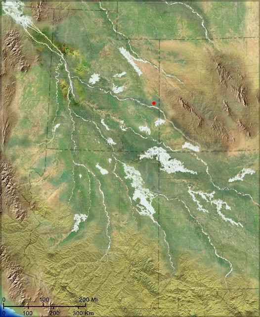
Having left the lofty San Juan Mountains in July, my colleague Wayne Ranney and I headed due east across the alternately arid and irrigated San Luis Valley. Our destination was the Great Sand Dunes of south-central Colorado. The dunefield, located at the extreme east side of the valley, struck me as being somewhat out of context with its surroundings, in a state traditionally characterized by its alpine nature. Yet, it’s the heart of an exquisitely balanced geologic, geographic and climatic system that includes the watershed and windshed of the Sangre de Cristo Mountains, the valley’s sand sheet, and its shallow playa lakes or sabkha.

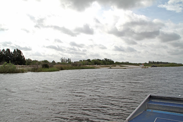
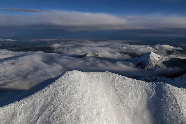
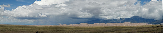
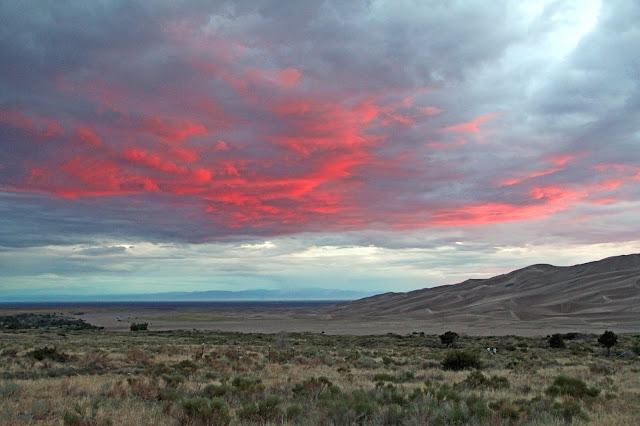
This panoramic photo was taken from the south side of the dunefield looking north. The sand sheet is in the foreground and the Sangre de Cristo Range is in the background. The sabkha (not shown) is off to the west. The earth's curvature is an artifact of Photoshop post-processing. Click on the panorama for a larger view.


Taken from the same perspective, this is the east edge of the Great Sand Dunes.


The system originated when Lake Alamosa, in the valley to the west of the dunefield, drained to the south about 440,000 thousand years ago. Sand from its paleo-lakebed was blown to the east by prevailing southwest winds off the San Juan Mountains. An alcove within the Sangre de Cristo’s accommodated the developing dunefield, assisted by northeast seasonal storm winds and watershed streams that re-cycled the sand back to the dunes. The cycle is actually quite simple, but predicting changes within has been far more complex. For more of the juicy geological details, please visit my previous post Part I entitled the “The Great Sand Dunes – Its Geological Evolution here.


San Luis Basin flanked by the San Juan Mountains on the west and the Sangre de Cristo Range
on the east. The Great Sand Dunes is tucked into a mountain-alcove on the east side of the valley.
Inset map shows relationship to the four basins within the Rio Grande Rift.

Modified from USGS

In 1932 President Herbert Hoover officially created the Great Sand Dunes National Monument, and in 2004 Congress established the 233 square mile-region as a National Park and Preserve. Its 84,670 acres contain more than just sand, and includes high mountain peaks, tundra and lakes, pine and spruce forests, stands of aspen, grassland and wetlands. Recently, Mark Udall, who chairs the U.S. Senate National Parks Committee, proposed the establishment of the Sangre de Cristo National Historic Park to protect many historically and culturally significant sites within the Sangre de Cristo Mountains and the neighboring San Luis Valley region.

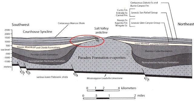
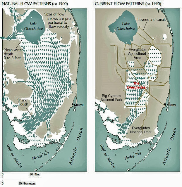
The dunefield’s geological assembly is tied to the operation of the Rio Grande rift that became active some 26 million years ago. Hinging on the west along the San Juan Mountains, it gradually dropped almost four miles on the east. The downdropping of the half-graben forced the horst-block of the Sangre de Cristo’s skyward. Rifting created the accommodation space for the dunefield’s eolian sands that originated in the San Juan’s far to the west and secondarily blown in from the valley’s sand sheet by the prevailing southwesterlies. In conjunction with seasonal, storm-related northeasterlies from the Sangre de Cristo’s, a bimodal wind regime (red arrows) now confines the dunefield to a relatively fixed footprint.  

The Great Sand Dunes are nestled within an embayment of the Sangre de Cristo Mountains
and surrounded by the seasonal streams of Sand and Medano Creeks. The prevailing southwesterlies

and seasonal northeasterlies confine the dunefield. Our camp was located at the red ellipse.
Modified from USGS Map


It’s no wonder why the Spanish explorer Antonio Valverde y Cosio in 1719 christened the Sangre de Cristo’s “Blood of Christ” with its granitic feldspars ablaze in a reddish glow at sunset. The range forms the eastern backdrop beyond the Great Sand Dunes.


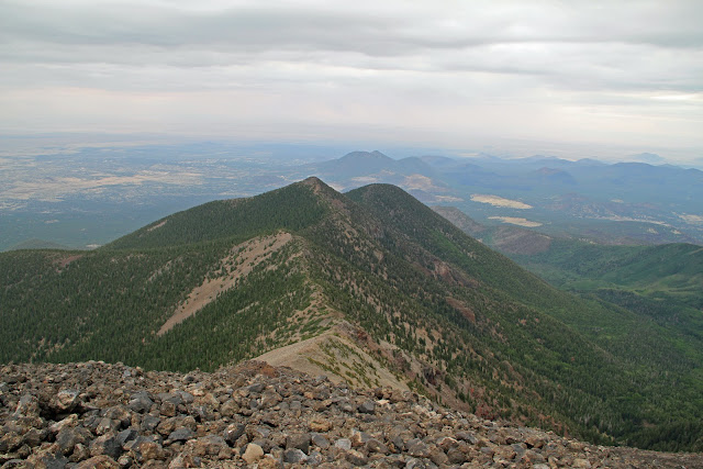
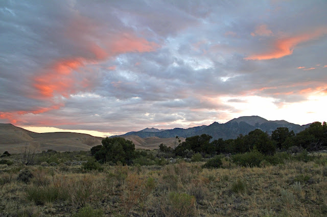
With the Sangre de Cristo Mountains at our backs, we’re looking southwest from camp past the sand sheet, here vegetated with patches of grass and shrubs, at the dunefield’s southern edge. A fiery Colorado sunset showcases the San Juan Mountains on the horizon to the west, the original source of most of the sand to the dunefield. The remainder, about 10%, comes from the Sangre de Cristo’s, at our backs to the east. Surprisingly, only about 10% of the system’s sand is actually contained within the dunefield. The rest is housed within the sand sheet that surrounds the dunefield on three sides.


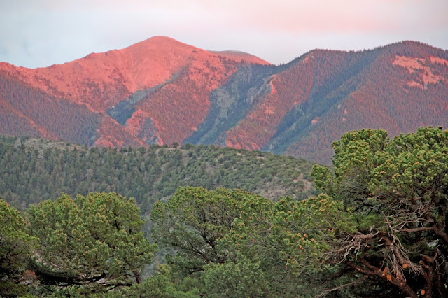
Looking north at sunrise, the tall peak to the right of center in the Sangre de Cristo’s is Mount Herard at 13,340 feet, whose watershed supplies Medano Creek. Piedmont streams such as Medano, Sand and Spring Creeks are essential to the replenishment of Great Sand Dunes by returning sand to the sand sheet beyond the dunes so that the southwesterlies can return it to the dunefield. They also recharge the valley’s aquifer and sustain the extensive wetlands that border the dunes further to the west and south.


Here’s the same view only a few minutes later showing welcomed blue skies. The colors and contrasts of the landforms were fantastic! Notice the low-relief extension of the dunefield toward the mountain front. Wind and water work in concert to replenish the dunefield and keep it confined. When the water table is low in the valley, sand is made available for transport to the dunes from the sand sheet via the prevailing southwesterlies. Thus, the sandscape is replenished and may even migrate outside its normal footprint.

The recycling action of wind and water also contributes to the astounding height of the dunefield and serves to stabilize it with a 7% moisture content below the surface. In addition, the opposing wind regime creates the dunefield’s varying architecture such as reversing, transverse, star and barchan dunes.


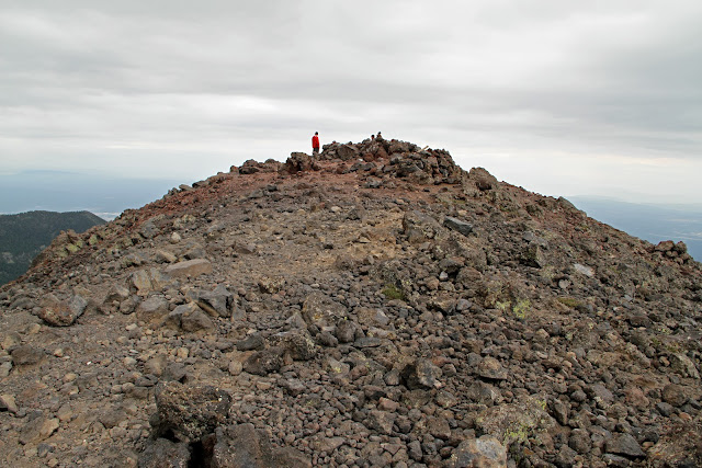
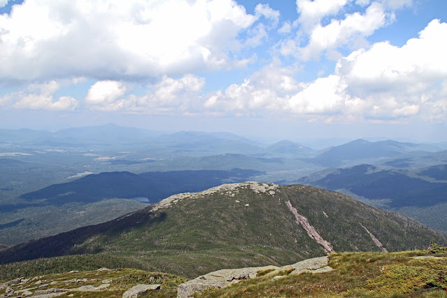
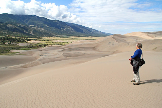
We made a pre-breakfast ascent onto the dunefield from camp, crossing Medano Creek and trudging our way up High Dune, which is actually ranked as a Colorado Peak because of its elevation at 8,691 feet. To the far right in the photo, Star Dune rises 100 feet higher off the valley floor making it the tallest dune in the park. It's all because of the hinging-tilt the valley has experienced due to the Rio Grande rift, although it’s visually imperceptible having been filled with 15,000 feet of alluvium from the mountains.

The complex system of winds that converge at Great Sand Dunes has conspired to create a variety of dune types within the dunefield. Star Dune is characterized by three or more ridges that radiate from its center, the product of wind convergence. This causes the dunes to grow upward rather than migrate laterally. Star dunes are located on the north and southeast edges of the dunefield. Winds that reverse direction produce transverse or barchanoid dunes with foresets facing in opposite directions. Reverse dunes mantle  underlying dunes when the whim of the wind changes its trend. Notice the distant San Juan Mountains sixty five miles across the San Luis Valley making their own weather and desiccating the winds that reach down to the valley.

The composition of all sand betrays its source. The darker appearance of the dunefield’s eolian sand is due to sediments dominated by volcaniclastic rock fragments (51.7%) from the San Juan's. It's dark sand is a good absorber of the sun’s heat. When the air temperature is 80 degrees, the surface can reach a scalding 140 degrees! Notice the depressions or swales within the dunefield. They are sheltered from the wind, and some are close to the watertable. They serve as refugia for plant and wildlife.


Sand is moved about by the wind via three mechanisms: by bodily moving the sand in suspension (providing the wind speed is at least 15 mph); by saltation (with grains leapfrogging, bouncing and hopping along the surface that are too large to be moved by the wind alone); and by surface creep (nudging sand grains along by lightly lifting them briefly off the surface).


From Wikipedia


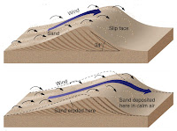
The result of these eolian processes (named after the Greek god Aeolus, keeper of the winds) is sand dunes that migrate across the landscape. As the wind assembles the sand, a dune forms. Sand climbs a long, gently-sloping, windward slope and cascades over the crest onto the shorter downwind side of the dune called the slip-face in the lee of the wind. Sand is deposited there, as the wind’s speed diminishes and loses its capacity to carry sand. Thus, the slip-face is steep and forms an angle of repose that doesn’t exceed 34º. As each new layer of sand falls down the slip-face, cross beds are gradually formed, one layer after another. Over a period of time, the sand dunes advance down wind.


From Wikipedia

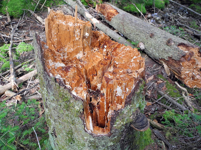
Notice the "active" dunes that have migrated beyond the dunefield’s perimeter onto the piedmont slope that drapes from the mountain front. As they migrate, they bury vegetated areas on the slope and form “ghost forests” of dead, tree stumps (right of center). The low-lying, grassy vegetation acts as a baffle to nullify the movement of the wind at ground level. Saltation ceases when sand grains enter its “dead air” space, which then stabilizes the dunes horizontally.

Eventually, stray sand will be returned to the dunefield by the combined efforts of the Sangre de Cristo’s wind and water regime, the re-cycling process that has confined the dunefield to its seemingly stable footprint. 


We're standing atop High Dune on the eastern front of the dunefield. That’s the braided-channel of Medano Creek running from left to right (here north to south). It has already begun to retreat back toward the mountains, typical of July, and will be completely gone by August or September. In drier years, streams are lost to infiltration within a few kilometers of the mountain front. Again, notice the sand that has invaded the vegetated region beyond the creek onto the shallow alluvial apron.

April is one of the snowiest months at Great Sand Dunes. This is when the seasonal stream of Medano Creek begins to trickle down as the snowpack begins to melt, recycling sand back to the valley floor. By mid to late May, the creek reaches its annual peak. Because the Medano’s sandy creekbed is so wide, the water depth is very shallow. Consequently, small rises in the bed are enough to block the flow. Once the pent-up water rises high enough, it breaks over the dam and creates a “surge flow” with pulses of waves with some reaching 16 inches in height. It’s a popular summer locale to experience waves “breaking” far from the ocean. The creek flows past the dunefield for an additional 8 km and then sinks into the valley floor.


Facing southeast, the Sangre de Cristo's reach to the south into New Mexico. A multitude of alluvial fans meet the sand sheet. Once again, notice the stray, parabolic dunes migrating past the dunefield’s perimeter. The sand sheet’s grassy vegetation holds the “arms” of the dunes in place as the leeward “nose” of the dune migrates forward. The dunes on which I’m standing are reversing dunes, the most common dune on the dunefield, formed during the summer as the wind changes direction. This creates a “Chinese Wall” at the crest of the dunes and also contributes to their great height.


The bands of black sand on many of the dunes are deposits of the heavy mineral magnetite, a crystalline oxide of iron. Brought by the wind from the distant San Juan Mountains, the iron-rich, volcanic minerals become sorted and concentrated by virtue of their greater density. The specific gravity of quartz is 2.7; whereas, magnetite is 5.2. Sorting by density is called placering, with wind being as effective a sorting agent as water (with a specific gravity of 1). Placering is also very apparent on coastal beaches after a storm, and it’s what miners used to pan for gold (SPG 19.3).

Thomas Edison once made the discovery of magnetite bands on a coastal beach in Long Island, something all beachcombers are familiar with. Recognizing its potential commercial value, his enthusiasm preceded his business sense when he purchased the beach and the separation machinery to extract the ore. On his return, he discovered that a storm had reworked the beach and removed the ore for him. Of course, he did come up with another bright idea. Indeed, sand is on the move everywhere by its very nature. You can also read about magnetite on Wayne Ranney’s Great Sand Dunes post here.


Both moving water and wind have the capacity to transport sand long distances before it’s deposited. Fine-grained particles of sediment become airborne in suspension. Along the ground, there is surprisingly little motion due to the wind. We've all seen a car travelling on an unpaved road pulling along a cloud of dust while leaving the loose road surface relatively unscathed. As previously mentioned, sand is moved on the ground by saltation (Latin “to leap”). As a “heavy” grain of sand gets knocked into the air, it falls back down and bumps along another grain. Thus, sand moves along the dune floor and creates secondary wind ripples, seen here. The ripples and the entire dune are an indication of the prevailing wind direction. Again, notice the magnetite-banding.


At 7,800 feet, seasonal conditions include snow and sub-zero temperatures on the dunefield during winter. By definition, a desert is a dry, often sandy region of little rainfall, extreme temperatures and sparse vegetation. Deserts characteristically receive less than 10 inches of rainfall annually. Park rangers refer to the arid and depauperate Great Sand Dunes as “desert-like” with an annual rainfall of about 11 inches. What a contrast of landforms are juxtaposed in this photo!   


When we think of deserts, we generally envision a dry, barren lifeless place. In truth, deserts support an amazing variety of life and are places of stunning beauty and lots of activity. Its seemingly inhospitable environment actually plays host to insects that are well-suited to the harsh conditions. Severe temperatures, high winds, water scarcity and shifting sands all challenge the plants and animals that live on the dunes. This adult Conchuela stink bug with its distinctive red border and red spot feeds on the plants that grow on the dunes but also loves mesquite and alfalfa, the latter grown in the irrigated-valley to the west. Notice the faint trackway left by this dune traveler.


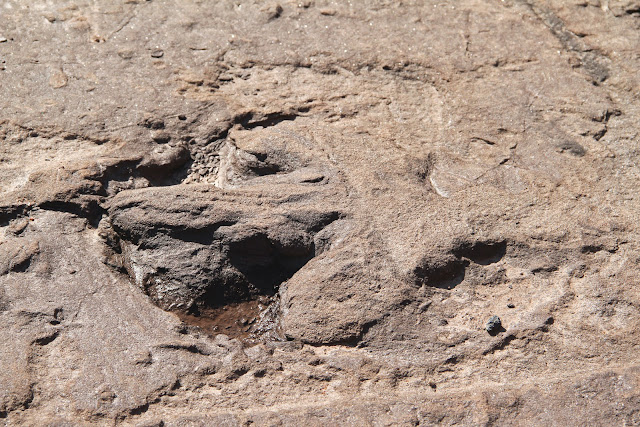
Tiny trackways can be found everywhere in the early morning. After sunset, surface temperatures drop and humidity increases. At night, cooler air from the mountains causes the surface temperatures to fall. Burrowing insects that spent the day undercover to escape the dune’s inhospitable surface conditions emerge to feed and mate in the cool night air. If you walk the dune at night with a flashlight and follow a trackway, you'll find a burrow in one direction and possibly an insect out for a stroll in the other. Notice the human tracks from the previous day and the insect trackway from last night! Reptilian trackways often show a tell-tale tail-drag (pun intended).


A busy nocturnal creature, likely an arthropod, hesitated on a dune and then crossed over its knife-edge crest. On the leeward side, it crossed a narrow band of volcanic magnetite.


Photographed only four inches from the surface, the wind has sculpted the crest of a dune into a sharp, razor-edge, held intact by the sand’s elevated moisture content. The natural world possesses incredible beauty at every scale of magnification.


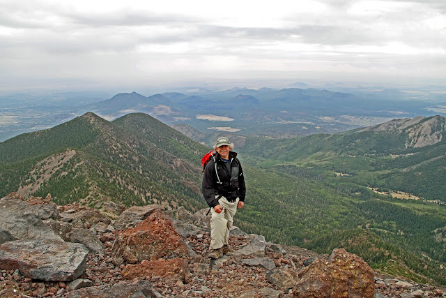
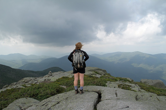
Sand brings out the playfulness in us all, aptly demonstrated by geologist Wayne Ranney.

Photoshop post-processing by John Parmley of http://www.photographybyparmley.com


INFORMATIVE RESOURCES
Ancient Landscapes of the Colorado Plateau by Ron Blakey and Wayne Ranney, 2008.
On the Origin and Age of the Great Sand Dunes, Colorado by Richard F. Madole et al, 2008.
Plateau – The Land and People of the Colorado Plateau by Wayne Ranney, Museum of Northern Arizona, 2009.
Sand – The Never Ending Story by Michael Welland, 2009.
The Geologic History of Colorado's Sangre de Cristo Range by David A. Lindsey, USGS 1349.
The Physics of Blown Sand and Desert Dunes by Ralph A. Bagnold, 1941.


SPECIAL THANKS
I want to personally thank and highly recommend John Parmley of "Photography by Parmley" for his outstanding Photoshop expertise in achieving the multiple image composition pictured above. His website can be found here.

Boston Strong

Powell Point at the Top of the Grand Staircase

$
0
0
KODAKCHROME BASIN
Traveling north on the unpaved Cottonwood Canyon Road in south-central Utah, this overlook oversees the appropriately-named Kodachrome Basin State Park. A National Geographic expedition "Motoring into Escalante Land" first penned the colorful park name in a September 1949 article. Initially, Kodak objected to the magazine's usage of the product name of the film, still in its infancy, without permission, but later recanted after recognizing the obvious marketing value.

Notice the tilted sedimentary beds. Widely-spaced faults and monoclines punctuate the region. The flat-topped summit on the horizon is Powell Point, our destination, about 12 miles as the crow flies.

View looking north from Slick Rock Bench (near Wiggler Wash) at the Kodachrome Basin. Powell Point (center) is atop the Table Cliffs Plateau to the left of the gap on the horizon, while Canaan Peak is off to the right. Note the steeply dipping rocks (Entrada through Straight Cliffs Formation) that form the tail of a monocline between a branch of the Kaibab anticline and the Hackberry Canyon syncline.

THE SAN RAFAEL GROUP
The "picture perfect" vista is brought to you courtesy of the geological San Rafael Group. The multi-member, stratal package formed when a finger-like incursion of the former Panthalassic Ocean and the now-named Pacific Ocean invaded the land from the north and extended into the shallow Utah-Idaho trough during the Middle Jurassic. The depression of the trough was induced subsequent to the formation of an orogenic belt from the west in Nevada. The tectonic event was the Nevadan orogeny, the first of three major mountain-building episodes that completely transformed western North America during the Mesozoic. The mountain belt and its foreland basin are clearly visible on the Middle Jurassic paleo-map below.

The elongate marine embayment, also referred to as the Sundance seaway, deposited alternating sequences of terrestrial and shallow marine deposits. Depending on where you're travelling in the southeast quarter of Utah and western Colorado, you'll see the San Rafael's red and brown mudstones and and shales interjected with light-colored beds of evaporites and eolian sandstones of the Page and Entrada Sandstones, and the Carmel, Curtis and Summerville Formations.

Middle Jurassic Paleography of Western North America
Ron Blakey, Colorado Plateau Geosystems, Inc.


THE PINK CLIFFS OF THE GRAND STAIRCASE
The following spectacular western scene is encountered further north along the Cottonwood Road. We're barely three miles from Cannonville, Utah, situated on Scenic Byway 12. The San Rafael Group's various layers are illuminating the landscape. Drawing ever near, Powell Point anoints the summit of the Grand Staircase's Pink Cliffs at 10,188 feet.

Envision the Grand Staircase as a multi-stepped, geological layercake that begins above the North Rim of the Grand Canyon in Arizona to the south and extends 150 miles to the north into southern Utah. It's subdivided into 6,000 vertical feet of cliffs, the risers of the stairs that are named by color, and intervening terraces or benches. The alternating cliff/slope and bench/terrace configuration is related to varied erosion rates of the various rock types. The cliffs are comprised of harder rocks that are more resistant to erosion (such as sandstone and limestone); whereas, the benches possess softer rocks that erode more readily (with shale and siltstone). 

Modified from nature.nps.gov

The Grand Staircase is the westernmost member of the 1.9 million-acre Grand Staircase-Escalante National Monument, created by President Bill Clinton in 1996. The other two geographical sections are the Kaiparowits Basin and, furthest east, Escalante Canyons.

SKUTUMPAH TERRACE
Powell Point is the highest point on the geological cake, the icing if you will, residing on top of the Pink Cliffs. Below it is a bench, then a step, then another bench, and so on. This photo was taken from the Skutumpah Terrace, below the second riser of the Staircase called the Gray Cliffs to the north, somewhat hidden in the photo. The riser below us, to the south, is the White Cliffs of glistening Navajo Sandstone. The colorful terrace is built on softer, more erodible deposits of the Carmel and the overlying Entrada Sandstone, both related to the advance of the aforementioned seaway.  


THE CLARON FORMATION
Powell Point, seen from atop the Skutumpah Road just to the west of Kodachrome Basin, was named in 1879 by the geologist Clarence Dutton in honor of his famous contemporary colleague John Wesley Powell, the iconic geologist and explorer of the American West. The Point is held up by the white and pink limey cliffs of the Claron Formation, deposited during the Eocene around 55 million years ago in a vast system of freshwater shallow lakes and streams. The lower pink stratum is colored by oxides of the mineral hematite. They are the same formations that have eroded into the ghostly spires, badlands and hoodoos of Bryce Canyon and Cedar Breaks just to the west.

Middle Jurassic Paleography of Western North America
Ron Blakey, Colorado Plateau Geosystems, Inc.

Intertonguing Carmel Formation and Page Sandstone deposits of the San Rafael Group occupy the foreground that became interbedded as the sea level of the Sundance sea transgressed and regressed on land. And in the middle distance, gray badlands and slopes of the Gray Cliffs luxuriate below the high plateau of Powell Point, our next stop.

Powell Point is atop the white and pink Pink Cliffs seen from the Skutumpah Road
that traverses multi-colored strata of the San Rafael Group.
The various benches, slopes and cliffs of the Gray Cliffs are below.

POWELL POINT OF THE TABLE CLIFFS PLATEAU
We've arrived near the top of the Grand Staircase! Powell Point is about four miles to the west of paved Highway 12, where this photo was taken. At one time, like the other concordant high plateaus (consisting of the same strata) of the region, Table Cliffs Plateau was capped by resistant basalt during the Oligocene, which served to protect the underlying Claron Formation from erosion.

The Claron, being weakly-lithified (less rigid and erosion-susceptible), assaulted by frequent freeze-thaw cycles at this lofty elevation, and winnowed away by headward erosion of the Paria River system, has caused Powell Point to retreat as its cliffs are inexorably excavated away. On a grander scale, the Table Cliffs Plateau is situated on the east, high-side of the Paunsaugant fault, a Basin and Range extensional feature that threatens the demise of the other high plateaus, and possibly (likely) the entire Colorado Plateau. It’s only a matter of time.


CRETACEOUS GRAY CLIFFS
The vegetated slopes directly below the Table Cliffs Plateau consist of the Pine Hollow and Canaan Peak Formations deposited in the Paleocene of the Cenozoic Era by streams and rivers. Together, they straddle the boundary between the latest Mesozoic's Cretaceous Period and the earliest Cenozoic, the deposits of which hold up Powell Point. Immediately below, the Cretaceous blue-gray badlands are eroding into the base of the Pink Cliffs.

The Cretaceous Period was a time of tectonic activity, elevated sea level and climate change in western North America. It is estimated that one-third of the world's landmass at the time was submerged during this unprecedented rise in sea level. The units of the Cretaceous record the marine filling of an immense foreland basin that formed as the Sevier orogeny deformed the continent's interior. The Sevier was the second Mesozoic orogeny to transform western North America.

Sevier-induced deformation of the continent’s western interior (related to compression on North America's western margin) and high global eustasy (elevated sea level related to the formation of new oceanic crust) acted in concert to drown the craton (continental interior) in a vast, north-south inland sea that reached from the Arctic to the Gulf of Mexico, and divided the newly-formed North American continent in two. The vertical and horizontal oscillations of this Western Interior seaway blanketed its bottom with mud, while its shoreline was marked with swamps fed by sediments from east-flowing rivers that originated from mountains of the Sevier orogenic belt to the west. That explains why you can find sea shells in Kansas, sharks teeth in South Dakota and beach sands throughout the Great Plains.

Late Cretaceous Paleography of Western North America
Ron Blakey, Colorado Plateau Geosystems, Inc.

THE BIRTH OF THE BLUES
“The Blues” situated below the white and pink Claron cliffs of Powell Point, consist of drab, blue-gray fluvial and floodplain sequences of the highly fossiliferous Kaiparowits Formation. The descending strata include the Wahweap, Straight Cliffs, Tropic Shale and Dakota Formations. The Staircase's Gray Cliffs are a series of low cliffs formed from hard sandstones with several intervening benches of softer sandstones and shales. These deposits formed during the great epeirogenic (continental) flood of the Western Interior Seaway, biblical in proportions but not in origin. Amen.


THE GEOLOGICAL BIG PICTURE
The following diagram of the Grand Staircase illustrates the direction we travelled north from the Skutumpah Terrace to Powell Point atop the Pink Cliffs. As we gained altitude and crossed from each successive bench and riser, we also rose stratigraphically into deposits that were laid down earlier, from the Mesozoic through the Cenozoic.

At its maximum development at about 90 million years ago, the continental sea inundated two-thirds of the eastern portions of Utah and Arizona. The sea's two-major transgressions and regressions (advances and retreats) left a stratigraphic record of largely sandstones and shales that blanketed the landscape, covering the entire Grand Staircase. Its deposits, originally at sea level, now reside at an elevation of two miles!

Stated another way, if standing on Powell Point today looking south down the Grand Staircase in the direction of the Grand Canyon, the lower benches and risers of the White, Vermilion and Chocolate Cliffs have lost their overlying Cretaceous strata from erosion, referred to by geologists as "unroofing." This is a consequence of the uplift of the entire Colorado Plateau on which the Grand Staircase is a part. 

During the Late Cretaceous, the Colorado Plateau is thought to have initiated a "gentle" bouyant ascent due to the Laramide orogeny, the third mountain-building event to transform western North America. Rather than creating a range of mountains, as it did with the Rockies, the Laramide created the Colorado Plateau, a largely un-deformed and yet two-mile uplifted-block of continental crust. That event carried sediments formed at sea level to the various cliffs and benches of the Grand Staircase. With all that we know, the timing and precise mechanism of this and subsequent uplift has remained a major enigma in geology for almost 150 years.


Modified from Geologic Road Guides to Grand Staircase-Escalante National Monument, Utah,
Utah Geological Association Publication 29

Our ascent of the upper portion of the Grand Staircase has taken us from the Middle Jurassic period of the Mesozoic (about 170 million years ago) through the Eocene epoch of the early Cenozoic (about 55 million years ago). Within that time frame, a Middle Jurassic seaway invaded the region from the west and deposited the sediments of the San Rafael Group, seen on the Skutumpah Terrace. Tectonic collisions along North America's west coast beginning in the latest Jurassic formed the Western Interior seaway, whose Late Cretaceous sediments are seen within the Gray Cliffs. And during the Eocene, pink and gray limey deposits of the Claron Formation were deposited within a system of freshwater streams and lakes, seen in the Pink Cliffs.

A Curious Intra-Formational, Angular Unconformity within the Chinle Formation: Part I - A Conspiracy of Events

$
0
0
Within Moab Canyon on the Colorado River between Castle and Moab-Spanish Valleys, the Chinle Formation possesses a spectacular angular unconformity. Its distinctiveness resides both in its intra-formational locale (rather than between two lithologically distinct formations) and the tectonic context in which it originated. What events conspired to create this curious deformational feature within the Chinle? What can it tell us about the ancient landscape?  The answer is contained in the interplay of events that occurred regionally, globally and even astronomically.


WHAT’S AN ANGULAR UNCONFORMITY?
If the successive, horizontal deposition of sedimentary rock layers is interrupted, say by erosion of a layer or a failure of deposition, the gap in time between the strata of different ages is called an unconformity. Unconformities are extremely common in the rock record and generally indicate a regional or even global geological event.


Angular unconformities occur where an older, underlying package of sediments has been uplifted, tilted and truncated by erosion, followed by a younger package that was deposited horizontally on the erosion surface. This gap in the rock record generally occurs from a regional tectonic event which changes the altitude and attitude of the bedding before sedimentation resumes. Compare the diagram below with the photo above. 


WHERE ARE WE?
We’re on the Colorado Plateau in east-central Utah within the Paradox basin of late Paleozoic time. Paleogeographic reconstructions place us between 5º and 15º north of the paleo-equator during the Triassic, the time of deposition of the Chinle Formation.  The town of Moab and Canyonlands National Park are off to the southwest, while Arches is just to the north.


The unconformity is east of town within Moab Canyon along the Colorado River across from Scenic Byway 128. Running from the northeast to the southwest, the Colorado transects a succession of NW-SE-trending, salt-generated, anticlinal valleys (first Onion-Fisher-Sinbad, then Salt-Cache, Castle-Paradox Valley) before entering Moab Canyon (the location of our unconformity and others), and then emerges from the canyon into another salt-intruded anticline at Moab-Spanish Valley.

The Colorado River flows NE to SW through a succession of salt-intruded valleys.
The Chinle unconformity in the photo is exposed at river level within Moab Canyon.
It is displayed at numerous locations throughout the basin.
Google Earth

Once again, what processes are responsible for the formation of the unconformity? Hint: The region’s many anticlines, synclines and the unconformity share a common genesis.

THE PENNSYLVANIAN AND PERMIAN PERIODS OF THE LATE PALEOZOIC
The Pennsylvanian and Permian Periods herald the close of the late Paleozoic, a time of expansion for marine invertebrates, gigantism amongst arthropods, the diversification of terrestrial stem tetrapods, and the advent of the amniote egg. Pennsylvanian coal forests in eastern North America’s more northerly paleo-latitudes attest to swampy, humid conditions, while western paleo-equatorial North America was largely arid. At the South Pole, extensive glaciation repeatedly waxed and waned causing global sea level to successively rise and fall. The wide range of climatic extremes was related to the development of a supercontinent, when things came together tectonically.


Pangaea before the initiation of break up in the Early Permian (280 Myr)
Note the orogen within the Laurussian-Gondwanan collision zone
and the South Polar continental ice sheet.
Ron Blakey and Colorado Plateau Geosystems, Inc.

Near the end of the Mississippian Period, the majority of our planet’s landmasses began to assemble into a supercontinent called Pangaea (Greek for “all lands”). It spanned the poles and was surrounded by a vast global sea called the Panthalassic (Greek for “all oceans”). Pangaea was largely the unification of the megacontinents of equatorial-situated Laurussia (North America and Eurasia) and australly-situated Gondwana (most of the modern South Hemisphere continents), and lasted for over 100 million years.

GLOBAL AND REGIONAL OROGENESIS
When continents tectonically collide, there’s nowhere to go but up. Orogeny (literally “mountain creation”) occurs when landmasses converge. The competition for space within the Laurussian-Gondwanan collision zone created a Himalayan-esque, trans-global mountain chain. Today, the eroded remnants are distributed amongst Pangaea’s globally-rifted siblings, and in North America, form the Appalachians.


The unification of Laurussia and Gondwana brought Africa into contact with North America’s eastern margin (using contemporary coordinates) along the Appalachian-Caledonian-Herycnian suture, which extends through Greenland into western and northern Europe. Along the collision zone to the southeast, South America accreted at the Ouachita-Marathon-Sonoran suture, building mountains from Arkansas and Texas into Mexico.

Curiously, the South American collision is thought to have created a second mountain system further to the west of the suture within Laurussia’s interior called the Ancestral Rocky Mountains (circled on the map below). 


The red dot depicts the location of the future Chinle unconformity.
Late Pennsylvanian paleomap (300 Myr ago)
Modified from Ron Blakey and Colorado Plateau Geosystems, Inc.

ENIGMATIC ORIGINS
Traditionally, the uplift of the Ancestral Rocky Mountains has been ascribed to a continent-continent collision of the conjoined masses of Laurussia and Gondwana. But not all tectonic aficionados agree with the intraplate geometry of a South American collision from the southeast having raised a range that trends NW-SE and so far-afield from the effects of the Ouachita-Marathon convergent margin. They also find fault (pun intended) with the extensionally-derived, “pull apart” structure of the marine basins that also formed as a part of the Ancestral Rockies. Opponents advocate for a volcanic arc-collision occurring somewhere from the southwest, likely within Mexico, which fits better with the Ancestral’s orientation and the compressionally-derived, foreland structure of its basins. 


The arrow indicates the traditional collision vector from the southeast.
Modified from Wood (1987) and Houch (1998)

A third hypothesis (and there’s undoubtedly more) evokes pre-existing weaknesses within the craton that, when compressed, uplifted the range along deep Proterozoic basement lineaments, a Precambrian "inherited" defect, if you will. In "Canyonlands Country" by geologist Donald Baars, he says "These deep-seated Precambrian faults set the geological stage, and will come back to haunt us throughout geologic time."   

TECTONIC INHERITANCE
Rodinia was the supercontinent that preceded Pangaea by half a billion years, give or take. When Antarctica separated from Rodinia’s southwest paleo-shore in the Late Proterozoic-Early Cambrian, the rifting event sent extensional shockwaves through the craton. Notice the orientation of the normal faults within Rodinia's interior (below). The NW-SE trend of the Ancestral’s ranges and basins reflects these deep-seated, basement-penetrating structures.

These zones of structural weakness were predisposed to future re-activation during Pennsylvanian-Permian compressional tectonics and even Cretaceous-Tertiary age Laramide contractional structures (such as monocline orientation). Tectonic inheritance of structural features in continental cycles, especially with intraplate orogenesis, is a recurring theme in the science of plate tectonics. We’ll see inheritance resurface later (literally) in our discussion of the Chinle unconformity.


Incidentally, the Late Proterozoic rifts that formed throughout Rodinia when it fractured apart likely induced "inversion" tectonics (extensional faults rejuvenating contractionally) in cratonic platforms of its rifted siblings worldwide.

ANCESTORS OF THE ROCKIES
The Ancestral Rocky Mountains, named after the modern Rockies that would eventually reside in roughly the same locale, rose from the sea in western equatorial Pangaea beginning in the Late Mississippian, reached their greatest intensity in the Middle Pennsylvanian, and ended their ascent in the Early Permian. An enigma to this day, they rose amagmatically (without volcanism) in an intra-cratonic and intra-plate setting far from any known plate boundary (1,500 km).

They consisted of a collection of crystalline, Precambrian basement-cored, NW-SE-trending ranges (referred to as highlands and uplifts) and paired fault-bounded depressions (referred to as basins and troughs) from Chihuahua, Mexico, through Oklahoma, Texas, Colorado, Utah and up to British Columbia, Canada. Initially, the many basins were in communication with the marine waters of the Panthalassic Ocean. 

Middle Pennsylvanian (300 Myr ago) paleograph of Pangaea’s Southwest
Illustrating the uplifts and basins of the Ancestral Rocky Mountains.
Note the future location of the Chinle unconformity (red dot) within the Paradox Basin.
Modified from Ron Blakey and Colorado Plateau Geosystems, Inc.

THE UNCOMPAHGRE UPLIFT AND THE PARADOX BASIN
On the southwest flank of the Ancestral range, the Uncompahgre (UH) highlands (alternately called an uplift) was bordered on the east by the Central Colorado basin (CCB) and on the west by the elongate Paradox basin (PaB). Tectonically associated with the highland’s rise, the Paradox basin rapidly subsided and assumed an asymmetric profile 200 miles in breadth and as much as 33,000 square miles (about the size of Maine). As the entire range ascended, erosion worked to bring it down, shedding deposits into the waters of the intervening basins in large debris fans. The Paradox basin's relationship with the sea became intermittent but with astounding regularity.  

Map of the Paradox Basin, the extent of which is delineated by salt of the Paradox Formation.
The red ellipse encloses the region of our unconformity.
Modified from Nuccio and Condon, 1996.

CYCLIC SEDIMENTATION
Closest to the rising front, 16,000 feet of the Uncompahgre’s arkosic, Precambrian sediments were shed into the Paradox basin as it rapidly subsided (northeast in diagram). Moving away from the highlands, the high seas poured into the deepest portion of the basin from the north and south. When the cyclically-oscillating global seas dropped low enough, the basin’s shallow shelf (labelled southwest) prevented the entry of sea water.

Cut off from the sea, the basin became a hypersaline lake as water evaporated within the restricted basin in the hot, arid Pennsylvanian climate of western Pangaea. Salt brines precipitated from the briny solution and settled to the deepest depression of the basin where they accumulated. The depositional scenario reversed when sea level cyclically rose again, reentered the basin and diluted the briny concentrate. And so on.

Schematic cross-section through the Paradox basin with carbonate shelf facies (pink) to the southwest, evaporite facies (olive) in the basin center and northeastern clastic facies against the Uncompahgre highlands. Notice that the Uncompahgre highlands and their parent Ancestral Rocky Mountains are cored by Precambrian basement rocks (gray) that were shed back into the basin subsequent to the range's tectonic uplift.
Modified after Stevenson and Baars, 1986


These events repeated an amazing 33 times with pulse-like regularity and are recorded within the multiple evaporite-cycles of the Paradox Formation, called cyclothems. The deepest portion of the basin received as much as 6,000 feet of evaporite-dominated sequences and is the location of our Chinle unconformity. For the record, the broad, shallow outer-shelf of the Paradox basin was teeming with marine life (note the algal mounds above) to the south and southwest. This region of the basin accumulated carbonate-dominated deposits that were also affected by the global oscillations of the sea. The basin sequences are found within the Paradox Formation of the Hermosa Group.


From geomechanics.geol.pdx.edu

The Paradox Formation was conformably succeeded by the alternating terrestrial eolian and fluvial, and marine shales and limestones of the Honaker Trail formation, the uppermost unit of the Hermosa Group within the Paradox basin. Like the Paradox Formation, the Honaker Trail Formation continued to record cyclic sea level fluctuations but contained no evaporites.

ABSAROKA HIGH SEAS
The rising Pennsylvanian and Permian seas that flooded the Paradox also inundated other neighboring basins and low-lying regions both regionally and worldwide. Called the Absaroka transgression, it was not a smooth event but progressed with sea levels that constantly rose and fell, withdrawing and advancing onto land and communicating basins.
From earthscienceinmaine.wikispaces.com

For the record, the Absaroka wasn’t the first marine highstand to flood the planet. It was actually the fourth of six complete transgressive-regressive cycles during the Phanerozoic. Why global changes in sea level occur, called eustasy, is a complex process partially involving tectonoeustasy (with the shallowing of ocean basins in rift zones) and glacioeustasy (as climate triggers glaciation and deglaciation).


PENNSYLVANIAN POLAR ICE
Pangaea lasted about 100 million years from the Late Mississippian period until the Late Triassic, when it ultimately fragmented apart. Like previous supercontinents, its enormous landmass profoundly influenced the Earth’s geosphere, atmosphere, hydrosphere and biosphere. With progressive cooling, Pangaea was thought to possess extensive continental glaciers at the South Pole that locked up a substantial portion of the planet’s water, enough to lower the level of the global seas. Conversely, deglaciation flooded the seas and basins with which the seas communicated. We are witnessing this process today in reverse as deglaciation adds water to the planet’s hydrologic budget and triggers a rise in sea level.


From wikipedia

GLACIOEUSTASY
Thus, the basins of the Ancestral Rockies received marine waters that cyclically fluctuated with the waxing and waning of glacial ice, estimated to range from 100 to 230 meters of sea level change. Spanning 60 million years, the late Paleozoic ice age was the most severe glaciation in the Phanerozoic, far exceeding the more familiar ice ages of the Pleistocene in the northern latitudes.   


Why South Polar glaciation was triggered during the late Paleozoic has a great deal to do with the formation of Pangaea. Stretching from pole to pole, ocean and atmospheric circulation was drastically altered. Mountain ranges were uplifted that altered wind patterns and precipitation. Climate determinants, however, were not only terrestrial but extra-terrestrial.

MILANKOVITCH CYCLES
Cyclic sedimentation in Pennsylvanian rocks is not unique to the Paradox basin but has been recognized in basins around the world. After all, the Absaroka transgression was a global event that affected all low-lying regions in communication with the sea. The consensus is that the sea level changes were caused by regular climate fluctuations that triggered the alternating accumulation and melting of glacial ice in Pangaea’s South Polar region. While the waxing and waning of Pennsylvanian polar ice is the source of the cyclic changes in sea level, the cause of the fluctuations of the climate is thought to be extra-terrestrial or astronomical.


Our planet derives its energy from the sun, but the amount of energy we receive is not always the same. The late Paleozoic sun was less bright than it is today, 3% less than modern values. But solar luminosity (the amount of energy that reaches us) is also related to sunspots and the Earth’s orbit. The Earth gyrates and wobbles in its solar orbit such that the amount of sun reaching our planet varies. Milutin Milankovitch, a Serbian geophysicist in the 1920’s and 30’s, hypothesized that climatic fluctuations are related to the position of the Earth as it travels about the sun.

Orbital factors such as precession (axis wobble), obliquity (axis tilt) and eccentricity (roundness) effect the amount of light reaching the Earth’s surface (solar insolation), and hence affect the planet’s climate. Each of these motions possesses a time period, the sum of which affects climate by driving the hot and cold cycles that produce glaciation. Orbital variations clearly had a substantial impact on Pangaean ice volume. Within the cyclothems of the Paradox basin, the repetitive successions (cyclicity) of Pennsylvanian marine and non-marine sediments are considered to be the stratigraphic signature of orbitally-controlled ice volume fluctuations during the late Paleozoic. 


From windows2universe.org


Why are the effects of the Milankovitch cycles “suddenly” seen in the late Paleozoic? The cycles have likely been occurring over a vast period of geologic time, but conditions were optimal for recording the changes with Pangaea sprawling across the South Pole, a climate perfect for glaciation and deglaciation, and shallow marine conditions within the basins of the Ancestral Rocky Mountains. Small periodic changes in sea level profoundly affected evaporite sedimentation and cyclization within the Ancestral’s basins.

PARADOX BURIAL
The entire process of mountain-uplift, basin-subsidence, oscillating sea level and cyclic salt deposition continued throughout the Middle Pennsylvanian and into the Early Permian. During the Permian, highland uplift and basin subsidence continued but at a declining rate as deposits of the Cutler Group (strat column above) derived from the Uncompahgre uplift blanketed the cyclic deposits of the Hermosa Group. Eventually, the Paradox basin was overtopped as the Panthalassic shoreline made a final wavering westward retreat.

Although greatly eroded in the Triassic, the remnants of the Ancestral Rockies (assisted by the Mogollon highlands to the south and the distant Southern Appalachians to the east) covered the Paradox basin in its entirety with the Lower Triassic Moenkopi Formation’s deep red mix of tidal flat and coastal plain sandstones, mudstones and shales. The Triassic closed with sandstones, siltstones, conglomerates, mudstones and limestones of the Upper Triassic Chinle Formation deposited within an alluvial and lacustrine environment. Like the Moenkopi, the Chinle was derived regionally from the same sources especially the much-reduced Uncompahgre highlands.

Paleographic reconstruction of Pangaea's Southwest
during deposition of the Owl Rock Member of the Chinle Formation.
The Chinle's source is from the Uncompahgre highlands, the Mogollon highlands
and the distant Southern Applachians to the east.
Modified from Blakey and Gubitosa, 1983 and Fillmore, 2011


The angular unconformity within the Chinle Formation is located several miles west of the uplifted front of the Uncompahgre highlands in the shadow of its eroding flanks and within the confines of the deepest portion of the infilled Paradox basin. And let the truth be told, the beds of the underlying Moenkopi Formation and the even-deeper Cutler Formation also possess similar unconformities from the same regional geological scenario, which has yet to be discussed.

As for the once precipitous Ancestral Rockies, it wasn’t until the Jurassic that eolian sediments finally buried the once great range. Deposition and burial continued with the epeirogenic inland seas of the Cretaceous and Early Tertiary, further entombing the detritus of the Ancestral Rockies, the only remaining record of their existence.

THE BIG PICTURE BEGINS TO TAKE SHAPE
In summary, a complex relationship likely exists between Rodinia’s fragmentation, tectonic inheritance and Ancestral Rocky Mountain orogenesis; and between the Pangaean climate, astronomical solar forcing, cyclical South Polar glaciation, Absaroka glacioeustasy and cyclical evaporite sedimentation.


But there’s more to the story, and I’ve run out of space. We still must explain the genesis of the intra-formational, angular unconformity within the Chinle Formation, and if you haven't guessed by now, it has to do with salt.

Stay tuned for Part II.

VERY INFORMATIVE RESOURCES
"Ancient Landscapes of the Colorado Plateau" by Ron Blakey and Wayne Ranney, 2008.
"A Traveler’s Guide to the Geology of the Colorado Plateau" by Donald L. Baars, 2002.
"Geological Evolution of the Colorado Plateau of Eastern Utah and Western Colorado" by Robert Fillmore, 2011.

A Curious Intra-Formational, Angular Unconformity within the Chinle Formation: Part II – The Salt of the Earth

$
0
0
“The same regions do not remain always sea or always land,
But all change their condition in the course of time.”
Aristotle, Meteorologica

In my previous post entitled “Part I – A Conspiracy of Events”, I posed two questions about an intra-formational, angular unconformity within the Chinle Formation of Moab Canyon, Utah. "What events conspired to create this unconformity?" and "What can it tell us about the ancient landscape?"

Those events (read about them here) incIude global plate tectonics, intraplate orogenesis, Pangaean climatology, australly-induced glacioeustasy, Milankovitch-influenced solar forcing and cyclical, basin evaporite sedimentation. But there’s one critical detail left to discuss. It's the physical behavior of salt when placed under a load or halokinesis for short.


This intra-formational, angular unconformity within the Chinle Formation
re-appears at the bottom of this post with its bedding drawn in.


FISHER VALLEY, UTAH
We’re standing on the banks of the Colorado River over 4,000 feet above sea level in east-central Utah, where the view is nothing less than spectacular. For reference, the Grand Canyon is over 275 miles downriver in Arizona. This is Richards Amphitheater at the entry to Fisher Valley. The solitary spires belong to Fisher Towers that are eroding from the valley’s north flank (left). The rampart on the valley’s south flank (right) is a cluster of mesas that separates Fisher from Castle Valley.
Both valleys are flat-bottomed and are curiously oriented northwest to southeast. Counter-intuitively and visually-contradictory, Fisher Valley resides on the crest of an elongate anticline. 

From here, the angular unconformity is ten miles downriver, but there are actually many regionally, and not just within the Chinle. On this late Spring day, the Oligocene laccolithic La Sal Mountains retain their winter snows. The derivation of their name dates back to the Spanish who called them the "Salt Mountains", a hint at what lies buried beneath the valley floor.

Ascending the mesa (left), it is composed of the Cutler, Moenkopi and Chinle Formations.
The cliff-former is Wingate Sandstone with a vegetated-cap of Kayenta.

The Navajo Sandstone has eroded back on the mesa-tops.

LANDSCAPE ARCHITECTURE IN REVERSE
Just out of view, the Colorado bends to the right nudging past Fisher Valley, and in succession, transects three more valleys that are essentially parallel in their orientation. The valleys are anticlines that have collapsed along their crests.


An anticline is formed from stratified rock that has folded upward with its beds sloping downward from the crest, thereby creating a landform with positive relief. Yet here, we have the opposite geomorphology, a negative relief landform with a flat floor. The reverse in architecture from what is anticipated is a result of collapse along the axis of the anticline. Buried salt is the culprit, but I’m getting a little ahead of myself. 

View southeast across Richards Amphitheater from Utah Highway 128 known locally as the River Road.
Fisher Towers (center) is eroding from the adjoining mesa.
The opposite mesa (right) defines the southern flank of Fisher Valley
with the badlands of the Onion Creek diapir interposed.
We just passed Castle Valley off to the right.
The Cutler Formation and Quaternary fill blankets the valley floor.

THE "BIG PICTURE" FROM WAY UP
Facing southeast, the region is within the Paradox basin of Pennsylvanian and Permian time. The marine basin has been filled in for about 300 million years, but its buried contents have profoundly altered the contemporary landscape, and still do!


The Colorado River can be seen entering from the lower left, the location of my Fisher Valley photo. It then noses across Fisher, Cache and Castle Valleys before plunging into Moab Canyon, the location of the Chinle unconformity on the lower right. Upon its emergence (not seen), it crosses Moab Valley, the fourth anticlinal landform, rather than follow the more logical path down the axis of the valley. Geologists have been trying to make sense of these valleys and the river’s transecting course for 150 years in this land of geological enigmas, paradoxes and contradictions.


Notice that Cache Valley (bottom center) appears to be in an earlier stage of development than the others. Its NW-SE orientation has not yet fully developed nor has its fully-collapsed, flat bottom. Interestingly, a shallow syncline is evident amongst the mesas between the Fisher Valley and Castle Valley anticlines. Also, observe that the strata flanking Fisher and Castle Valleys forms two long escarpments by turning upward (red arrows) with the mesa dipping to the north above Fisher Valley and the opposite below Castle Valley.

The stratal geometry implies a once-continuous, anticlinal trajectory that existed over the intervening landscape. Might there be a formative relationship between the anticlinal valleys, their orientation, the up-turned strata, and even the unconformity downriver? Think salt.

FISHER TOWERS
If the majestic pinnacles of Fisher Towers appear remotely familiar, it’s because they’ve been the backdrop in scores of movies and advertisements. The tallest spire is Titan, topping out at 900 feet, a favorite of rock climbers. The lithology displayed in the towers and adjoining mesa typifies the stratigraphy of the region and tells a geological story of a long-vanished mountain range. The lithology and geomorphology of the valleys tell a story that's equally incredible.


The towers are weathering out from the mesa on Fisher Valley’s north flank. They are hewn from purplish-brown, coarse-grained arkosic sandstones and conglomerates of the Permian Cutler Formation and capped by knobby, dark brown Early Triassic Moenkopi sandstones and shales. Higher up on the mesa (left), upper Moenkopi beds merge with slopes of overlying Late Triassic Chinle conglomerates and sandstones.

These Permian and Triassic clastic deposits came off the Uncompahgre highlands to the northeast, one of a series of mountain ranges belonging to the Ancestral Rocky Mountains that reached its greatest intensity between the Middle Pennsylvanian and Early Permian. Being so close to the mountain-front, the Cutler is extremely thick and contains sizable Precambrian clasts derived from the uplifted-core of the once great range, a veritable geological signature of their existence. Read about the Ancestral Rockies here.


Following the Triassic, a transition to increased and prolonged aridity witnessed the deposition of the Glen Canyon Group's sandstone threesome. Overlying the Chinle slopes, cliffs of black desert-varnished, reddish-brown Early Jurassic Wingate Sandstone (upper left) rise in the mesa and are capped with a veneer of ledgy, fluvial Kayenta Sandstone. On the mesa-tops (not seen), the eolian, Sahara-esque Jurassic Navajo Sandstone has eroded well-back. The Cretaceous and Neogene successions of the Western Cretaceous Seaway have completely unroofed from the region, a consequence of Colorado Plateau uplift.

Check out Fisher Towers in this Citibank video here. The stratigraphy is somewhat out of order, but the scenery is all there.

CASTLE VALLEY
After Fisher Valley, the Colorado River skirts the head of neighboring Castle Valley, flowing right to left (northeast to southwest) along the cliff-line in the distance. Our perspective is exactly opposite that of the Fisher Valley photo. This time we’re in the foothills of the La Sal’s with the mountains at our backs looking northwest instead of southeast. The prominent spire of Castleton Tower is weathering from the cluster of mesas that separates Castle from Fisher Valley. 


The stratigraphy and geomorphology, with a few noteworthy exceptions, is the equivalent of Fisher Valley. It's because the valleys share a common genesis by the rise and subsequent collapse of their initial anticlinal structures. 


CASTLETON TOWER
On closer inspection, Castleton Tower (a.k.a. Castle Rock) bears a similarity to Fisher Towers and its parent mesa, only composed of formations slightly higher in the stratigraphic column. The valley floor and base of the mesas flanking Castle Valley largely consist of the Cutler Formation in addition to a flotsom and jetsom of Neogene fill. The Cutler is separated from the slopes of the overlying Early Triassic Moenkopi Formation by a thin, white bed of gypsum, thought to be an eolian sand sheet. Look for it in the photo.


Ascending the slope, the Moenkopi is separated from the Late Triassic Chinle Formation by its basal Shinarump Conglomerate Member, which is faintly visible on the profiled-slope just below Castleton Tower. Rising above the Triassic slopes, Castleton Tower and neighboring Parriott Mesa are held up by cliff-forming Wingate Sandstones with a thin cap of Kayenta Sandstone. The mesas, buttes and plateaus of Castle Valley are concordant with those of Fisher Valley, meaning they are in agreement structurally and stratigraphically.

Notice the profound inclination of Parriott Mesa and its bedding. The pattern of dipping and stratal geometry on the various mesas within the valleys and their flanking escarpments suggest a genetic link. What is the landscape trying to tell us about its past? Hint: The geological process responsible for the landscape's formation and deformation are related to the behavior of compressed salt, a process referred to as "salt tectonics." The process is regional, but without a global and astronomical interplay, it never would have occurred! 


Here's a television commercial featuring Castleton Tower and a 1964 Chevrolet.

THE MIDDLE PENNSYLVANIAN PARADOX BASIN
Back in Middle Pennsylvanian through early Permian time, the Paradox basin extended from eastern Utah into western Colorado and a small slice of northwestern New Mexico. The epeirogenic (land-based) marine-basin formed contemporaneously with the Uncompahgre highlands, which was a NW-SE-trending mountain range on the southwestern flank of the long-gone Ancestral Rocky Mountains. The Ancestral's were a mosiac of about 20 basement-cored arches and adjoining basins that virtually uplifted from the Panthalassic sea from Texas up into Idaho, roughly in the same locale as the modern Rocky Mountains, their namesake.  


As the Uncompahgre highlands tectonically-uplifted, the adjacent Paradox basin reflexively-subsided, thereby creating an asymmetrical, ovoid trough with its deepest part nearest the Uncompahgre fault. The basin remained in intermittent communication with the open sea on the west and south. As global sea levels rose and fell during Pennsylvanian time, tied to glacial cycles of freezing and melting at the South Pole, the Paradox basin was flooded with great regularity an astounding 33 times. Again, the details are all in Part I here.


Middle Pennsylvanian (315 Myr) Paleo-view of the Ancestral Rocky Mountains
Note the location of the Uncompahgre highlands UH) and the Paradox basin (PaB).
The red dot depicts the locale of the Chinle unconformity near the center of the basin.
Modified from Ron Blakey and Colorado Plateau Geosystems, Inc.


THE FACIES OF THE PARADOX BASIN
The 12,000 square mile (190 by 95 miles) extent of the Paradox basin (red line) is defined by evaporite (salt) deposits of the Middle Pennsylvanian Paradox Formation.  The character of the rocks within the basin was contingent on their proximity to the rising front of the Uncompahgre highlands AND their locale within the basin. Sedimentation kept pace with subsidence which maintained a consistently shallow depth to the basin.

ALONG THE FRONT...
From the Middle Pennsylvanian through the Early Permian, the developing basin was deepest and received thick successions of boulder to pebble clastics along the Uncompahgre front (Gateway, CO for reference), which is represented along the modern Uncompahgre Plateau. The siliciclastics are the “undivided” (“undifferentiated”) Cutler Formation’s conglomerates and sandstones that are strongly progradational to the southwest.

PROXIMAL TO THE FRONT...
Away (proximal) from the front (the locale of Fisher Valley), the basin received thinner and finer “undivided” Cutler clastics deposited over evaporites of the Hermosa Group’s Honaker Trail and deeper Paradox Formation’s evaporites, cyclically bedded with black shale, dolomite and anhydrite. The Hermosa Group's third and lowermost member is the Pinkerton Trail Formation occupying the bottom of the basin.

MEDIAL TO LATERAL BASIN...
Further southwest into the (medial) basin (beginning with the locale of Castle through Moab Valley, into Canyonlands and beyond), the Cutler Formation assumes Group status with it becoming thicker and multi-formational (such as the Cedar Mesa, Organ Rock and White Rim Formations). Beneath the Cutler Group, the deeper basin received the Paradox Formation's evaporite-dominated deposits derived from the sea. Furthest from the front (distal) on the basin’s shallow shelf, the Paradox Formation developed cyclical carbonate-dominated sedimentation with petroleum-containing algal bioherms.

Map of Uncompahgre Highland-Paradox Basin System
The boundary of the basin (red) is defined by the evaporite deposits of the Paradox Formation.
Basin-fill consists of carbonate (shelf) and evaporite (center) facies of the Paradox Formation, mixed siliciclastics of the overlying Honaker Trail Formation and siliciclastics of the Cutler (“undivided” Cutler Formation proximally and Group status medially and distally). Note the location of Fisher and Castle Valleys, and the Chinle unconformity (red dot), relevant to our discussion.
Modified from Barbeau, 2003


STRAT STATS
The following stratigraphic column reflects the varied lithology of the Paradox basin. To the right are deposits closest to the front, while to the left, it progresses through the basin center to the shelf. The four valleys in our discussion (and the Chinle unconformity), reside within the proximal and the beginning of the basin. Of interest are the buried evaporites within the Paradox Formation (yellow).  


Modified from Barbeau, 2003 and Gradstein, 2004


An excellent Utah Geological Survey map and detailed discussion of the stratigraphy of the Fisher Towers Quadrangle is located here.


BURIED BUT NOT FORGOTTEN
During the Permian, the Cutler Group succeeded in filling the Paradox basin. The depositional environment in the basin has progessed from marine to terrestrial. As the Uncom
pahgre highlands wore down and its uplift-intensity diminished, the basin's rate of subsidence likewise diminished, and eventually ceased, but not before blanketing the filled-in basin with Moenkopi and Chinle fluvial and lacustrine clastics during the Triassic.

The non-marine, low-gradient alluvial and coastal-plain environment in which they were deposited extended over 100 km to the sea. The Triassic sediment sources, in addition to the nearby Uncompahgre highlands, included the Mogollon highlands to the southwest and the newly-formed southern Appalachians to the southeast. The sediment sources and the river patterns are evident on the following hypothetical paleo-map.

Late Triassic Paleo-view of the remnant Ancestral Rocky Mountains
and the filled-in Paradox Basin, blanketed by
Early Triassic Moenkopi and Late Triassic Chinle clastics.

Our Chinle unconformity is at the red dot.
Modified from Ron Blakey and Colorado Plateau Geosystems, Inc.


By the Jurassic, the Paradox basin (pierced and bulged by its buried Paradox salt!) was deeply buried. Millions of cubic miles of sedimentary cover from the Western Cretaceous Seaway was totally stripped from the region by the Laramide event that gradually-uplifted and gently-flexed the region. The once-lofty Uncompahgre highlands and parent Ancestral Rocky Mountains would only be identifiable by their telltale sediments distributed across the contemporary landscape. Deciphering the details of the vanished range is an amazing piece of geological detective work, still in progress.

GOT SALT?
It is the unique behavior of Paradox salt under pressure that has dictated the evolution of the landforms within the basin (and our unconformity). In the strictest sense, salt is the pure mineral halite, NaCl in its crystalline form. In the depositional environment of the Paradox basin, "salt" includes additional evaporites such as anhydrite, gypsum and potash. These "salts" precipitated directly from sea water as it was reduced by evaporation, and in a highly predictable sequence.
Halite crystallizes after 90% of the water has evaporated. 

As the evaporites formed, they settled to the bottom of the basin, interbedded with shales and dolomites. The immense hypersaline lake of the Paradox basin could not have developed were it not for the climatic conditions of warmth and aridity on the nascent, un-uplifted, marine-communicating Colorado Plateau of western Pangaea during the Pennsylvanian through Jurassic.

HALOKINESIS
It is likely that the moment salt within the Paradox Formation became subjected to the weight of the arkosic Cutler overload from the front and the Honaker Trail Formation's load from above it began to move within the subsurface. Behaving like toothpaste under pressure, it buoyantly lifted the Honaker into the earliest beginnings of an anticline. The movement of salt under pressure, called halokinesis, is attributable to its physical properties of low density and low strength which does not increase with burial, it being essentially uncompactible.

As subsequent sediments accumulated upon the Paradox salt, the density of compactible, non-halite overburden increased, far exceeding that of the underlying salt. Under increasing pressure, the salt moved vertically toward the path of least resistance fed by salt in adjacent regions that flowed laterally. As networks of subsurface salt-ridges gradually coalesced, the rising salt formed diapirs, Lava lamp-like blobs of ascending salt.


SALT TECTONICS
Adjacent to the salt anticlines on the surface, complementary synclines developed in response to the lateral flow of subsurface salt that was evacuated to feed the ascending diapirs. Back on the surface, Permian and Triassic strata was being “shunted” from the crests and inclined slopes of the anticlines to the downwarped-troughs of the synclines. As the rising diapirs forced its way through the overburden, faults and fractures developed in the cap rock that acted as conduits for the entry of water from the surface (meteoric water). In some circumstances salt diapirs may have actually pierced the surface, as the overburden on the anticlines thinned. Rising salt was beginning to affect the geomorphic evolution of the landscape!


EVAPORITE-DISSOLUTION COLLAPSE-STRUCTURES
Another distinctive physical property of salt is its high solubility. Upon contacting the salt diapir, meteoric water initiated its dissolution causing the unsupported overburden to collapse into the void. As dissolution and collapse progressed, the anticlines widened forming flat-bottomed valleys or grabens (German for “grave”) along the axes of their crests. As collapse continued, rimmed escarpments of upturned, resistant sandstone, that initially blanketed the pre-collapsed anticlines formed at the flanks of the valleys. We saw precisely that on the Google Earth "Big Picture" above.

Modified from wikipedia

Interestingly, in spite of the fact that salt drove the ascent of the anticline, it is never seen at the surface where it is rapidly dissolved, even in today's arid climate on the Colorado Plateau. Gypsum, however, one of the interbedded evaporites that formed within the proximal basin of the Paradox Formation, IS found at the surface, exposed as light gray mounds on valley floors. Its persistence is attributable to its reduced solubility. 

A SCHEMATIC GEOMORPHIC SCENARIO
The following hypothetical and over-simplified schematic represents a likely scenario in the development of a salt valley over the axis of a collapsed, salt-cored anticline.

Following a period of evaporite deposition: (A) Rising salt diapir elevates the overburden deforming it into an anticline and complementary (rim) synclines laterally; (B) Dissolution-induced subsidence occurs along the axis of the anticline's crest; (C) Salt withdrawal triggers faulting and foundering of blocks of overburden into the "void" creating a salt-cored, collapsed anticline.


The Stages of in the Evolution of a Salt-Cored, Collapsed Anticline:
(A) Diapiric intrusion; (B) Dissolution; (C) Collapse
  
IT'S ALL ON THE MAP
The following USGS cross-sectional map of the contemporary landscape slices through Fisher Valley from north to south. A diapir ("salt wall") of Paradox salt in its ascent has forced the Permian, Triassic and Jurassic overburden to elevate into an anticline. Following the dissolution of salt, the overburden faulted and collapsed into the void, thereby creating a "collapsed, salt-cored anticline."

There are many noteworthy features of interest. With the collapse of the structure along its crest, long escarpments of upturned strata flank the anticline (recall the "Big Picture"). The graben has developed a listrically-faulted (curved downward on one side) architecture. This faulting additionally facilitated the penetration of surface water to the diapir and its dissolution. Unique to Fisher Valley, the Onion Creek diapir on the valley floor is both currently active and accessible for examination. It developed during the Pliocene-Pleistocene, and in its ascent, has chaotically folded the Paradox Formation into a badlands-jumble of gypsum, limestone and shale. Again, salt is never found at the surface, but gypsum, the less soluble interbeds of the original sequence, is.

Modified USGS Cross-Section


FOUR PHASES OF HALOKINESIS 
With the initial deposition of the Honaker Trail Formation over the first halite bed within the Paradox Formation, the most active phase of salt movement began in the Pennsylvanian through the Triassic, a period of about 75 million years. 

The NW-SE orientation of the Ancestral Rocky Mountains and their collection of subsidiary  uplifts and basins are likely related to extension with the craton caused by the supercontinent of Rodinia as it broke up starting a billion years ago. Subsequently, during the first halokinetic phase, these regional extensional fractures within the basement structure likely accommodated initial movement of salt. I discussed this tectonic inheritance in Part I here.

Phase two, from the Jurassic through the Early Cretaceous spanning 125 million years, involved diapiric rise, cap rock penetration and salt dissolution. Phase three, from the Late Cretaceous through the Late Tertiary, lasting 90 million years, involved subsidence and burial. The final phase of activity began about 10 million years ago through the present and is dominated by further dissolution and collapse. 

SALT DISSOLUTION FEATURES OF A DIAPIR-GENERATED TOPOGRAPHY
Once educated to their presence, the salt features most easily recognized on the surface are the flat-bottomed valleys and their complementary synclines. Additionally, as the landscape faulted, folded and buckled under the strain of ascending salt, runoff from the limbs of the anticlines drained into the troughs of the synclines shunting Triassic deposits to them.

This can be seen when travelling Utah Highway 128 along the Colorado River through Moab Canyon between Castle and Moab Valleys. The canyon exposes the strata through the axis of the Courthouse syncline. Both the Moenkopi and Chinle undulate in thickness and rise and fall in relation to the river reflective of their relationship to the syncline (below). The Chinle can expand to a thickness of 700 feet and in other areas completely pinch out. Even the Wingate Sandstone at the top of the steep escarpments that form the walls of the valleys and Moab Canyon display vertical cracks and scallops indicative of the buckling effects of salt-intrusion on the landscape.

Modified from Doelling, 2001
   
SALT TECTONICS AND THE GENERATION OF AN UNCONFORMITY
Perhaps the most dramatic demonstration of the movement of salt is the recording of local angular unconformities within buried beds of the limbs of anticlines and synclines. As horizontal sedimentary beds (A) are intruded by an ascending diapir of salt, the overburden arches into a syncline (B). Halokinesis was rapid but sporadic, allowing the overlying strata time to erode to a flat plain on the landscape (C). With further horizontal deposition (D), an angular unconformity has developed. The angular unconformity (E, enlarged red ellipse) is a confirmation of the time when the salt actually moved the strata after the deposition of the cap rock but before the deposition of the more recent beds. 


THE INTRA-FORMATIONAL, CHINLE ANGULAR-UNCONFORMITY WITHIN MOAB CANYON
As rising salt deformed the landscape into anticlines and synclines during the first phase of halokinesis, it dragged the overdurden upward forming angular unconformities in the process. Typically, they exist within the beds of the Moenkopi and Chinle and are readily seen along the River Road for a three or four mile stretch within Moab Canyon. The Chinle unconformity in the photo is in a region called the Big Bend. 

There, angulated lower beds within the Chinle Formation, referred to as "lower mottled strata", are amongst the oldest in the region, exposed in an isolated outlier along Moab Canyon between Castle and Moab Valleys. Not to be confused with the ubiquitous basal Shinarump Conglomerate Member of the Chinle (although both are roughly-time and facies-equivalent), the basal unit (below) was tilted about 10º early in the Late Triassic while the salt was inititating its ascent, likely caused by salt removal from the Courthouse syncline (see cross-sectional diagram above) as it was laterally shunted to the rising diapir. The tilted bed was then truncated by erosion and subsequently covered by normal, flat-lying Chinle strata after the resumption of deposition. Voila! An intra-formational, angular unconformity. 

Incidentally, as the region was buckling under the ascent of salt, three different units have been recognized at the base of the Chinle that are solely regional and not found elsewhere. The diversity is due to the movement of salt that created isolated depo-basins adjacent to the anticlines.


The rise and collapse of the salt-anticlines are thought to have stimulated this localized, basal deposition even prior to the deposition of the rest of the Chinle above the Tr-3 unconformity that everywhere else on the Colorado Plateau separates the Moenkopi and Chinle. 

One more finding. In some places where the Chinle has been "dragged" upward by rising salt, it rests on underlying Cutler rather than Moenkopi, and even elsewhere on steeply tilted beds of the Paradox Formation. And further east within the Uncompahgre highlands, the Chinle rests directly on the Precambrian igneous and metamorphic rocks that served as a core for the Ancestral Rocky Mountains. This is yet another manifestation of the Great Unconformity of 1.5 billion years!

Intra-formational unconformities such as within the Chinle are far less common outside of the Paradox region and indicate a rapid rate of deformation during the Late Triassic. The time gap of angular unconformities is typically on the order of tens to hundreds of millions of years, as plate tectonic forces gradually alter the landscape. The Chinle unconformity, being a product of salt tectonics, is on the order of many thousands to perhaps a few million years, as salt gradually rises and deforms the landscape.

IN CONCLUSION
The intra-formational angular unconformity within the Chinle Formation of Moab Canyon is a manifestation of rising salt and its effect on the landscape. The process encompasses the interplay of events that occurred regionally, globally and astronomically. It never ceases to amaze me. 

VERY INFORMATIVE RESOURCES
"Ancient Landscapes of the Colorado Plateau" by Ron Blakey and Wayne Ranney, 2008.
"A Traveler’s Guide to the Geology of the Colorado Plateau" by Donald L. Baars, 2002.
"Geological Evolution of the Colorado Plateau of Eastern Utah and Western Colorado" by Robert Fillmore, 2011.

A Geological and Biological First Visit to the Florida Everglades: Part I - Changed, yet unchanged. Wild, yet tamed.

$
0
0

“The miracle of light pours over the green and brown expanse of saw grass and of water, shining and slowly moving, the grass and water that is the meaning and the central fact of the Everglades. It is a river of grass.”
 From The Everglades: River of Grass
by Marjorie Stoneman Douglas, 1947

On an unseasonably chilly April morning, I visited the Everglades in South Florida for the first time. It was an unforgettable experience. With the sweet smell of saw grass in the air, amid its pervasive silence punctuated by the sound of a thousand birds in flight, and with the sight of scores of alligators basking in the sun, the marshy wilderness seemed hauntingly beautiful and frozen in time. Changeless, yet changed. Wild, and yet tamed.

The Everglades is said to be highly imperiled and in decline. Others say it’s a "tiny, dying remnant of the once immense wetland system." 


The Everglades has many narrow canals that slice through the saw grass.
 
Only recently have we begun to appreciate the importance of wetlands. Once thought to be useless, disease-ridden places, wetlands provide values that no other ecosystem can. Water quality improvement, shoreline erosion control, flood protection, recreation, esthetic refuge, wildlife and natural resources.

 
Florida has been infested with alligators almost since they first emerged from the sea.

Seen from high above the Gold Coast, the Florida Everglades is one of the world’s great ecosystems, partially hidden in the haze immediately beyond the urban sprawl of Greater Miami. Only a small portion of the Everglades actual size is visible and only a fraction of its original extent of 4,000 square miles. Flowing as a wide shallow river, it used to run unabated. Today, its flow is interrupted, confined, resticted, redirected, leveed and channeled, but at what cost to the ecosystem?  

The population of urban Miami exceeds 500,000 people, while the population of alligators in the Everglades is over 1,300,000, far smaller than historical numbers. How do these closely-juxtaposed habitats co-exist? How CAN they co-exist? What is the future of this incongruous relationship?   


Looking west at North Miami, the Everglades abruptly begin about 20 miles from the coast.


WHAT’S IN A NAME
The first natives called it “Pa-hay-okee” for grassy water. On early Spanish maps, it appears as “El Laguno del Espiritu Santo”, and on a surveyor’s map as “River Glades.” On later English maps, the “River” became “Ever.” “Everglades” first appeared on a map of 1823, “one word and yet plural.”*
 

Moving south from conflict in North Florida and Georgia, the Seminoles were the last native peoples
to make the Everglades their home. Finding refuge and adapting to the harsh conditions,

they created their own unique lifestyles. They constructed shallow canals for transportation,
many of which are maintained by “Gladesmen” that live in the Everglades
and used by airboat operators that serve the tourist trade.
 
 
WHAT THE EVERGLADES IS NOT
It's been called a miasmic mire, a worthless swamp, an alligator-infested quagmire, a poisonous lagoon, a dismal marsh, a rotting inland sea, a stagnant wetland, the haunt of noxious vermin, the resort of pestilent reptiles and a “watery labyrinth of dark trees looped about with snakes and dripping mosses malignant with tropical fevers and malarias evil to the white man.” These are things that the Everglades is not and are largely views taken by those that have desired to either drain, develop, diminish or don’t understand it.
 
 
A swooping flock of Black-necked Stilts

WHAT THE EVERGLADES IS
It IS a “treasured river”, an immense, freshwater flooded-grassland in a subtropical climate, and a stunningly rich and diverse ecosystem of plants and animals. It is literally a “river of grass” that both fascinates and repels, conjuring up a “vision of steaming swamps inhabited by dangerous alligators, swarms of mosquitoes and venomous snakes.”

It's a common misconception that the Everglades is a stagnant body of water. In reality¸ its waters are slowly on the move at 1/4 mile per day or 0.01 mph. For comparison, the Mississippi and Colorado Rivers average 2.1 and 4 mph, respectively. The headwaters of the river system are within the inland waterways of the Kissimmee River below Orlando, down to leveed Lake Okeechobee, channelized through farmlands and water conservation areas that drain into the Everglades, and out to Florida Bay and the Gulf of Mexico. Of course this is the current flow pattern, as opposed to the historic, unrestricted natural flow pattern. The difference is a consequence of man's desire to harness nature to his own needs. But, at what effect to the ecosystem?

From the USGS


The Everglades IS quite unique both geologically and biologically. “There are no other everglades in the world. Nothing anywhere else is like them.” It is an ecological treasure.

From The Everglades: River of Grass
by Marjorie Stoneham Douglas

Geologically, the Everglades is classified as a freshwater marsh, a shallow wetland with an open expanse of grasses, sedges, rushes and other herbaceous plants. Typically, freshwater marshes contain few, if any, trees and shrubs. Swamps, by comparison, have wooded areas where standing water occurs for at least part of the year, while during the dry season, their mucky soils dry out. Unlike bogs and fens, they have non-peat soils.


Although it’s the largest remaining subtropical wilderness in the United States, it’s the last remnant of a huge series of marine environments going back in time some forty million years or more. It retains less than 10% of its original habitat as the human population of southern Florida threatens to over-run its increasingly fragile ecosystem for want of flood control, fertile agricultural land, human occupation and fresh water. The Everglades is no longer a free-flowing river. The only part that resembles the original river is located within the boundaries of Everglades National Park and Big Cypress National Preserve, making it 1/10th the size of the original wetland.

In Marjorie Stoneman Douglas’ classic 1947 book The Everglades: River of Grass, she states “Only one force can conquer it completely and that is fire.” In reality, the other is man and his seemingly unending encroachment. The Everglades' water flow is now controlled by man, not by nature.

GEOLOGICAL LOOKS CAN BE DECEIVING
On a map, Florida’s shape makes it appear to be dangling off the southeast coast of North America. As a child, I remember Florida being the easiest piece to recognize on a puzzle of the United States. 
It raises the obvious question, how did Florida form? Did it form pendulous or did it geologically evolve into that shape? Was it always part of Cenozoic North America or preceding Paleozoic Laurentia, the cratonic core of the previous tectonic continent? Is it an extension of the trend of the Appalachian Mountains below the surface or is it simply the cumulative result of millions of years of carbonate deposition?

How did the Everglades form? Why is South Florida so flat? The low relief of the landscape implies it was covered by a shallow sea. Is the Everglades merely a persistence of this condition as an exposed ocean floor? The attraction of Florida, other than its weather, is the ocean. It comes as no surprise that Florida was born from the sea. The hordes of people that live there (19 million by last count) and the throngs that come to visit, see the geology of the present, not for want of science, but for recreation. Yet the geology of the present is dictated by the geology of the past. 


Indigenous landform or exotic terrane?
Appalachian extension or accreted platform?

Carbonate deposition or persistent flat seabed?

FLORIDA'S GEOLOGY IS UNDERFOOT; EVERGLADES' GEOLOGY IS UNDERWATER
The highest natural elevation in the state is in the North Highlands of the Panhandle on Britton Hill at 345 feet. It’s also the lowest high point of any state in the United States. Literally the highest point in the state is the top of the 70-story Four Season's Hotel in Miami at 789 feet. Clearly, the majority of Florida’s geologic past is buried out of sight. The landscape of South Florida is so flat that driving around for a week, I didn’t see a single road cut, a unique experience for this New Englander. The bedrock is exposed, but it’s generally found in man-made canals, landfill-quarries and rail cuts that require a field guide to locate and permission to enter.

Another observation. Much of the surface rock is covered with a veneer of quartz sand. I expected to find its beaches consisting of pristine-white, carbonate sand. Where did the siliciclastic, brownish sand come from? The only weathered, silicate source-rocks (igneous granites, metamorphic schists, quartzites and gneisses, and sedimentary quartz-rich sandstones) are hundreds of miles to the north. So how did it arrive in South Florida?

The color of Miami Beach's sand is a giveaway to its composition.
Instead of pristine, carbonate-white, we have a siliciclastic-carbonate mix.

The congested Gold Coast on the southeast where I was staying is actually a topographic high called the Atlantic Coastal Ridge, some 20 feet above sea level. Had it not been for the "high", the Everglades would have flowed to the east coast. Its modest relief was acquired relatively recently during past elevated stands of high sea level. Yet, its elevation is imperceptible, having been leveled and concealed under the concrete and landscaping vestiges of human occupation. To appreciate the geology of the Everglades, we must look back in time. For that, we need to look to the rocks deep underfoot.

THE FLORIDA PLATFORM
Florida's modern coastline is shaped by its shoreline with 50% of the real Florida lying underwater. The political boundaries of the state are smaller than the geological entity called the Florida Platform, which extends well offshore in every direction. Think of it as a huge, escarpment-bounded plateau with a dip that rarely exceeds 10 feet per mile at 0.1 degrees. Punctuating its flatness, structural features of modest north and central highlands and coastal lowlands have dictated sediment deposition on the platform beginning around 40 million years ago, channeling the Everglades' flow to the south.

The platform is a distinct gelogical entity. Geologists call it a terrane, a physiographic province with a geomorphic structure that contributes to its uniqueness. On its periphery, it has long, sloping flanks that drop off into a deep water abyss, whose sea level has fluctuated markedly in cycles lasting from thousands to millions of years. Rising seas that we're now experiencing are nothing new to this planet. During the last 500 million years of the Phanerozoic eon, Earth has experienced five major global floodings and countless minor ones. They generally occur in association with continental glaciation (glacio-eustasy) and tectonic events (tectono-eustasy).

Look at Florida the state and compare it to the dimensions of the submerged Florida Platform.
If you measured Florida's relief, at ~3,400 meters it has more relief than many of the fifty states.
Geological looks are deceiving!
While you're here, notice the Bahamas off to the east and curvy Cuba to the south.
They bear important evolutionary relationships to one another.
Google Earth

We're in one such cycle now, a "warm" interglacial with the last advance some 18,000 years ago. The Laurentide continental ice sheet never reached Florida, but its effects did. The last Glacial Maximum lowered sea level globally as much as 120 meters. If we define Florida by its coastline, that would have placed its western paleo-shoreline 150 km further west on the continental shelf. The other glacial effect was depositional, and it relates to the Everglades evolution!

Florida the state rests on Florida the Platform, which was once part of the larger Florida-Bahamas Platform. During the middle to Late Cretaceous the two became separate carbonate depositional areas with different geological stories. For simplicity, we'll focus solely on Florida's evolution knowing the development of both are inseparable.

The Florida Platform resides on the North American tectonic plate, but it wasn't always the case! When mobile tectonic plates collide, they transfer crustal components. It's how continents evolve, and it's how Florida started out on one plate and ended up on another. To comprehend the geology, let's begin at the site of Florida's earliest known origin. Although Florida is among the younger additions to the North American continent, we must look back in time to a Late Precambrian supercontinent that was rifting apart. 


The Florida Platform, measured above the 300 foot isobath, spans more than 350 miles
at its greatest width and extends southward more than 450 miles.
Notice that the Keys define the southern perimeter of the platform and how relatively small
the modern Florida peninsula is lying on the platform. The Panhandle is a part
of the Gulf Coastal Plain. 

THE BREAK UP OF RODINIA (~750 Ma)
Although poorly understood and controversial, the world's landmasses were united into a supercontinent called Rodinia late in the Proterozoic (~1.1 Ga). Its formation culminated with the formation of a transglobal, mountain-building event called the Grenville orogeny. Meaning "motherland" in Russian, by ~750 Ma, Rodinia's fragmentation led to the development of two large megacontinents: equatorial-based Laurentia (the geological core of the North American continent) and South Hemisphere-situated Gondwana (Antarctica, South America, Africa, Madagascar, Australia, Arabia and India).

For the record, the Late Proterozoic was a pivotal interval in the Earth's history. Irreversible global change occurred with worldwide orogeny, rapid continental growth, profound changes in ocean chemistry and an explosion of biological activity.

Florida's deepest sub-basement possesses rocks possibly with a billion year old, Late Proterozoic, Grenville-affinity from Rodinia. It is thought that it acquired this earliest crustal foundation while on the West African craton of Rodinia before rifting tore apart the supercontinent.

Traditional model of Rodinia prior to fragmentation showing posited rifting events on Laurentia's
east and west margins. A speculative location of origin is shown for the future Florida terrane.
Modified from Dalziel (1997), Torsvik (1996) and Meert (2003)

EARLY PALEOZOIC ORIGINS (~650 Ma)
In the early Paleozoic, Rodinia's fragmented continental siblings tectonically-drifted throughout the globe. Seen here in the Silurian, the future platform of peninsular Florida (red arrow) as the Florida-Bahamas Block and the Suwannee Basin Block have been traced to the northwest coast of an amalgamated Africa-South America (red arrow) within the megacontinent of Gondwana located in the high southern latitudes.

The pendulous shape of peninsular Florida did not exist before 200 Ma, but neither did the Atlantic Ocean, the Caribbean Sea or the Gulf of Mexico. But its basement rocks did, lying above its Rodinian sub-foundation, embedded within the continent of Gondwana. They include igneous and metamorphosed-sedimentary rocks of Precambrian-Cambrian and Triassic-Jurassic ages, and sedimentary rocks of Ordovician-Devonian age.  


Global Palemap during the Silurian
From Scotese.com

CONVERGENCE (~490 to ~250 Ma)
Throughout the Paleozoic, Gondwana migrated towards Laurentia, but its collision was incremental. It occurred on Laurentia's east coast (present-day co-ordinates): first with Taconic island arcs in the early Paleozoic; later with peri-Gondwanan arcs and a Baltican micro-continent in the middle Paleozoic; and finally with arrival of the unwieldy mass of Gondwana in the late Paleozoic. It was during the final convergence that the Florida-Bahamas Platform was transported to Laurentia along with its basement that it had acquired from its Gondwanan affiliation, a distance of over 8,000 miles! The platform acquired its Ordovician-Devonian sedimentary basement while in transit. 

LATE PALEOZOIC SUTURING TO LAURENTIA
The entire series of successive Paleozoic collisions between Gondwana and Laurentia's east coast are collectively referred to as the Appalachian orogenic episode. Its tri-phasic components are the Taconic (Ordovician-Silurian), Acadian (Devonian-Mississippian) and Alleghenian (Mississipppian-Permian) orogenies. The penultimate collision resulted in the formation of another supercontinent called Pangaea ("all lands") and delivered Florida to its new home on the North American plate (~250 Ma) .

Depicted in the Devonian (below), a massive continent-continent collision is imminent as Gondwana converges upon Laurentia's east coast. Contimitant with the welding of Gondwana to Laurentia, the Florida Platform (red arrow) is on a collision course as well. Peri-Gondwanan island arcs and micro-terranes (Taconic and Acadian orogenies) previously welded to Laurenta's east coast, adding crust and building mountains with each collision. 


THE OUACHITA OROGEN
Remniscent of the Late Proterozoic collision that built Rodinia and formed the Grenville orogen, Gondwana's oblique convergence with Laurentia built Pangaea and culminated in the formation of a near-continuous, 6,000 mile-long, transglobal, Himalayan-style orogen during the Pennsylvanian and Permian. This final collision is referred to as the unwieldy Ouachita-Alleghenian-Caledonian orogen (Central Pangaean on the map).

On North America’s present-day east coast, the Alleghenian orogeny is represented by the eroded Appalachian Mountain chain. The chain's southern extension includes mountains from Arkansas and Alabama through east Texas and into Mexico, formed during the Ouachita orogeny. It was during the Ouachita that the Florida-Bahamas Platform became sutured to Laurentia's southeast coast.

The Florida Platform's tectonic journey from high South Polar latitudes trans-equatorially
to southeast Laurentia exceeded 5,000 miles of drift and the closure of two oceans.
Global Paleomap during the Permian
From Scotese.com

"EXOTIC" FLORIDA
The weld occurred at the Suwannee suture, uniting Gondwanan and Laurentian bedrock. Florida didn't arrive as an isolated, peninsular platform. Instead, it welded to Laurentia with Gondwana on the leading edge of the collision as part of Africa (Senegal and Guinea most often cited) and likely some of South America. The Florida Platform (and previously-accreted peri-Gondwanan terranes) are "exotic" in that their basement rocks have little resemblance to those constituting Laurentia, having originated elsewhere with a distinctive stratigraphy and geologic history.

Pangaea’s assembly on the east coast was complete by the Permian with Florida submerged at the juncture of the North American, South American and African plates. Thus, the Florida Platform did not originate on the North American plate, but through the magic of plate tectonics (rifting-drifting-accretion-rifting) it became a terrane of the New World. 

The modern east coast of North America is veneered with accreted Gondwanan-derived terranes.
Notice the Gondwanan terranes in Great Britain across the Atlantic that were torn from Pangaea
when it rifted apart. The red line is the Iapetus suture of the Alleghenian-Caledonide orogeny.
Modern Map of North America and part of Eurasia
Modified from Cocks and Torsvik, 2011

EARLY MESOZOIC FRAGMENTATION (~200 to ~160 Ma)
Massive and unstable, Pangaea began to break up (as Rodinia had done in the Late Proterozoic) between the Late Triassic and Early Jurassic after being assembled for ~85 Myr. Its cleavage sent Africa and Europe adrift across the newly-forming Atlantic Ocean, while our Gondwanan-derived Florida-Bahamas Platform remained welded to Laurentia, now called North America.

Pendulous-Florida (along with Georgia and southeastern South Carolina) acquired its oceanic real estate on the east coast of North America, now a tectonically-stable, passive continental margin (no major earthquakes, no volcanoes, lots of subsidence and sedimentation) as a result of the break up of Pangaea. During this time (~180 Ma to ~140 Ma), the North Atlantic Ocean, the Gulf of Mexico and the Caribbean Sea had their origins as well. The South Atlantic opened later (beginning ~125 Ma) separating South America from Africa.

Accompanying the rifting of Pangaea in the early Mesozoic, widespread volcanic rocks extruded from the spreading, mid-Atlantic sea floor. Known as the Central Atlantic Magmatic Province (CAMP for short), it blanketed North America's new coast (actually both opposing, Atlantic-coasts since rifting is a bi-coastal event). That is how the Florida Platform acquired its basement's Mesozoic component. The platform's tectonic journey was complete, but its geological evolution was far from finished. The Everglades had not yet formed, but its basement had!


Pangaea has broken apart. The new continents are separated by the new Atlantic Ocean.
The Florida Platform has become a peninsular fixture on the North America plate,
totally submerged by global Cretaceous high seas.
The Everglades have not yet begun to form, but its basement now in place, lies in wait.
Global Paleomap during the Cretaceous
From Scotese.com


CARBONATE SEDIMENTATION ON THE PLATFORM (~160 Ma to the Present)
The stage was set for Florida to build 1-6 km of carbonate cover rock on its basement. Carbonate formation (think limestone) is derived biologically (from microbes, plants and animals) and non-biologically (via precipitation from sea water). Its formation requires clear, shallow, well-illuminated, warm, normal saline water for carbonate-secreting biota to produce carbonate-containing sediments. As the Atlantic Ocean continued to open in the Late Jurassic, conditions were perfect for building an extensive carbonate platform.

Cross-section through the Florida Platform showing stratigraphic section showing range of thickness
of carbonate rocks covering basement rocks. The Peninsular Arch forms the backbone of peninsular Florida. The west Florida shelf is a low-gradient carbonate ramp.
Modified from Randazzo, 1997

The Florida Platform was elevated and stable (being a tectonically-inactive, passive continental margin), shallow (allowing solar photosynthetic processes to occur), exhibited rapid subsidence (lowering) that provided accommodation space (room to accumulate) for the formation of extensive carbonate stratigraphy, and its waters were well-oxygenated (circulated) and warm (in the Cretaceous Greenhouse’s equatorial latitudes). Lastly, the platform was “protected” from the influx of turbid, nutrient-rich, siliciclastic sediments that would otherwise foul the “carbonate factory.”

THE BAHAMAS-GRAND BANKS GIGAPLATFORM
Initially as a small, shallow carbonate bank 150 km off the coast of Georgia, a thick succession of carbonate rocks in the form of marine limestones and reefs began to develop. It eventually extended along the east coast of North America from the Yucatan, Bahamas and Florida up to Nova Scotia as the Bahamas-Grand Banks Gigaplatform. Later in the Mesozoic, production on the gigaplatform ceased from the introduction of siliciclastics off the eroding Appalachians, while on the Florida-Bahamas Platform, carbonate production thrived, promoted by global high seas. The Gigaplatform is presently buried on the continental margin of North America under a thick layer of siliciclastic sediment.
 
This shallow, subtidal shelf environment on the tropical South Florida-Bahamas platform
is likely how the region appeared in the Paleogene.

THE DROWNING OF THE FLORIDA PLATFORM (~100 Ma to ~80 Ma)
In the course of Florida’s birth from the sea, other geologic processes began to alter it almost immediately beginning in the Cretaceous. They are integral to the understanding of Florida's geological evolution, but for purposes of simplicity, I have included only those most relevant to our discussion.

Florida's west margin began to tectonically subside at a rate greater than the ability of shallow water carbonate production to keep pace in the Early Cretaceous. With rising levels of the sea due to greenhouse Earth global warming, the platform subsided beyond the photic zone for photosynthesis to occur, "drowning" carbonate production of the carbonate factory. Formerly in shallow water, it was now ~1.8 km below the surface.

This created a gently west-sloping ramp to the end of the platform in the Gulf of Mexico, while Florida’s east Bahamas Escarpment curiously remained topographically higher, narrower and drier, and today “supports” the state. The west margin widened and isolated the Florida Platform, and would dictate drainage patterns in the as yet-unformed Everglades in South Florida.


False color image of the canyon-features along the
West Florida Escarpment overlaid on a satellite-derived seafloor map.
Deep blue is 3,400 m (2.1 miles) deep; yellow and orange are 700 m (0.4 miles) deep.
From Schmidt Ocean Institute and Google Earth

PLATFORM DEFORMATION (~65 Ma to ~40 Ma)
Not without controversy and still debated as to its tectonic origin, the Cretaceous Antilles volcanic arc system in the eastern Pacific Ocean is thought to have migrated 2,000 km northeast into the as yet unformed Caribbean Sea through a 3,000 km land gap between North America and South America in the region of present-day Central America.


By the Late Paleocene, a collision between the arc system and the “passive” Florida carbonate platform resulted in the Antillean orogeny. Where the Caribbean and North American plate converged, the orogeny had many effects upon the developing Caribbean Sea, Cuba and the Greater Antilles islands chain. Although the Florida Platform was deformationally-unscathed, the orogeny created the Straits of Florida (separating the Florida and Bahamas Platforms), drowned a portion of the Florida-Bahamas Platform (actually a foreland basin), and contributed to Florida’s further isolation.


One of several proposed tectonic scenarios involving the generation of the Caribbean Sea,
here on a northeast track toward the Florida-Bahamas Platform
Modified from Stanek, 2000

TEMPORARY DEMISE OF CARBONATE PRODUCTION (~30 Ma to Present)
Beginning in the Late Cretaceous, the Georgia Channel Seaway Complex (also called the Gulf Trough, Suwannee Strait and Georgia Rift Valley) separated peninsular Florida from the North American mainland. The trough was one of many failed, Atlantic Ocean rift-basins from the Triassic (the Mid Atlantic Ridge being the “successful” one that formed the ocean), although most of it lies buried. Its northeast-directed current prevented southern Appalachian (mainly from the Piedmont and Blue Ridge) turbid siliciclastic sediments from reaching the platform across the strait, which would otherwise suppress carbonate production.


Observe the Florida-Bahamas Platform, the location of the Georgia Channel Seaway,
the Antillean collision margin and Cuba, the Straits of Florida and the Bahamas Fracture Zone
(a major transform fault along which the Florida-Bahamas Platform moved southeast).
From Albert C. Hine, Cengage Learning, 2009


Carbonate sedimentation continued through the Early Oligocene (~30 Ma) on most of the platform. But following the Oligocene, siliciclastic sediments (whether under the influence of renewed southern Appalachian uplift, a warmer Eocene climate and/or a global sea level lowstand related to South Polar glaciation in response to the closing of the Tethys Ocean) allowed prograding river deltas from the north to obliterate the Georgia Seaway. In the absence of this sediment-barrier, carbonate production on the platform was shut down. The subsequent introduction of siliciclastic sedimentation on the Florida Platform marked a fundamental and permanent change in deposition across the platform.


Florida’s Siliciclastic Transport System
With the obliteration of the Georgia Seaway, sediments were delivered to the south. 
by longshore transport, and rivers and streams.
From Albert C. Hine et al, 2007

THE INVASION OF THE SILICICLASTICS
The platform’s 2-6 km of thick carbonates became buried under a veneer of quartz sand at a depth of a few meters and extended some 40 km onto the continental shelf. It’s what we see when we walk the state’s world-renown beaches. But not all beaches are sandy, quartz-sandy that is. How did it arrive over 1,000 km from its weathering Appalachian source? It appears that the sand's north to south primary transport occurred via longshore currents during sea level highstands in conjunction with secondary sediment movement via fluvial-deltaic transport on land. Marine currents and downslope gravity processes carried the sediments to deeper waters. 


The result is that sand in the northeast of Florida is composed mainly of quartz, while sand to the south possesses more calcium carbonate. In the Keys, the beaches consist almost entirely of skeletal debris (biogenic) from plants and animals. By the way, the obliteration of the Georgia Seaway also provided a land bridge for the introduction of the first terrestrial animals onto the peninsula.


Miami Beach sand exhibits a color indicative of its mixed siliciclastic-carbonate composition.

"WAY DOWN UPON THE SWANEE RIVER, FAR, FAR AWAY"  ♪ ♪ ♫
The Georgia Seaway’s presence likely relates to deeper structural features, since it roughly coincides with the Suwannee suture between Laurentia and Gondwana. What's more, the Suwannee Basin block developed its Ordovician through Devonian sedimentary bedrock when it was still part of the pre-rift margin of Africa.


Modified from William A. Thomas, GSA Presidential Address, 2005

Today, the Suwannee River (spelled “Swanee” in the 1851 American Folk song by Stephen Foster, which is also the official song of the state of Florida) courses through this ancient landscape in a southerly direction from the Okeefenokee Swamp to the Gulf of Mexico. The river topographically slices the panhandle from the rest of the state and whose flow is partially dictated by inherited structural features. It’s an excellent example of how sedimentary cover and major morphological features are controlled by antecedent (pre-existing) topography.


1950's postcard "Way Down Upon the Swanee River"


DISSOLUTION OF THE PLATFORM (~140 Ma to Present)
The Florida Platform possesses an elaborate internal plumbing system within its buried, permeable carbonate rocks called the Floridan Aquifer, an important freshwater resource that sustains the state. Like all carbonate rocks, it is susceptible to dissolution in the presence of acidic water (carbonic acid) absorbed from carbon dioxide in the atmosphere and in the soil. Acid rain has severe environmental consequences, but its action on carbonate bedrock causes it to dissolve into karstic topography on the surface, and in the subsurface, it forms caves, caverns, and depressions called sinkholes. The dissolution of carbonate on the Florida Platform likely has resulted in slow isostatic uplift during the last 1.5 million years.


From the Southwest Florida Water Management District


FLORIDA DURING THE PLEISTOCENE
The influx of quartz-sand from the southern Appalachians continued into the Pliocene and built a south-sloping, gently-seaward ramp through South Florida. This siliciclastic sediment package provided a shallow-water seafloor for the resumption of carbonate sedimentation in the Pleistocene. The limestone formations that followed created the present topography of South Florida and provided the multi-tiered oceanic floor of the Everglades.


The period of warmth was ending as the Earth approached the ice ages of the last 2-3 million years. Carbonate sedimentation had returned to South Florida, but its deposition fluctuated with the levels of the sea, which in turn was tied to cycles of glaciation and deglaciation. A subject of conflicting opinions, the closure of the Central American Seaway may have affected circulation between the Atlantic and Pacific Oceans by triggering or facilitating climate change with recurring continental ice sheets in the North Hemisphere and alpine glaciers at high altitudes. An alternate theory states that diminished Atlantic seafloor spreading and associated volcanic activity resulted in a reduction in atmospheric carbon dioxide with a cooler icehouse Earth.


Closure of the Central American Seaway and its affect on ocean circulation
From the Woods Hole Oceanographic Institute

MILANKOVITCH CYCLES
Regardless, tectonic conditions may have allowed ever-present Milankovitch climate cycles to be expressed during the Pleistocene in the form of cyclical glacial and interglacial cycles, driven by the Earth's orbit around the sun and variations of the Earth's rotation on its axis. These astronomical events altered the amount of solar radiation that reached the Earth's surface (insolation), changing its climate, generating ice and the level of the sea.

Tourists visiting Florida during the Pleistocene would not only have been disappointed with the cooler Floridian climate but the lack of plush beach sands along the coast without siliciclastic invasion from the north. Glacial ice never reached Florida, but global-scale climate change and high seas played a major role in converting siliciclastic to widespread carbonate deposition. Interglacial sea level highstands resulted in the accumulation of shallow water carbonate deposition; whereas, glacial lowstands exposed subaerial surfaces to erosion. At Glacial Maximum during the Wisconsinin Stage of the Pleistocene, notice the lowstand that exposed the Florida Platform and its carbonate bedrock with up to three times the current land area.


Glacial Maximum during the Wisconsin Stage of the Pleistocene Period (~20 ka).
North America is covered by the Laurentide continental ice sheet,
while northern Europe and Asia is covered by the Fenno-Sandinavian ice sheet.
Sequestered-ice removed water from the planet's hydrologic budget,
thereby lowering sea level globally. Glacio-eustasy fundamentally affected
cyclical carbonate deposition in south Florida and the Everglades.
Modified from Ron Blakey and Colorado Plateau Geosystems, Inc.


In addition to being much larger during the last ice age, Florida was also much drier. It was dominated by savanna-like conditions that supported a diverse megafauna including mastodons, saber-toothed cats and giant armadillos.


EMERGENCE OF THE EVERGLADES
As the Milankovitch cycles were expressed physically, the global fluctuating sea level history was recorded in multiple stratigraphic units of South Florida as the platform was alternately submerged and exposed. Somewhere between 5 and 10 highstands, the last of which occurred about 125,000 years ago, blanketed South Florida with limestone. Beneath the present-day Everglades resides the latest seafloor stacked upon the previous one in a rhythmic and cyclical sequence. The most recent units include the oolitic Miami Limestone, the reef rock of the Key Largo Limestone, and the coquina shell-rich rock of the Anastasia Formation, all of which formed coevally and represent lateral facies changes in the depositional environment.


In the early Holocene, the southward-flowing sheet of freshwater wetlands of the Everglades developed on these gently-tilted, limestone platforms confined by elevated lateral margins by 7,000 years before the present. As the world's climate warmed in the interglacial period we are currently experiencing, sheet flow in the developing Everglades increased, and sawgrass that had begun to proliferate began to accumulate thick layers of peat. Along with the Everglades, the environments that we now associate with South Florida formed during these Holocene-times such as sawgrass prairies, cypress communities, pinelands and mangrove jungles.

They are a product of the state’s low elevation near sea level, flat topography, poor surface drainage, high water table, sloping platform, the region’s humid subtropical climate and abundant rainfall (~60 inches per year).


The Everglades in the southern tip of the peninsula below Lake Okeechobee
can be clearly seen surrounded by coastal population centers on the east and west coasts
that occur at topographic highlands, all of which funnel waters to the south.
NASA Space Shuttle Photo

Please join me on an airboat ride in my next post: Part II – Excursion into the Everglades.


VERY INFORMATIVE SOURCES
Geology of Florida by Albert C. Hine, College of Marine Science, University of South Florida (PDF available online).
Geologic Map and Text of Florida, Florida Geological Survey, Open-File Report 80 by Thomas M. Scott, 2001 (available online).
The Geology of the Everglades and Adjacent Areas by Edward J. Petuch and Charles E. Roberts, 2007.

First Visit to the Florida Everglades: Part II – Intended Change. Unintended Environmental Consequences.

$
0
0
“There are no other everglades in the world.
Nothing anywhere else is like them.”
Marjory Stoneham Douglas (1890-1998)


Great Egrets, Snowy Egrets, pink Roseate Spoonbills, Glossy Ibises, White Ibises,
a Wood Stork and an American White Pelican


Please visit my previous post here for Part I: - The Geology of Florida and the Everglades.
 
ALLIGATOR ALLEY
In April, I visited the Everglades for the first time. It was only a forty-five minute drive on Everglades Parkway (I-75) from Florida’s densely-populated, southeast Gold Coast. My destination was an airboat landing just off Alligator Alley, a section of the highway named derogatorily by the AAA in 1969 and regarded by them as a highway “with a flagrant disregard for safety” because of its formerly impassable location. 
 
Today, the “Swamp Pike” is an essential east-west connection between the Atlantic and Gulf Coasts between Fort Lauderdale and Naples, a distance of about a hundred miles. Twenty miles to the south, the Tamiami Trail (US 41) was completed in 1928 and parallels Alligator Alley as it zigzags across the state from Miami to Naples.

In the past, both highways were touted as triumphs of modern engineering, since they pass through the heart of the formerly impenetrable wilderness of the Everglades. Today, both highways are recognized as ecological barriers that have had a devastating effect on the Everglades ecosystem by interfering with the natural flow of its waters.
 
 
Florida’s densely settled Gold Coast encroaches on land reclaimed from the Everglades. Below leveed and diked Lake Okeechobee (top left) is the patchwork Everglades Agricultural Area, and below it, the Everglades is subdivided into Water Conservation Areas (WCA's) by roads, highways, levees and canals.
Google Earth


AN EVERGLADES DIVIDED
The region of the Everglades I entered is designated Water Conservation Area No. 2A (WCA-2A for short) by the Central and South Florida Project. At 210 square miles, WCA-2 is the smallest of three compartmentalizations created as wildlife refuges but primarily for flood control and water management. The A's and B's designate subdivisions.


At times of impending flood or drought, water can be selectively stored, released and shunted from one WCA to another by a system of levees, canals, floodgates and pumps. The WCA’s are only a part of the water management system called the Kissimmee-Okeechobee-Everglades watershed, also referred to as the Greater Everglades. It doubles as one of the largest and most complex natural ecosystems in the world, which has been engineered to be regulated by man instead of nature.
 
ECOLOGICAL DETERIORATION
Facing east toward Florida’s Gold Coast, the WCA’s (see Google Earth above) are south of Lake Okeechobee between the patchwork crops of the Everglades Agricultural Area (left) and Everglades National Park (not seen). Below the lake, the watershed is crisscrossed by roads, highways, levees and canals that have so fragmented the Everglades that it has resulted in its ecological deterioration while benefiting man’s existence and making his land habitable. Note the location of Alligator Alley and the Tamiami Trail coursing through the heart of the Everglades. Not seen to the south are Big Cypress Swamp, Everglades National Park and Florida Bay. 


A Great Blue Heron majestically soars over the river of grass.


THE K-O-E WATERSHED
The Kissimmee-Okeechobee-Everglades watershed is both a highly-engineered, water-management system and a complex ecosystem. Central and South Florida are grappling with the challenges of preserving both.

The K-O-E’s waters begin their 225-mile journey to the sea from the Chain of Lakes below Orlando in central Florida. Directed into the once-meandering and now canal-straightened Kissimmee River (along with four other tributary sources), water is funneled south to the diked and leveed shallow bowl of 730 square-mile Lake Okeechobee. Today, Lake Okeechobee is managed with 5 gated outlets and inlets, 33 primary and secondary culverts, 9 navigation locks and 9 pump stations.


US Army Corps of Engineers


Below the lake, flow is channeled through sugar cane farmlands of the extensively-irrigated Everglades Agricultural Area before reaching the aforementioned floodgate-controlled, pump-regulated Water Conservation Areas. Along the way, numerous canals divert water to population centers along Florida’s southeast coast. Eventually, the greatly reduced flow converges south and southwest upon Big Cypress National Preserve and Everglades National Park before entering the sea at Florida Bay and the Gulf of Mexico.


The National Academies Reports on Everglades Restoration
 
 
GO WITH THE FLOW!
The historic, natural flow of a broad sheet of slowly-moving water that built and sustained the ecosystem some 6,000 years ago no longer exists. Today, the sheet flow that characterized the natural condition is highly interrupted and no longer free-flowing, and the volume of flow to the Everglades is diminished by as much as 70%.

The satellite photo on the left depicts the historic and natural, pre-1882, pre-drainage pattern of flow. The yellow line depicts the hydrologic boundary and denotes where vegetation has changed from marsh to higher ground along the border of the Everglades. The photo on the right (2004) shows the historic Everglades boundaries, the EAA, the WCA's, the man-made features of subdivision and the sprawling Gold Coast population centers that have advanced into the Everglades at its expense.


Historic, natural versus current pattern of flow superimposed on satellite photo.
Modified from Landscapes and Hydrology of the Pre-drainage Everglades, 2009.


In less than a hundred years of (mis)management, the Everglades has become over-regulated and over-drained. The Comprehensive Everglades Restoration Plan (CERP) hopes to restore the natural pattern of flow in such a way as to protect the interests of man and insure the viability of the ecosystem. In essence, the CERP Plan mimics the historic pattern of flow but preserves flow to the EAA and population centers, while somewhat reducing flow to the Everglades in the south peninsula.


Historic, natural flow versus current and planned flow
Evergladesplan.org


UNINTENDED ENVIRONMENTAL CONSEQUENCES
Man has won the battle of regulation but is losing the battle of preservation. Undoubtedly on paper, the heavily-engineered solution looked great, but it ecologically fragmented the Everglades resulting in the overall deterioration of the wetlands and ecosystem. The adverse effects can be seen throughout the entire length of the watershed.


The arrival of this nonindigenous, Southeast Asian Burmese python in the Everglades, which became established around 2000, coincides with a rapid decline of native mammals such as opossums, raccoons and rabbits. This 162-pound, 15-foot fellow was captured shortly after having eaten a six-foot alligator.
AP Photo/University of Florida


A RIVER OF CHANGE
Following the canalization and dredging of the Kissimmee River, at the top of the watershed, its steep banks were no longer inviting to wading birds and fish, and nesting alligators and turtles. Deleterious phosphorus-rich fertilizers filtering downstream from the Agricultural Area into the Everglades are facilitating the invasion of nonindigenous plants. Beneficial fires that rejuvenated the Everglades are reduced by the unintended fire-breaks created by canals and roads.

Man-made canals facilitate the establishment of non-native fishes by offering permanent thermal and drought refuges. Canals also serve as pathways of invasion for non-indigenous species into interior wetlands, increasing the impacts that may adversely alter the ecosystem's structure and function. Pest-plants become invasive as well, lured into deeper, nutrient-rich canal habitats.

The canals are also inviting to alligators but are undesirably dominated by adults. Nesting in the canals is negligible at the expense of the construction and maintenance of alligator holes. Gator holes found throughout the Everglades provide a critical dry-season habitat for wetland fishes, amphibians and wading birds. The alligator is a "keystone species" that other species rely on, hence a reduction in alligator holes impacts the entire ecosystem.


The deep-water, nutrient-rich, man-made canal and levee that forms the boundary
between WCA-2A and Coral Springs on the other side.

This is what lies immediately on the other side of the above canal and levee. What a juxta-position!
Google Earth


Salt water is entering the aquifers in place of withdrawn freshwater during dry periods. Cypress and palms intolerant of salt are beginning to die. Coastal mangroves are moving inland. One million acres of the ecosystem are under health advisories for mercury contamination.

Periphyton, a mixture of algae, cyanobacteria, fungi, microbes and detritus, serves as a crucial part of the food web and egg-laying medium for invertebrates and fish. It absorbs contaminants from the watercolumn and is an excellent biotic indicator of Everglades health. It requires nutrient-free water for growth and is in jeopardy due to rising levels of phosphates and nitrates from the Agricultural Area. In its absence, the entire ecosystem would be adversely impacted and would allow invasive cattails to thrive. 

Wading bird populations are experiencing a 90-95% reduction. 68 plant and animal species are on the threatened or endangered list. Commercially and recreationally important fish and invertebrate species in the estuaries are on the decline. Nonindigenous Southeast Asian Burmese pythons, released by pet owners and hurricane-escapees, are thriving and killing native species. The Florida panther is on the IUCN’s Red List for “extinction in the wild.” Only 100-120 are thought to live within the state. The American crocodile and West Indian manatee are on the list as well. 


An acrobatic flock of Black-necked Stilts


The Everglades has among the highest mercury levels in fish in Florida. The average male Florida panther has higher estrogen levels than females, due to the estrogenic properties of mercury in the fish they eat. The mercury comes from coal-fired power plants and industrial facilities like cement plants.

Water from Everglades National Park and other areas drains into the Biscayne Aquifer, which is the source of drinking water for Dade, Broward and some Palm Beach County residents. Meaning more than 7.7 million people depend on the Everglades for drinking water. Without the Everglades to “recharge” this underground water supply, the aquifer would be in danger of running dry or being contaminated by salt water.

These are but a few signs of Florida's shrinking and imperiled ecosystem. The Everglades are clearly in decline.

HOW DID THIS HAPPEN IN ONE HUNDRED AND TWENTY-FIVE YEARS?
The history of draining and development of the Everglades dates back to the 19th century and the Seminole Wars. The United States military’s mission was to seek out indigenous Seminole people in the Everglades to capture, enslave or kill them. That gave the military the opportunity to map the Everglades, opening the door for wetland draining for agricultural use. A lack of understanding of the geography and the ecology have plagued the Everglades ever since.


Early painting of U.S. Marines searching for Seminoles amongst the mangroves during the Second Seminole War
From Wikipedia


The first major change began back in 1882, a seminal year for the watershed referenced on the maps above. That's when Hamilton Disston, a wealthy Philadelphian, began to drain overflowed lands in return for reclaimed lands. Although his reclamation venture was a failure, he succeeded in creating a new Gulf outlet for Lake Okeechobee to the saltwater of the Gulf of Mexico that considerably dropped the level of the lake. Notably, it was the first large scale project to alter the wetlands of South Florida, a major part of which is functioning (or dysfunctioning) to this day. In 1903, Napoleon Bonaparte Broward ran successfully for governor with the intent to drain “the fabulous muck.”


“Drain the Everglades” gubernatorial political cartoon of Napoleon Bonaparte Broward
“A Big Job” Times Union (Jacksonville), January 14, 1905.


After the devastating hurricanes of 1926 and 1928, when Lake Okeechobee floods killed upward of 2,500 people with vast destruction of property, flood-control became the priority. In 1931 the Herbert Hoover Dike was built around the perimeter of Lake Okeechobee, and later, channels, control gates and levees were added. A tireless advocate of preservation, in 1947 Marjory Stoneham Douglas published The Everglades: River of Grass about the fragile ecosystem of the Everglades. The environmental awareness was greatly enhanced, but the economic drive for development proved too strong. Ultimately, her book could do nothing to stop drainage and flood control for urbanization, agriculture and development. 


It wasn’t until 1948 that Congress established the Central and South Florida Project to control flow within the Everglades. Flood control was accomplished with an elaborate and effective management system of 1,000 miles of levees, 720 miles of canals, and almost 200 water control structures. In 1992, the plan was modified by the "Restudy" (short for Review Study) by the Comprehensive Everglades Restoration Plan (CERP), a joint effort of the federal government and the State of Florida.

RIVER OF HOPE
In what is the world’s largest ecosystem restoration effort with more than 60 components, the plan is simple in its intent but massive in its proportions: restore the ecosystem, preserve and protect water resources, and provide flood protection. The plan is estimated to take more than 30 years to complete, and the current estimate in October 2007 dollars is $13.5 billion.

The goal of the CERP (found here) is to capture fresh water that now flows unused to Florida Bay, the Gulf of Mexico and the Atlantic Ocean, and redirect it to areas that need it most, the Everglades. The majority of the water will be devoted to environmental restoration, reviving a dying ecosystem. The remaining water will benefit cities and farmers by enhancing water supplies for the south Florida economy.

The Plan includes such elements as: the backfilling of the 56 mile-long, C-38 Canal and replacing it with the restoration of the 103 mile-long, naturally-meandering Kissimmee River and its surrounding marsh floodplain; reducing flows to the Caloosahatchee and St. Lucie Rivers from Lake Okeechobee; the construction of over 300 wells to store excess water from Lake Okeechobee (saline-safe underground with 30% less loss from surface storage-evaporation); the decompartmentalization ("decomp") of WCA-3 so that unrestricted, passive flow can occur; filling-in of the Miami Canal and others; the removal of many levees; the rehydration of coastal marshes and mangroves with increased sheet flow; partially restoring flows to Biscayne and Florida Bays; and, the conversion of flow-choking, road-barriers such as the Tamiami Trail to an elevated Everglades Skyway.


An artist's vision of the elevated Tamiami Trail and a rejuvenated Everglades
flowing under the eco-friendly Everglades Skyway.
Artist Unknown/Everglades Skyway Coalition


CLIMATE CHANGE
On a note of closure, great extremes in water quantity are anticipated to occur in the coming years. Even now, sea level appears to be rising at the rate of one foot per century. What appears certain is the uncertainty associated with annual temperatures and annual rainfall. As stated by Lodge in the The Everglades Handbook, "The implications of rising water relative to street or building elevations is easy to comprehend, but ecological consequences are far more involved."

The following maps graphically illustrate Florida's very low topographic relief. The implications are obvious for storm surges but also for climate-related rising sea level. A rise of 33 feet would submerge the majority of southern Florida and drown the entire ecosystem.


Southern Florida's very low topography is evident in these color-shaded relief maps,
especially along the coastline but notwithstanding the entirety of the Greater Everglades ecosystem.
On the left, green colors indicate low elevations rising through tan and yellow to white
at 60 meters (197 feet) above sea level. On the right, elevations below 5 meters (16 feet)
have been colored blue with lighter blue indicating elevations below 10 meters (33 feet).
Modified from NASA Earth Observatory


How will the Everglades fair when confronted with forecasted periods of severe drought and floods? The region was recently challenged in this regard. In 2011, 60% or more of the land in the Everglades water conservation areas went dry (South Florida Water Management District). The answer can be found underfoot, or in the case of the Everglades, underwater. Past climate change resulted in the deposition of seafloor stacked upon seafloor in a rhythmic and cyclical sequence in the Everglades. If geological history repeats itself, that much we can anticipate. 


Please join me on an airboat tour of the Everglades: Part III – Excursion into a “River of Grass”

SPECIAL THANKS
With great appreciation, I thank amateur ornithologist Ian Starr for his expertise in identifying many of the Everglades birds.

VERY INFORMATIVE SOURCES
Geologic History of Florida by Albert C. Hine, 2013.
Geology of Florida by Albert C. Hine, College of Marine Science, University of South Florida (PDF available online).
Geologic Map and Text of Florida, Florida Geological Survey, Open-File Report 80 by Thomas M. Scott, 2001 (available online).
The Everglades Handbook: Understanding the Ecosystem, Third Edition, by Thomas E. Lodge, 2010.
The Geology of the Everglades and Adjacent Areas by Edward J. Petuch and Charles E. Roberts, 2007.
Roadside Geology of Florida by Jonathon R. Bryan et al, 2008.


First Visit to the Florida Everglades: Part III – Excursion into a “River of Grass”

$
0
0


Perhaps your best chance at time travel awaits you in the Florida Everglades. Mine was last April. It was an unforgettable experience. All senses on high alert. In the morning haze with the smell of salt and sawgrass in the air, a thousand birds in flight, vultures soaring overhead, and armies of alligators patiently awaiting their next meal, the marshy wilderness stood frozen in time.


Alligator mississippiensis, apex predator and most important species of the Everglades

But initial perceptions can be deceiving. These Everglades have been changed. What appears to be wild and untamed is in reality a highly engineered ecosystem, seized by man from Mother Nature and harnessed for his own needs: flood control, clean water, land for agriculture and habitation. Man’s success can be measured in the ecosystem’s loss, and ultimately, his own.

FACT
The Everglades contains one of the highest concentrations of species vulnerable to extinction in the U.S. The 5,000-square-kilometer wetland is home to at least 60 endangered species and retains less than 10% of its original habitat.

DECLINE OF THE INHERENT STRUCTURE OF THE EVERGLADES
My plane was seconds from touch down at Miami International Airport when I snapped this photo of the Everglades looking south into the haze along Krome Avenue and Canal, which joins the larger Miami Canal behind us to the north. Notice anything amiss about the marshy terrain?


The landscape to the east (left) of the canal consists of a green structureless, patchy sawgrass wetland, and to the west (right) it is more defined and linear as water flows south to Florida Bay fifty miles away. Self-serving, man-made structures such as roads, canals and levees haven’t exactly been eco-friendly. So evident is the ecosystem’s degradation that it can be seen from the air.


RIDGE AND SLOUGH
Two of the main systems that formed in the Everglades marsh are the sawgrass plains in the north and the “ridge and slough” landscape in the south. Ridge and slough consists of parallel arrangements of peat-based ridges and open sloughs (pronounced “slews”) oriented to the direction of sheet flow to the south and southwest. They are the deepest (over 3 feet in the rainy season) water communities that serve as the main avenues of flow through the Everglades. Flow, the steady and continuous movement of water, is THE most important aspect of ecosystem health in the Everglades. 


Many of the sloughs possess tree islands at their upwater heads. Before channeling into Everglades National Park, the waters of the greater Everglades converge into two large sloughs called Taylor and Shark River that are basically low-lying, wide rivers with northeast-southwest axes.  


Notice that the limestone bedrock below the surface has no relationship to the ridge-and-slough landscape
but may have a prominence below the head of tree islands.
From Chris McVoy, 2003

These structures evolved with the natural sheetflow of water, which likely began within the last 6,000 years (see my post Part I for Everglades geology here). The very identity of the Everglades is related to its slow movement across the vast, low gradient, wetland landscape. Drainage and compartmentalization for flood control and water supply have so interrupted the natural hydrology that this crucial habitat has suffered detrimental ecological damage.

LOSS OF HABITAT
As the ridge and slough landscape became topographically and vegetationally more uniform, amorphous sawgrass stands became associated with fewer numbers of animals and a lower diversity. Foraging and nesting of wading birds is closely tied to vegetation patterns which have been altered. The negative impact on the landscape extends throughout the ENTIRE food web of the Everglades. It's all about the water: quantity, quality, timing and distribution.

THE NEW RIVER CANAL AND LEVEE
The quick drive to the Everglades on Alligator Alley from South Florida's densely-settled east coast, where I was staying, parallels a large canal and levee called the New River, one of many that transect the wetlands. Native American canoe trails have crossed the Everglades since pre-Columbian times, but its modern successors are wider, deeper and hundreds of miles longer. Four major drainage canals were dredged through the Everglades in the early 20th century totaling 236 miles.


Constructed for water management and as a navigable connection between the two coasts, the New River canal and others impede the natural flow of water by slicing the Everglades into flood-manageable but ecologically-segregated parts. Canals draw water from the surrounding wetlands. During the dry season, this causes a complete dry-down of the habitat, a diminished aquatic habitat during the wet season, soil loss and degradation of the peat surface.


The excavation of canals through the less permeable peat into the highly permeable aquifer allows the mixing of ground and surface water, and discharging of salty water that is highly damaging to the biological communities. Florida, Congress and ultimately the taxpayers are learning the difficult and expensive lesson of what happens when you “re-engineer” a region’s natural hydrology.


The New River Canal runs along the Alligator Alley and slices through the wilderness
between Everglades Water Conservation Areas 2 and 3. WCA-2A, the locale of my airboat excursion,

 is beyond the levee (left). Follow the canal east 20 miles, and you’ll end up on the Atlantic Coast.

The canals that drain the glades have reduced groundwater levels, which stopped the flow from natural springs. Saltwater from the sea has backfilled the freshwater “void” both to the detriment of the ecosystem and man’s water supply. Along estuaries at the sea, freshwater releases from canals abruptly changes the salinity, which few species can tolerate, including vegetation. Indigenous fish and oysters in coastal estuaries at the outlets of canals are on the decline, while nonindigenous predators are on the rise. Additional details of change can be found on my earlier post Part II here

ROAD ECOLOGY
Alligator Alley’s four-lane highway has many bridges designed with the concept of “road ecology.” The intent is to allow water and wildlife to pass underneath, thereby reducing the environmental impact to the ecosystem. Unfortunately, the road acts as a dam and a formidable wildlife barrier by restricting flow, while the culverts are equivalent to mere leaks. The Comprehensive Everglades Restoration Project plans to elevate long sections of roadways to allow water to proceed unimpeded into the major sloughs and Everglades National Park to the south.


Section of Alligator Alley with "eco-designed" structure between the compartments of WCA-2B and WCA-3A
Google Earth

EXCURSION INTO THE EVERGLADES
Our Everglades excursion was led by Captain Randy of "Ride-The-Wind", a private charter touring company. Captain Randy was quick to assure us of our safety under his command. In addition to over thirty years of experience in the Everglades, he served for many years as a captain in the U.S. Coast Guard, as a certified 100-ton Master, and afterward as a gator handler and Certified Dive Master. Captain Randy comforted us by proudly stating, “We’ve never had an occupant eaten by an alligator or strangled by a python!”


Our Everglades-worthy vessel was an airboat, but fanboat is more descriptive. It’s a flat-bottomed craft propelled forward by a massive fan enclosed in a protective cage driven by an equally large (and loud) aircraft engine and steered by two rudders at the boat’s stern. A conventional motorboat with a keel would be useless in the shallow, propeller-clogging sawgrass of the Everglades. Speaking of sawgrass, the indigenous vegetation of this marshy habitat, those are nonindigenous cattails lining the canal, another symbol of ecosystem change.


INITIAL OBSERVATIONS
At the launch site, a large, imposing flood control gate dominated the head of the canal, a reminder of the regulatory capabilities of WCA-2A, one of many compartmentalized water conservation area of these Everglades that I had entered. Remember, this is an engineered wilderness!


I was also surprised by the appearance of the water. I expected it to be cloudy, foul-smelling and swamp-like. Instead, it flowed clear and clean, albeit slowly, but far from stagnant. The waters of the Greater Everglades are funneled to the south and southwest of the Florida peninsula on a tilted-gradient of the Florida Platform that’s virtually imperceptible (see Post I for details here).


FROM A SINK TO A SOURCE
As mentioned, I expected to see sawgrass, the ubiquitous flora of the Everglades. Instead, the canal was bordered by dense, tall invasive Southern cattails. Once seen in localized small populations, they thrive on the high phosphorus content of the water filtering downstream from the north. Most ecosystems are nutrient-limited in composition, especially nitrogen and phosphorus, the principal components of fertilizers. Not here. 

The original, un-engineered Everglades system held 4-10 ppb of phosphorus. With the establishment of the Everglades Agricultural Area upstream and below Lake Okeechobee (that contains high levels of natural phosphorus), the northern Everglades has become a nutrient "source" rather than its historic role as a nutrient “sink.”


Pre-engineered, pre-1900 Everglades natural flow patterns (left) and current,
restricted flow patterns (right). In discussion is the relationship between the Everglades downstream
from Lake Okeechobee and the Everglades Agricultural Area.
Modified from Unknown Source


Thus, cattails began to thrive downstream on high levels of nutrients (in excess of 500 ppb). The impact of this change may seem unimportant, but cattails could prove to be devastating for plant and animal life in the area by completely changing the ecology. Not only did the theme of anthropogenic change resonate throughout my excursion, but that the changes are not well understood, yet are a reality and a priority.  

SAWGRASS
The dominant plant in the Everglades marsh and prairie is Jamaica swamp sawgrass. Preferring the wet soils of the Everglades, sawgrass is not “true grass” but a sedge, in a different plant family with sharp teeth along the edges of each blade. Grass stems are round and hollow, while sawgrass has a triangular stem. Rush stems are flat or round.


Fires in the Everglades play a vital role by limiting the colonization of woody vegetation that would eventually invade Everglades marshes and replace the sawgrass, changing the the marsh into the next successional habitat. Fire beneficially sets succession back and has the positive effect of releasing and redistributing locked-up nutrients in plant tissues during their growth. Thus, "natural" fires regenerate the marshes. The wet soil of the Everglades protects the roots of the sawgrass, which enables it to survive fires and then regenerate.


Modified from finegardening.com
Illustration by Allison Starcher

Sawgrass thrives on shallow water depths, whereas cattails flourish in deeper areas. Another hypothesis to the cattail’s radiation is that the fragmentation of the Everglades has altered the watershed’s natural hydrology, and in many areas, increased the water level beyond the sawgrass’s ecological preference. With over $11 billion in federal and state funds devoted to restoriation, all-out war is being waged against the cattails with controlled burns and “safe” chemical poisons. 

VULTURES GALORE IN SEARCH OF GORE
As Captain Randy was readying his airboat, an inquisitive American Black Vulture dropped by to investigate the activity. Black Vultures have black plumage, a small, featherless grayish head and neck, and a short hooked-beak. The word "vulture" is derived from the Latin word vulturus meaning “tearer” of flesh. Being scavengers (and raptors), they dine on carrion (including roadkill), attracted to it by their keen vision. The vultures will circle gracefully overhead of a carcass riding thermals of rising air but often hunt from a perch in a tall tree. 


Less than a minute after the Black Vulture's arrival, it was physically displaced by this characteristically more aggressive American Turkey Vulture. Unlike the Black Vulture, this scavenger has both a keen sense of sight and smell, which helps attract the Black Vulture to carcasses. These "buzzards" are easily distinguished by a bald, red head and silvery wings on the undersides best seen in flight. They resemble a turkey when seen from a distance and hiss when threatened. 


LET’S "RIDE-THE-WIND"
Donning ear muffs for protection against the noise and latching up our seatbelts for safety, we effortlessly launched into a subdivision of the New River Canal and immediately veered off into a smaller ditch. Many of the ditches that crisscross the Everglades are remnants of Native American trails, which have persisted by the airboats frequent usage. As early as 300 A.D., many were built by the native Ortona and, later, Calusa and Tequesta people to connect villages to coastal trade routes.


I commented to Captain Randy that I was surprised to see so few insects. He responded that it depends on the time of the year. He also mentioned that if you catch one in your mouth while on the airboat, it’s considered Everglades “fast food.” Randy had a rather unique sense of humor.


FLORIDA’S OFFICIAL STATE REPTILE (ALONG WITH LOUISIANA AND MISSISSIPPI)
No other species defines the Everglades as does Alligator mississippiensis. It's the most important species in the Everglades. The American alligator is not only the "apex" predator at the top of the Everglades food chain, but it’s the "indicator" species for gauging the health and restoration of the imperiled ecosystem. It’s also a "keystone" species that affects nearly all aquatic life in the Everglades. 

In the 1900's and 1960's, alligators were literally disappearing from the wetlands by poachers that sold their hides. Finally, the federal Endangered Species Act of 1973 made it illegal to deal in any alligator parts including skulls, teeth, claws, meat and hides. They have since rebounded tremendously, yet the main threat today facing the American alligator is the destruction and degradation of its wetland habitat.


Crocodiles and alligators belong to a group of reptiles called crocodilians, and uniquely, both reside within the Everglades, but alligators are far more common. Once occupying all wetland habitats in south Florida, development and water-management practices have reduced both the quantity and quality of these habitats. Today, the alligator inhabits freshwater wetlands of the southeastern United States but has declined throughout the Greater Everglades; whereas, the croc, being a tropical species, maintains its northern-most range in brackish, coastal mangrove areas of south Florida including Florida Bay.

Amongst other notable features, the alligator is distinguished by its broader snout, darker or blackish coloration and overlapping, upper jaws. Crocs have a tapered, triangular snout, are grayish-green and have a signature tooth jutting out from its lower jaw.


Being a patient and opportunistic feeder (on whatever comes along but especially apple snails and crayfish),
evolution has provided the alligator with nostrils and eyes that stealthily project just above the surface
with the rest of its body submerged. Its vertically flattened tail allows it to silently glide through the water.


ALLIGATOR HOLES
Alligators are pond-builders and worthy of their role as "ecological engineers." They alter the landscape by using their mouths, bodies and tails to remove vegetation from small depressions within the bedrock and push soil sediments onto the banks, thereby creating and maintaining "alligator holes." Their construction may not be intentional but a consequence of herding fish and foraging for food.

The holes contribute to an increase in habitat diversity and species richness both in and around the holes. Therefore, an increase in holes, nests and occupancy rates translates into a healthy ecosystem and a sign of successful restoration efforts. 


The small open area ringed by trees is an alligator hole
National Park Service


In the dry season, the holes serve as an aquatic refugia for alligators and other aquatic organisms such as fish, amphibians and invertebrates, and as foraging sites for wading birds that prey upon the resident species.

Gators also construct many channels or trails (seen above) that lead to the holes. Many holes are surrounded by a low ring of trees or are near a tree island as this one. Typically, they are ringed by a sawgrass marsh. Many gator holes are centuries old and are maintained by successive generations of alligators.

Knowing the wetlands like the back of his hand, Captain Randy knew precisely where gator holes were located. He shut off the fan and glided us into a hole where a female was thermoregulating in the morning sun.


Captain Randy has spotted a large female at the periphery of a gator hole.
A low ring of trees, shrubs and even cattails often helps locate the holes.

Notice how the sawgrass has been trampled by mama's movements around the hole.

Alligators are ectothermic (externally regulating their body temperature) and are generally active when temperatures are 82-92º F. They stop feeding when the temp drops to 70º F, and they become dormant and inactive at 55º F. On this cool 65º morning, that explains the female's indifference to our presence. Of course, we did remain at an unthreatening distance.


I spotted six juveniles basking on the periphery of the hole with likely more present within the tall sawgrass. The average clutch size is 32-46 eggs, which are laid in late June and early July, and hatch in late August or early September. That makes these youngsters about 8 months old. Many of the eggs succumb to predation from raccoons and otters, while juveniles face danger from wading birds and larger cannibalistic alligators. Interestingly, the temperature of the female's nest of vegetation and mud determines the sex of the hatchlings with more males produced at higher temperatures.


I counted four more youngsters here.

Many adult alligators, males in particular, have taken residence in larger, man-made canals throughout the Everglades. They are attracted by the large numbers of native and non-native fish and invertebrates, by the dry-season refugia and escape from saltwater incursion into their habitat.

Everglades pre- versus post-drainage in regards to wet and dry seasons
Source: Christopher McVoy, SFWMD


Canals are not suitable habitats to sustain a healthy alligator population. Smaller alligators are vulnerable to predation and cannibalism. Hatchlings are unlikely to survive, and nests are frequently flooded out. And most important to the ecosystem, alligators that rely on canals for sustenance no longer build and maintain alligator holes. Again, man's efforts to control flooding have adversely impacted the ecosystem.

FLORIDA GREEN WATERSNAKE
Just beyond the hole, I spotted what I thought was a Burmese Python by its size. It's an invasive snake that has been wreaking havoc with the small, indigenous mammals of the Everglades since 2,000 when it was released by pet owners. The snake turned out to be a Green Watersnake, the largest and most dominant watersnake in North America found throughout most of Florida.


They prefer heavy, wetland vegetation and quiescent waters of marshes and swamps. Overall, it is dark olive-green or brownish and has no distinctive markings such as stripes, spots or crossbands but is speckled with muted colors on each scale. Its size is intimidating, but it's totally harmless and non-venomous, although it may bite when cornered. Apparently, it's commonly mistaken for the venomous Florida Cottonmouth (aka water moccasin), which has a white lining around its mouth and vertically-slit eyes; whereas, the eyes of the watersnake are rounded. It dines on frogs and fish.


GREAT BLUE HERON
Over 400 species of birds have been identified in South Florida of which 60% are winters residents having migrated from the north. Many of those are in transit to more southerly tropical locations. Spotting this Great Blue was a majestic event. This stately bird with its subtle blue-gray plumage and wide, black stripe over the eye, in typical fashion, was alternately wading and motionless as it watched for prey. It’s the largest of the North American herons and yet weighs only 5-6 pounds. It can strike with lightning speed to grab or even impale a fish, frog or small mammal with its dagger-like bill.


Concealed by sawgrass as we airboated down a canal, I caught this Great Blue in flight


THE GREAT EGRET
Also called a Great White Heron, the Great Egret is slightly smaller than a Great Blue. They too hunt in classic fashion by standing immobile or wading through both fresh and saltwater, capturing fish with a lightning fast jab of their yellow bill. They were nearly hunted to extinction for their plumage for the hats of Victorian-era fashionable ladies. By 1900, more than 5 million birds were killed every year, including 95% of Florida's shore birds. Most were shot in the spring when their plumage was the most colorful.


Great Egrets nest in the trees of islands within the glades. In flight, they retract their S-curved neck and trail their black legs behind. Looking similar but larger and with yellow-gray legs, there is also a “white morph” of the Great Blue in South Florida. 


THE ROSEATE SPOONBILL
The Spoonbill is a wading bird of the ibis family that feeds on crustaceans, aquatic insects, frogs and small fish. Like the American Flamingo, which it is closely-related and often mistaken, the color of its brilliant pink wings is diet-derived from pigments found in shrimp and algae. It is highly recognizable by its odd, flat bill, which it uses to strain small culinary delicacies from the water. Like so many other colorful birds of the Everglades (especially snowy-white egrets), they were hunted to the verge of extinction for their plumes.


SNOWY EGRET
Herons are long-legged freshwater and coastal birds. Some are called egrets and are mainly white with decorative plumes. They resemble birds in other families but fly with their necks retracted, not outstretched. This small white heron is also protected under federal law by the Migratory Bird Act Treaty of 1918. The area of the upper bill in front of the eyes is yellow to red, and its feet are yellow. 


HAMMOCKS ANDTREE ISLANDS
The Everglades is not all sawgrass marsh. It is blessed with a great variety of habitats and biological communities. We spotted one such habitat in the distance, a "tree island", which is actually a blanket term for a region with noticeably taller trees within the marsh and on higher ground of typically woody peat, a limestone outcrop or marl closer to the coast.

The standard jargon for them are "heads," which are characterized by the kinds of trees that dominate each of them. Thus, you have bayheads, willow heads, cypress heads, and so on. In addition to their clusters of trees, each of the various tree islands possesses distinctive shrubs and ferns. They are singular ecological entities as much as they are insular land features. In the 1940's there were 1,251 tree islands in the central Everglades; today there are 581. Scientists are racing against time to these "forgotten" islands to discover their formative dynamics and ecological secrets.


The early Everglades, beginning perhaps 6,000 years ago, didn't possess tree islands, which began to form about 3,500 years ago. Three main geological processes form tree islands: formation on a "fixed" high point of bedrock which acts as a nucleus for tree development; on a peat "pop-up" (the most common) of interwoven roots where bottom peat acquires buoyancy from the release of mostly methane gas from water lily roots and rhizomes; and elongated strand islands similar to the sawgrass ridges previously discussed.

Many tree islands have a teardrop shape with a bulbous, upland head and a downstream tail aligned with the direction of sheetflow. The head of the tree island is generally a tropical hardwood hammock, a localized mature forest of broad-leafed trees (as opposed to pines) that is rarely inundated by flooding. The tail can take 1,000 to 2,000 years to develop as peat accumulates above the marsh.


Fire and flooding are of key importance in the integrity of tree islands. Prolonged high water has a devastating effect in particular related to water management practices, but prolonged low water puts them at risk to peat-consuming soil fires. Natural fire actually has an important ecological role in sawgrass habitats by limiting the invasion of woody vegetation that would eventually change the marsh into the next successional habitat. Submerged sawgrass roots are able to rebound following a damaging fire. The ecosystem is now at the mercy of human intervention, and Everglades restoration is contingent on man's efforts at revitalization, including tree islands.

Diagram of tree islands by origin
U.S. Geological Survey Fact Sheet 2004-3095
 
Many of the tree islands have been found to have a prehistoric history of human use and habitation dating as far back as 12,000 years. Today, many are privately owned and surprisingly have air-conditioned houses, connecting sheds, decks and docks for airboats. Many of the islands and hammocks have colorful names such as as Jimmie Tiger, Gumbo Limbo and Charley Jumper.


Tree islands greatly enhance the ecological value of the Everglades. They are important centers of biodiversity with two to three times the plant and animal diversity of the surrounding wetlands.

A flock of Black-necked Stilts exercising precise aerial maneuvers

This island sported a half-dozen Turkey Vultures roosting in trees, waiting for warm morning air to develop into rising thermals. Notice the large nest down below.


Near the end of our airboat Everglades tour, Captain Randy readied us for this "money shot." A sky filled with egrets, herons, spoonbills, storks, ibises, cranes and pelicans. 


Nourished by rain and defined by annual rhythms of drought and flood, fire and sunshine, the Everglades is totally unique. No other place possesses such a stunning diversity of plants and animals. "There are no other Everglades."


RIDE-THE-WIND
For private airboat charters in the Everglades, I highly recommend Captain Randy here.


SPECIAL THANKS
With great appreciation, I thank amateur ornithologist Ian Starr for his expertise in identifying many of the Everglades birds.


VERY INFORMATIVE SOURCES
Geologic History of Florida by Albert C. Hine, 2013.
Geology of Florida by Albert C. Hine, College of Marine Science, University of South Florida (PDF available online).
Geologic Map and Text of Florida, Florida Geological Survey, Open-File Report 80 by Thomas M. Scott, 2001 (available online).
The Everglades Handbook: Understanding the Ecosystem, Third Edition, by Thomas E. Lodge, 2010.
The Geology of the Everglades and Adjacent Areas by Edward J. Petuch and Charles E. Roberts, 2007.
Roadside Geology of Florida by Jonathon R. Bryan et al, 2008.


Neighborhood Fungus Watch (Someone’s Got To Do It): Part I - What's A Mushroom?

$
0
0
“One side will make you grow taller...”
“One side of what?”
“…and the other side will make you grow shorter.”
“The other side of what?”
 “The mushroom, of course!”
 
Dialogue between the Caterpillar and Alice
Alice in Wonderland by Lewis Carroll, 1865

Modified original image from shockya.com

The Italians have an expression for it, “spuntare come funghi” meaning “to spring up like mushrooms.” The day before, there’s an expanse of green grass. Add a little overnight rain and some summer heat. Presto! Up pops a patch of exquisite mushrooms, as if by magic.
 
MUSHROOMS GALORE
In that manner, with a slender stem and elegantly radiating gills, this graceful beauty seemed to suddenly appear. Xerulae are members of phylum Basidiomycota whose constituents produce fruitbodies that include mushrooms, toadstools, puffballs, bracket fungi and the like. The phylum’s name is derived from the “basidium”, a region of microscopic, specialized club-shaped cells that both manufacture and release spores. 


A mirror allows the gills to be photographed while illuminating the cap’s shadowed undersurface.
The gills are the spore-bearing structure of the mushroom.

Imperceptible to the naked eye, the lawn beneath the cap was being showered by spores.
 
The Xerula was fruiting on my lawn without a clear connection to its buried host, but its long rhizosphere (root system) reached below ground to the decaying roots of an unhealthy tree. That made the buried, parent fungus saprotrophic since it releases enzymes to break down solid materials into manageable, absorbable molecules. Some fungi are mutualistic that benefit the host, while others are parasitic, harmful to it. The Xerula is edible as demonstrated by the squirrel that devoured it when I went to get another lens.
 
FUNGUS. MUSHROOMS. TOADSTOOLS. MOLD. MILDEW. JELLIES. PUFFBALLS. RUSTS. SMUTS. STINKHORNS. BLOODFOOT. SLIME.
Sprouting on dewy lawns, rotting stumps, compost piles, animal dung, and leaf litter, their names conjure up images of odoriferous decay, oozing decomposition, putrid rot and even death. We’re plagued by their fungal diseases, devastated by their crop destruction, and rendered mycophobic by their cryptic appearance and fear of poisoning.
 
On the other hand, they’re celebrated in the culinary arts, sought after for their medicinal benefits, and worshiped for their hallucinogenic properties. Fungi are the planet’s great recyclers, nature’s morticians along with bacteria, and they play a major role along with bacteria in breaking down organic matter and sending carbon back into the ecosystem. The success of our biosphere depends on their presence, and make no mistake, we are in irrefutable partnership with them.

 
A deadly poisonous Omphalotus illudens fruiting just down the street

MY MYSTICAL MYCO-MISSION
Every summer and early fall, my New England home hosts an enormous variety of these otherworldly “plants”. Their grotesque beauty, staggering diversity and fascinating biology inspired me to initiate this mycological journey. With an estimated 77,000 named species and a possible 1.2 million in existence according to mycologists who study them, what better place to start than in my own backyard and down the street.


WHAT’S A MUSHROOM?
It’s the spongy, above ground “fruiting body” or reproductive structure of a below ground parent fungus. To a tree, the mushroom is equivalent to the apple, its fruit. However, a mushroom contains spores rather than seeds. A mushroom's sole purpose in life is to produce seeds and release spores. But, from plant-seed to fruit and from fungal-spore to mushroom, the two lifeforms differ greatly. 

IS A SPORE THE SAME AS A SEED?
The seeds of plants and the spores of fungi serve analogous functions, but differ in how they go about it. Seeds contain a small, multicellular, embryonic form of a plant, whereas most spores are single, unicellular reproductive cells. There’s no little fungus within the spore.

And unlike seeds, spores are capable of developing into a new individual without fusion with another reproductive cell. Spores are haploid (half the chromosomal number with a single set of chromosomes) and germinate into a haploid fungus; whereas, seeds are diploid (a full set of chromosomes, one from each parent) and form a diploid plant. We'll clarify that later.


Mushrooms are a pizza topping and a kind of fungal reproductive structure

FUNGI ARE MICROSCOPICALLY UNIQUE
Fungi lack xylem and phloem tubules, the vascular transport system of plants, yet the cytoplasm contained within its cells flows freely to provide nutrition. For rigidity, fungi have cell walls made of chitin (like a crab's exoskeleton), whereas plants have a cellulose cell wall. In contrast, animal cells possess a non-rigid, permeable cell membrane that facilitates motility of which fungi and plants are incapable. In common, the nuclei of all three are enclosed within nuclear membranes, and as we shall see, that has assisted in their classification.


Modified from mrskingsbioweb.com

IS FUNGUS A PLANT?
It seems like a simple question, but it’s tortured taxonomists for ages (biologists with a classification fetish). In 450 BC, the Greek philosopher Theophrastus viewed mushrooms as plants missing certain organs. Indeed, fungi resemble plants in that they lack mobility and grow from below ground, but beyond that the two have little in common. Most obvious, mushrooms are leafless and certainly not green. They differ from plants, which are capable of manufacturing nutrients by photosynthesis.


Instead, fungi obtain nutrients by enzymatically breaking down and absorbing materials from a decaying or dying host. Think of it as “external” digestion. Unlike animals that ingest and then digest, fungi digest and then ingest.

As we all know, plants thrive in sunlight, while mushrooms prefer darker, shaded environments that tend to be moist and less dehydrating, where spores are happiest to generate, disperse and germinate. Fungi are clearly different from plants at all levels of inspection.


Fungi are the principal decomposers of wood. Without fungal decay our forests
would become huge stockpiles of wood. They also supply fresh nutrients to the soil
 and vacate the landscape for more resistant, younger trees to grow.

Notice the white, fungal mycelium in the heartwood of the stump
and the bracket fungus on the bark of the rotting pine.
 

IF FUNGI AREN’T PLANTS, WHAT ARE THEY?
In the scheme of things, the placement of fungi has been extremely problematic. In 1735, Carl von Linne (aka Carolus Linnaeus, the father of modern taxonomy and of binomial nomenclature fame) lumped all living things big and small into two large kingdoms: Regnum Vegetabile and Regnum Animale. In his own words, “God created, Linnaeus organized,” but he erroneously placed fungi in the plant kingdom.


Incidentally, Linnaeus had a third kingdom for minerals called Regnum Lapideum, which is the source of the phrase “animal, vegetable or mineral.” In time, the inadequacies of a two kingdom system became obvious. In 1836, Mycology developed as a branch of Botany in spite of taxonomic uncertainty and misconceptions.

TWO BEGETS THREE
With the advent of light microscopy that allowed observations of cellular detail, it became apparent that not all lifeforms fit neatly into one of two categories. In 1866, Ernst Haeckel abandoned the two kingdom system for a three kingdom one based on unicellularity (Kingdom Protista) and multicellularity (Kingdoms Plantae and Animale). Recognizing many differences between fungi and plants, he moved Fungi out of Plantae into Protista but later changed his mind.


THREE BEGETS FOUR
This time high-resolution electron microscopy led to a four kingdom classification by Herbert Copeland in 1938. His Monera (named after a Romanian village) included two groups of single-celled organisms that lacked a nucleus: bacteria and cyanobacteria. Prokaryotes (“before the kernel”) were also single-celled that had a nucleus (the kernel), but the nucleus lacked an enclosing membrane. 


The DNA of prokaryotic cells is located within a nucleoid region (left) and lacks a 
surrounding membrane. Eukaryotic cells have a nucleus that is membrane-bound (right).
From nslc.wustl.edu

The understanding of fungi was advancing, but they were still considered plants.


FOUR BEGETS FIVE AND FUNGI ACQUIRE THE RECOGNITION THEY DESERVE
In 1969, the five kingdom system of Robert Whittaker differentiated between prokaryotic cells (with a nucleus but without a nuclear membrane) and eukaryotic cells (with both nucleus and membrane). Finally, fungi was finally designated kingdom status, but, as we know, taxonomists are never content with the status quo.


FROM FIVE KINGDOMS TO THREE DOMAINS
In an attempt at simplification (and further confuse us all), Carl Woese in 1977, armed with tools of molecular genetic analysis based on ribosomal RNA, revised the classification from five kingdoms down to three domains: Archaea (a new superkingdom of ancient prokaryotes capable of survival in extreme environments); “true” Bacteria; and Eukaryota.


The previous Kingdoms Fungi, Plantae and Animalia became members of Eukaryota, since their nuclei are membrane-bound. Monera and Protista became obsolete, because their lifeforms were paraphyletic, not derived from the same ancestors and hence unrelated.

Phylogenetic tree based on rRNA analysis
Wikipedia

IS THERE A COMMON ANCESTOR?
Recent molecular evidence strongly suggests that fungi are more closely related to animals than to plants in that they share a common, unicellular eukaryotic ancestor (a choanoflagellate). What a complete surprise this would have been to Linnaeus who placed fungi within the plant kingdom!


In addition, the thought that photosynthetic organisms were the first to evolve, since they were utilized by heterotrophs as food (an organism unable to obtain its carbon from carbon dioxide and instead feeding on organic material), is in question. That makes the evolutionary origin of fungi important in determining the phylogenetic relationships of the other members of Eukaryota.


WHAT DOES ALL THIS MEAN?
As we look increasingly deeper into the structure of the cell, the diversity of life has become far more complex than envisioned. Understanding the classification of fungi helps us to better appreciate their unique biological attributes, and once recognized, Kingdom Fungi has remained an independent group of organisms.

THE MANY PHYLA OF KINGDOM FUNGI
Fungi are further subdivided into phyla (at least four) and even subphyla, all ending with the suffix “-mycota.” Even at this level, fungi classification has plagued mycologists, who debate such erudite topics as "true" fungus versus "funguslike." Here's one version with three phyla but four groups. 


The three major phyla of fungi and the Imperfect fungi:
Zygomycota (spores form from hyphal fusion as in black bread mold);
funguslike Imperfect fungi (sexual structures not identified as in Penicillium);
Ascomycota (form spores in sacs as in yeast and truffles);
Basidiomycota (spores form in the basidium of mushrooms);
Source Unknown

Rising above the subtleties of fungal phylogenetics, the various phyla of fungi are distinguished and classified by their differing modes of reproduction and sexual reproductive structures. The majority of the fruiting bodies we see in nature such as mushrooms are produced by members of phylum Basidiomycota. That's what's sprouting all over my neighborhood! So let's investigate mushrooms further.

INSIDE THE MYSTICAL LIFE CYCLE OF A MUSHROOM
The fungi of Basidiomycota follow a reproductive cycle that involves the production of spores. Spores released by mature mushrooms begin forming a colony in moist soil when environmental conditions and a suitable substrate are favorable. 


Spores are very picky as to where they germinate and the time of year. The development of fruitbodies (mushrooms) characteristically doesn't occur during intense cold or dry weather, but that doesn't mean that within the soil, the parent fungi are not reproducing. Also, of great importance is the soil's organic content, pH (which is modified by the presence of tree type), and the particular substate of the decaying host. Many fungus prefer certain trees under which and on which to thrive.  

Spores germinate by sending fast-growing, slender, branching filaments underground called hyphae, its feeding structures.

Colored SEM of the fungal hyphae of Penicillium sp.
Used with permission from psmicrographs.co.uk

Eventually, the hyphae form a web-like system called a mycelium (Greek for fungus) that permeates through the soil and into its food source. This matrix of intersecting membranes is virtually under every step we take on the ground. Sink a shovel into the soil, and it transects billions of unseen mycelia. More than 90% of plants have a fungus associated with their roots (a mycorrhizae symbiont). It’s the largest biological entity on the planet! Paul Stamets of Fungi Perfecti says “The world is a mycelial mass.” 

In fact, the largest single organism on the planet consists of one massive mycelium confirmed by DNA fingerprinting. It's a 2,400 year old, 2,384 acre, conifer-killing, honey fungus called Armillaria that is growing beneath the surface in Oregon's Blue Mountains.


Root-like, white mycelial strands called rhizomorphs are on this overturned rotting log.

Mushroom emergence begins when the mycelium penetrates the surface as a knot of hyphae called a button. Some buttons germinate wrapped in tissue called a “universal veil” that remains as scales on the mushroom’s cap, while others possess a “partial veil” under the cap that later appears as a ring (annulus) on the stalk.

The body of the mushroom is filamentous like the buried mycelium, being composed of hyphae that cytoplasmically-communicates with the mycelial “root” structure. Hyphal cells are compartmentalized into segments by ladder-like rungs called septa that are perforated for nutritional conveyance (see inset below).

Modified from flora-balance.com

Eventually, a stalk and cap develops as the mushroom prepares for reproduction. Spores are produced on the underside of the cap within the basidium, as mentioned, the spore-producing organ that lends its name to phylum Basidiomycota. Spores cover the basidia of gilled mushrooms, the interior surface of tiny tubes in polypore mushrooms, and the spines of tooth fungi. 

A gilled mushroom of Phylum Basidiomycota. Other members have teeth and tiny tubes on the basidium.
Wikipedia

This one-inch Ganoderma lucidum, a bracket fungus, is just emerging through yard mulch. Notice the tiny holes on the basidium beneath the cap. Spores are produced within tubes that line the underside of the fruitbody and give it a perforated appearance. For this reason, this group of Basidiomycota are sometimes called "polypores."


We’re looking upward (into a mirror) at the spectacular basidium of a mushroom of phylum Basidiomycota.
Its radiating gills are the spore-producing structures.

In mushrooms of Basidiomycota, minute spherical basidiospores are attached to the basidium by a hilar appendage. Each spore contains one haploid nucleus with a single set of chromosomes. I'll attempt to make sense of that in a minute.

Wikipedia
  
Differences in reproductive structures distinguish and categorize the phyla of fungi. The following are examples of reproductive structures of the Basidiomycota fungi.


BALLISTOSPORY (SPORE DISCHARGE)
Mushrooms release spores into the flow of air beneath their caps with the intent of dispersal away from the parent. The basidium literally shoots the spores into the air using a hydraulic, spring mechanism. A tiny water droplet called a Buller’s drop (A) forms at the base of the spore in response to its release of a hydrophilic (water-loving) sugar. The sugar solution draws moisture from the air causing the drop to grow. As the surface tension lowers, the drop suddenly snaps onto the spore, akin to adjacent water droplets that snap together. The force catapults the spore away from the basidial tip (B) to populate the wind.
 
A Buller's drop catapults the spore from the hilar appendage
Modified from Carlile & Watkinson, (1994)
 
We can now fully appreciate the significance of a mushroom’s umbrella-like shape in protecting the spores from rain, keeping the air still in the micro-environment under the cap, and preventing premature evaporation from the basidium. 
 
BLOWIN’ IN THE WIND
Most spores take advantage of the wind for dispersal, although some rely on insects and small animals as vectors of dissemination. Tiny spores (some no more than 10 µm) translates into travelling great distances. Once ejected, gentle breezes carry fungal spores aloft, millions per cubic meter, along with plant pollen, bacteria and viruses. The air is “full of invisible biology.” We’re bathed in it and consume it with every breath. They shower the earth and fall upon everything, as hayfever sufferers well know.
 
 
A spore print is helpful in identifying mushrooms based on spore color, brown in this case.
Notice the basidium lining the gills on the cap’s underside, the reproductive structure of the mushroom. 
   
Left overnight, the basidium showers the paper with billions of spores that mimic the structure
of the mushroom's gills. This is an infinitesimally small fraction of what becomes airborne. 

SURVIVAL MATHEMATICS
Mother Nature discharges gargantuan numbers of spores (2.7 billion daily per fruiting body at 31,000 per second), but most of them fall on dry, nutritionless hostile substrates. It’s the mathematics of survival. The plan is that a large number of “inoculating” spores will eventually alight on preferential food sources and begin to germinate. In her wisdom, she not only created spore-producing factories and spore-launching catapults but designed aerodynamic spores for optimum dispersal.


A myriad of shapes of spores facilitate their catapultation through the air.
From Ernst Haeckel’s "Kunstformen der Natur" and WikiMedia Commons

“MAKIN’ LOVE IN THE DIRT”
Fungi’s mode of reproduction differs significantly from other lifeforms and is a complex process. Depending on the species and the environmental conditions, fungi may reproduce sexually or asexually (or even both, about one-third), but the majority of species require sex between consenting colonies.


Asexual spores are produced by mitotic cell division. It occurs by budding or simply when a mycelium fragments apart. The mushroom produces genetically identical, DNA-copied, clonal spores. Asexual reproduction might seem to lack advantages since genetic exchange and diversity does not take place. But, it produces large number of spores quickly, a huge survival benefit. 

Sexual reproduction, on the other hand, occurs by the process of meiosis. It requires two organisms and occurs with the fusion of hyphal nuclei within the basidium. Since DNA is exchanged, genetic diversity is ensured amongst the offspring. That provides “raw material” for natural selection to act upon and sets the stage for evolution to occur.

THE SEXUAL LIFE CYCLE OF A MUSHROOM (HOPEFULLY MADE REALLY SIMPLE)
The reproductive challenge for the parent fungus is to produce a spore on its mushroom for the next generation. The spore must be haploid (written as n), which contains a nucleus from each parent (that's why it's sexual reproduction) with a single set of unpaired chromosomes. In that regard, a spore is similar to a sperm and egg. But spores don't merge. There are no fungal males and females, and the spores actually form a new fungal organism BEFORE exchanging genetic information. 

Here's what it looks like visually. It's easier to see the process.

From the Diversity of Fungi by Mark Steinmetz and ca.bdol.glencoe.com

STEP BY STEP GUIDE TO THE LIFE CYCLE OF A MUSHROOM
A – Haploid (n) spores are released from the basidium.
B - Once dispersed, spores germinate and form a haploid (n) mycelial network.
C - Suitable hyphal mating types (+ or -) attract, followed by cytoplasmic fusion but without nuclei fusion (called plasmogamy). The new dikaryotic (two kernels) mycelium (n + n) has two unfused nuclei per cell (called the heterokaryon stage).
D – The dikaryotic mycelium grows and forms a button below the surface.

E - As a mushroom forms, two nuclei in each cell fuse on the basidium forming a diploid (2n) nucleus (called karyogamy).
F– Each diploid nucleus undergoes meiosis (cell division halving the chromosomal number) and forms four haploid (n) nuclei, which develop into spores (zygotes). The spores are ready to be released to the environment, genetically “new” (sexually) rather than mitotically-cloned (asexually).


AN INVITATION
Please accompany me through my neighborhood on post Part II to see what sprouted overnight. Here’s a few samples. Can you identify them?

This young mushroom, possibly a Pluteus, is just beginning to emerge.

These delicate bracket fungi Trichaptum abietinum are fruiting on a downed conifer.

This white, spherical puffball is precariously fruiting on a rotting branch.
Its spores are produced within the fruitbody and are discharged when provoked.


This common and highly recognizable red-capped mushroom of Genus Russula
has skin that can be pulled off but is brittle when handled, a depressed cap and a striated margin.

SPECIAL THANKS
With great appreciation, I thank professional mycologist Taylor Lockwood and amateur “mushroom expert” Michael Kuo for their expertise in identifying many of the more obscure mushrooms in my neighborhood. Their respective links are below.


VERY INFORMATIVE PUBLISHED RESOURCES
Kingdom Fungi by Steven L. Stephenson
Mushroom by Nicholas P. Money
Mushrooms Demystified by David Arora
Mushrooms of Northeast North America by George Barron
Mushrooms, Simon and Schuster’s Guide by Gary H. Lincoff


VERY INFORMATIVE LINKS
Tom Volk here
Michael Kuo here
Michael Wood here
Taylor Lockwood here
North American Mycological Association here

John Wesley Powell

$
0
0
Geologist
Scientist
Explorer of the American West
Expedition Leader
Author
Teacher
Ethnologist
Anthropologist
Civil War Major in the Union Army
Amputee
Director of the United States Geological Survey
Director of the Bureau of Ethnology, Smithsonian Institution
 
Born March 24, 1834 in Mount Morris, New York
Died September 23, 1902 in Haven Colony, Brooklin, Maine
Buried in the Arlington National Cemetery
alongside his wife Emma Dean


"We are now ready to start on our way down the Great Unknown. Our boats...are chafing each other, as they are tossed by the fretful river. We have but a month’s rations remaining. The flour has been resifted through the mosquito-net sieve; the spoiled bacon has been dried. . . the sugar has all melted and gone on its way down the river. We are three quarters of a mile in the depths of the earth, and the great river shrinks into insignificance, as it dashes its angry waves against the walls and cliffs, that rise to the world above; they are but puny ripples, and we are but pygmies, running up and down the sands, or lost among the boulders. We have an unknown distance yet to run; an unknown river yet to explore. What falls there are, we know not; what rocks beset the channel, we know not; what walls rise over the river, we know not."


“The wonders of the Grand Canyon cannot be adequately represented in symbols of speech, nor by speech itself. The resources of the graphic art are taxed beyond their powers in attempting to portray its features. Language and illustration combined must fail.”

Neighborhood Mushroom Watch (Someone’s Got To Do It): Part II – A Summer Sampler

$
0
0
Mushrooms and toadstools. Mold and mildew. Puffballs and earthballs. Jellies and slime. Rusts and smuts. Stinkhorns and bloodfoots. The only thing more colorful than their names is their staggering diversity and bizarre biologies. This post is a continuation of the mycological mission I initiated in Part I (here), in which I discussed the lifecycle of the mushroom. In this final fungi post, I document some of the more remarkable specimens sprouting in my yard and down the street.
 
Amanita muscaria var. guessowii
“Esteemed by both maggots and mystics” (David Arora), this hemispherical-shaped, yellow-capped, conifer-loving beauty is known as the American Eastern Yellow Fly Agaric. The “fly” designation, according to one source, refers to its use in Eastern Europe as an insecticide, supposedly lethal to flies when mixed with milk.


The warts on the cap’s surface are remnants of the “universal veil”
that shrouded the juvenile mushroom as it germinated through the soil.

Amanita is a study in contradictions. While some are wildly hallucinogenic and delicious beyond compare, a few are the most toxic of all mushrooms with names such Death Cap and Destroying Angel. After the ingestion of a toxic Amanita, it can take a few days for symptoms to appear, which is particularly dangerous since its toxins insidiously demolish one’s kidneys and liver.

In his memoires, Voltaire recounted Holy Roman Emperor Charles VI’s death from eating sautéed amanita as, “The dish of mushrooms that changed the destiny of Europe.” Because amanita resembles several other edible species, fungiphile and author Arora warns, “When in doubt, throw it out.”

Of the 16,000 species of mushrooms identified by mycologists, the red and white-spotted fly agaric
is the iconic mushroom. It's often referred to as a toadstool due to its poisonous and psychoactive properties.
From 1zoom.net

Omphalotus illudens
Like an annual time clock during the second week of August, dense clusters of bright orange mushrooms appear at the foot of an aging oak down the street. With the same regularity, my neighbor frustratingly digs up the crop in hopes of eradicating it, only to see it return the following year. Picking apples in an attempt to eradicate the tree is futile. As long as the "rooted" mycelium remains viable within the soil, the fungus will continue to spawn new mushrooms.


Mushrooms are fruiting through a crack in the sidewalk where the tree’s roots have barely broken the surface.

Omphalotus is also known as the Jack O’Lantern mushroom likely due to its pumpkin-color, although some sources attribute the name to its eerie property of neon-green bioluminescence. About 90 species of fungi glow in the dark along with certain bacteria, algae, marine creatures and insects such as the familiar firefly. Anyone can observe it in a forest on a dark summer’s night, although I’ve failed to photograph the phenomenon in my dark basement three years running.

From champignons.moselle.free.fr.


Some references state that bioluminosity occurs at all stages of the fungi’s lifecycle, while others indicate that it only occurs in fresh specimens in which spores are still forming, so timing is critical. Light-emission is the result of oxidation involving an enzyme called luciferase. One theory is that insects receptive to the emissions are attracted to the luminescence, which assists in spore dispersal.

The mushroom caps start out flat but become centrally depressed, eventually becoming wavy and lobed.

Omphalotus is frequently mistaken for its lookalike, the prized chanterelle mushroom Cantharellus, a $1.5 billion global market, hence its occasional reference as False Chanterelle. The similarity is potentially hazardous, since chanterelles are highly edible and our Jack O’Lantern is deadly poisonous. Muscarine, its neurotoxin, produces GI symptoms, visual disturbances, irregular pulse and respiratory failure.

In Polish, there’s a phrase, "A sapper (field soldier) and a mushroom collector make a mistake only once." In spite of its toxicity, Irofulven, a chemically modified version of the mushroom’s toxin, is currently undergoing clinical trials as an anti-tumor agent.

Coprinus plicata
With a delicate, pleated cap, many of the Coprinus mushrooms are extremely ephemeral, often lasting only a few hours in the morning. The reason is that its gills autolyse (self-digest) and deliquesce (turn to liquid) at maturity into a black, inky fluid that drips to the ground, hence their common name of Inky Caps. Autodigestion is a unique method of spore dispersal. As the spores at the mushroom’s periphery ripen first, the release of enzymes causes the cap to curl back spreading the gills and discharging the spores into the air. What’s left is a ragged stalk.


The autodigestive-spore releasing process is recalled in Shelley’s memorable lines of The Sensitive Plant:

“Their mass rotted off them, flake by flake
Till the thick stalk stuck like a murderer’s stake;
Where rags of loose flesh yet tremble on high,
Infecting the winds that wander by.”


Ionotus tomentosus
This leathery bracket fungus is primarily a pathogen of spruce forests but also infects other evergreens. It was fruiting in my back yard at the base of a tall, old spruce. It’s frequently associated with infections of tree roots and their mortality. Last year, I cut down two nearby spruces and wonder if this one will be next. The fungus is often associated with spruce beetles.


It’s a member of phylum Basidiomycota (see post Part I here), but rather than gills, its spores are produced within tiny, circular tubes that line the undersurface of the fruitbody. That gives the surface a perforated appearance, hence the fungi’s alternate name of polypore.  


Ganoderma applanatum 
In New England, it’s very common to find massive, slow-growing, beeches on the grounds of stately old homes, churches and cemeteries, planted for their dense shade and botanical grandeur. For years, this thin-barked beech up the street began to host an array of huge bracket fungi on its south-facing side. Passersby couldn’t resist stopping for a look. I took the presence of the fungi as an indication of ill health. Sadly, this summer the majestic tree suddenly became leafless and was cut down. It left a huge void both on the ground and amongst the canopy of the surrounding trees.


Appearing somewhat near the base of the tree, the polypore is gray to brown in color, and often green with algae. They are also called Artists’ Conks since lasting pictures can be carved onto their undersurface. When they fruit on live trees, they are often parasitic and allow insects and woodpeckers to invade the bark.

Its layers are an indication of its age. A large specimen can liberate up to 30 billion spores a day for 6 months of the year. Multiply that by its age of about 10 years for the polypore seen below! High spore production illustrates the mathematics of survival, since most spores fall upon a nutritionless, hostile substrate.


Fomitopsis pinicola
Like Ganoderma, this Red-Banded polypore is a common, perennial bracket fungus that was boldly attached to another spruce in my back yard. Its concentrically grooved bands of yellow to orange and red, its thick pizza crust margin, and its resin-coated surface make it both hard to miss and misidentify. Its preference is dead wood (conifers in particular), rotting logs and stumps rather than live trees.


Scleroderma citrinum
This Earthball, along with related puffballs, earthstars, bird’s nest fungi and stinkhorns, produces its spores inside the fruitbody rather than on the undersurface of mushrooms. At maturity, the fruitbody ruptures, such as during a rain, exposing a purple-brown spore-mass, freeing the spores to inoculate the wind. Unlike puffballs that develop an aperture through which the spores escape, earthballs break up to release their bounty.


This spherical yellow-brown Earthball with its ornately decorated, raised mosaic pattern was fruiting in the woods in my neighborhood. They’re all classified as Gasteromycetes or “stomach fungi.”


Fusicolla merismoides (possibly)
Also in the woods, this amoeba-like slime mold appeared after a soaking summer rain. The gelatinous oozing, vomitous blob looked like something out of a B-movie. Slime molds (mould is the British version) produce spores and thus were formerly classified as Fungi, but many taxonomists consider them as protists (see post Part I for a taxonomic explanation here). Since mycologists traditionally group and discuss them with fungi, so have I, especially since they appeared along with the mushrooms this summer.


Typically found on soil, lawns, mulch and on the forest floor where shady and damp, they can travel several feet and climb any object to feed on microorganisms that live on dead plant material such as bacteria and fungi, and contribute to its decomposition. The slime searches for a host, surrounds it, and then secretes enzymes to digest it. Protoplasm at the cell’s periphery creates a type of movement called “shuttle streaming.”


Slime molds, while brainless, are smarter than they look. Amazingly, some are capable of navigating and solving an agar maze in search of food. This display of “intelligence” occurs by anticipating thermal changes at predictable time intervals. When it’s time to fruit they even migrate to a more desirable site for spore dispersal, often quickly at night to minimize the risk of dehydration. Despite being a single cell, each part of the plasmodium reacts to environmental information independently. By combining the reactions, the mass responds without even a conscious thought. “Nothing can stop it!”

Wikipedia


Fuligo septica
The yellowish, bile-colored Dog Vomit (or Scrambled Egg) slime mold was believed to be used by witches to spoil their neighbors’ milk. I found this specimen hiding under a rotting log in a nearby woods. Like the slime above, the amoeboid mass migrates in search of nutrients. Under adverse conditions such as dryness or cold temperatures, the slime can form a hardened, resistant structure called a sclerotium, which is capable of reforming and reinitiating its protoplasmic exploitations.


Its yellow pigment, fuligorubin A, chelates metals and converts then into inactive forms, which accounts for the slimes high resistance to toxic levels of metals (up to 20,000 ppm). The pigment is also thought to be involved in photoreception for purposes of energy. Not that you’re tempted, but it’s inedible.

Genus Ramaria (possibly)
Another member of phylum Basidiomycota, coral fungi come in many colors, and many are tasty. The fruitbody is densely branched and fruits on the ground in woods. Although related to mushrooms and not the marine animal for which they resemble, corals bear no anatomical likeness to mushrooms. But like the undersurface of mushrooms’ caps, their many branches provide a high surface area for the basidia, the spore-producing structure of the fungus, similar to mushroom’s gills, pores, teeth and folds (see Part I).


There are many forms of coral fungi, originally lumped into one unwieldy genus. Now there are over 30 genera, looking coral-like due to convergent evolution.


Lichens
My “Neighborhood Fungus Watch” wouldn’t be complete without mention of the ubiquitous gray-green rosettes on trees, tangled masses of hair suspended from branches, miniature goblets on the ground and yellow-orange crusts on rocks. Lichens are neither plants nor single organisms but are “miniature ecosystems” (Hinds). 


They are a partnership of two, and sometimes three, lifeforms that coexist as one for their mutual benefit. It’s a symbiotic association between a species of fungus (the mycobiont) and a species of photosynthetic algae (a photobiont, usually Trebouxia).


The algal component is either eukaryotic green algae or prokaryotic blue-green algae (explained in Part I). With over 14,000 species to date, lichens are classified within Kingdom Fungi based on the Latin name of the fungal partner (which is usually an Ascomycota or “cup” fungi), since the relationship is largely fungal (90%). Therefore, lichens are often referred to as “lichenized” fungi. Most of the vegetative body of the lichen, called the thallus, is formed by the fungus.

The algal component lives not within the actual cells of the fungus but sandwiched within the body of the fungus (the medulla) between the upper and lower fungal cortex. Anastomosing hyphae form a loosely arranged network that are in communication with the algal cells. Strands of root-like hyphae (rhizines) attach the lichen to the substrate.


Schematic cross section through the thallus (body) of a flat, leaf-like (foliose) lichen.
From suboptimist.wordpress.com

The algal member provides energy to the fungus in the form of manufactured simple carbs such as glucose or sorbitol. In return, the alga gets a happy home with a favorable microenvironment from desiccation, protection from excessive UV radiation and mineral nutrients from the attachment-substrate and the atmosphere. Most vascular plants would be incapable of populating the lichen’s exposed, inhospitable, nutrient-poor habitats.

Therein lies the enigma of lichens! They are the hardiest of “plants” capable of surviving arctic cold, desert heat and extreme drought. In a 2005 test, lichens even survived 15 days of exposure to the vacuum of space on a Russian rocket. Yet, they are incredibly sensitive to pollution since they absorb water and nutrients from the air. Devoid of lichens, industrial regions of the world are referred to as “lichen deserts.” In my nearby Boston, you don’t start seeing lichen-covered rock walls until several miles from the city until reaching the “clean air” of the suburbs. Thus, lichens are bio-indicators of air quality. There's even a profound association between lichen presence and a reduced risk of lung cancer. Another reason to look down at the ground!

Lichens are divided into groups or growth forms based on modes of substrate attachment. The three most common are: crustose (crust-like), foliose (leaf-like) and fruticose (long and hairy often with cups).

Evernia prunastri is an antler-like fruticose (hairy), “oakmoss” lichen that favors growth on decaying oak.
They are commercially harvested in Europe and sent to France for their fragrant compounds used in perfumes.
Typically growing on bare, exposed rock especially at high elevations, this mosaic of Rhizocarpon geographicum is a crustose (crust-like) “map” lichen that is tightly adherent to the rock substrate and even within the substrate. Several species of crustose lichens often occur together on the same substrate. Lichenometry is used by climatologists to date rockslides and glacial deposits such as moraine systems based upon their slow growth rate. 
Flavoparmelia caperata is a foliose (leaf-like), “common greenshield” lichen on a tree. Powdered forms have been used to treat burns in Mexico. Native Americans have used similar forms for dyes. The basic pattern of growth for lichens is to expand centripetally from the point of origination. This gives the thallus a rounded appearance and allows an estimation of the rate of its growth. Like rocks that exhibit appreciable differences in their physical and chemical properties, the barks of trees have varying textures, moisture-carrying capacities and chemistires such as pH. Thus, lichens show specificities as to their preferential substrates.

 Amazing lichen facts that your friends probably don’t know:
1.) Lichen symbiosis may have been one of the first steps in the colonization of land. In the Precambrian, lichens may have lowered CO2 levels sufficiently to plunge the Earth into global glaciation typified by Snowball Earth between 750-580 Mya. Their eventual terrestrial colonization may have raised the atmospheric O2 levels enough to permit the Cambrian Explosion.
2.) Lichens can physically weather a granite substrate by penetrating intergranular surface boundaries, voids and cleavage planes. The swelling and contraction of hyphae can then break up the rock. They can chemically weather granite by leaching out potassium and iron. On calcareous (limestone) rocks, lichens produce weak acids that dissolve the substrate.
3.) Beatrix Potter, the celebrated author of Peter Rabbit fame, was a pioneering mycologist who studied and experimented with fungus germination under the microscope as early as 1887. She published Les Champignons on fungus and lichens with over 65 original, watercolor drawings. Her scientific fungal paper was read by a male colleague before the men-only Linnaean Society of London, but it was rejected from publication because of her gender. Fortunately for children everywhere, her artistic talents found creativity elsewhere.
4.)  Fungi and algae, although capable of forming an intimate partnership, are totally unrelated phylogenetically. Fungi and humans share a common ancestor and are more closely related. One would expect that all lichens are more closely related than they would be to other fungi. Instead, the lichen partnership has evolved a myriad of times, because the DNA and genes of different lichen species are more closely related to non-lichen fungi than they are to other lichen. (Gargas et al, Multiple origins of lichen symbiosis in fungi suggested by SSU rDNA phylogeny. Science 268: 1492-1495, 1995).


Nudgers and shovers
In spite of ourselves.
Our kind multiplies:
We shall by morning
Inherit the earth.
Our foot’s in the door.
 
Mushrooms in The Collected Poems by S. Plath, 1959


SPECIAL THANKS
With great appreciation, I thank professional mycologist Taylor Lockwood and amateur “mushroom expert” Michael Kuo for their expertise in identifying many of the more obscure mushrooms in my neighborhood. Their respective links are below.

VERY INFORMATIVE PUBLISHED RESOURCES
Kingdom Fungi by Steven L. Stephenson
Macrolichens of New England by James W. and Patricia L. Hinds
Mushroom by Nicholas P. Money
Mushrooms Demystified by David Arora
Mushrooms of Northeast North America by George Barron
Mushrooms, Simon and Schuster’s Guide by Gary H. Lincoff

VERY INFORMATIVE LINKS
Tom Volk here

Michael Kuo here
Michael Wood here
Taylor Lockwood here
North American Mycological Association here

Roadside America: Part III - Weird, Wacky, Tacky and Wonderful

$
0
0

Virtually every geology-based road trip I've been on has had its share of unforgettable side-trips, off-beat detours and unplanned turn-offs. The best part, second to the geology, was the adventure of the unexpected and the inexplicable waiting at every turn.

That’s when you see the unusual signage, the eccentric pieces of art, the unique architecture, the kitschy sculptures, the cheesy tourist stops, the poignant juxtapositions, and all the wacky, tacky, bizarre and oddball attractions that are so characteristic of Roadside America. It’s also when you find remnants of vanishing America - the diners, drive-ins, juke-joints and storefronts that have been thoughtfully preserved or abandoned to the ravages of time. 

Here's what I stumbled on this November while traveling with my friend and geologist  Wayne Ranney on the roads and backroads between Phoenix, Arizona and the Mexican border. This is my third post in this series in what has become a tradition following our geological excursions. The other two may be found in the "Index to Topics" in the column to the right under "Roadside America."


Outside Clifton, Arizona (2012 population of 3,447), its drive-in theatre has become pastureland. Along with nearby Morenci, the region rose to prominence subsequent to the discovery of copper in 1872. Drive-ins were an innovation of the 1950’s. An icon of American civilization, they were a perfect marriage of Hollywood and the automobile. Once a mainstay of every American city and many rural towns, the country had over 4,000 during the 60’s. They provided the family with a night out together, and for teenagers, you know what else. In the 70's and 80's, the industry gradually succumbed to competition from cable, movie rentals, digital media and land development. As of this writing, Arizona still has two with 357 still clinging to life nationally, spurned by a “Save the Drive-In" movement.
 

On the foothills of the Superstition Mountains (home of the Lost Dutchman's Gold Mine), for a small town such as Apache Junction in south-central Arizona on Route 88, signage was an essential component in getting a car to pull over in the 50’s and 60’s. Kovac's Corner was a beer and chicken joint that burned down years ago. They broasted chicken using a pressure fryer. The Broaster Company of Beloit, Wisconsin licensed their trademark to over 5,510 purchasers of their equipment that followed their cooking specifications, recipes and certification process. Sounds like the beginning of fast food to me!
 

Literally across the street today, beer and chicken headline a newer version of the menu. Nothing gets my digestive juices flowing more than an enormous chicken alongside my table.
 

This turn of the century, headboard-fence in Bisbee, Arizona caught my eye. In 1880, Bisbee was founded as a copper, gold and silver mining town, named after Judge DeWitt Bisbee who financially backed the adjacent Copper Queen Mine. Mining in the Mule Mountains was incredibly successful back in the early 1900's with Bisbee soaring in growth AND culture. In 1917, the open pit mine fulfilled the heavy copper demands of World War I, but in 1975 the Phelps Dodge Corporation halted its Bisbee mining operations. The resulting mass exodus of workers might have been the end of the town, but mine tours and tourism revived the local economy. Today, "Old" Bisbee, the town above the Lavender Pit Mine, has gone from "Copper to Culture." It's totally reborn as a haven for artists, hippies and everyone wanting fresh mountain air, gentrification in a renovated period bungalow, the local cuisine and a romantic night in an antique-filled hotel.
 

I did a double-take at this New Age front on an old building-cum-home in Bisbee. One can only imagine the sheek decor inside. During its mining heyday, Bisbee produced nearly 25% of the world's copper and was the largest city in the Southwest between Saint Louis and San Francisco.
 

This "masthead" decorate one corner of the building.


This demising wall across the street was intensely muralled. Notice the graffiti proclaiming "Old Bisbee."
 

And this creative gallery sign was next door.
The "Five C's" of Arizona's economy are: Cattle, Copper, Citrus, Cotton and Climate.
 

Here's a 60's mega food-sculpture in newer Bisbee, down in the flats below the Lavender Pit mine.
Bisbee is the nation's southernmost mile-high city.
 
Prior to 1906, Tortilla Flat in south-central Arizona was a stagecoach stopover on the Yavapai Trail between Tonto Basin and the Salt River Valley. Later, as the Apache Trail, it became a freight road for the construction of the 1911 Roosevelt Dam on the Salt River that flows through Phoenix. The flat became an important supply stop on the road. Today, the trail is officially Arizona Highway 88, while Tortilla Flat lures travelers for lunch and ice cream. Within its handful of stores, over 100,000 single dollar bills are plastered over the walls, rafters and ceilings of every room, including the rest rooms. The name "Tortilla Flat" supposedly originated from the cowboys who drove cattle from Globe to Phoenix, who camped at the flat having forgotten to pack flour to make their tortillas. An alternative explanation offers the rock strata stacked like tortillas.
 

Believe me now?


Arizonans are an independent and courageous lot. Apparently, this individual took the "No Smoking!" warning at the pumps as merely a suggestion rather than a really good idea. "It's never gone off yet!" Note "Safety Award" on the right sleeve. Needless to say, we departed rather quickly. Location shall remain unmentioned.
 
  
Mobil was previously known as the Socony-Vacuum Oil Company back in the 1930's. Socony stood for Standard Oil Company of New York. It was an American oil company which merged with Exxon in 1999 to form ExxonMobil. Today, Mobil continues as a major brand name within the combined company, as well as still being a gas station. This weather beaten sign hangs above Arizona Highway 60 in the center of Miami, Arizona. Miami is a another classic Western copper boomtown, though its copper mines are largely dormant now. In an incipient revival akin to Bisbee's, the old downtown has been partly renovated, and low-cost housing is attracting new residents with an artsy and antique flare. It's only a matter of time.
 
  
Also in Miami is a vestige of another vanishing tradition, the "Blue Plate Special." Originally served on a blue plate with partitions for a meat and three vegetables, a low priced meal was served by diners and cafes back in the 20's through the 50's. It was a good deal but "No Substitutions." A Blue Plate Special has become a colloquial expression for an inexpensive full meal but also connotes any good deal with "all the fixins." This sign on an abandoned diner has received a new coat of paint. Maybe Miami's revival will reopen the kitchen.
 
  
In Miami, a preservationist-minded individual is holding on to the past. On Live Oak Street (U.S. 80), this Art Deco style gas station was literally a museum both inside and out - old cars, vending machines, tools, signs. Notice the building's white, tiled facade, period glass bricks and rounded corners.
 
  
When was the last time you saw a gas pump that looked like this? That's glass not plastic!
 
  
Unbeknownst to the casual observer driving through town and not even a half mile from the main street resides the massive Miami Copper Mine. Along with the mining town of Globe seven miles to the east, they lie in the foothills of the Pinal Mountains within the Arizona Silver Belt dating back to the 1870's. In the 1880's, the price of silver fell, while copper rose exponentially. The porphyry copper deposits were in bodies of ore that were disseminated through the rock mass rather than in concentrated veins and pockets, hence the development of the massive pit mine.
 
  
In far southern Arizona, this sign was a first for me. Any guesses precisely where we are?
 
  
Here's a hint.
 
 
We're in Naco, Arizona, at the Border Fence or Wall between Mexico and the United States. 96.6% of apprehensions along the 1,951-mile border between the two countries occurs along the country's southwest boundary and traverses a variety of terrains including urban areas and deserts. The barrier strategically exists where illegal crossings and drug trafficking have existed in the past. In addition to the physical barrier, a "virtual fence" of motion sensors and video cameras watches everything and everyone that moves. Note three of them on tall poles down the road. We counted over two dozen white Border Patrol vehicles on maneuvers in one hour. Critics in Arizona and Texas assert that the fence adversely isolates endangered species in critical migration corridors and jeopardizes fragile ecosystems much the way roads and canals have compartmentalized the Florida Everglades (recent post here). In 2010, a Rasmussens Reports survey indicated that 68% of Americans are in favor of the U.S.-Mexico Border Fence.
 
  
Where would Clark Kent have gone nowadays to make a quick change into Superman? Probably Starbucks. Statistics-websites state that there are currently only four outdoor telephone booths left in New York City. Thinking for a minute, I wouldn't know where to find one in my home town. The once-ubiquitous "street closet" is becoming increasingly difficult to find for obvious reasons, and towns nationally are requesting that they be removed as an unkempt, albeit stench-filled eyesore. Recently, Verizon announced that it would start providing wireless computer connectivity in the vicinity of its previous phone booths in Manhattan. Think about that for a moment. On an ironic note, no one heard your private conversations if you made them from a public phone booth, but virtually everyone within earshot hears everything you say on a wireless phone. This one in the rural hamlet of Portal, in southeastern Arizona, has been stripped of its essential item - the phone. At least the booth is still there for Clark! Geologically, Portal is at the mouth of a canyon referred to as the Yosemite of Arizona. The region is also a mecca for birders.
 
  
This store or perhaps a gas station with its setback from the road still retains its old West facade. We're near the mini-hamlet (year 2000 population of 309) of Elgin. It's the first location in Arizona to engage in commercial winemaking, which we experienced first hand.
 
  
Right next door was an antique railroad car gradually decomposing into the landscape.
You never know what your gonna find.
 
  
Back in Tucson, after a 1,300-mile geological road trip and mystery tour, we got an early start to investigate the metamorphic core complexes that encompass the valley. I did a double take at this raptorian red light.
 
 
Thanks again, Wayne.

Hiking Mount Humphreys of the San Francisco Peaks in Northern Arizona: Part I - Geologic History

$
0
0

In winter, snow-blanketed summits of the San Francisco Peaks embrace a cloud-shrouded InnerBasin. Both features are remnants of a massive stratovolcanic that met a catastrophic demise. That event anointed MountHumphreys the highest point in Arizona and its only alpine mountain, standing reign on the crater's northwest rim.

Mount Humphreys in late afternoon from the west
(Photo courtesy of geologist and author Wayne Ranney)

The San Francisco Peaks take second stage to the Grand Canyon in notoriety and magnitude but is far from lacking it in grandeur and visibility. Called San FranciscoMountain geologically or simply “the Peaks” by the locals, it dominates the skyline on the southwestern Colorado Plateau in northern Arizona for nearly a hundred miles in any direction. The edifice is both revered and held sacred by no fewer than thirteen Native American tribes. The Hopi call it "Place of the High Snows" and the Navajo, "Shining on Top."

HAPPY LANDINGS
Looking north, this was my majestic view on the short flight from Phoenix (within the Basin and RangeProvince) to Flagstaff (on the Colorado Plateau), almost a 6,000 foot difference in elevation. Providing a scenic backdrop to Flagstaff, KendrickPeak is in the haze at the far left and MountElden is on the far right. On center stage, MountHumphreys hides in the clouds with its sister peaks. Rising abruptly above the surrounding plateau, the Peaks makes its own weather locally.


IN THE WORD’S OF MALLORY “BECAUSE IT’S THERE”
Mount Humphreys (35°20′46.83″ N, 111°40′40.60″ W) lies around 10 miles north of Flagstaff where I was to join my good friend Wayne Ranney on a geological tour of the western Colorado Rockies in mid-July. The idea of climbing Humphreys became a plan when he emailed back that “It’s doable!” That meant I had to make my  ascent the morning after my flight from Boston to Flagstaff via Phoenix. Translation: Sea level to 12,633 feet within 18 hours of my arrival and a guaranteed high altitude-headache for days.  

Humphreys Trailhead is adjacent to the Arizona Snowbowl ski area’s parking lot at an elevation of 9,281 feet. The trail (red line on the topo map) first crosses a flat meadow and then switchbacks its way up Humphreys’ western flank to the Agassiz Saddle. Turning north, it follows the ridgeline to Humphreys’ treeless summit with an elevation gain of 3,652 feet.

Notice the moderately steep, gullied-outer flanks of the mountain and its steeply-eroded inner flanks that lead down to an InnerBasin and InteriorValley with an open outlet to the northeast. These time-worn vestiges are testimony to the majestic ancestral stratovolcano that towered over the site long ago. The geological remnants are important clues to geologists who have attempted to reconstruct the stratovolcano's original geomorphology, the time-events that led to its demise and its erosive history.  

 (From LocalHikes.com)

A LONG, STEEP, ELECTRICALLY-CHARGED ASCENT
Guidebooks categorize the climb to Humphreys’ summit as “strenuous.” It’s an almost five mile, steep ascent with loose cinders near the top for a little added punishment. According to the stats, one out of three hikers turns back. Humphreys’ angular elevation profile is thought to closely mimic that of the original stratovolcano.

(Modified from LocalHikes.com)

Wayne did email back one noteworthy caution. “Be off the summit by 11 AM to avoid the lightning!” It seems that the Colorado Plateau and the Peaks in particular are assaulted by intense summer thunderstorms called “monsoons”, the Southwest’s electrical version of high winds and heavy rain. Geology books even direct you to a rock-type that forms from the numerous lightning strikes at the top. We’ll hunt for them on our climb in my post Part II.

WORD TO THE WEATHERWISE
Personally, I think of Asia and the Indian Ocean when monsoons are mentioned, but there's actually a North American version! The word is Arabic for “season” that is best interpreted as “seasonal shifts” in the wind. Moist rivers of tropical, summer air from the Mexican Sierra Madre’s and the Gulfs of Mexico and California are subjected to intense, daytime heating that rises and condenses over the Desert Southwest. Voila. Meteorological fireworks! This is what it looks like on the weather channel.

Green arrows indicate moisture sources for the North American Monsoon.
(Modified from southwestweather.com/wx/wxmonsoon.php)

The backpacking pro’s at Peace Surplus in Flagstaff put it this way, “Watch the sky for thunderheads, dry lightning, fierce winds and hail. Whatever you do, don’t get caught above the treeline on Humphreys. It’s a lightning rod!” My second stern admonition.

Sufficiently reinforced by virtually everyone including my smartphone (“SEVERE THUNDERSTORMS!”), I decided to be at the Humphreys trailhead well before dawn in order to reach its treeless summit before the heat cooked the atmosphere into a monsoon. That left me totally un-acclimatized and severely sleep deprived, but there was no way I wasn’t going up!

A FIERY AND EXPLOSIVE BIRTH
MountHumphreys is one of six summits between 11,000 and 13,000 feet that are connected by a ragged, ridge-line with shallow intervening saddles. Collectively, they form the rim of the Peaks that began as a long-lived, explosive stratovolcano some 2.78 million years ago. Today, San Francisco Mountain (SFM hereafter) is a collapsed, eroded remnant of its former self, albeit a massive one. A cartooned-version of the events might have progressed something like this, although many aspects of its cone-building and erosive history are conjecture.

 (Modified with my colors from tulane.edu/~sanelson/geol204/volclandforms.htm )

ANATOMY OF A STRATOVOLCANO
Stratovolcanoes are typically tall (1000’s of feet), wide (many miles), with steep-sides (30º to 35º), long-lived (tens to hundreds of thousands of years) and formed from multiple eruptions. Hence, they are larger and more structurally diverse than other volcanic edifices.

Layer upon layer of alternating outpourings of lava, pyroclastic debris (cinders and ash) and lahars (mudflows) accumulate as the volcano gradually assumes a vertically-stratified and conical shape called a stratocone. Stratovolcanoes are alternately referred to as “composite” cones or stratocones reflecting their layered components that are deposited both effusively and explosively.

A typical “stratified” stratovolcano
(Modified Pearson Prentice Hall, Inc., 2006 from oak.ucc.nau.edu/wittke/GLG101/5.pdf)

Stratocones are found globally especially at convergent tectonic plate margins. In fact, subduction zones are characterized by them, and most historical eruptions are represented by them (i.e. Mount St. Helens in Washington, Fuji in Japan, Krakatoa in Indonesia and Vesuvius in Italy). SFM, as we shall see, is unique in that it is located far from any plate margins and is thus described as an example of intraplate volcanism.  

A POSSIBLE TWO-CONE EDIFICE
The precise geomorphic evolution of the SFM stratocone is a subject of ongoing debate. This reconstruction of the Peaks paleovolcano shows a theorized two-coned paleo-structure. The cones and their summit vents are thought to have been adjacent but not coeval that may have formed in two eruptive stages with as many as four in total. The two-cone determination was based on the dating of cone-building andesites (categorized as Younger and Older), defining remnant, triangular flanks called planèzes (formed by the intersection of two master gullies), and the fact that two resistant, cone ridges reside within the Inner Basin. The present day outer, lower slopes of the volcano have not been modified on the depiction below.

(From Karatson et al, 2010)

A CATACLYSMIC DEATH
The paleovolcano catastrophically lost its northeast flank between 250,000 and 400,000 years ago. Whether the cataclysmic event caused the explosive extravasation of the bowels of the volcano outward, upward or a collapse inward, it transformed the stratocone into the horseshoe-shaped ring of mountains we see today. Within the volcano’s core, a caldera formed, a central depression resulting from the withdrawal of magma from the underlying reservoir. Today, within the extinct stratocone's epicenter, the caldera is known as the InnerBasin, and its breach is at Lockett Meadow. Sugarloaf Mountain stands guard at the InnerBasin's northeast portal and is the youngest product of the stratovolcano's evolution.

The San Francisco Peaks showing its many summits and InnerBasin components
(Created from Google Earth)

An incredible 1,000 times greater in magnitude than the 1980 eruption of Mount St. Helens in WashingtonState, SFM likely had a similar profile both pre- and post-cataclysm. Viewed from a distance, we can appreciate the enormous mass of material lost when the summit failed, estimated at 80 km3.

The explosion of Mount St. Helens caused many geologists to rethink their ideas about volcanoes with some suspecting its scooped-out shape to be the result of a sideways rather than a vertical blast. Originally thought to have achieved a height of 15,500 to 16,000 feet, the explosion would have shaved 3,000 to 4,000 feet from its summit. Putting its pre-demise stature into perspective, that’s 800 feet taller than Mount Whitney, the highest mountain in the lower 48 states!

With Sunset Crater behind me to the east, this view of the Peaks looking west
across BonitoPark outlines the contour of a hypothetical paleo-stratocone.

THE CONTEMPORARYINNERBASIN TAKES SHAPE
Subsequent to cone-building activity and caldera formation, the 5 x 3 km elliptical InnerBasin of the Peaks began to assume its contemporary form possibly with an immediate flank collapse. Multiple onslaughts of Pleistocene alpine glaciers sculpted the volcano’s inner flanks into cirqued walls, exposing the stratocone’s internal architecture and plumbing, while mantling the valley-floor with glacial till, outwash and moraines. During Ice Ages and interglacial periods, the volcano's high altitude has generally promoted glacial rather than fluvial erosive-processes. During the Holocene, the enlarged InnerBasin received veneers of alluvium (river and stream deposits), colluvium (gravity-slope deposits), and unsorted debris-avalanche deposits and lahars (mud flows) from its gravitationally unstable flanks.

Taken in May from about 10 miles east of the snow-covered Peaks, the open-caldera to the northeast is very evident. The mountain’s outer flanks are thought to preserve some contours of the original exterior of the stratocone, although somewhat eroded and draped with a cloak of colluvium. We’re on the eastern flank of the San Francisco Volcanic Field (SFVF hereafter) in the vicinity of Sunset Crater. Characteristic of the field, notice the many cinder cones and dark, basaltic tephra that showered the now-vegetated landscape. That's snowcapped, lofty MountHumphreys standing reign over the Peaks' northwest rim.


Under overcast but non-electrical dry-skies, I'm standing on the summit of Mount Humphreys (Post II forthcoming) on a bed of andesite rubble at 11,633 feet. Over my right shoulder is the subdued, glacially-cirqued ridgeline of the stratocone’s north rim, and over my left is the tail-end of the south rim. Within their embrace the lush InnerBasin slopes toward its outlet to the northeast through the InteriorValley and Lockett Meadow. Beyond the Peaks numerous cinder cones and lava flows pepper the east flank of the SFVF, where the above photo was taken. I'm above Humphreys' treeline, where wind-contorted, stalwart bristlecone pines have transitioned to the domain of tundra vegetation in sparse pockets, the only flora that can survive the harsh conditions at the summit.  


TRANQUIL LOCKETT MEADOW OF THE INNERBASIN
This panorama, photographed under intensely blue autumnal skies in 2009, faces the InnerBasin and the crater's curved rim. We’re in most-serene Lockett Meadow within the caldera looking west. In fact, in the center-distance you can see the Agassiz Saddle (where I'm standing in the above photo) with MountAgassiz to its left, followed by Fremont and Doyle. To the right of the saddle, Humphreys is blocked from view by the stratocone’s north rim. Directly behind me, Sugarloaf Mountain’s rhyolitic dome formed much later (91 ka) and is considered to represent the end of SFM's volcanic activity.


Mixed conifers and aspens are luxuriating in the clear mountain air. This heavenly valley belies the intense geological upheaval that once engulfed the InnerBasin, the very center of the paleovolcano. Only a geological irony such as this can produce such peaceful perfection!

A FIELD OF VOLCANIFORMS
SFM is the geological centerpiece and largest eruptive center of the Late Miocene to Holocene SFVF in north-central Arizona. It is approximately a 4,800 square kilometer system (100 km east-west and 70 km north-south) of over 600 cinder cones, 8 silicic centers in addition to lava flows, lava domes and vents that began erupting about 6 million years ago. It’s located on the southwest margin of the Colorado Plateau (a curious locale) and shares a similar relationship with several other late Cenozoic-age, intracontinental, primarily basaltic fields (important point) near the boundary of the Transition Zone of the Basin and RangeProvince (make note of that too). These fields were formed during the latest uplift of the Colorado Plateau (more notes please).

San Francisco Volcanic Field (red) and other Late Cenozoic volcanic fields younger than 5 Ma (black) and 5 to 16 Ma (outlined) show their relationship to the province-boundaries. Note that the Colorado Plateau is surrounded essentially on three sides by the Basin and RangeProvince.
(Modified from Tanaka et al, 1986)

The SFVF’s eruptive products range from dominantly basalt to rhyolite (keep taking notes) and are largely monogenetic (having formed from a single eruption episode). The field overlies erosionally-stripped Early Mesozoic through Paleozoic sedimentary sequences down to a deep Precambrian metamorphic foundation, the basic stratigraphic structure of the Colorado Plateau.

The following shaded-relief map of the SFVF depicts landforms over 100 feet in elevation. SFM and specifically Mount Humphreys (red arrow) are near the center of the field north of Flagstaff. Cinder cones pepper the field, some with lobate lava flows emanating from their vents that follow the notheast dip of the plateau. Faults such as Mesa Butte on the west and Doney on the east are associated with volcanics. Not only young by geological standards but with progressively younger volcanics to the east (two more items of interest), the field extends from the town of Williams to the Little Colorado River, 30 miles or so east of Flagstaff. We’ll attempt to unify all our noteworthy observations momentarily


The SFVF roughly extends from Bill Williams (BWM), Sitgreaves (SM) and Kendrick Mountains (KM) on the west of the field to beyond O’Leary Peak (OP) and Sunset Crater on the east end of the field. Curiously, the eruptive dates of the volcaniforms on the field grow progressively younger to the east.
(Modified from geopubs.wr.usgs.gov/fact-sheet/fs017-01/fs017-01.pdf)

Just outside Flagstaff, this photo captures the spectacular SFM looking west. Our perspective encompasses the entire sixty-mile, east-to-west breadth of the SFVF. Barely visible on the far left is the silicic lava dome of BillWilliamsMountain along Mesa Butte Fault on the western flank of the field. Nearer to view is elongate, dacitic lava dome of MountElden presiding over the city of Flagstaff. To its right is the collection of peaks that comprise SFM including the diminutive rhyolitic dome of Sugarloaf Mountain to the far right. In the foreground are numerous cinder cones that mark the field’s eastern flank.


MAGMA VISCOSITY DICTATES ARCHITECTURE AND BEHAVIOR
Silicon dioxide or just “silica” (along with temperature and pressurized-gases) increases magma’s viscosity making it thick, sticky and less-fluid. Resistance to flow determines a volcano’s architecture and behavior. Thus, silica-rich magma tends to construct tall, layered stratovolcanoes such as the Peaks with explosive eruptions. On the other hand, silica-poor magma flows readily with effusive eruptions, such as on the volcanic field. Its volcaniforms are largely “lowly” cinder cones and sheet-like lava flows. Compare magma composition, rock type and viscosity on the igneous mineralogy chart.

Mineralogy of Igneous Rocks
(Modified from oak.ucc.nau.edu/wittke/GLG101/4.pdf of Pierson Education 2011)

The Peaks’ intermediate rocks are largely andesitic and dacitic in keeping with the stratocone's verticality; whereas, the field’s rocks are basaltic, consistent with its subdued profile. Lava domes within the field are roughly circular and mound-shaped. Their steep-sided, bulbous architecture results from the slow extrusion of viscous, silica-rich lava of dacite (MountElden at Flagstaff’s eastern outskirts) and rhyolite (Sugarloaf Mountain). Lava domes form endogenically from interior expansion to accommodate new lava and exogenically by the external piling up of lava.   
   
FRACTIONAL CRYSTALLIZATION
As we’ve seen, our stratovolcano within the field is both an exception on the landscape architecturally, compositionally and behaviorally! What might account for the stratocone’s silica-rich composition within a volcanic field that’s largely silica-poor?


Melting of the mantle produces basalt which rises buoyantly. As basalt cools, it evolves chemically. Minerals start and stop crystallizing fractionally in an order based on their melting points which also selectively removes various elements. The result is that the parent magma differentiates into new melts of more “highly-evolved” magmas with different compositions. It all happens in an orderly and predictable sequence called the Bowen Reaction Series. The various minerals derived fractionally are also on the chart above.

The bottom line is that the resultant magmas, be they silica-rich or poor, dictate the architecture and behavior of volcaniforms on the Earth’s surface. But what causes a basalt melt to begin with, and what is the origin of volcanism within the SFVF?

LAND-BASED VERSION OF THE HAWAIIAN ISLANDS
The origin of volcanism within the SFVF remains unclear. It has been compared to the Hawaiian Islands where the oldest volcanoes are on one side of the complex, and the most recent are on the other. Although the San Francisco field is land-based (continental) and the Hawaiian chain is water-based (oceanic), both systems are basaltic in composition and exist within intra-plate locales, far from inter-plate boundaries where volcanic activity typically occurs.

Inter-plate convergence is responsible for the “Ring of Fire” of volcanoes and seismic activity that surround the Pacific Ocean. By the way, the Atlantic Ocean is surrounded by a “Ring of Passivity” (my terminology) coinciding with its passive margins devoid of volcanic activity.

 (From crystalinks.com/rof.html)

A MANTLE PLUME EXPLANATION FOR INTRAPLATE VOLCANISM
How can occurrences of intra-plate volcanics be explained? It's a question that's plagued geologists for decades. One popular theory states that the fields lie above a “hotspot,” a stationary or fixed zone within the mantle (or core-mantle boundary) where a fountain of magma called a mantle plume buoyantly convects upward from great depth (lava lamps are a good visual metaphor) and partially melts the overlying crust.

As the overlying plate (continental-North American Plate in the case of the SFVF and the oceanic-Pacific with the Hawaiian Islands) migrates over the fixed-hotspot, the locus of volcanic activity follows on the surface. Thus, a chronological chain of Hawaiian volcanoes erupts through oceanic crust. On land such as the SFVF, continental crust partially melts which is underlain by pooling, buoyant basaltic magma. Voila!

Mantle Plumes Beneath Oceanic and Continental Crust
(Modified from faculty.weber.edu/bdattilo/shknbk/notes/htsptplm.htm)

Intraplate magmas are derived anorogenically rather than orogenically, without a mountain-building process and plate collision. Anorogenic magmas are produced from varying amount of partial melting of an “oceanic-island, basalt-like mantle source” from lower crustal material. Orogenic processes, the more often thought of mode of mountain-building and crust-generation, occurs during interplate collisions at subduction zones such as the Pacific Ring of Fire.

AGE PROGESSION AND A GEOLOGICAL FORECAST
This explains the oldest volcaniforms on the west side of the SFVF and the youngest on the east. The progression of volcanic activity coincides with the direction and rate of North American plate migration over the hotspot, a half inch per year (the rate at which our fingernails grow)! It also provides somewhat of a geological forecast of where and when on the field future eruptions are most likely to occur.

Given the trend (“younging” from west to east), we can anticipate that the next eruption will be somewhere in the east of the field. Given the frequency of over 600 eruptions in 6 million years, the “average” time between eruptions is 10,000 years, although magma production has decreased in the last 250,000 years. Now you know how to plan ahead, if you live near Flagstaff.

DO DEEP-SEATED MANTLE PLUMES REALLY EXIST?
Plate tectonic theory provides an elegant explanation for Earth’s geological features, and in particular, for Earth’s two types of basaltic volcanism, mid-ocean ridge and island-arc, both of which occur at plate boundaries (transform and convergent, respectively). The theory has failed to provide for an adequate explanation for volcanic activity independent of plate motions that occurs far from plate boundaries such as the SFVF’s intraplate volcanism. Developing in the wake of "tectonic plate" theory, "mantle plume" theory has become a popular concept that filled the intraplate-volcanism geological-void.


In recent years, however, the notion of hotspots and deep-seated mantle plumes has been widely criticized for being too ad hoc and readily amendable, too convenient or too vague, too flexible, too simple and yet too elegant an explanation for a process that is both physically and geochemically undetectable and untestable.

How then, did the plume model come to dominate geodynamics? "Maintenance of the status quo is often the hallmark of scientific endeavor, and the more effort that goes into expounding an idea, the more the belief increases that new observations will only refine details to the model, which belies other reasons as to why concepts have changed so little.” (A.D. Smith et C. Lewis, 1999).

Alternative “plume-less” hypotheses look to the upper mantle, and even back to plate tectonics and subducting slabs to generate intraplate melting anomalies. How might this concept be applied to the SFVF?

COMPRESSION GIVES RISE TO EXTENSION
Beginning in the latest Jurassic, the Farallon Plate initiated its subduction journey beneath the west coast of the North American Plate. Ultimately, the Colorado Plateau was uplifted en masse with little relative deformation. With the Farallon’s consumption, compression reverted to extension by the Early Miocene. That gave birth to the Basin and RangeProvince which bounds the Colorado Plateau on three sides by extensional forces. The SFVF and other fields are positioned near the boundary of the Colorado Plateau and the Basin and Range’s Transition Zone. In fact, the growth of SFM and the SFVF was dominated by regional extension with NE-SW orientation of the principal tectonic stress axis. 


A NON-PLUME EXPLANATION FOR THE SFVF
The fields were formed as a consequence of the latest uplift of the Colorado Plateau possibly via melting induced by pressure reduction as crustal extension and normal faulting of the Basin and RangeProvince advanced eastward. Perhaps cracks or rents in the tectonic plate induced by lithospheric extension might allow magma to flood through a gap in the “skin” resulting in a surface expression of volcanism without a plume. It’s also conceivable that the location of the volcanic fields on the plateau may also be controlled by major lineaments within the lithosphere, deep-seated Precambrian zones of structural weakness within the basement of the plateau.

Hypothetical Intraplate Volcanics from (A) Plume-derived Deep Mantle Source
and from (B) Plumeless Shallow Mantle Source

The SFVF is positioned along the boundary of the Colorado Plateau’s thicker crust and the Basin and Range’s thinner crust. The abrupt change in crustal thickness may have perturbed mantle flow sufficiently to create eddies in the mantle close to melting temperatures, ultimately producing numerous discrete basaltic melting events consistent with an “oceanic island basalt-like” mantle source. These are a few of the many plumeless scenarios for intraplate magmatism that focus on a plate tectonic explanation but still evoke a mass of buoyant rising magma from a shallower source within the mantle. 

THE COLORADO PLATEAU’S “RING OF FIRE”
We can now envision the SFVF (red) and the other Late Cenozoic fields (gray) lying on a Colorado Plateau's “Ring of Fire” and their possibly originating from an ascending mantle plume or plumelessly from crustal extension, normal faulting and a thinning lithosphere as basin and range extension gradually encroaches into the plateau on three sides. The thinned-lithosphere would theoretically facilitate the rise of buoyant magma, while fractional crystallization would further modify these melts. This may explain why Arizona has so many geologically young volcanoes and the reason why the SFVF is in close proximity to the province-boundaries.

Cenozoic igneous rocks (orange) form a “Ring of Fire” around the periphery of the Colorado Plateau.
SFVF indicated with arrow.
(Modified from The Earth Through Time from www.higheredbcs.wiley.com)

AN OPEN INVITATION
Please join me on my upcoming post Part II and get as high as you can get (legally) in Arizona as we climb the geology of MountHumphreys of the San Francisco Peaks.


Spectacular view of the Inner Basin looking due east on the final push to the summit on Mount Humphreys.


Hiking Mount Humphreys of the San Francisco Peaks in Northern Arizona: Part II – My Geologic Ascent

$
0
0


Just 10 miles north of Flagstaff resides a spectacular edifice known as San FranciscoMountain in geological circles or simply “the Peaks” by the locals. It is the centerpiece of the San Francisco Volcanic Field and towers over the surrounding Colorado Plateau with its six-summits rising to an elevation between 11,000 and 13,000 feet. In fact, it’s the only alpine mountain in Arizona and the tallest in the state with the peak of MountHumphreys rising to 12,633 feet. My plan was to climb Humphreys and take notes on the geology along the way.
 
This telephoto shot of the Peaks’ southern flank taken from my hotel in Flagstaff belies its massivity.
The angular summit on the left is MountAgassiz which blocks our view of MountHumphreys.

A Google Earth big picture
Seen from the west, San FranciscoMountain’s peaks and interconnecting ridgeline form a horseshoe-shaped ring. Within the Peak’s embrace lies a deep, elliptical central depression called the InnerBasin, the caldera of an ancient volcano. It leads to Lockett Meadow, and ultimately to the northeast breach where diminutive Sugarloaf Mountain stands guard, the last breath of the volcano to erupt. These landforms are the eroded remnants of a massive stratovolcano that erupted 2.78 million years ago. With typically steep flanks, a conical shape and a multi-layered architecture, it catastrophically met its demise between 250,000 and 400,000 years ago.
 
The Humphreys trailhead is located at the Snowbowl ski area’s car park. Notice the six peaks
that comprise San FranciscoMountain and its caldera, the InnerBasin.  

The final events are still debated by geologists, be they a vertical or sideways blast (alla Mount St. Helens) or a cataclysmic collapse into its own structural plumbing. Most investigators agree that a mechanism of collapse, subsidence or engulfment due to the withdrawal of magma from its magma chamber is responsible for the volcano's contemporary presentation rather than an evacuation outward. Either way, the volcano was reduced to a geothermally-extinct shell, exposed to the ravages of time and erosion. A multitude of Pleistocene alpine glaciers, Holocene gravitational flank collapse and debris flows left their marks on the ravaged stratocone.

Please visit my previous post Part I where I discuss the Peaks’ geo-morphology and geo-genesis in greater detail. 

“Big Picture” Stratigraphy
San FranciscoMountain (SFM hereafter) resides within the San Francisco Volcanic Field (SFVF hereafter) along with a plethora of volcaniforms. The entire field is situated near the southwestern boundary of the geomorphic province of the Colorado Plateau with the Basin and Range’s Transition Zone. Before we initiate our geological ascent, let’s review the volcano’s stratigraphy from the top down.

San FranciscoMountain stratigraphy
The conical shape and vertical stratification of SFM is attributable to the alternate layering of effusive and explosive eruptive materials of lava, pyroclastic debris and lahars (mudflows). SFM is considered to be an andesitic-dacitic stratovolcano built mostly by effusive activity that produced andesites (85%), dacites (12%) and rhyolites (1%). The andesites extruded from central vents fed from a magma reservoir; whereas, silicic lava tended to erupt from the volcano’s base and flanks. Magmas are generally plagioclase-dominated with products exhibiting magma-mixing.

A succession of older and younger andesites and dacites are thought to represent eruptive stages, four in all. “Older Andesite” lava flows constitute mainly the western part of the volcano (including Humphreys summit), while “Younger Andesites” are present on all flanks. Dacites are found on all slopes of the volcano but principally on the lower flanks. Both andesite and dacite are of intermediate mineralogical composition and are silica-rich which affects the volcano’s architecture and behavior. 

Simplified Geologic Map of San FranciscoMountain
Red outline marks the stratovolcano’s geologic boundary
(Karatson et al, 2010)

This geologic cross-section is through Humphreys and FremontPeaks, two of SFM’s six peaks, and transects the caldera of the volcano. In the region of Humphreys, notice the layered Older and Younger Andesites (Qao and Qay) and Dacites (Qd and Qdo) that constitute the flanks of SFM (specifically an upper pyroxene andesite, a hornblende biotite dacite and a lower hypersthene dacite). On the floor of the InnerBasin are two parallel, resistant ridges called Core Ridge and Secondary Core Ridge and their dikes. They are remnants of the central conduits that fed the volcanic edifice. Radial dikes also fed flank eruptions. We’ll observe many of these structures on our climb of Humphreys.

Cross-section of the SFM through the InnerBasin from NNW to SSE
(Modified USGS map of SFM, Coconino County, Arizona by Richard F. Holm, 1988)

Here’s a link to a strat map of the SFM complex: http://ngmdb.usgs.gov/Prodesc/proddesc_9878.htm.

The San Francisco Volcanic Field
The SFVF (below) is a 4,800 square kilometer region decorated with over 600 Late Miocene to Holocene volcaniforms. It includes the Peaks and monogenetic (single eruption) cinder cones, lava domes, vents, dikes, and associated lava and pyroclastic flows. Volcanism both evolved and migrated on the field in an increasingly easterly direction with greater acceleration, increased magma production and eruption frequency. The field dips northeast at 1/2°-2° coincident with the planar surface of the Colorado Plateau. The field is predominantly basaltic; whereas, composition ranges from basalt to andesite to dacite and rhyolite.

Much can be said and remains to be learned about the field's enigmatic intraplate locale, its tectonic implications, its relationship to other late Cenozoic volcanism in this sector of the Colorado Plateau, and to the advancement of basin and range extension. Again, please visit my previous post Part I for elucidation.


Colorado Plateau stratigraphy
SFM rests on a bed of “older” basaltic flows from 10 to 4 Ma. The volcanic field overlies a mile-thick sequence of sedimentary Paleozoic (Cambrian through Middle Permian Kaibab Limestone) and Mesozoic (Early Triassic Moenkopi Formation) rocks of the Colorado Plateau. The Phanerozoic strata, in turn, unconformably overlie a Proterozoic crystalline basement complex. These layers are best seen within the Grand Canyon, only 45 miles away. Many geologists suspect the Grand Canyon to have formed within the last 6 million years, the time frame of the genesis of the SFVF. What a juxtaposition of geological activity!

Concurrent with volcanism on the plateau’s southern margin, normal faults that formed the Basin and RangeProvince in southern Arizona have encroached upon the plateau. In association with thinning of the crust, magma has found its way to the surface not only on the Grand Canyon’s North Rim but into the SFVF. Many geologists view the presence of faulting and volcanism as a clear indication that someday the Colorado Plateau will become an extension of the Basin and Range, regions that have already succumbed to extension.   
 
Schematic Cross-section beneath San FranciscoMountain
(From Morgan et al, 2004)

Mount Humphreys Trailhead
With temps in the upper 50’s, gray overcast skies, and concerns about lightning and lack of visibility at the summit, I was anxious to initiate my climb very early. I arrived at the mountain before sunrise after a short drive from Flagstaff on US 180. I suspect that many flatland-easterners such as myself think of Arizona as having mostly deserts, but there are half-dozen or so ski areas within the state, and actually 25 peaks over 10,000 feet!

Humphreys trailhead (black dots) is at the Arizona Snowbowl’s parking lot at the base of Agassiz’s western flank (35°19′52.61″ N, 111°42′41.73″ W). It crosses a ski trail and abruptly plunges into the KachinaPeaksWilderness of the CoconinoNational Forest. After switchbacking its way to the Agassiz Saddle, it heads north to Humphreys across the cols that connect a few false peaks. The journey, considered strenuous by most accounts, is 4.8 miles with an elevation gain of 3,652 feet.
 
(Modified from Arizona Snowbowl’s Trail Map)


By the way, MountHumphreys’ namesake was Andrew A. Humphreys, a profane and no-nonsense, war-loving Union Army Brigadier General and Chief of the U.S. Army Corps of Engineers that surveyed the region. SFM was named earlier in the 17th century by Franciscan priests living at a nearby Hopi mission.


MesaButte Fault and its lava domes
Viewed at dawn from the car park, we see the closely-spaced lava domes of Bill Williams Mountain (far left, dated 4.2 to 3.6 Ma), Sitgreaves Mountain (left of center, dated 2.9 to 1.9 Ma), and Kendrick Peak (far right, dated 2.7 to 1.4 Ma). Further northeast along the fault lies SlateMountain (1.5 Ma). Their silicic to intermediate rocks are viscous, silica-rich dacites, andesites and rhyolites. These volcaniforms mark the western and youngest section of the SFVF between 10 and 30 miles to the west.
 

The domes are aligned (see strat map below) on a northeast trend of the 150 km long MesaButte Fault, likely longer within the subsurface. This high-angle, normal fault resulted from extensional forces that concentrated volcanic vents along its course, the path of least resistance for the episodic ascent of rising magma. These fault systems of late Cenozoic age are related to ancient fracture systems at depth that transect a Proterozoic crystalline basement. They are viewed as indicative of the encroachment of extension on the plateau. Vent alignments along or parallel to these deep-seated crustal structural trends are common on the volcanic field and are often associated with basaltic cinder cones, dike injections and even silicic volcanoes.


Merriam's Life Zones
Ascending a mountain is analogous to traveling into increasingly northern latitudes as harsher and less tolerant growth-conditions for both flora and fauna are encountered. The idea that climatic gradients determine vegetative communities neither began nor ended with the biologist C. Hart Merriam in 1889. However, his concept of “life zones” that succeed each other with elevation was a milestone in the newly developing science of ecology. His research took him to the depths of the Grand Canyon and to the heights of the San Francisco Peaks which contain four of his six zones.

Merriam’s Life Zones (right) and their modern names (left) are labeled on the profile of the Peaks below. The elevation of the zones varies, since the north-facing slope is cooler and wetter than the south-facing slope. These zones can be extended to cover all the world's vegetation types with the addition of the tropical zone, and fluctuate over time in response to the dynamic nature of Earth’s climate.
 
 (Modified from cpluhna.nau.edu/Biota/elevational_range.htm)

Plunging in to a mixed conifer forest
After leaving the parking area, the trail skirts the base of a grass-covered ski trail before plunging into a tall, aromatic mixed-forest of Aspen, Ponderosa pine and Douglas fir at 9,375 feet, dark in the subdued morning light. We just entered the Mixed Conifer Forest of Merriam’s Canadian Zone. The lofty peaks of SFM generate their own weather with elevated precipitation and cooler temperatures compared to the surrounding semi-arid Colorado Plateau with its pinyon and juniper of Merriam’s Upper Sonoran Zone. We’re walking on a large, gravity-dispersed colluvial apron originating from the flanks of SFM.   
 

Switchbacks gauge one’s ascent
Once in the forest, the trail enters a series of five or six switchbacks that traverse Humphreys' steep slopes and large gullies, and serve as milestones to gauge one’s ascent. Only one visible outcrop was seen, but scattered within the forest numerous dark to medium-gray andesite boulders have weathered from outcrops undoubtedly from above. In addition, the outer slopes are an amalgamation of alluvium in all drainages, colluvium of silt, sand, pebbles and boulders, talus on the higher and steeper slopes, glacial till and outwash (larger outer gullies), and coarse, unsorted deposits of both avalanche debris and lahars. Blanket all of the above with a mixed forest and dense understory.
 

A stream of boulders
The first and third switchbacks abruptly reverse directions at a massive boulder stream, typical of glacial environments, that is rather difficult to negotiate. You can spot it on the Google Earth map above. The rock slide consists of unconsolidated boulders of andesite that have cascaded down the mountain’s flank likely facilitated by the movement of ice and a millennia of freeze-thaw cycles. Looking downslope to the west from out on the stream, a lone cinder cone on the volcanic field can be seen in the distance.
 

The third switchback
Upon gaining some elevation by the third switchback, I again ventured out onto the stream and was rewarded with a picture-perfect view of Sitgreaves (left) and KendrickMountains (right) to the west, similar to the perspective at the trailhead. Kendrick is the second highest volcano in the field at 10,418 feet. Much of its plant cover was burned in a devastating forest fire in the summer of 2000. One can only imagine the immense sound generated by this catastrophic avalanche of rock. Notice how Ponderosa pine is beginning to invade the stream from its periphery.
 

Mount Agassiz
After the final switchback, the trail headed upslope through more open timber with views of MountAgassiz and its ski trails across SnowbowlCanyon, and the Agassiz Saddle high on the ridge. A five-minute hail storm had me concerned about the weather, but I pressed on and it abruptly abated. Above the treeline, notorious summer monsoons punish the peaks with lightning, fierce winds and rain. The temps can drop 40 degrees in minutes with snow possible even in summer. Climbers beware! At nearly 11,000 feet, this is the Spruce-FirForest region that Merriam called the Hudsonian Zone. Humphreys’ treeline is about 11,400 feet.

Agassiz is second in height to Humphreys at 12,356 feet. Named after the celebrated Swiss geologist, paleontologist and educator (1807-1873), one of his many areas of study was ice ages and glaciers that coincidentally sculpted the Peaks.
 

The Agassiz Saddle
We’ve reached the barren and exposed, wind-whipped Agassiz Saddle at 11,800 feet that connects the summits of Humphreys to the north (left) and Agassiz to the south (right). From here, the Weatherford Trail heads south to the summits of Fremont and Doyle. This is the jagged rim of the stratovolcano comprised of dark gray Older Andesites and some dacites. Standing atop the saddle, you can really appreciate the caldera’s massivity, peering into its depth and surveying the perimeter of the rim.

Although skiing is allowed on Agassiz, it is forbidden to hike above the treeline year round due to the federally-listed and ecologically-threatened, flowering groundsel Packerafranciscana (alsoSenecio franciscana). Besides the talus slopes of Agassiz, Humphreys and the saddle, it is found nowhere else in the world. For all you botanists out there, this plant is a ragwort and a member of the sunflower family. Its future is uncertain in light of climate change predictions since there is little habitat available for the plant to migrate upward in a climate-warming scenario. We are about to enter the protected Arctic-Alpine Zone where hiking off trail is prohibited.


The InnerBasin
In the photo below, the 5 X 3 km caldera is 3,280 feet below the saddle. Its deep InnerBasin is bounded on three sides by the steep walls of the volcano's eroded inner flanks with its outlet blocked by the rhyolitic dome of Sugarloaf Mountain (SL) that erupted about 220,000 years ago, the youngest product subsequent to the stratovolcano’s andesitic-dacitic evolution. The central cavity is a subject of debate in regards to its formation during the active phase of volcanics and its subsequent erosion. 

The basin’s evergreen and aspen-carpeted floor has glaciated features such as cirqued-walls, a U-shaped valley, unsorted deposits of till and outwash, and moraines. It’s blanketed with unconsolidated, poorly-sorted volcaniclastic debris shed from the inner flanks via a combination of glacial erosion and mass wasting that coalesces toward the mouth of the InteriorValley. Fluvial contribution appears minimal save intermittent drainages. Springs and wells within the porous and permeable glacial deposits of the InnerBasin are important sources of water for the nearby city of Flagstaff located just south of the Peaks. 

The purplish-red color of the slope on the right is from the high concentration of scoria coming downslope from a parasitic cone that was once active of the flank of the main volcano. Both scoria and basalt are extrusive rocks and that take vesiculation to the extreme. Vesicles are a result of trapped gas within the melt at the time of solidification.


Core Ridge                                                                                                                                               Dominantly-andesitic Core Ridge (CR in the above photo) and its andesitic-dacitic dikes are remnants of the volcano’s conduit system and amongst the oldest rocks of the central complex. A linear Core Ridge divides the InnerBasin into two embaymentsand may have exerted control over glacial erosion after its exhumation, since two cirques and moraines are found north and south of the ridge. The ridge has experienced topographic inversion whereby it stands out in relief attributable to its differential resistance to erosion, largely glacial. It is said to be erosionally emergent. Some geologists have observed a coincidence of vent alignment and a linear, east-notheast-trend between Core Ridge, the Interior Valley) formed after the construction of the stratovolcano and before Sugarloaf), the Sugarloaf dome, O'Leary Peak and Strawberry Crater. That suggests that they formed under the influence of a common structural control and that the magmas may be closely related in genesis.  
  

Geologic Map of Humphreys Peak and the InnerBasin in the vicinity of Core Ridge
(Qao), Older Andesites; (Qay), Younger Andesites; (Qd) Older Dacites; (Qdo) Older dacites;
(Qs), Surficial Deposits; (Qcc), Andesites of Core Ridge; (Qdi, Qai), Dikes of Core Ridge.

The eastern flank of the San Francisco Volcanic Field
Beyond SFM in the haze (above photo) lies the eastern side of the geologically-recent SFVF. It contains numerous cinder cones and lava flows including the dacite-porphyry domes (240,000 and 170,000 years) of double-topped O’Leary Peak (OL) on the left and the scoria dome (SC) of Sunset Crater (about 1,000 years ago). The tan, unforested area of Bonito Park (BP) is an inter-conal basin consisting of lavas and cinders overlying outwash from SFM glaciation.

Mount Humphreys’ inner flank
In the photo below, looking north from the saddle, MountHumphreys’ summit at 12,633 feet is about a mile away on the corner of the northwest rim. Notice its inner flanks cut in cross-section that possess layered lava flows, dozens in all, extrusive deposits of andesite, dacite, tuff and pumice. The eruptive deposits moved upward, outward and then downslope from the volcano’s former central vent, now-vanished with the explosion that evacuated the core.

One might assume that the evolution of the volcano’s conical shape is simple in that it forms via the successive layering of eruptive products. But in reality, many stratovolcanos are complex with convoluted histories that are challenging to unravel. This is the case with SFM with its cone-collapse, rebuilding, and even multiple vent locations. Its conical profile is the result of aggradation (eruption and emplacement of volcanic materials) and degradation (destructive processes of erosion, glaciation, gravity-driven avalanching and post-eruption mass wasting). Long-term erosion is climate-driven. Traditionally, volcanic cones are better preserved in arid, cool climates rather than humid, equatorial ones.


The inner flank stratigraphy
This close-up (below) of Humphrey’s glacially-cirqued, inner flank reveals lens-shaped cross-sections of dacite and andesite lava flows. Stratovolcanoes are also called “composite" volcanoes from the alternate layering of effusive and explosive deposits.  The internal structure and plumbing of the edifice was initially revealed when the volcano met its demise and later sculpted by three major Pleistocene glaciations that ended about 10,000 years ago and followed by extensive Holocene gravitational collapse.


I wasn’t the only creature enjoying the view!
 

Bristlecone pine of the Krummholz
In the upper reaches of Merriam’s Hudsonian Zone wind-twisted, climate-stunted Bristlecone pines reach an age far greater than any other single-living organism known, up to nearly 5,000 years. They grow so slowly that their small stature belies their true age. This region is also referred to as the Krummholz or “crooked-wood” zone, the transition zone to the alpine tundra. Bristlecones are well suited to the harsh conditions of cold, wind, low precipitation and short growing season at the treeline. They are under protection at many National Parks, where their existence is threatened by human trampling, fungal disease and pine beetles.
 

An igneous sampling from Humphreys
Just below Humphreys’ summit, I made this impromptu grouping of igneous rocks based on color, texture and grain size. Clockwise from the top, we have medium gray dacite, reddish-brown andesite, vesicular basalt, rhyolite, vesicular pumice and pumice again. Do you agree with my identification?
 

The alpine tundra of the Peaks
Merriam’s Timberline or Sub-Alpine Zone begins at about 12,000 feet. Above that, the only alpine tundra environment in Arizona is located on the Peaks within Merriam’s Arctic-Alpine Life Zone. The defining characteristic of a tundra is its lack of trees, a Finnish word meaning “treeless heights.” At first glance, the exposed summit of the tundra appears depauperate and barren, but it’s far from that. Though treeless, bitter cold, swept by incessant desiccating and abrading high winds, and bombarded by ultraviolet radiation, it sustains a stalwart population of low (prostrate) shrubs, mosses, grass-like sedges and lichens that are genetically adapted to the extremely harsh growing conditions.

The arctic tundra of high latitudes is ecologically synonymous with the alpine tundra of mountain tops. Plant survival adaptations include ground-hugging, waxy and hairy leaves, low nutritional requirements (the cold, thin soil slows decomposition and nutrient-cycling), and adventitious roots (allowing severed rhizomes in the unstable talus to regenerate a new plant rather than reproducing vegetatively).

Seen below, fragile and slow-growing tundra vegetation clings to life in isolated pockets amongst lichen and moss-encrusted rocky crevices and depressions of andesite cobbles and boulders near Humphreys’ summit.


A sign warns hikers to “STAY ON THE TRAIL” to prevent irreparable damage to the fragile tundra. Although protected, the plants may be threatened due to climate change, the inescapable challenge that we must all face.


MountHumphreys summit
I reached the summit of Humphreys at 9:30 AM, four hours and 15 minutes from the trailhead with ample stops for photos along the way. The trail on the ridgeline crossed a few false peaks as a tease and at times was both difficult to find and negotiate in the loose cinders. I lost it a few times and had to backtrack, but with the summit in view, the destination was obvious. The top was slightly cool, perhaps about 50º F with only a slight wind and overcast skies. There was a brief interlude when the clouds parted allowing the sun to shine directly on top. I spent almost an hour checking out the spectacular view and the amazing geology.

Seen from its north side, this is the rubble-strewn peak of Humphreys capped with an Older Andesite flow with a K-Ar age of 0.43 ± 0.83 Ma.


Southwest view of a false summit
This view to the southwest looks back on a false summit. The trail follows the ridgeline.


South view of MountAgassiz and its Saddle
The west flank of FremontPeak on the south rim is on the top left. Its ridge leads to Agassiz, the angular summit to the right. The oxidized iron of the scoria-stained slope is the west end of the tail of Core Ridge which unites with the Agassiz Saddle on the west ridge. Notice the linear growth-pattern of the trees in the basin that follow drainages and talus slopes that have developed.
 

MountAgassiz’s glaciated summit is in the background. In the foreground, Older Andesites on the summit of Humphreys are harbingers of protection from the elements for the hardy vegetation of the tundra.


The San Francisco Volcanic Field to the west
Looking west through the haze, we can see the three lava domes of Bill Williams, Sitgreaves and Kendrick Mountains on strike with the Mesa Butte fault on the west side of the volcanic field. Notice the loose, volcanic rubble scattered about. 
 

The volcano’s outer flanks
In this wide-angle photo looking downslope the outer flanks of the volcano have eroded into valleys and gullies that lead to poorly sorted debris fans of cobbles and boulders. These fans are heavily vegetated and splay outward radially from every direction beyond the volcano's visible base. The provenance of the clasts within the fans is located in the lavas and pyroclastic deposits above the fans. This can be seen on the bedrock map above. Studies of the debris fans called planezes that surround the Peaks have led some geologists to theorize a dual-cone volcano. 
In addition, portions of the outer slopes bear the signature of glaciation in the form of till, outwash and moraines. Note the boulder stream that we encountered on our ascent. From the summit to the planar surface of the plateau well beyond the base of the volcano it’s a 5,000 foot difference in elevation!
 

View to the east
Facing east along the summit-line of Aubineau and Reese on the crater’s north rim, the forested InnerBasin is off to the right (south). Directly beyond the peaks of the north rim the dual-topped cinder cone of O’Leary Peak is directly in the line of sight. To the south (right) of O’Leary, an array of cinder cones pepper the landscape including Sunset Crater, all on the eastern side of the volcanic field.


View to the north
To the north in the haze lies elongate Gray Mountain 35 miles away entering from the left (west), the monoclinal east limb of the Kaibab Upwarp. It is the surface manifestation of a Precambrian fault at depth that was reactivated during Laramide time into a massive domal uplift. Barely visible at the far left is the mist-shrouded North Rim of the Grand Canyon, 65 miles away. In the foreground are many cinder cones that delineate the north side of the SFVF including SP Crater with its barely visible lava flow.
 
 
In summation
Three liters of water and 7 ¾ hours later with ample time for photos and reflection on the summit, I arrived back at the trailhead. At the bottom, I stopped at the register where I first signed in. Forty-four names had been added to the list since my start at sunrise. A busy day for all on the HumphreysTrail.


A Shiprock-Monument Valley Geological Juxtaposition

$
0
0
 

I was surfing the web this morning and somehow ended up in YouTube, the universe’s online repository for all things video. I stumbled on a trailer for the upcoming movie of the Lone Ranger set for a 2013 release. Check out the image that appears at about 9 seconds.

Notice anything strange about this photo capture? It’s the diatreme of Shiprock in New Mexico sharing the Colorado Plateau with the buttes of MonumentValley on the Arizona-Utah line. They almost look like they belong together.

Only in Hollywood!


Here’s the link to the trailer: http://www.youtube.com/watch?v=nlrQD8Kvk6M

For a bigger thrill (for all you Baby Boomer’s out there), here’s the original 1950's intro of the Lone Ranger: http://www.youtube.com/watch?v=tXRjuaEVK78  

Want to learn more about Shiprock, go here: http://written-in-stone-seen-through-my-lens.blogspot.com/2012_08_01_archive.html.


The Adirondack Mountains of New York State: Part I – What's so unique about their geology?

$
0
0

EVERY PICTURE TELLS A GEOLOGICAL STORY
This mountaineous vista is reminiscent of a real western scene with a big sky filled with billowy white clouds, wide open spaces, over forty summits and grassy fields blanketed with flowers. The Adirondack Mountains in northern New York State record one-third of the geological history of the Earth from Middle Proterozoic Grenville orogenesis through Pleistocene glaciation. The geological scenario that is depicted here is repeated throughout the region, that of an ancient, peneplaned, mountainous terrane that has been faulted, regionally uplifted and glacially-sculpted.  


THE HIGH PEAKS OF THE ADIRONDACKS
Barely ten miles from the historic ski and Olympic town of Lake Placid, we’re looking south at the HighPeaks region of the Adirondacks. We’re standing just off the road to the Adirondack Loj (their spelling) only a few miles away, the base for our upcoming geological climbs. On the left is the landslide-scarred, glacially-cirqued edifice of MountColden. On center stage is the eight-mile run of the MacIntyreRange that includes the mountains of Wright, Algonquin, Iroquois and Marshall. Colden and the MacIntyres are separated by Avalanche Pass, a NE-SW fault that contains a glacier-sculpted valley filled with a chain of pristine lakes.

To the right, the geologically-equivalent cleft of IndianPass defines the precipitous, 800 foot cliff of aptly-named Wallface. The flat grassy field in the foreground is a portion of the highest glacial meltwater lakebed in the Adirondacks called North Meadow at 2,200 feet above sea level. The depth of the valley-fill has been estimated at 300 feet with unmistakable beaches on its shoulders.


REMNANT WATERFORMS OF THE ICE AGE
Just around the bend facing east, North Meadow Brook flows west to join the West Branch of the AusableRiver, a meandering post-glacial stream that has established drainage through the sand plain seen above. The HighPeaks region is off to the right beyond the stand of evergreens. Repeated waxing and waning of Pleistocene continental glaciers scoured the landscape, but eventually warming trends and deglaciation are thought to have stranded enumerable alpine or valley glaciers to finish the job of cirque-formation on the higher summits. A final glacial advance is recorded during the Wisconsinan Stage from 35,000 to 10,000 ka, the last pulse of the Laurentide ice sheet. Vast quantities of meltwater spilling from the glaciers became impounded by ice, resistant bedrock and glacial debris giving rise to numerous lakes such as the modern drybed at North Meadow.


RIVERS FLOW TO THE SEA, EVENTUALLY
The waters of the West Branch will, in due course, empty into the Atlantic Ocean via glacial Lake Champlain to the east and then the St. Lawrence River. Also called the Seaway due to its heavy shipping traffic, it is the widest river in the world and connects the five Great Lakes upriver with the Atlantic Ocean. The entire drainage system was established by the close of the Wisconsinan glacial episode. On the west side of the Adirondack divide, waters flow to the Atlantic via Lake Ontario and then the St. Lawrence, while on the south side of the divide, to the Mohawk and Hudson Rivers and then to the Atlantic. Our geological excursion into the HighPeaks (in post Part III) crosses AvalanchePass that directs waters either north to the Seaway or south to the Hudson

River patterns are determined by slope and structure, and once established, tend to persist. The fluvial architecture in the Adirondack Mountains provides clues to its unique geomorphology and the chronology of the events of its formation. Underlying structure, tectonism and glaciation have all played a role in establishing the spatial arrangement of channels in the landscape.


OBSERVATIONS OF AN UNTRAINED EYE
In my early, pre-geology years, I frequently visited the Adirondacks and the various ranges of New England. Even to my untrained eye their rocks seemed to differ: the bluish, granite-like anorthosites of the Adirondacks, the gnarled schists of the Greens of Vermont and the Berkshires of Massachusetts, and the infamous, mica-laden granites of the Granite State, New Hampshire. The shapes of the ranges varied noticeably as well. Some were treeless, exposed, lofty and angular, and others verdant, stout and rounded. In whatever manner they were "manufactured" I suspected that must have differed as well. That was the extent of my geological knowledge.


(From wikipedia.com)


AND OF A TRAINED EYE
The Adirondacks are nothing like other major mountain systems in North America. Unlike the Rockies and Appalachians that are long, continuous mountain chains, the Adirondacks form a 160 mile-wide and one mile-high, slightly-elliptical, dome consisting of seemingly random peaks. And while the trend of the Rockies and Appalachians roughly parallels their respective continental margins (although the Rockies are set inland considerably), the Adirondacks possess no such apparent coastal association.

Furthermore, the range doesn't bear the telltale geological signatures of converging plates such as a subduction zone, an orogenic belt or surface volcanism. And, its mountains uniquely expose a crystalline Precambrian metamorphic basement. What’s more, the range is located within an enigmatic intraplate setting, well inboard of the passive plate margin of North America's east coast (which was active when the Appalachians were formed). Are the Adirondacks not part of the Appalachians? What forces of nature conspired to create such a singular landform appearing so isolated from the other ranges of the Northeast and suggesting a completely independent tectonic genesis?


(From earthobservatory.nasa.gov)


NEW MOUNTAINS FROM OLD ROCKS
Back in the 60's in ninth-grade Earth Science, I was taught that the Adirondacks were "ancient mountains," actually "some of the oldest on Earth” and were “part of the Appalachians.” Since then, detrital zircon geochronologic dating of its rocks has confirmed that they are indeed old, from the Middle Proterozoic. But more recent apatite fission-track thermochronology indicates its mountains were uplifted during the Late Cretaceous and considered young. A geological conundrum!

My school lesson was accurate but only in part. The Adirondacks ARE indeed ancient; however, they are NOT old mountains but NEW (geologically speaking). They’re actually some of the youngest on Earth, and according to some accounts, they’re still rising! They are, therefore, "new mountains from old rocks." *

Lastly, they are NOT part of the Appalachians, a common misconception, having formed during separate geological eras and under totally unrelated tectonic circumstances. In fact, they are the only mountains in the eastern United States that are not geographically Appalachian.

* The Geology of New York: A Simplified Account by the NYS Geological Survey 


OLD ROCK VESTIGES OF AN ANCIENT SUPERCONTINENT
The unusual mountain-beauty of the jagged GreatRange of the HighPeaks region is portrayed in its entirety in this three-photo panorama. A continuous 10.65 mile-trail extends from lowly Hedgehog, Rooster Comb and the Wolfjaws on the left, across the cols and tops of a half-dozen peaks to the angular summit of MountMarcy on the right, the highest peak in the state. The valley in the foreground is called Johns Brook and is filled with glacially-generated rock debris including massive glacial erratics. Bedrock is exposed in stream beds, avalanched-flanks and mountain-summits. JohnsBrookValley is a fantastic gateway for the exploration of this unspoiled wilderness.  

The billion year “old rocks” of these peaks are metamorphosed volcanic strata called anorthosites, and their gabbroic and gneissic iterations. Anorthosite is a large-grained, intrusive igneous rock possessing a predominance of the mineral plagioclase feldspar (90-100%) and a minimal mafic component variably with pyroxene, ilmenite, magnetite and olivine. The precise origins of the Adirondack’s Proterozoic anorthosites have been a subject of debate for decades and referred to in older literature as the “anorthosite problem.” Curiously, anorthosite was a component of rock samples brought back from the moon.

 
The emplacement of the High Peak's meta-anorthosites did not occur on our contemporary North American continent, a late Mesozoic and Cenozoic landmass. Neither did it form on Pangaea, the late Paleozoic and early Mesozoic supercontinent that existed before it. Instead, it originated in Rodinia, the supercontinent of the Middle and Late Proterozoic. The anorthosites that comprise the HighPeaks were generated deep within the Earth's mantle in tectonic collisions of the Middle Proterozoic called the Grenville Orogeny, over a billion years ago, and are thus vestiges of an ancient supercontinent. We’ll return to the region's anorthosites on our next post.


THE ENIGMATIC ADIRONDACK DOME
Seen from space, the Adirondack Mountains have a curious domal configuration that encourages its rivers and streams to radiate outward like the spokes of a wheel. Guided by the prevailing slope, its rivers flow to all quarters of the compass, but many of their courses have been modified. As uplift of the region progressed, outward radiating-rivers carved deeper into resistant bedrock with a prevailing NE-SW trend which then dictated their courses into the beginnings of a trellis pattern. Some stream patterns seem to ignore fractures in the bedrock. This suggests that the resistant bedrock in their path was uncovered only recently.


(Modified from stevekluge.com)

Notice the prevailing orientation of Adirondack’s waterforms, over 3,000 lakes and ponds, and 30,000 miles of rivers and streams. Their centrifugal drainage patterns bear witness to the domal uplift and the NE-SW prevailing fault trends. Even the geometry of the roads that emanate from the mountains reflects the region’s geological evolution. 


The blue line delineates the six million-acre AdirondackPark established in 1892.
The red dot depicts our location in the HighPeaks region in post Part III.
(From adirondack.net)


FINDING FAULT
During the Pleistocene, the shattered rocks of the NE-SW fault zones were readily excavated by continental glaciers many of which contain a chain of interconnecting lakes. A perfect example is stellar AvalancheLake seen below which we’ll visit in post Part II. We’re looking north from the beaver dam and flooded-wetland at its south outlet. It’s the highest of three spillover lakes connected by mountain-brooks that lie in the glaciated-fault zone between the extreme verticality of AvalancheMountain on the left and MountColden on the right. Notice the debris flow that has built an apron out into the lake. Its associated rock slide is famous throughout the Adirondacks. Learn why in my post Part III.


A solitary park ranger plies pristine AvalancheLake


The waters of AvalancheLake spillover south to LakeColden, then to the lake of Flowed Lands, and eventually merge with rivers that comprise the headwaters of the great Hudson River. The divide at AvalanchePass at the opposite end of the lake sends its waters to the north toward the St. Lawrence River.


A SCARRED PAST
A great many of the high peaks in the region bear the scars of rock slides. Over the millennia, a score of immense slides have gradually exposed barren rock on MountColden’s slopes, and in so doing, raised the height of the lake by many feet. The thin, post-glacial cover of soil is weakly adherent to the slick anorthosite of the steep slopes barely stabilized by vegetation. The origin of many slides coincides with hurricanes and nor’easters that made their way to the HighPeaks region. Rotating counter-clockwise, they send their soil-drenching bands throughout New England and New York from the northeast. Water-saturated soils are too much for the slopes to retain.

This is MountColden seen from atop WrightPeak looking east. With lowly AvalancheMountain in between, just beyond its blanketed summit an 800-foot, shear cliff plummets straight down to LakeColden (seen above) that is nestled snuggly within the fault scarp. You can easily tell the old slides on Colden from the new by the color of the anorthosite. The large, gray slide in the center was created during the hurricane of August 20, 1869. In 1942, a September hurricane catastrophically raised the height of the lake by ten feet. The gleaming white scar in the center is from hurricane Irene in 2011. Beyond Colden is MountMarcy, the tallest peak in the state. All the summits in this photo are part of the Marcy massif of the High Peaks region whose bedrock was formed during the Grenville Orogeny. And as we will see in post Part II, possess a highly complex tectonic genesis.


COMING FULL CIRCLE
The geological singularity of the Adirondack Mountains makes them distinctively unique and accounts for their incredible beauty. Their story is of an ancient supercontinent long gone, the formation of an immense mountain belt ravaged by collapse and erosion, enigmatic uplift into an elliptical dome and scores of Ice Age ice sheets that bulldozed the region. What are the details of the Adirondack’s geological evolution? Please visit my forthcoming post Part II, and in my post Part III, we’ll climb the unique geology of the HighPeaks region and explore the lakes within the fault scarp.


Preserve and Protect Hammond Pond in Chestnut Hill, Newton, Massachusetts

$
0
0

Leave Hammond Pond in its natural state


The Adirondack Mountains of New York State: Part II – What do we know about their geological evolution?

$
0
0
 Yours truly atop Wright Peak in the High Peaks region of the Adirondacks


HUMAN HABITATION
The rugged and insular geomorphology of the Adirondack Mountains is attributed to their complex tectonic and glacial history. The mountains' geological past promoted a similarly colorful and varied history of human habitation. The word Adirondack is thought to be derived from a derisive Iroquois term toward the Algonquin tribe meaning “bark-eaters.” The phonetic spelling sounded similar to atiru’ taks. On old English maps the region was called “Deer Hunting Country” with “Adirondack” coming into usage around 1837.

Pleistocene deglaciation about 16,000 years ago opened the door to Native American hunting and fishing parties. During the eighteenth century, the Adirondack’s periphery saw the French and English struggle for control of North America. In the nineteenth century, the mountains enticed loggers and iron-miners, guides and hikers, dreamers and artists, and philosophers and poets. In the twentieth century, they witnessed titanium and magnetite-miners, climbers and naturalists, sportsmen and outdoorsmen, forest fires and logging-denudation followed by preservationists, environmentalists and tourists. 

Once blighted by logging and industry, the region has undergone a renaissance of woods and waters.” * Today, in the twenty-first century, the Adirondacks lives on as “a remarkable mix of wilderness and small towns in the midst of one of the most heavily developed regions in the world.” **

* Adirondack Park – Forever Wild by Verilyn Klinkenborg, National Geographic
** The Great Experiment in Conservation – Voices from the Adirondack Park by William F. Porter et al, 2009


BUILDING THE FOUNDATION OF A SUPERCONTINENT
“We now understand this ancient (Adirondack) terrain as a product of global tectonic processes that gave rise to the continents and ocean basins” of our planet. * In order to better understand how these processes formed the Adirondacks, we must look to some of the continent’s oldest rocks.

* The Great Experiment in Conservation:  Geology of the Adirondack Mountains by McLelland and Selleck

The ancient nucleus of the North American craton is the Canadian Shield (red) that formed during the Archaean and Early Proterozoic. It’s a two and a half to four billion year old, stable, igneous and metamorphic mosaic of accreted terranes and micro-plates that were progressively fused together by the process of plate tectonics. Shaped like a warrior’s shield, it was the first part of North America to remain permanently above sea level. One more massive terrane was needed to attach to the shield in order to finalize the supercontinent of Rodinia.

Today, the once-mountainous shield is a vast, gently-undulating, heavily-eroded and extensively-glaciated physiographic region of over three million square miles. From north to south, it extends from the islands of the Arctic Archipelago to the upper Midwestern states of Minnesota, Wisconsin and Michigan. From east to west, it extends from Greenland and Labrador of the Canadian Maritimes to the Canadian Northwest Territories. The Shield also exists in the subsurface beneath the Western Cordillera in the west and the Appalachians in the east.


Geologic bedrock map of North America with the Canadian Shield (red) embracing Hudson Bay.
The pointer is directed at Grenville bedrock (orange) and specifically the Adirondack outlier.
Notice the orange inliers in the Hudson Highlands, Reading Prong and within the Appalachians.
 (Modified from USGS)


ACCRETION OF THE GRENVILLE PROVINCE
During the Middle Proterozoic from ~1,300 to ~1,050 Ma, the Grenville Province (orange bedrock above) accreted to the Canadian Shield along its southeast boundary (contemporary coordinates). This was accomplished in a complex, long-lived, global-scale, tectonic collisional event called the Grenville Orogeny (after an exposure in a Canadian town in Quebec). The collision not only formed the Grenville orogen, an immense mountain belt, but it served to complete the final assembly of the supercontinent of Rodinia by bringing together most of the landmasses on the planet.

The ~3,000 kilometer-long and 600 kilometer-wide, supercontinent-spanning orogen was of Himalayan proportions that in North America extended from Labrador in eastern Canada to Mexico. Globally, the orogen reached as far as Australia, Antarctica and beyond in the west (contemporary coordinates), and in the east, Greenland, Scandinavia (Norway and Sweden), South America (Amazon) and Africa (Kalahari). This axis-sideways view of Middle Proterozoic Earth depicts the global extent of the orogen across Rodinia. The mountains in the region of the future Adirondacks (red ellipse) are Grenvillian NOT Adirondack, but the Grenville Province on which they would rise (orange blob at the arrow above) was in place!
 
(Modified from Scotese.com)

This cartoonish representation (~700 Ma) shows the extent of the Grenville orogen (reddish-brown) running through Rodinia’s building blocks. After Rodinia’s final assembly, it would fragment (rift) apart. Smaller cratonic blocks would be sent tectonically adrift along with the Grenville rocks they acquired. After the craton of Amazonia fragmented from Rodinia, the region of the future Adirondack’s (white dot) would assume a coastal locale. Geologists are studying the Grenvillian rocks on ancient continents far-adrift in an attempt to piece together the collisional events that formed Rodinia, and the details and timing of its fragmentation.


(Modified after Callan Bentley, 1991)


VESTIGES OF RODINIA
The fate of all orogens is their eventual reduction to a low-lying peneplain. Thus, the mountain belt’s long and complex history of igneous intrusion, metamorphism and deformation is represented today by ongoing degradation (erosion) and exhumation (exposure). In North America, the Grenville Province’s presence in the subsurface of the Appalachians (diagonal lines) is extensive, having been overprinted subsequently by the Appalachian Orogeny (although recently the southern and central Appalachian basement crust appears to be exotic). Surficially, it extends into southeastern Canada (yellow) and outliers of the Adirondack Mountains (green AD). It surfaces again in the Hudson Highlands, the Manhattan Prong of New York and inliers of the Appalachians (black blobs), and down south in Texas and Mexico. Globally, vestiges of Rodinia are present in the cratons of rifted landmasses that once formed the supercontinent.

Allochthonous (yellow and green) Grenville rocks thrust upon autochthonous (indigenous) rocks,
making much of the Grenville Province “reworked” older continental crust.
The Grenville Front separates the Grenville Province from the Canadian Shield.  
 (Modified after Rivers et al, 1989)
 

DEMYSTIFYING THE GRENVILLE OROGENY
Lay descriptions of the orogeny depict it as a singular, protracted mountain-building event. In reality, it consisted of a multitude of events spanning perhaps 300 million years and is best viewed as a collection of collisional and magmatic phases separated from each other by 50 to 80 million years. The scenario is somewhat analogous to the more recent long-lived Appalachian Orogeny that includes Taconic, Acadian and Alleghenian phases or episodes.

Although dates and details vary considerably and are controversial, the phases of the collective Grenville event are: the Elzevirian orogeny (1350 to 1220 Ma), the Shawinigan orogeny (1180 to 1170 Ma), magmatism of the enigmatic AMCG (anorthosite-mangerite-charnockite-granite) suite (1160 to 1150 Ma), the Ottawan orogeny (1090 to 1050 Ma) and the Rigolet orogeny (1010 to 980 Ma). The Grenville timeline might look something like this.

A-F coincides with panels below
(Timeline by Doctor Jack)


DEMYSTIFYING THE PHASES OF THE GRENVILLE
To gain a sense of how the Adirondack’s bedrock was derived, here’s a VERY abbreviated synopsis of the Grenville’s phases assimilated from numerous sources most notably from McLelland et al.* Importantly, the proposed terrane of Adirondis (red letters) is thought to have formed the basement of portions of Quebec to New Jersey (MC, VT, NY, NJ) and includes the Adirondack region!

The Canadian Shield (light gray) experienced rifting (gray arrows), opening and closing (black arrows) of the Central Metasedimentary Belt (CMB) of the Grenville Province in the Middle Proterozoic. This allochthonous belt was thrust to its location in the ensuing arc-collision. Adirondis is thought to have rifted from the North American craton and then reattached (A-D). The Elzevirian (B) and Shawinigan (D) orogenies and the enigmatic, mantle-derived AMCG suite magmatism (E) provided additional metamorphism, deformation, and further contributed to the formation of the Adirondacks. Note that the AMCG suites formed anorogenically due to lithospheric delamination and tectonic transportation in large thrust slices and nappes, and were emplaced in two intervals (1160-1130  and 1080-1040 Ma). 

The Phases of the Grenville Orogeny
 (A) Adirondis rifting; (B) Elzevirian east-directed subduction zone;
(C) Back-arc basin closure and Adirondis accretion; (D) Shawinigan CMB thrusting;
(E) AMCG suite intrusions; (F) Ottawan thrusting of Grenville rocks over the shield’s foreland.
MA, Marcy Anorthosite of the High Peaks region.  
(Modified from McLelland et al, 2010)

The Grenville Orogeny ended with deformation and metamorphism during the Ottawan phase (F) which is considered the main orogen-wide, continent-continent collision and the culminating event in the evolution of the Grenville Province. Convergence is thought to have occurred when one or more continental blocks (likely including the South American craton of Amazonia although collisions with Baltica and the Kalahari have been implicated) collided with Adirondis and the previously accreted Grenville terranes. The orogeny is comparable to the convergence of India with Asia that created the Himalayan Mountains and the Tibetan Plateau in terms of magnitude, crustal thickness, metamorphic fabric and tectonic design.

* Review of the Proterozoic Evolution of the Grenville Province, its Adirondack Outlier, and the Mesoproterozoic Inliers of the Appalachians  by McLelland, Selleck and Bickford, GSA, Memoir 206, 2010.


THREE GEOLOGIC SUBDIVISIONS OF THE ADIRONDACKS
The final outcome of the multi-phasic orogeny was the Grenville Province that includes a southern extension or outlier in northern New York, the locale of the future Adirondack Mountains. The tectonic and magmatic history of the Adirondacks is extremely complex. The timing of deformation, the identification of sutures, and the clarification of phases responsible for structural features remain unclear due to overprinting, metamorphic obscuring of boundaries and bedrock inaccessibility.

Today, the Adirondacks are divided into three terranes based on metamorphic grade, rock type and structure. Their rocks are metamorphic almost without exception, having been subjected to high temperatures and pressures at depths of 19-25 miles (30-40 km).

The three recognized subdivisions are:
 
1.) The Central Highlands (red HL) is a mountainous terrain underlain by erosion-resistant igneous rocks that were metamorphosed under granulite facies conditions (high temperature and pressure during the Shawinigan and Ottawan orogenies). Its meta-plutonic rocks include orthogneisses, meta-anorthosite, a voluminous AMCG suite and olivine meta-gabbro. The High Peaks region is located within the center of the Highlands with the Marcy Massif as its centerpiece. The red ellipse denotes the region of our geologic ascent in post Part III.

The three subdivisions of the Adirondacks in northern New York State
(Modified from Huemann et al, 2006)

2.) The Northwest Lowlands (red LL), a smaller, topographically-subdued region. Its varied rocks include metamorphosed sedimentary rocks of shallow-marine origin (notably marble, quartzite and gneiss) that are folded, faulted, and then intruded by metamorphosed volcanic rocks. These supracrustal rocks were metamorphosed to amphibolite facies (intermediate temperatures and pressures) during the Shawinigan orogeny. The Lowlands are contiguous with the main Grenville Province in Canada via the Frontenac Arch which extends across the St. Lawrence River in the region of the Thousand Islands. It is a terrane that is lithologically similar to the Lowlands, and many consider the Lowlands to be part of it.

3.) The Carthage-Colton Mylonite Shear Zone (red CCZ) is a kilometers-wide, major northeast-trending, ~45º northwest-dipping fault and terrane boundary that separates the two above domains. Its shear zone is a major Ottawan Orogeny extensional feature. The Lowlands were thrust over the Highlands along a  suture zone coincident with the present Carthage-Colton Zone.


WHAT GOES UP MUST COME DOWN
With the orogen and mountain-building complete, and the removal of convergent tectonic driving-forces, compression changed to extension. The constructive phase of mountain building was succeeded by a late-stage, destructive phase as erosion and sediment transport overwhelmed the orogen. The orogen’s over-thickened crust gave way under its own weight spreading laterally. Syn- (at the time of) through post-orogenic collapse is a fundamental process in the tectonic evolution of mountain belts.

Tectonically in brief, the over-thickened lithosphere of the orogen is removed either by delamination or convection which allows asthenosphere to well upward. The buoyant asthenosphere undergoes compression melting forming ponded gabbroic magmas that further fractionate, and exerting upward (POP UP) and outward (Fb), extensional vectors. In this manner, it is thought that the plagioclase-rich anorthosite (black squares) and the enigmatic AMCG suite (MCG) typical of the anorthositic massifs of the High Peaks may have developed. Obviously over-simplified, but we can see how orogenic collapse contributes to the formation of the Adirondack’s magmas. The genesis of the magmas is referred to as “anorogenic” emplacement (versus orogenic emplacement). 

Overthickened collisional orogen undergoing lithospheric delamination, consequent orogen rebound
and collapse along low-angle, normal faults during late phases of orogenesis.
(From McLelland, 2010)

In addition, many of the NE-striking faults found throughout the region may have originated as normal faults during this period of Late Proterozoic extension. These faults and additional from the Paleozoic were re-activated at various times and are responsible for much of the Adirondack’s contemporary landscape!


Cartoon of orogen collapse after asthenospheric upwelling has produced orogen rise,
lateral spreading and extensional faulting.
(Modified from Selverstone, 2005)


By ~1,020 Ma, the orogen's broad, elevated topography began to gravitationally collapse (the destructive phase). The Rigolet Orogeny (1,010 to 980 Ma) was an independent, final phase involving renewed orogen-wide contraction and additional collapse. Over 30 km of rock was stripped away as the majestic Grenville range was reduced to a peneplain of low relief, exposing the deep core of the mountain belt at the surface. The Adirondack Mountains still had not yet formed, but their basement rocks, the very core of the Grenville orogen, were now in place!


BREAKING UP IS HARD TO DO
Rifting typically follows the final consolidation of a supercontinent and ultimately results in its demise. Its continental crust is both thick and brittle, and becomes a trap for the buildup of heat. Tectonic movements generate stresses greater than the crust can sustain causing the supercontinent to rift apart, often along inherently-weak convergent boundaries. Following Rodinia’s breakup, fragmented cratonic blocks as newly-formed continents were sent tectonically adrift throughout the globe taking along their share of the Grenville.

Traditional Rodinia models argue that breakup on Rodinia’s west coast commenced with the opening of the Panthalassic Ocean (Paleo-Pacific) at 800 to 700 Ma between the conjugates of Australia and East Antarctica, while on the east coast, the Iapetus Ocean (Paleo-Atlantic) opened by 600 to 535 Ma. With the cessation of ongoing tectonic activity both coasts were converted from an active rift-margin into a passive rifted-margin.

(Modified from Dalziel, 1997 and Torsvik et al, 1996)

This Mollweide Projection (note the equator for orientation) shows the postulated position of Rodinia (~750 Ma) shortly after breakup with South American terrane of Amazonia beginning to disengage. The newly-formed continents of Laurentia (~550 Ma) and Western Gondwana are separated by the nascent southern Iapetus Ocean. Black shaded areas are Grenville mobile belts. Red arrow points to the region of the future Adirondack Mountains.

 (Modified from Cocks and Torsvik, 2005)


RIFTING TO DRIFTING > ACTIVE TO PASSIVE > SUBSIDENCE AND SEDIMENTATION
As the developing rift widened into the expanding Iapetus Ocean on the east (south using Cambrian coordinates), Laurentia’s passive margin was characterized by subsidence and sedimentation. Low-lying coastal regions including the region of the future Adirondacks were flooded by rising global seas (possibly caused by the many shallow ocean-basins following Rodinia’s fragmentation, rapid seafloor rift-spreading and/or thermal subsidence of passive margins). As mentioned, many of the NE-striking faults found in the region of the Adirondacks and throughout the state may have originated as normal faults during this rifting-period of Late Proterozoic extension.


Middle Cambrian (500 Ma) Laurentia with flooded coastal and cratonic regions
inlcuding the region of the future Adirondack Mountains.
(From Ron Blakey, Colorado Plateau Geosystems, Inc. and courtesy of Wayne Ranney)

As the rising Cambrian Sauk seas flooded the landscape, a thick wedge-shaped blanket of siliciclastic sand and mud covered the surface of the Grenville basement followed by an overlying carbonate system in deeper waters. The sandstone-shale-limestone assemblage transgressed with the rising seas advancing landward and drowning most of Laurentia’s craton. For the record (and everyone that thrives on names and details), the entire sedimentary package is referred to as a Sauk (the first global high-water of the Phanerozoic of which there are six) Supersequence (a conformable, time-orderly succession of strata) of Sloss (the proposing sedimentary geologist).


ADIRONDACK REGION IN THE EARLY PALEOZOIC
Thus, in the region of the future Adirondacks, the eroded Middle Proterozoic Grenville basement rocks were overlain by Late Cambrian to Early Ordovician Potsdam Sandstone (yellow) followed by an overlying limestone-dolostone sequence of the Theresa Formation and the Beekmantown Group (light gray). The contact between the two rock layers represents a billion-year-plus gap in time called an unconformity. It formed due to a prolonged interruption in deposition and/or protracted erosion, likely both. The amount of missing time (and strata) is so massive that it has achieved capital letter status in the geological literature called the Great Unconformity. And, it’s global in its extent, found wherever a Paleozoic sequence overlies a Precambrian basement.

(Modified from the Geology of New York, 2000)


The Potsdam Sandstone is the geological and temporal equivalent of the Tapeats Sandstone, the basalmost strata of the classic-textbook, time-transgressive Tonto Group within the Grand Canyon. The Great Unconformity between Middle Proterozoic Vishnu Schist and the overlying Middle Cambrian Tapeats formed on Laurentia’s west coast. It is the same time-gap that we see on the periphery of the Adirondacks!


ADIRONDACK REGION IN THE MIDDLE TO LATE PALEOZOIC AND MESOZOIC
From the Devonian through the Mesozoic, the Adirondack region remains poorly constrained. With the arrival of the Taconic Orogeny in the Middle Ordovician, loading and subsidence due to Taconic Allochthon overthrusting resulted in the creation of additional normal faults within the Grenville basement and the reactivation of pre-existing Grenville ones, as well as burial of much of the eastern Adirondacks. Like the Taconic, the subsequent Acadian Orogeny during the Middle to Late Devonian further subsided and buried portions of the Adirondack region.

The final event of the Appalachian orogenic cycle in late Pennsylvanian to Permian time brought the Alleghenian phase to the northeast, this time with the eastern Adirondacks experiencing slow uplift and exhumation. Mesozoic continental rifting of Pangaea likely prolonged regional exhumation. Still, no mountains existed in the region of the Adirondacks, but the geological stage was set with a Grenville basement covered by a Sauk sequence, exposed and fault-scarred!

The following map displays known faults and lineaments within the State of New York. The strike pattern is the cumulative result of Grenville and Appalachian orogenesis, Rodinian and Pangaean rifting. The scars within the basement structure will serve to dictate the presentation of landforms in the Holocene.

(Modified from Fakundiny et al, 2002)


ADIRONDACK REGION IN THE EARLY CRETACEOUS
As the North American plate tectonically drifted northwest, it passed over the stationary Great Meteor hotspot (also called the New England hotspot). A hotspot is a hypothetical region of mantle-derived, voluminous volcanism in the form of a thermal plume that upwells to the surface. The plate’s passage produced a somewhat linear track or age progression of igneous intrusions of various compositions on the surface.

The hotspot track can be traced by a line of kimberlite dikes in the Laurentian Uplands of Quebec to Mont Royal in Montreal, the Monteregian Hills magmatic complex east of Montreal, into northern New York and New England with intrusions of hypabyssal dikes, and off the coast of Massachusetts with the New England Seamounts (e.g. Corner, Nashville, Gosnold and Bear). The seamounts are a line of extinct, submarine volcanoes that extend over 1,000 km along the track. At about 80 million years, the Mid-Atlantic oceanic spreading center migrated to the west over the hotspot. The track of the hotspot continues on the African Plate at the Great Meteor Seamounts off the coast of West Africa from which the hotspot gets its name.


Generalized map of the Great Meteor hotspot track
(Modified from Duncan, 1984)


This topographic map demonstrates the Great Meteor’s surficial features. Trace the track from the Monteregian Hills (M) through New England (NEM) including the Adirondacks (red arrow) and past the Great Stone Dome (GSD), an intrusion into passive margin sediments domed by pressure-release melting. The track follows the submarine New England Seamounts across the Dynamic Gap and to the Cormer Seamounts (offset due to seafloor spreading). It then crosses the mid-Atlantic ridge to the African plate and continues as the Great Meteor Seamounts off the African coast.


(Modified from Smith and Sandwell, 1997)


THE ADIRONDACKS GET THE LIFT THEY NEEDED
The hotspot is thought to have induced regional heating between ~125 and 100 Ma in the vicinity of the Adirondack Highlands, as the North American plate on which it rides migrated over it. The scenario is analogous to the Hawaiian Island chain and Yellowstone magmatism. Mantle lithosphere under the hotspot is suspected to have delaminated thereby producing dynamic uplift as the buoyant asthenosphere welled up to replace the mantle lithosphere.

The result is ~1 km of domal uplift of the Grenville basement of rocks giving rise to the Adirondack Mountains forming “new mountains from old rocks.” In addition to re-activated normal faults in the Adirondacks during the orogenies of the Paleozoic, it is plausible that thermal doming may have contributed to additional re-activation in the region.

(Modified from Geology of New York)


THE GREAT UNCONFORMITY OF THE ADIRONDACKS
The thermal doming of the Adirondacks unroofed the Early Paleozoic Sauk sequence that once covered the region and re-exposed the Middle Proterozoic Grenville basement. On the periphery of the dome where uplift is minimal, the sedimentary cover and the intervening time gap of the Great Unconformity can be found.

(Modified from Geology of New York)


ADIRONDACK GRAVES
How do we know that the region of the Adirondacks was once covered by sandstones and limestones, if the sediments were unroofed and now missing from the dome? Because the transgressive sequence surrounds the periphery of the range and from down-dropped grabens that contain Cambrian and Ordovician rocks in the southern Adirondacks. These geological “graves” that formed in the extensional Grenville regime protected the landscape from erosion while uplifted horst-blocks were eroded during regional uplift. We are reminded of the preservation of the Grand Canyon Supergroup within erosion-protected, down-dropped grabens.


(Modified from Artemis at MIT)

ENIGMATIC UPLIFT *
Q.  Why did doming occur in the Adirondack region and not elsewhere along the hotspot track? Why is there not a train of Adirondack-like mountains along the track?
A.  The lack of an uplifted-track may be due to a failure of the plume to penetrate the Canadian Shield or a strengthening of the plume as it tracked eastward. The answer likely lies in the structure of the lithosphere and mantle under the Adirondacks relating to dynamic support.


An alternative interpretation of the hotspot model relates to the inferred hotspot as it encountered a progressively thinning lithosphere due to the motion of the overriding plate. Notice the path of the earthquake epicenters (black line) along the hotspot track in Quebec and New England. Earthquakes can be used as an indirect measure of magmatism and to measure its track out to sea. The track crosses two large orogenic belts that cut across the region, that of the Grenville and Appalachian orogenies. The heavy lines are failed rift arms (characterized by normal faults and mafic dikes) emplaced subsequent to the rifting of Rodinia and the opening of the Iapetus Ocean. A comparison of the track with pre-existing crustal structures suggests that a reactivation of structural features may have occurred. The emplacement of buoyant asthenosphere may account for the systemic evolution on the surface of kimberlite dikes to more voluminous crustal magmatism and Adirondack doming.


Earthquake epicenters align with the Great Meteor hotspot track (dashed line),
while Grenville and Appalachian orogenic belts transect the region.
Adirondack region at red arrow.
(Modified from Shutian and Eaton, 2007)

Q.  Why are there seamounts in the Atlantic basin along the track?
A.  Seamounts occur along hotspot tracks in oceanic lithosphere which is thinner than continental crust. Hotspots readily melt material at the base of the crust generating submarine magmatism.


Q.  If cooling is occurring in the Adirondack region with the passage of the hotspot, could uplift still be taking place other than from glacial isostatic rebound?
A.  If uplift is indeed present, it would be related to dynamic support within the lower crust and mantle.


Q.  Why are there no extrusive volcanics in the Adirondacks as in hotspot-related Yellowstone and the Hawaiian Islands?
A.  The possibility exists that magmatism may have occurred in places within the mountains and has since eroded away. Perhaps the intrusive stocks in Canada are erosive remnants that fed long-extinct volcanoes. Projecting the track to the west in Canada where it appears devoid of surficial volcanic activity, intrusives may not have reached the surface. Unconfirmed seismic reflectors in the middle and lower crust under the eastern Adirondacks do imply the presence of a mafic intrusion of the same age at depth. Again, we must look to the mantle for an answer.


* Personal communication, name withheld


ICING ON THE CAKE
With incipient accumulations in the Middle Pliocene and in earnest by the Pleistocene, the two-mile thick North American Laurentide continental ice sheet covered hundreds of thousands of square miles throughout the majority of Canada and northern United States a multitude of times. Better known as the Ice Ages, the furthest southern extent of the continental glaciations surpassed New York City and Chicago with a mid-continent terminus of approximately 38º latitude. The ice sheet created much of the surface geology of southern Canada and northern United States by gradually bulldozing its way through the landscape.


The northeast extent of the Laurentide Ice Sheet during the Late Wisconsinan Stage.
Blue, 14,000-18,000 ky; Turquoise, 10,000-14,000 ky; Dark blue, 6,000-10,000 ky.
Red line is the end moraine. Red arrow points to the Adirondack region.
(Modified from Geographie Physique et Quaternaire from erudite.com)

After some two million years of glaciation, about 10,000 years ago the ice had fully retreated from the Northeast including the Adirondacks. With the coming of interglacial warming trends alpine glaciers continued the work of scouring the upper reaches of the Adirondack’s now-elevated landscape and are responsible for the distinctive, sculpted and scoured appearance of the region today. The eroded, domal architecture of the Adirondacks has dictated the configuration of its landforms and the path of drainage that its waterforms have chosen to take. Once radial in design, the Adirondack’s lakes, rivers and streams have begun to adapt a trellis pattern as they eroded into resistant Grenville bedrock and followed the NE-trending faults in the landscape. This NASA satellite photo of the Adirondack Mountains shows the ranges, valleys and waterways that orient with the strike of the prevailing bedrock structures within the Adirondack Mountains. 


(From earthobservatory.nasa.gov)

Some workers have proposed that the Adirondacks are still experiencing uplift at a rate of ~1 to 3 mm/yr due to prolonged thermal doming; however, this hypothesis remains controversial. Other hypotheses explain contemporary uplift, if truly active, by an isostatic response to crustal thickening relating to Great Meteor Mesozoic magmatism or post-glacial isostatic rebound.


THE ADIRONDACKS OF TODAY
We’ve witnessed the emplacement of the Adirondack’s crystalline basement via Middle Proterozoic Grenville orogenesis well over a billion years ago. After Late Proterozoic mountain belt collapse and erosion, exhumation brought the deep roots of the orogen to the Earth’s surface. Latest Proterozoic rifting fragmented Rodinia, and Early Paleozoic high seas flooded the region with the Sauk sequence of deposits. Multi-phasic Appalachian orogenesis further exhumed and scored the region with faults and fracture zones. Late Cretaceous passage near the Great Meteor hotspot uplifted the Grenville foundation into the Adirondack range followed by Pleistocene glaciation that sculpted the region. Voila!

The Adirondack’s complex geological history explains their enigmatic intraplate locale at a considerable distance from the Appalachian passive margin of the continent. We now understand how the Adirondack Mountains appear to be part of the Appalachian chain but are uniquely independent geographically, tectonically and temporally. And finally, having derived their structure from ancient Precambrian rocks, we see they are truly “new mountains from old rocks.”

Please visit my upcoming post on the Adirondacks entitled Part III "Climbing the Geology."

The Adirondack Mountains of New York State: Part III - Climbing the Geology of the High Peaks

$
0
0
We’re facing north from the summit of Algonquin Peak, the second highest mountain in the State of New York (5,114 feet). In the foreground, Wright Peak (4,580 feet) displays two Holocene rock slides, typical of the Adirondack’s higher peaks. Just to the left of Wright, lowly Mount Jo stands reign over glacial Heart Lake, the base for our climbs. Lake Placid Basin is in the left, middle distance. In the August haze, Whiteface Mountain (4,865 feet) is perched on the horizon (left of center) with the Sentinel Range sprawling off to the right. Another 45 miles and you reach the end of the Adirondack’s elliptical, uplifted dome. There you’ll find the lowlands of the mighty St. Lawrence River flowing to the Atlantic Ocean from Lake Ontario of the Great Lakes. 


How did the Adirondack Mountains form? Please visit my post Part II here.

VESTIGES OF A SUPERCONTINENT
Virtually all of the bedrock in this Adirondack Mountain vista is Middle Proterozoic Grenville in origin. The last billion years were witness to the formation of the supercontinent-spanning Grenville mountain belt culminating with the assembly of Rodinia, to its fragmentation, to the Iapetus Ocean’s formation and eventual closure, to the supercontinent of Pangaea’s unification and rifting apart, and to the birth of the Atlantic Ocean. Blanketing Early Paleozoic marine assemblages have been unroofed by thermal doming of the Early Cretaceous. A hundred million years later, Pleistocene continental glaciation bulldozed the region at least four times, likely more, leaving its erosive signature everywhere. The story of the Adirondacks is indeed “Written in Stone.”


THE ADIRONDACK LOJ
In August, my daughter and I drove from Boston to the Adirondack Loj (correct spelling), a few miles south of Lake Placid, New York. The lodge is efficiently run by the Adirondack Mountain Club and served as our base for two days of geological exploration within the High Peaks region. The lodge is replete with home-cooked meals and bagged lunches for hikers. It is immaculately clean with private and family bunk-rooms, and a communal great room for relaxing beside a stone hearth. There’s even swimming and canoeing in crystal clear Heart Lake. Built in 1927, this idyllic “gem-in-the-woods” has it all: mountain hospitality, Wi-Fi access, education classes in geology, botany and mountain lore, and easy access to the high peaks. Go there (shameless plug)! 
For their website click here.


My daughter (and climbing partner) enjoys the night air outside the lodge.

And yes, that IS a moose head above the hearth!


GLACIAL HEART LAKE
The lodge is situated on the edge of most pristine Heart Lake in the shadow of Mount Jo at 2,340 feet. It’s diminutive by Adirondack standards, but after a short hike above the glacial talus that litters the region, anorthosite bedrock quickly crops out. Go a little further, and the gabbroic anorthosite becomes gneissic as its constituent labradorite feldspar crystals begin to align. Still further, the trail crosses a fine-grained, black camptonite dike. All that geology within a mile of the lodge!


Taken from the summit of Mount Jo above Heart Lake with Mount Colden (left), the MacIntyre Range including the Peaks of Wright and Algonquin (center), and precipitous Wallface (right of center) are separated by the NE-SW fault valleys of Avalanche and Indian Pass, respectively. From a wonderful National Geographic article entitled “Adirondack Park-Forever Wild” at www.ngm.national geographic.com and photographer Michael Melford at www.michaelmelford.com)

The geological verdict on the lake is still out. Some believe it's a kettle lake that formed when ice calved from the front
of a receding glacier. In this scenario the lake would have become established in the glacial outwash when the ice melted. An alternative origin depicts its formation in a glacially-scoured basin replenished by melting glaciers and eventually mountain streams. That would lend credence to the thought that Heart Lake and the adjacent drybeds with unmistakable beaches were once one large glacial lake. The outlet of Heart Lake flows north into the lake basin of South Meadow. We’re looking south at the foothills of the MacIntyre range just before sunset, tomorrow’s destination.


Tranquility will have a new meaning!


ADIRONDACK MOUNTAIN HIGH
After a restful night in the lodge (2,174 feet), we began our sunrise-ascent to Wright Peak (4,580 feet) which was a warm up for Algonquin Peak (5,114 feet) to follow. Both mountains are within the MacIntyre Range, named after the owner of the Tahawus open pit, iron mining operation in the 1800’s and titanium dioxide in the early 1900’s.


The MacIntyre Range stands apart from the surrounding peaks and extends for eight miles running NE and SW along the trend of the faults that confine it. Its steep SW slope forms Indian Pass, while the NE side defines spectacular Avalanche Pass. Our two-day plan was to climb the range from Wright to Algonquin on the first day and investigate the system of lakes within the fault-valley to the east of the range on the second day.


The Adirondacks have a distinctive look and feel right down to the moss-covered, gnarled tree-roots that seem to imprison boulders of glacial talus.


The rough and rocky trail starts out in unconsolidated glacial talus and till, and transitions to anorthosite bedrock. The verdant slopes and valleys of the Adirondacks contain a deciduous mix of aspen, ash, cherry, beech, maple and birch at lower levels and hardy evergreens at higher elevations that includes pine, spruce, hemlock and cedar.


A TRAIL OF ANORTHOSITE
It wasn’t until about 2,340 feet that we encountered our first outcrop of anorthosite bedrock as the going steepened. From then on, the trail was entirely on exposures of metanorthosite and anorthositic gneiss requiring lots of scrambling and more planning for each step. We’re looking uptrail at one such steep exposure. The pitch is very deceiving at about 40-45º. My daughter is actually sitting upright. What a place to traverse in a downpour! The bedrock has been stripped of 30 km (give or take) of Grenville overburden by erosion, exhumation and uplift.


Notice the intrusion of a wide dike through the anorthosite with a small apophysis (offshoot) from the main channel mid-way up to the right. I suspect this dike to be of pyroxenite in composition. It lacks the chilled margin of fine crystalline growth indicative of most regional dikes which would indicate rapid cooling; therefore, the magma contacted the anorthosite while it was still hot. However, notice the cracks perpendicular to the path of dike-emplacement. The dike had already cooled enough to contract.


There are many dikes in the Adirondacks of various tectonic causations and time frames. Examples include: Late Proterozoic dikes of alkaline basalts (meta-diabasic) that intruded Grenvillian crust during orogenesis; late- to post-orogenic dikes associated with extensional collapse of the Grenville orogen; dikes associated with the rifting of Rodinia and the opening of the Iapetus Ocean in the latest Proterozoic and Early Cambrian; Mesozoic tholeiitic dikes associated with the rifting of Pangaea and the opening of the Atlantic Ocean; and dikes associated with passage over the Great Meteor hotspot (more so eastern Adirondacks). Dikes are of significance in studying such processes as continental breakup, and the composition of the lithosphere and asthenosphere.


Many of the waterfalls in the Adirondacks are associated with dikes that succumb more readily to erosion than the surrounding resistant anorthositic country rock. Such is the case with this waterfall of MacIntyre Brook associated with several diabase dikes that crosscut the bedrock. At an elevation of 3,255 feet, it only had a trickle of water. One can imagine the raging fury during a summer thunderstorm.


Along the trail, we encountered frequent veins, likely quartz, cross-cutting the bedrock where tension-cracks in the rock admitted the injection of erosion-resistant, mineral-bearing solutions.


ANORTHOSITES OF THE HIGH PEAKS
“Proterozoic massif-type anorthosites” (Ashwal, 1993) were emplaced along the southeastern aspect of the Canadian Shield within the Grenville Province during the waning stages of the Grenville Orogeny. The Adirondack Mountains of northern New York State represent a southern extension of the Grenville Province (visit my post Part II for details here). Separated by the Carthage-Colton Shear Zone, they are topographically divided into Central Highlands and Western Lowlands. Our climb in the High Peaks region of the Highlands was entirely within the Marcy massif (orange) and surrounded by associated granitoids of the AMCG suite (stripes), a tongue-twisting, felsic and intermediate complex of anorthosite, mangerite, charnockite and granite.


Anorthosite and AMCG series distribution in the Central Highlands of the Adirondacks
(Modified from Chiarenzelli and Valentino, 2008)

THE “ANORTHOSITE PROBLEM”
Anorthosite is the most difficult igneous rock to explain. Its unique geochemical nature and puzzling tectonogenesis have intrigued geologists for almost a hundred years. Enigmatic are its: near mono-mineralic composition and large crystals of over 90% plagioclase feldspar (fractional crystallization in Bowen’s Reaction Series is generally 40-50%); its gabbroic parental magma (the precursor of any igneous rock); its enigmatic association with bimodal granitoid-suites (the AMCG suite); its low (less than 10%) mafic to intermediate (diorite and gabbro) rock composition; its restrictive occurrence as plutonic rocks; its presence with layered mafic intrusions; its emplacement largely confined to the Middle Proterozoic; and its unique tectonic setting (“anorogenic”).


Many of these petrological problems have been resolved, but their genesis has remained elusive. Clearly, they formed by igneous processes, but they can not have formed from a magma of their own bulk composition. The problem with anorthosite is its geochemical composition and begins with the generation of magma, the necessary precursor of any igneous rock. Magma that is generated by small amounts of partial melting of the mantle is generally of basaltic composition, which has the opposite composition found in anorthosite, lower plagioclase and no ultramafic rocks.


BOWEN’S REACTION SERIES
The series (delineated by a petrologist in the early 1900’s) indicates the temperature at which minerals melt or crystallize in magma. It also explains why some minerals are always found together and why others are almost never associated. Magma generated by partial melting of the mantle is generally of basaltic composition. On the series under normal conditions, the composition of basaltic magma requires it to crystallize between 50 to 70% plagioclase with the bulk of the remaining magma crystallizing as mafic minerals such as pyroxene. Thus, basaltic magmas are typically plagioclase- AND pyroxene-rich. Basaltic magmas of anorthosite, however, are defined by a much higher plagioclase content and much lower mafic content. In petrology, this is known as the “anorthosite problem.” 


Gabbroic anorthosites are plagioclase-rich and mafic-poor in content unlike conventional intermediate basaltic igneous rocks.
Note that granite, somewhat similar in appearance to anorthosite, is derived lower in Bowen’s Series and chemically unrelated.
(From ck12.org)

For a more detailed explanation of the Bowen Reaction Series click here.


AN ANORTHOSITE (THEORETICAL) SOLUTION
Although controversial for many decades, a consensus has developed to provide an anorthosite solution. Simply stated, anorthosites are considered to be the product of basaltic magma and that the removal of mafic minerals has occurred at a deeper level. A key point is the ascending asthenosphere that provides thermal energy to melt gabbroic magma that has underplated the lower crust. And also uniquely Adirondack is the intense deformation during or after crystallization that occurred which generated th
e re-crystallized parent liquids of anorthosite.

The following is a chronological model of how anorthosite, plagioclase-rich and mafic-poor, may have formed along with its associated AMCG suite. Note that the process is “anorogenic” in that ponded magmas evolved in an extensional and regional event not directly derived from normal mantle melting rather than in an “orogenic” convergent tectonic event. Although the suite represents a small percentage of the Adirondacks, the AMCG's are crucial in understanding the petrogenesis of massif anorthosite. For clarification of events related to extension within the Grenville Orogeny, please visit my post Part II here.


A THEORETICAL MODEL
(A) After accretion of the Grenville Province in the late- to post-tectonic setting of the Grenville Orogeny, delamination of over-thickened lithosphere (from the Grenville contractional orogeny) and post-collisional extension (during orogen-collapse) promoted an influx of gabbroic magma from the asthenosphere yielded by decompression melting. Having left its mantle source, the picritic magma (olivine-rich and plagioclase-poor) underplated the crust, ponded there and differentiated into a magma chamber.
(B) Crystallization of olivine and pyroxene (aka Bowen) occurred with these dense mafic (ferro-magnesium) phases sinking back into the mantle.
(C) The remaining crystal mush became enriched in plagioclase, Al and Fe/Mg. This lower-density, buoyant basaltic melt (now a plagioclase-rich anorthosite) began to diapirically (hotspot plume-like) ascend into the crust.
(D) Anorthosite further ascended as plutons.
(E) The plutons coalesced to form massive anorthosite. The rising, hot asthenosphere (a key point) provides heat to partially melt the lower crust resulting in the formation of granitoids which, along with anorthosite magmas, formed the AMCG suites coevally (at the same time) but not co-magmatically (from separate magma chambers).


Model of Anorthosite and AMCG Suite Petrogenesis
 (Modified from Ashwal, 1993)
 
Why is this massif-type of anorthosite largely Proterozoic? At the early stage of Earth’s history, the emplacement of anorthosites was likely fueled by the Proterozoic crust, still sufficiently hot from the post-Archean age, yet sufficiently cool and rigid to support the intrusion of mafic magma and yet hot enough to allow the downward draining of dense magma residua.
 

METANORTHOSITE
The end result is our anorthosite, a phaneritic (coarse-grained), plutonic (magma chamber), intrusive (formed under the surface), mantle-derived (but not from mantle-melting), igneous rock that is enriched with plagioclase feldspar (usually labradorite, andesine or sometimes bytownite related to Bowen's Series) and depleted mafic derivatives (such as ilmenite, olivine, magnetite or pyroxene). The formation of anorthosite and associated granitoids are thought to have occurred late in the Shawinigan Orogeny and metamorphically imprinted during the Ottawan Orogeny (see Part II).
 
Plagioclase imparts a gray to bluish-black color to anorthosite due to Fe-Ti oxide inclusions. Anorthosite boulders and cobbles typically bed the brooks in the High Peaks region. Notice its distinctive blue-gray, granite-like, speckled-appearance and its characteristic eroded cobble-form.


After anorthosite crystallized, tectonic collisions toward the end of the multi-phasic Grenville event metamorphosed the rocks. This close-up of Marcy-type anorthositic gabbro shows metamorphic reaction-rims with coronas of garnet (C) surrounding mafic pyroxene megacrysts (B) within the plagioclase feldspar's interlocking-matrix (A). After initial metamorphism, an influx of fluids, garnet and hornblende growth, and textural modifications occurred. Garnets are indicative of the high temperature and pressure of granulite-facies metamorphism that occurred during the Ottawan Orogenic phase of the Grenville Orogeny. Garnets, whose formation is not completely understood, are useful in interpreting the genesis of many igneous and metamorphic rocks and in particular the temperature-time histories of the rocks in which they grew and in defining metamorphic facies of rocks.

By the way, garnet has been designated as the official New York State gemstone. It's used in coated abrasives, glass and metal grinding and polishing, and even to remove the red hulls of peanuts. The Barton mine in the Adirondacks sells up to 12,000 tons annually harvested from an amphibolite. Chances are if you're using red sandpaper, it's from the Barton mine.


Referring to the Bowen Reaction Series above, the plagioclase family of feldspars displays numerous mineral phases as it cools and migrates from calcium- to sodium-rich. One of the minerals, labradorite, is a principal constituent in anorthosite and is responsible for its blue-gray color, actually attributable to black ilmenite within its crystalline framework. Another interesting feature is labradorite’s blue-green iridescence (also called Schiller effect, labradorescence, opalescence and chatoyancy) especially under water. In fact, Opalescent River, that flows into the lake of Flowed Lands (see post Part IV coming next) contains a preponderance of iridescent anorthosite. The bluish optical phenomenon is related to light diffraction and reflection within submicroscopic layering or exsolution lamellae of the labradorite.

And lastly, the ‘zebra-stripes’ or ‘record-groove’ effect that plagioclase, particularly labradorite, exhibits is related to twinning during crystal growth. Symmetrical ingrowth of crystals enables plagioclase’s identification in the field. 


Photomicrograph of plagioclase crystal under cross-polarized light
showing distinct banding effect called twinning
(From Wikipedia.com)
 

ASCENDING WRIGHT PEAK
The spectacular view from Wright’s treeless summit captivated my daughter’s attention with Pitchoff, Cascade and Porter Mountains off to the northeast. Cloaked in low, ominous, swirling, gray clouds, the temps plummeted 30 degrees with wind gusting 25-35 mph. Instantly cooling down, out came the fleece and windbreakers on this otherwise hot August day. The threatening skies had us wondering about the conditions on adjacent Algonquin and if there’d be a view at all. We would be duly surprised!


On Wright, two sets of prominent vertical joints in the anorthosite intersect at right angles. Jointing is actually widespread throughout the massif and is a manifestation of forces of compression that resulted in the NE-SW faults. In some cases jointing has slight offsets indicative of faulting. Faults are responsible for the formation of the NE-SW valleys, as well as the subordinate NW-SE valleys. We seldom see faults on the surface but are aware of their presence by the landforms they create: belts of high mountains separated by narrow, swamp or lake-filled valleys. Deformational folds exist in the anorthosite as well, but because of its nearly mono-mineralic composition, they are difficult to identify.


Notice the prominent vertical joints in the anorthosite that decorate the entire summit. Two sets of them intersect at right angles. Vertical jointing is common throughout the Adirondack massif and is a manifestation of the forces of compression that resulted in the NE-SW faults. In some cases the jointing has slight offsets indicative of faulting. Folds exist in the anorthosite as well, but because of its nearly mono-mineralic composition, they are difficult to identify.

On January 16, 1962, a jet-powered strategic bomber, 30 miles off course in bad weather, clipped the top of Wright during a training mission killing four men on board. Parts of the plane still litter the crash site. Coincidentally, earlier this summer I climbed Mount Humphreys, the tallest peak in Arizona. It too was struck by a bomber on September 15, 1944 killing 8 airmen. A bronze plaque on Wright memorializes the airmen who lost their lives in service to their country. 


THE ARCTIC-ALPINE ZONE
The Adirondack timberline is about 4,000 feet, where the sub-alpine forest transitions into treeless alpine tundra. Timberline is not simply a matter of elevation. After all, timberline in the Rockies is nearly 12,000 feet. Even elevation and latitude together do not tell the entire story. In fact, timberline can be substantially lower on a cooler north-facing slope versus a sun-exposed southern slope. Timberline is determined by a combination of conditions that include low temperatures, frequent frosts, high winds, thick snow pack, inadequate precipitation and poor soils, all of which diminish seed production and viability.  


The Arctic-Alpine Plant Zone is the rarest habitat in New York State on 11 of the highest peaks of only 85 acres in the entire state! Its plants are identical to those found in tundra arctic regions at high latitudes, being equivocal to extreme elevation. Alpine low mean annual temperatures, frost-free periods (only two months a year), exposure to wind and ultraviolet radiation, lack of sufficient and nutritious soils, and wind speeds are comparable to that of the arctic. The Alpine Zone in the High Peaks Region is restricted to the meadows of 14 summits and are relics of the Ice Age, common throughout the region as the last glaciers made their retreat about 12,000 years ago. The plant communities were forced upslope by warming trends and the expansion of the forests in order to sustain their optimal growing conditions. The vegetation faces extinction similar to the threats facing arctic plants as the climate slowly warms.


The tundra vegetation is very fragile and slow-growing confined to isolated patches on thin remnants of soil that tenuously cling to the anorthosite. This Deer’s Hair Sedge is a densely tufted grass-like perennial that grows in large, windswept patches. The vegetated region seen here is on the leeward side of the summit from the wind. Can you tell the direction of the prevailing winds from the twisted balsam fir? Small stones were brought to the summit (over four tons!) by hikers and placed as barriers to protect the plants from inadvertent human trampling. For the last twenty years, many of the higher peaks have Summit Stewards that camp down below and spend their days educating the public about everything Adirondack especially the rare and fragile alpine ecosystems.


ALGONQUIN PEAK
Compared to the windy, cold and overcast summit of Wright, Algonquin, 536 feet higher, was semi-tropical in the upper 70’s with bright sun and a gentle breeze. It’s a lesson in Adirondack weather on the summits. Even in summer conditions can change in a flash. Being prepared is essential to survival.


Our view to the east takes in massive Mount Colden (4,714 feet), scarred with landslides that look like huge vertical stripes. A veneer of thin soil, often less than a meter thick, tentatively mantles the slopes of many of the high peaks. Held in place by tangles of trees, shrubs, grassy roots and the coarse texture of anorthosite, soils on steep slopes can easily be destabilized by heavy, saturating rains.

Such was the case with Mount Colden during Hurricane Floyd in 1999 that delivered 10% of the annual regional precipitation in one day. In fact, Floyd’s was the single largest precipitation event recorded in the previous 71 years. The slide completely blocked Avalanche Pass with rock debris and a tangled mass of vegetation. More recently, Hurricane Irene in 2011 created the highly noticeable clean white slide. In all, I counted over 15 separate slides on Colden’s western face! Snow avalanches are a major threat to skiers and winter hikers as well in the pass. Mount Marcy is in the background to the left. At the base of Colden and out of view is a magnificent faulted-valley that contains a string of glacially-derived spillover lakes. We’ll visit those lakes tomorrow.


My daughter took this panoramic video with her iPhone. It begins and ends facing to the west.


Grass-like Deer’s Hair Sedge, the threatened rich-blue, close-mouthed Bottle Gentian and the deciduous, round-leafed alpine bilberry are prominent members of the alpine tundra community on Algonquin’s summit.


The elevation gain on our steadily-upward trek from the lodge to Algonquin’s summit including the side excursion to Wright was almost 3,000 feet! The elevation of the Adirondack “Forty-Six” High Peaks averages between 4,000 and 5,344 feet. Compared to other mountain ranges the summits might seem diminutive, but with an average ascent of 2,500 to 4,500 feet, the climbs are significant not to mention the geology. Leaving Algonquin, we returned along the same trail of our ascent to the lodge at Heart Lake. The total excursion for the day was almost 12 miles. Tomorrow, we investigate the geology of the lakes in the fault-bounded valley (post Part IV).


2012 Year in Review (some of my photos that never quite made it)

$
0
0
Anyone and everyone that blogs knows the challenges. What shall I post about next? What should I say? Is the subject important? Will anyone read it? What photographs should I use? Do they convey the best image possible? There are many photographs that never get the Blogger "Publish" button. So, it is with this final post of the year that I contribute a few 2012 photos from here and there that "never quite made it."


January
This massive, foot-long clast of Westboro Formation quartzite is embedded within an arkosic sandstone matrix of the Late Proterozoic Roxbury Conglomerate, one of two surficial rock units that comprise the Boston Basin. The Roxbury arrived in (better stated to have participated in the formation of) New England within the terrane of Avalonia, having rifted from the supercontinent of Gondwana in the middle latitudes of the southern hemisphere. Avalonia and its accompanying Roxbury made the tectonic journey across the closing Iapetus and Rheic seas during the Early to Middle Paleozoic. This puddingstone initiated my personal geological journey some twenty years ago.
Brookline, Massachusetts


February
A paper-thin veneer of new ice supports a bevy of gulls.
Chestnut Hill Reservoir, Newton, Massachusetts


March
Evidence for changing sea levels exists around the world including the Bahamas.
Low tide has exposed "shore rocks" along the island's north coast which are in reality
150,000 year old fossilized star, starlet and brain coral. This former patch reef was once covered by water considerably deeper during the last interglacial period. During the ensuing glacial period, the sea floor became exposed on land and covered by a limestone-derived soil. The crusty soil is eroding and can be seen on the coral, that is if you can take your eyes off the Caribbean's incredibly blue-green water.
Cable Beach, New Providence Island, Bahamas


March
This is a positive (upper member) cast of a portion of a trackway of a bipedal theropod
in shallow-water, arkosic sandstones of the Lower Jurassic Portland Formation. This brownstone, the building stone that shaped America during the late 1800's, was deposited in an aborted rift basin called the Hartford Basin in response to the opening of the Atlantic Ocean. The foot-long footprint is likely that of a Dilophosaurus or Coelophysis, early carnivors of the Mesozoic. Not too far from here in South Hadley, Massachusetts, in 1802 a farm boy named Pliny Moody discovered the first trackway in North America. That was in the Deerfield Basin, a failed rift basin almost identical stratigraphically to the Hartford. The local preacher, seeing the print's three-toed anatomy, called it Noah's Raven, a prophetic analysis considering the evolutionary relationship between reptiles and birds.
Meehan Quarry, Hartford Basin of the Connecticut Valley, Portland, Connecticut


March
This hexagonal tholeiitic basalt, with its characteristic geometry of extremely regular polygonal joints,
formed as a consequence of its cooling history. These erratics fractured from a colonade of the Lower Jurassic Holyoke Basalt Flow, the middle of three flood basalts that were generated in 1,200 miles of Mesozoic rift basins along the eastern margin of North America (and across the Atlantic as well) during early rifting of the Atlantic Ocean. This trap rock, as it's called colloquially, has its name derived from the Swedish word for stairs ("trappa") referring to the step-like pattern the extrusive igneous rock assumes once cooled and contracted. Interestingly, the generation of massive volumes of this flood basalt is cited as a possible cause of the Permo-Triassic extinction event.
Tilcon Trap Rock Quarry, North Branford, Connecticut


April
Preserved in the famous Bertie Waterlimes of Central New York, these are exoskeletal molts
of Eurypterus remipes, also known as a "sea scorpion," a necessity of growth for all body- and limb-jointed arthropods. Classified as a chelicerate (along with spiders and horseshoe crabs) based on the morphology of its anterior appendages, it was a marine creature actually related to a similarly marine scorpion. Both plied the hypersaline seas that formed cratonward within the foreland basin of the Taconic Orogeny during the Late Silurian. Eurypterids went extinct at the end of the Paleozoic during the end Permian extinction along with up to 96% of marine species. Scorpions survived the Great Dying and now enjoy a terrestrial existence.
Bertie Waterlimes, Lang’s Quarry, Passage Gulf, Ilion, NY


May
I have been jogging around this reservoir for thirty-five years. It was constructed in 1870
to supply the fresh water demands of growing Boston and its environs but is now a haven of tranquility in the heart of the city. I’m continually astounded by the diversity of the wildlife that one finds here: geese, ducks, swans, gulls, hawks, falcons, turkeys, heron, egrets, fox, coyote, raccoons, muskrats, mice, snakes, frogs, fish, and the usual collection of squirrels, rabbits, dogs and humanoids. And it's decorated with fantastic ledges of the Roxbury Conglomerate!
Chestnut Hill Reservoir, Chestnut Hill, Massachusetts


May
...and even turtles.
Chestnut Hill Reservoir, Chestnut Hill, Massachusetts


June
It's the world's tallest freestanding stone structure, standing sentinel over our nation's capital since 1884. The Washington Monument is incredibly photogenic. It virtually begs to be photographed.
The challenge is to capture it in a uniquely individual way. Architectural geology can be a lot of fun especially if you're familiar with the quarry of origination.  The obelisk's exterior is marble from Maryland, Texas and Massachusetts, while its interior backing is composed of sandstone and crystalline rocks (glassy intrusive igneous rocks) from Maryland. The Massachusett quarry is named the Lee Lime in my home state. Its carbonate rocks were part of a coastal shelf along the then, southern seaboard of the supercontinent of Rodinia over a billion years ago. They were subsequently metamorphosed into marble by the collisional events of the Taconic and Acadian orogenies during the Paleozoic. Knowing the geology seems to give greater depth (no pun intended) to any subject.
National Mall, Washington, District of Columbia


July
My colleague and I, while traveling through northwestern New Mexico, spotted the stone edifice from a distance.
Not intending to stop, we became overwhelmed by its mystical presence and stayed for a day. Unlike our conventional

perception of volcanoes that exude lava and build up a conical, vertical structure, Ship Rock emplaced within the Earth's crust phreatomagmatically, gas-charging its magma when it hit the water table. Its maar-crater at the surface
and over 3,000 feet of overburden have eroded away in the last 25 million years, give or take. That left the
erosion-resistant diatreme as testimony to the fury, topping out at 1,583 feet. The wall-like linear structure
off to the left is a radial dike, one of three major feeder-conduits that emanate from Ship Rock.
Ship Rock, San Juan County, New Mexico


 July
Between the San Juan Mountains on the west and the Sangre de Cristo Range on the east is an eight mile-long, 700 foot-high sand sea where you'd least expect it, in western Colorado. In fact, it's the tallest dune field in North America! Although its shifting sands rejuvenate with the whim of the wind, the erg remains in one place
in a perfect balance of sediment supply (from the only-true-desert-in-Colorado sands of the San Luis Valley), means of transport (wind and water) and accommodation space (embraced within the Sangre de Cristos). Although cast in the shadow of the late day sun, the dark color of the sand is due to quartz and the volcanic rocks of the San Juans. 
Wind-driven sand drifts up the windward slopes of the dunes and then cascades down the leeward slopes. The wind will sculpt the dunes until its windward side slopes gently and the leeward side is short and steep. Can you tell the direction of the prevailing wind?
  Great Sand Dunes National Park and Preserve, Colorado


July
I couldn't resist one more view.
Great Sand Dunes National Park and Preserve, Colorado


July
Volcanoes to the west in the Thirtynine Mile volcanic field and the Sawatch Range periodically filled the air 
with volcanic ash 35 million years ago. Carried by the wind, ash rained down on the region of ancient
Lake Florissant in Colorado, and along with mudflows, preserved a diverse Upper Eocene ecosystem of fish, insects, mammals and plant material. Silica derived from the ash, in a scenario remniscent of Pompeii, and its interaction
with planktonic blooms produced biofilms that retarded organic decomposition. Perhaps most remarkable
to be silicified are the VW-size tree stumps of Sequoia's, members of an ancient redwood forest
that blanketed the lake region. Notice the two, rusted ends of a saw embedded within the "Big Stump,"
a vestige of wanton and destructive fossil collecting in the late 1800's.
Florissant Fossil Beds National Monument, Florissant, Colorado


July
This amiable little fellow actually tried to sell me some auto insurance.
Florissant Fossil Beds National Monument, Florissant, Colorado


August
Minutes from Lake Placid in northern New York State, we're viewing the High Peaks Region
across a dry, pro-glacial lakebed drained by an active Holocene stream. Both formed 
after the retreat of the Laurentide Continental Ice Sheet at the end of the Pleistocene.
The bedrock throughout the region, unless buried below glacial erratics, till and outwash,
is Middle Proterozoic Grenville metanorthosite, final vestiges of the supercontinent of Rodinia.
North Elba, Adirondack State Park and Reserve, New York State


September
This over three-inch monster was spinning its web on my patio. Its the largest spider I've seen outside of the zoo. I've found the web-sheathed dens of tarantulas in the Grand Canyon but never any inhabitants. Taken at night, I illuminated the critter with a flash light to try and photograph its web.


August
For the second consecutive year, this brightly-colored, orange-yellow cluster of mushrooms arose from exactly the same location and at precisely the same time of year in my neighbor’s yard. They fruited on the stump of an aging Maple tree following a week of humid, soaking rains. Their scientific name is Omphalotusbut are commonly known as the Jack O’Lantern mushroom. Under suitable conditions of day length, heat,
humidity and nutrition, spores in the soil germinate to produce hyphae. When hyphae of the opposite mating type meet (a romantic love affair made in the soil rather than in heaven), a fruitbody is produced, in this case a mushroom. Mushrooms possess the spore-shedding organs of a new generation. The mushroom and its spores is analogous to an apple and its seeds. The hidden mycelium beneath the soil is the "tree" (sort of). Mushrooms are fungi, nature’s morticians in the natural environment, beneficially biodegrading and nutrient-recycling. As we all know, not all of them are edible. These delectable-looking delicacies are deadly poisonous (as in difficulty breathing, drop in blood pressure, irregular heartbeat and respiratory failure). They also exhibit bioluminescence by glowing in the dark. I returned the following day to harvest a few and observe that peculiar property in a dark room, but my neighbor unfortunately excavated his crop before I could. Based on my calculations, next August there’ll be new specimens to collect. Lesson learned? Don't eat mushrooms that glow in the dark, and you never know what’s growing in your neighbor's yard.


November
Back in D.C. again, I couldn't resist one more shot of the Monument illuminated by the setting sun.
National Mall, Washington, District of Columbia


November
This was my very first try at High Dynamic Range (HDR) photography.
Taken at sunrise, the autumnal colors are totally natural.
This pond is in the heart of town next to a parking lot at the back of a shopping center.
Hammond Pond, Chestnut Hill, Massachusetts


 December
The last snow storm of 2012 was a mild nor'easter in Boston. It gets its name from the direction the wind is coming from. Regardless of the site of origin of the storm, the nor'easter has a low pressure area whose center of rotation is just off the east coast of New England and Atlantic Canada. Its counter-clockwise rotation produces leading winds in the left-forward quadrant onto land from the northeast. That usually translates into heavy snow or rain depending on the time of the year along with high winds, pounding surf and coastal flooding. By the way, "down east" refers to coastal New England and has its origins as a Maine term for sailing down wind to the east. Can you tell which direction is northeast from the accumulation of snow on the trees?
Chestnut Hill, Massachusetts


 That's it for 2012. Happy New Year!
From Doctor Jack (and Franklin the Border Collie)
Viewing all 101 articles
Browse latest View live