Quantcast
Channel: Written In Stone...seen through my lens
Viewing all 100 articles
Browse latest View live

The Eurypterid "Eurypterus remipes" is the Official Fossil of the State of New York: Part I - Evolution, Phylogeny, Morphology and Tectonics

$
0
0

Based upon the array of appendages that emanate from its peculiar catfish-like carapace, Dr. S.L. Mitchill in 1818 mistakenly thought he had discovered a fossil fish of the genus Silurus. Correctly recognizing the arthropod nature of the fossil, zoologist James DeKay in 1825 assigned its taxonomic classification as Genus Eurypterus and its species designation as remipes, although he thought it was a crustacean.

Eurypterus remipes was eventually designated the official fossil of the State of New York in 1984, an appropriate choice, attributable to its abundance (more than 10,000 specimens have been recovered), and since the majority of productive eurypterid-bearing regions of the world are found within the state’s borders.

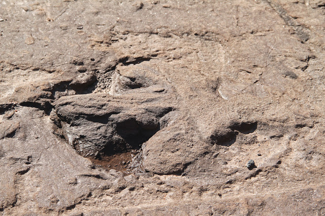
This fossil of Eurypterus remipes, over 400 million years old, is entombed within a dolostone slab
of the Phelps Waterlime. It is presumed (notice the telltale bend in the tail or telson, the body out of axial alignment and the damaged carapace) to be a molted exoskeleton (or exuvia) rather than a preserved carcass, as most are. Its segmentation and body divisions are well defined from its trapezoidal carapace to its pointed telson, as are its compound eyes and swimming paddles. Missing from view are the remaining appendages, six pairs in all.
(Photographed at the R.H. Langheinrich Museum of Paleontology)

Looking like a mix between a scorpion and a lobster on steroids, the extinct eurypterid (you-RIP-ter-id)  or “sea scorpion” was the largest known arthropod, an immense and diverse menagerie of both aquatic and terrestrial invertebrate animals that also includes insects, lobsters, crabs, centipedes, scorpions, spiders and mites. Eurypterids were not true scorpions, although they not only share a profound resemblance and evolutionary relationship to scorpions (both are members of Phylum Arthropoda and Subphylum Chelicerata), they also share aquatic paleoecologies having co-existed together. 


SEA SCORPIONS OF THE SILURIANSEA
Eurypterids were named from the Greek words for “wide wing” or “broad paddle” referring to the pair of large swimming appendages located on either side of their head structures. The species desgination of the state fossil "remipes" is from Latin meaning "oar" and "foot." They are thought to have lived an aquatic existence in warm, shallow, marginal marine environments in the Middle Paleozoic, and mainly lacustrine, fluvial, and estuarine environments later in the Late Paleozoic. Based on the evaporitic content of the waterlimes in which they are more commonly found (in eastern North America), it is also thought that they exhibited a certain salinity tolerance.

Their apparent dual respiratory system (four pairs of book gills housed within branchial chambers) have led some paleontologists to suggest that eurypterids made forays onto land, an evolutionary transition that many arthropods ultimately made. 

Although eurypterids are extinct, they are morphologically well known owing to the large numbers of exquisitely preserved specimens. However, many aspects of their biology and ecology remain somewhat speculative, clouded by a preservational and collection bias, as happens when making assumptions on ancient fossilized remains.

Eurypterid genera of New York State (clockwise from upper left): 
Dolichopterus, Stylonurus, Eurypterus, Hughmilleria, Eusarcus and Pterygotus
 (By the famous paleontological illustrator Charles R. Knight from Clarke and Ruedemann, 1912)


EARLY BEGINNINGS TO END PERMIAN EXTINCTION
Earliest arthropods...
Arthropods, the phylum to which eurypterids belong, are thought to have evolved from annelids (segmented worms) 500 to 600 million years ago, although several members of the Neoproterozoic Ediacara biota may represent the earliest ancestors. Arthropods have remained the dominant component of animal species diversity beginning with their earliest recognition in the Early Cambrian. Facilitated by walking on their jointed appendages, a myriapod arthropod of the centipede-millipede family made the first pioneering steps onto land during the Silurian between 490 and 443 million years ago.

Earliest chelicerates...
The earliest chelicerate, an arthropod subphylum, was possibly Sanctacaris or “saintly crab” after the latinized version of Santa Claws. It was discovered in 1981 in a Burgess Shale-type locality near the famous Walcott Quarry high in the Canadian Rockies. Chelicerates are thought to have given rise to eurypterids, scorpions, horseshoe crabs, mites and spiders. Fossils such as Sanctacaris provided the basis for interpreting the origins of the living arthropods within the Cambrian radiation. Both members of Phylum Arthropoda and Subphylum Chelicerata, the Middle Cambrian Sanctacaris (left) and the Late Silurian eurypterid (right) are separated by about 100 million years of evolution.

Notice the similarities of the two chelicerates. In particular, Santacaris (left) and a eurypterid (right) both possess a head shield with its six pairs of appendages beginning with a distinctive chelicerae.
(Modified from Wikipedia and John Augier)

Sanctacaris exhibits the characteristics that clearly identify it as both an arthropod and a chelicerate particularly the distinctive grasping-appendages near its mouthpart. Called a chelicerate appendage, this structure both defines and names the subphylum as a group. Evolutionary variations of the appendage also morphed it into a specialized claw. More on that later.

Earliest eurypterids...
The earliest known eurypterids were from the Early Ordovician of Wales, and by the by the Late Ordovician, eurypterids were present in shallow marine settings of Laurentia. By the Silurian and Devonian they were mainly from sediments in restricted, near-shore marine environments such as the “Bertie waterlime” in New YorkState. We’ll visit such a locality later in the following post (Part II). Eurypterids went extinct during the Permian-Triassic extinction event 251 million years ago along with 96% of all known marine life. Represented by perhaps 241 species (possibly a somewhat inflated number), eurypterids are relatively rare fossils worldwide, partly due to their unmineralized exoskeletons.


THE DEFINING STRUCTURES OF ALL ARTHROPODS
Arthropods (Greek meaning “joint” and “foot”) are invertebrates (lacking a backbone) and are characterized by a body plan consisting of repeating segments (grouped into modular body divisions called tagma), bilateral (left-right) symmetry, jointed, tubular appendages (a tremendous competitive innovation), and a rigid-yet-flexible chitinous exoskeleton (external rather than internal and secreted by the cuticle).

This lobster (Subphylum Crustacea) is a typical arthropod.
(From bio1152.nicerweb.com)
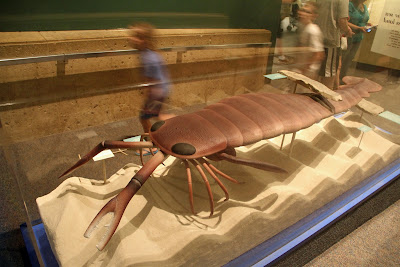
Our extinct eurypterid (Subphylum Chelicerata) has all the characteristics of the arthropod that it is.
(A model from the Smithsonian National Museum of Natural History’s Hall of Fossils)


A BODY DIVIDED SHALL NOT FALL
The repeating body segments of arthropods, called metamers, are grouped into modules called tagma (Greek for a military unit) in which segments became fused and specialized in a plethora of ways. Metamerism had its origins not only within Phylum Arthropoda, but with Annelida (segmented worms) and Chordata (animals with a backbone, vertebrates like you and I). It conferred competitive advantages by allowing greater complexity in structure and function such as allowing the independent movement of separate body segments.

Arthropods are highly compartmentalized, divided tagmatically into a front, middle and rear section. For example, insects and crustaceans possess 3-tagma: a head, thorax and abdomen (some with cephalothorax and abdomen). Trilobites (extinct) also possessed 3-tagma: a cephalon, thorax and pygidium (tail). Eurypterids (such as Pterygotus from Lang's Quarry seen below) possessed 2-tagma: a prosoma (fused head and thorax) and opisthosoma (abdomen) with its abdomen in turn divided into mesosoma and metasoma.


This ventral view of the specimen Eurypterus remipes, identified as a member of the Eurypterina Superfamily by the swimming paddles (the sixth appendage), is again a molted exoskeleton. Dolichopterus of the same superfamily and also of the Bertie Waterlime looks similar in appearance but with larger eyes and a somewhat flattened penultimate appendage (the fifth appendage).
(Photographed at the R.A.LangheinrichMuseum of Paleontology)

OUT ON A LIMB
The appendages of arthropods became specialized as well. At first, unspecialized segments bore a pair of appendages or “legs”, one on each side of the body and one pair per body segment. Each pair of appendages consisted of two branches, an outer branch (“gill” branch) for respiration in water and an inner branch (“leg” branch) for locomotion. The entire structure is called a biramal limb meaning “two branched.”
This conceptualized biramal limb consists of a gill- and a leg-branch.
(Modified from Wikipedia)
The spider-like diagram is a conceptualized single body segment of a multi-segmented marine arthropod. The biramal appendage attached to the base of the segment has a pair of gill- and leg-branches. As arthropods evolved and body segments became fused into modular tagma, gill- and leg-branches also became modified, specialized or even lost. Leg-branches became specialized for walking and with paddles for swimming. Pincers and stingers evolved for defense, antennae for sensing the environment, and graspers for acquiring and manipulating a meal. Marine arthropods lost their gill-branches (becoming uniramal) when they became terrestrial, losing the need for gills on land.


THE DEFINING STRUCTURES OF THE CHELICERATES AND OUR EURYPTERIDS
Eurypterids, being members of Phylum Arthropoda, are members of the Subphylum Chelicerata. Chelicerates have all the aforementioned arthropod characteristics in addition to a chelicera (Greek for “claw horn”), the only appendage anterior to the mouth. Their preoral appendage evolved into a specialized mouthpart from a leg-branch for cutting, chewing, piercing, sucking, siphoning, grasping and filtering, all aimed at directing a meal to the mouth. In the eurypterid, the chelicera functions in grasping and is the first of six pairs of appendages (designated by Roman numerals and with a pair for each segment) arranged in a radiating-array around the mouth, a highly efficient predatorial morphology.

Chelicerates are defined by their "jaws" called chelicerae, which also give the group its name (red). In spiders, the chelicerae function as fangs. In horseshoe crabs and eurypterids, the chelicerae serve as graspers of food. Chelicerates lack antennae, but insects have them, actually modified from the first appendage that forms the chelicerate's mouthparts. Being arthropods but not chelicerates, therefore, insects feel with the first pair of limbs on their heads, and chelicerates grasp and bite with them. The pedipalps (blue) are the second appendage. (paleontologyonline.com by Jason A. Dunlop)
The second pair of appendages are called pedipalps and are usually sensory in function (homologous with mandibles in crustaceans and insects). The last four pairs of appendages are for purposes of locomotion, also  evolved from leg-branches, but the sixth appendage became specialized as a paddle for swimming. Note that no antennae are present within the group such as developed in crustaceans and insects.

The chelicera of eurypterids is usually small and generally poorly preserved in fossils. But in pterygotids, it is greatly enlarged, having evolved into long, prehensile claws for the capture of prey.
(By Karen Carr)

EURYPTERID ANATOMY 101
Putting it all together, a typical eurypterid possessed a large, flat, semicircular head (prosoma) protected by a dorsal head-shield (carapace), highly reminiscent of horseshoe crabs (also a chelicerate but member of Order Xiphosura rather than Order Eurypterida). On the dorsal surface, the prosoma housed two pairs of eyes, a large compound pair (consisting of many small photoreceptors) and a smaller, light-sensitive, median pair (ocelli) with an uncertain functionality. On the ventral surface, six pairs of jointed appendages (walking and swimming legs), each arising from a body segment surrounded the mouth.

The abdomen (opisthoma) possessed respiratory book gills, reproductive organs (eurypterids were sexually dimorphic but with one sex which is thought to be differentiated by female horn organs for sperm storage and male claspers), and was armored with tergites dorsally and sternites ventrally. The eurypterid’s scorpion-like tail (telson) facilitated in swimming, but it is not inconceivable that it may have borne venomous glands similar to modern terrestrial scorpions. Got predator?  


A eurypterid (dorsal top and ventral bottom)
(From Wikipedia.com)

HOW DO EURYPTERIDS FIT INTO THE ARTHROPOD FAMILY TREE?
Based on morphological structures, ancestry and molecular data, many schemes of arthropod and chelicerate classification exist with a profusion of names (often synonymous and polyphyletic), the subject of ongoing debate, persistent re-analysis, countless revisions and lack of universal agreement. The following arthropod  phylogeny (chart below) was derived by nuclear protein-coding sequences (Napier, 2010).
 
For purposes of our simplistic discussion, let’s divide Phylum Arthropoda into five basic groups or subphyla (one of which is extinct), not being overly concerned with phylogenetic relationships. We have:
     1.) Myriapods (centipedes and millipedes)
     2.) Trilobites (extinct Paleozoic marine bottom-dwellers)
     3.) Chelicerates (spiders, mites, horseshoe crabs, scorpions and extinct eurypterids)
     4.) Crustaceans (lobsters, crabs, shrimp, barnacles, brine shrimp and others)
     5.) Hexapods (insects)

Much can be said, but let it suffice to say that eurypterids and arachnids (scorpions, spiders, mites and ticks) are considered sister taxons, sharing a common chelicerate ancestry with xiphosurans (horseshoe crabs). As we shall see (post Part II), eurypterids and scorpions also share a common ecology amongst specimens found at Lang’s Quarry.


EURYPTERID ORIGINATION AND GLOBAL DISPERSAL
The earliest known eurypterid is from Wales (Late Ordovician ~460 Ma), while those last preserved near the Permian extinction are from Russia (Late Permian ~250 Ma). During their total range of about 210 Ma, eurypterid fossils are found not only in New York, but in countries as diverse as China, Germany, Norway, Spain, Great Britain, Canada, Siberia, Brazil, Argentina, Bolivia, Libya, South Africa, Vietnam and the Baltic region. Where did eurypterids originate? How and when did they become dispersed throughout the globe?

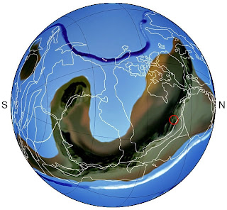
I have indicated (red dots) the countries and approximate locations of eurypterid fossil discoveries on the globe during the Late Cretaceous (94 Ma). With the origination of Eurypterus eurypterids, first perhaps from Baltica, their subsequent invasion of eastern Laurentia, and their ultimate dispersal throughout the globe, one can predict the geographic locality of potential eurypterid future discoveries. For Eurypterus, furthering our knowledge will rely on focusing on the countries derived from the terranes of Laurentia, Avalonia, Baltica and the Rheno-Hercynian (Tetlie, 2007).
(Modified from scotese.com)
It has long been known that almost all eurypterids originated mostly from marginal marine settings of the Paleozoic continent of Laurentia, but also at a time when Laurentia, Avalonia, Baltica and the Rheno-Hercynian terrane were in close proximity tectonically (Tetlie, 2007). Following Pangaea’s dissociation, eurypterids were distributed globally throughout the various countries represented above while being “rafted” on the continents on which they lived. As a result, we find similar Late Silurian ecosystems (and eurypterids) in New York State separated by the Atlantic Ocean from similar ecosystems in Wales, Scotland and Norway.

The ancestors of Eurypterus remipes appear to have first originated in Baltica and later invaded Laurentia (recall that Baltica collided with Laurentia during the Acadian Orogeny). Their origination, invasion of Laurentia and global dispersal lies in a tectonic explanation. Differences in geographic origination exist amongst the various other clades of eurypterids.

This tectonic "big picture" of the Late Silurian (~420 Ma) shows the Taconic island-arc having collided with Laurentia and having formed a mountain chain and foreland basin. Baltica (to the north) and its associated fused terranes of Avalonia are amalgamating with Lauentia. Later, Avalonia will fuse with Laurentia to form Laurussia, and even later Gondwana will have its turn. The ancestors of E. remipes are thought to have invaded Laurentia from Baltica. (Modified from Ron Blakey, NAU Geology) 
In addition to tectonics as an explanation for their global distribution, could eurypterids have navigated the open seas and populated continents afar? Interestingly, a morphological explanation for their distribution may exist (Tetlie, 2007). Eurypterids can be broadly divided into walking and swimming forms based on the morphology of the posteriormost prosomal appendage (revisit my Eurypterid Anatomy 101 section above for a review). One swimming-clade apparently reached its destination on Gondwana before it amalgamated with Pangaea implying that mode of locomotion was a factor in the clade’s dispersal.


EURYPTERID HABITAT DEVELOPMENT IN NEW YORKSTATE
Four orogenies, their foreland basins and clastic wedges
How might the aquatic habitat of eurypterids have evolved in New York State? Following the break-up of the supercontinent of Rodinia in the Neoproterozoic, its rifted continental siblings drifted throughout the globe, one of which was equatorially-situated Laurentia. Beginning in late Middle Ordovician time and extending through the Paleozoic, the closing of the Iapetus and RheicOceans signaled a nearly continuous succession of compressional tectonic regimes on Laurentia’s eastern margin with four convergence events: the Taconic, Salinic, Acadian and Alleghenian Orogenies. Each collision built mountains, contributed to the growth of Pangaea, and supplied vast quantities of sediment from the eroding mountain belts to the accommodation space of a succession of foreland basins (formed during lithospheric downflexure in response to orogenic crustal thickening).

In this Middle Ordovician paleomap (485 Ma), a Taconic island-arc complex
is on a tectonic collision-course with the passive eastern margin of Laurentia.
(Modified from Ron Blakey, NAU Geology)

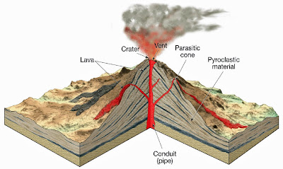
The Taconic Orogeny, the first of four
The Taconic Orogeny (late Middle Ordovician), a complex of island-arc terranes that collided with northeast Laurentia, resulted in the formation of a foreland basin referred to as the Queenston Delta in New York. This, first-of-many, deltaic complex marked the initiation of the Appalachian Basin that eventually extended from southern Quebec in Canada to northern Alabama. Sediments debouched into epeiric seas of the forelands forming an expansive clastic wedge that prograded cratonward and resulted in a complex mosaic of open, marginal marine and terrestrial facies. This scenario was basically repeated with each foreland of each successive orogeny to varying extents.

The scenario of orogenic collision, mountain range uplift and foreland basin formation with a prograding clastic wedge repeated through the Paleozoic on the eastern margin of Laurentia. In this diagram, the Taconic Orogeny, its foreland and the Queenston Delta are developing.
Another cross-sectional perspective of the lithospheric downflexure that formed the expansive Queenston Delta's clastic wedge and the mountainous front of the Taconic Highlands. Note the underlying Cambrian and Lower Ordovician basement structures from Laurentia's former passive slope and shelf.
  (Source unknown)

An unconformity at the Ordovician-Silurian boundary and a major extinction event coincided with global glaciation at the end of the Ordovician. Deglaciation resulted in the seas reinvading the land in the Silurian with a marine transgression. In New York, the Late Silurian is represented by the Salina and Bertie Groups that record an arid landscape with basins of intermittent high salinity. Access to marine seas of normal saline content was unavailable. A notable exception to the more sparse fauna were eurypterids that seemed to have led a prolific existence in the briny Late Silurian waters of the “Salina”, and in particular, the “Bertie” seas.

The Bertie waterlimes of the “Hypersaline Seaway”
As barriers developed that prevented open circulation to the sea, salinity increased enabling the precipitation of anhydrite, gypsum and halite at considerable thickness. The land-locked seas of the Late Silurian that prevailed over east Laurentia were reflected in the deposits of the Salina and Bertie Groups. This environment led to the development of a “hypersaline seaway” comparable to the Red Sea.

In New York the Bertie Group of carbonate sediments accumulated during the very late phases of Silurian deposition upon the Salina Group, both at or near sea level. Shared amongst their strata are fine, mud-cracked dolostones and evaporites indicative of restricted tidal flats to shallow lagoonal settings. Both groups, but particularly the Bertie, possessed stratigraphic members called “waterlimes,” a fine-grained, dolomitized mud (the name relates to their properties as natural cements that harden under water) that contain abundant eurypterid-bearing horizons, and associated fauna and flora. 

By their distinctive and abundant preservation within the hypersaline waterlimes, eurypterids are interpreted as being indigenous to these waters. But did they merely aggregate there in large numbers for purposes of molting and mating or were their remains washed into the region after death from nearby brackish or freshwater estuaries? Such are the challenges of reconstructing an ecology and biology from ancient fossiliferous remains. 

Eurypterids were most diverse between the Middle Silurian and Early Devonian with their absolute peak of diversity in the latest Silurian. The Silurian closed with normal marine conditions returning to northeastern Laurentia, and along with it, a normal marine faunal and floral representation.


Silurian age rocks preserved at the surface throughout New York State
(From paleoportal.org)

IN CONCLUSION
In this post (Part I), we investigated the basic morphology, evolution and phylogeny of eurypterids, their origination and dispersal throughout the globe, and the tectonic formation of their habitat in the State of New York. In the following post (Part II), we'll hunt for fossil eurypterids at the Lang Quarry and visit the R.A. Langheinrich Museum of Paleontology.


SUGGESTED READING
Distribution and Dispersal History of Eurypterida (Chelicerata) by O. Erik Tetlie, 2007.
Testing the Mass-Moult-Mate Hypothesis of Eurypterid Paleoecology by Matthew B. Vrazo and Simon Braddy, 2011.
The Eurypterida of New York VI by Clarke and Ruedemann, 1912.
The Rise and Fall of the Taconic Mountains by Donald Fisher, 2006.
Geology of New York by Y.W. Isaachsen et al, 2000.
The Trilobites of New York by Thomas E. Whiteley, 2002.
Eurypterids Illustrated by Samuel J. Ciurca, Jr., 2008-2010.
Fieldtrip Guidebook, NYS Geological Association, Fiftieth Annual Meeting (1978), Fifty-fourth (1982), Sixty-second (1990), Sixty-sixth (1994) for publications by Samuel J. Ciurca, Jr.
Wonderful Life by Stephen Jay Gould, 1989.


SUGGESTED WEBSITES
eurypterid.net and eurypterids.net/EurypteridLinkIndex.html by Samuel J. Ciurca, Jr.
statefossil.org/news.htm by Allan and Iris Lang
cpgeosystems.com/nam.html by Ron Blakey


ACKNOWLEDGEMENTS
I wish to thank Allan and Iris Lang for their time and generosity in making their collection at the museum available for viewing and photography. I also want to thank Allan for his private tour of the quarry. The Lang facility is open to the public by appointment only. Contact information is available on their website.


Many thanks also to paleontologist Samuel J. Ciurca, Jr. of Rochester, New York for his personal communications. Sam has been studying, collecting, meticulously documenting, and publishing on eurypterids (and associated flora and fauna) for over 50 years. He has donated thousands of specimens from his personal collection to institutions such as the Yale Peabody Museum’s Division of Invertebrate Paleontology recognized as the Ciurca Collection, the Smithsonian Institution and the Buffalo Museum of Science.


Memorable Places Here and There on the Colorado Plateau: The Granite Gorge of the Grand Canyon

$
0
0

Sometimes one photo says it all.


Clear Creek Trail ascends abruptly from Phantom Ranch at the bottom of the Grand Canyon. The trail guides you through a series of switchbacks and climbs almost a thousand feet before leveling off. As it skirts around rocky corners of the Tonto Platform, it traces the undulating line of the Great Unconformity between the half-billion year old Tapeats Sandstone and the nearly two billion year old Vishnu Schist.

You’re following an enigmatic billion year gap in time along the contour of ancient islands that projected out from the Panthalassic sea. Incredible views of the Colorado River abound as it slices through the Granite Gorge far below.

Eventually, you reach the lofty perch where this photo was taken. You must to sit down. It’s the best seat in the house. All you hear is the warm hum of the wind and the faint murmur of the rapids far below. You never want to leave, and you never will, for it will always be with you.  
  

The Eurypterid “Eurypterus remipes” is the Official Fossil of the State of New York: Part II - Fossil Hunting at Lang’s Quarry of Passage Gulf

$
0
0

Interested in details of eurypterid anatomy, evolution and tectonics? Who isn't! Please visit my recent post. Here’s the link: http://written-in-stone-seen-through-my-lens.blogspot.com/2012/05/eurypterus-remipes-official-fossil-of.html

In 1984, Eurypterus remipes was designated the official fossil of the State of New York, a fitting choice since the majority of the prolific eurypterid-bearing regions of the world are found within the state’s borders.

This ventral view of a eurypterid displays its major body divisions, segmentation, spinose walking legs
and distinctive swimming paddles. Even the minute serrations on its lance-like telson are exquisitely preserved. The fossil is likely a molted exoskeleton rather than a carcass, as the majority likely are.
(Photographed at the R.A.LangheinrichMuseum)

SALACIOUS SEA SCORPIONS OF THE SILURIANSEA
Eurypterids are commonly known as “sea scorpions” due to their striking resemblance to terrestrial scorpions, not surprising since the two belong to phylogenetically-related sister groups (Eurypterida and Arachnida). Eurypterids were marine members of the arthropod phylum from the Early Ordovician through their ultimate demise during the great Permian extinction with their heyday during the Silurian.

(Source unknown)

Eurypterids were not only the largest arthropods but thought to represent some of the earliest animals to undertake brief amphibious excursions onto land (Selden, 1985; Braddy, 2001). Their arthropodal body architecture made them pre-adapted for adventuring landward with exoskeletons that provided support and water conservation capabilities, flexible legs for walking on land and a respiratory system adaptable to breathing air. Eurypterids never transitioned to a fully land-based lifestyle having gone extinct 250 million years ago, but their phylogenetic relatives certainly did, the closest of which are arachnids (scorpions, spiders, ticks and mites).

About 420 million years, plants such as Cooksonia began their conquest of the land, followed soon by animals such as eurypterids. They were opportunists in that they took advantage of what they already had, body parts and behavior adapted to an aquatic existence but useful on land as well.
(Model on display in Smithsonian Institution’s Natural History Museum)

Phylum Arthropoda > Subphylum Chelicerata > CLASS MEROSTOMATA > ORDER Eurypterida
Examples of arthropods include insects, horseshoe crabs, lobsters, crabs, centipedes, scorpions, spiders and mites. All are invertebrates (without a backbone) and possess a compartmentalized body (that is segmented), tubular jointed-appendages (a tremendous evolutionary novelty) and a rigid exoskeleton (for protection).

These innovations allowed arthropods to populate almost every ecological nook and cranny on Earth in immense numbers. Some 80% of all known animal species are arthropods, mostly insects. That led the Harvard paleontologist Stephen Jay Gould in Wonderful Life to refer to the Cenozoic Era as the “Age of Arthropods” rather than the egocentric “Age of Mammals.”

Eurypterids were also chelicerates, an arthropod subphylum, along with horseshoe crabs, spiders, mites and scorpions, named as such for the chelicera, the distinctive first appendage in front of the mouth. Arachnids, the chelicerate sister group, includes spiders, scorpions, ticks and mites.

IT’S ALL TAPHONYMOUS TO ME
The general public has the perception that fossils are extremely rare. They don’t know where to look for them (except within a display case or a "dusty" museum) or even what they look like when found. But as we all know, fossils are extremely common. The preservation of past life, which is what fossils are, requires a convergence of opportune circumstances that allows their rocky interment. The process of their preservation is called “taphonomy.”

Biomineralized bones and shells are favored for perpetuation over fragile soft tissues, as are large bones over smaller ones. Rapid burial increases the chances of preservation from bacterial decomposition, tissue degradation, scattering and scavenging. Diagenesis and pyritization enhances the fossilization of delicate structures. If the taphonomy is favorable, the fossil record provides us with a “story of the past that is written in stone.”

LAGER WHAT?
Under the best of circumstances, only 15% of plants and animals become immortalized as fossils. In 1859, Charles Darwin made this observation in Chapter 9 of On the Origin of Species entitled “On the Imperfection of the Fossil Record.” Darwin was concerned that its imperfection would discredit his theory of evolution.

On special occasions the fossil record may present us with an astounding and rare gift. Fortuitous circumstances may allow the preservation of fossils in either vast numbers or exceptional quality, or both. Paleontologists call such a taphonymous discovery “lagerstätten”, a German word meaning “storage place.” Think of it as a fossil-mother lode.

THE LAGERSTÄTTEN OF NEW YORK
There are many fossil lagerstätten scattered around the world. In New YorkState there are three. One is the “Bertie Waterlime” special for its abundance of eurypterids. Two are nearby to the east: the Middle Ordovician Walcott-Rust Quarry (about 485 Ma) and the Late Ordovician Beecher’s Trilobite Bed (about 445 Ma), both renowned for their remarkable preservation of trilobites, also extinct arthropods of the Paleozoic seas. 

A Pterygotid eurypterid grasping its next meal
(Source unknown)

THE “BERTIE WATERLIMES”
By the Late Ordovician, eurypterids were present in shallow marine settings in Laurentia (see my post Part I for a tectonic explanation). By the Silurian and into the Devonian, they were thriving in restricted, near-shore environments primarily within the “Bertie Waterlimes.” Waterlime is an industrial rather than a geological term, so called because of its ability to set as a cement under water.

Waterlimes are deposits found in New YorkState within the Salina Group and largely within the overlying Bertie Group. Their deposits are characteristic of shallow-water basins with a restricted circulation and typical of the arid climate of the New York region of Laurentia during the Late Silurian at about 30°south of the equator. The eurypterid-bearing sequences of the waterlimes crop out along a long swatch of Late Silurian to Early Devonian real estate from eastern Central New York somewhat into Canada.

The Bertie Group (the type locality is a Canadian township) is a carbonate sequence of dolostones and limestones with minor shale and mudstone units, evaporites (of gypsum, halite and anhydrite) and intercalated waterlimes that accumulated during multiple oscillations of the Silurian seas. Amongst the numerous waterlime horizons that exist within the Bertie, several species of eurypterid remains have been recovered predominantly within the Phelps Waterlime Member (notably E. remipes) of the Fiddlers Green Formation (a major transgressive-regressive cycle) and the earlier Williamsville Formation (notably E. lacustris) of western New York and the Niagara Peninsula of Ontario, Canada. Eurypterids are also found in southeastern New York within the localized Shawangunk Formation. Unconformably overlying the Bertie Group are Lower Devonian eurypterid-bearing carbonates (of genus Erieopterus).

Eight different onshore to offshore paleo-environments are recognized within the Bertie Group including sabkha, hypersaline lakes, assorted tidal, lagoon and estuarine (Hamell, 1985).

Late Silurian Salina and Bertie Groups (light gray on upper inset) form an outcrop belt that extends from east Central New York across the state to Buffalo and into the Niagara Peninsula of Ontario, Canada. The PassageGulf locality is situated at the outcrop’s easternmost extent (stratigraphy lower right). Within the Bertie Group, the productive eurypterid-bearing waterlime is the Phelps Member of the Fiddlers Green Formation.
 (Modified from Tetlie et al, 2007)

PASSAGE
GULF
Nestled along the Mohawk River and the famous Erie Canal that flow eastward across the state is the sleepy eastern Central New York town of Ilion. A stone’s throw from town in the hills to the south amongst picturesque pastures and woodlands is a nondescript 1950’s roadcut known as PassageGulf whose singularity is easy to overlook.

PassageGulf’s main attraction are the exquisite eurypterid fossils preserved within exposures of the Phelps Waterlime at its eastern extent. Heading west across the state, the waterlimes crop out in roadcuts, ravines, creek beds, canal beds, building excavations and quarries, exposing eurypterid material that is there if you’ve got the patience and skill to find it. A master at his trade, paleontologist Sam J. Ciurca, Jr. has been doing just that for over 50 years and mapping the stratigraphy as well.

Sam J. Ciurca, Jr. in 1965 with a four-foot ‘monster’ Pterygotid (Acutiramus macrophthalmus)
(From eurypterids.net and Eurypterids Illustrated)

EURYPTERID FOSSIL HUNTING AT LANG'S QUARRY
Within sight of PassageGulf is Lang’s Quarry. Allan and Iris Lang have been excavating, preparing and displaying eurypterids, lecturing to and hosting school groups, paleontological societies and scientific institutions both locally and from around the world since their establishment was founded in 1984.

On a crisp, sunny April day, Allan Lang gave me a private tour of his quarry. With me bouncing around on the back of his all-terrain vehicle, we sped off climbing the well-worn, gravelly dirt trail behind the museum. As we ascended the slope, deer clambered left and right to get out of our way. In under a minute we were in the quarry. Allan enthusiastically explained his modus operandi for retrieving fossil eurypterids, an arduous and patience-testing task that he’s been performing with a labor of love for almost 30 years.

After several feet of overburden consisting of unconsolidated Pleistocene glacial till and topsoil have been removed, heavy earth-moving equipment is used to exhume the underlying Fiddler’s Green Formation. The target is the 1 to 1.5 meter thick, fossil-bearing waterlime of the Phelps Member. The excavated rock face in the photo provides a scale of the excavating operation.


Rather than hack away at the dense dolostone by hand, a laborious and time-consuming process, extracted large blocks are allowed to weather a series of harsh Central New York winters (of which I can testify to having grown up in nearby Syracuse). Assisted by winter’s repetitive freezing and thawing, the rock tends to readily cleave along frost planes that have developed.


Once the rock has fully weathered, the seasoned waterlime is ready. Notice the two “foreign” boulders of glacial erratic amongst the talus of waterlime. Allan is hard at work doing what he both loves and knows best.


Allan instructs that by aligning a hammer and chisel at the right angle within a frost plane and followed by a lot of pounding the dolostone will split apart. Notice the fine-grained, layered nature of the waterlime’s limy muds.


Finally, a firm, two-handed pull lifts the heavy, newly exfoliated façade and exposes the treasures that have been trapped for over 400 million years. Seeing my enthusiasm, Allan cautioned that typically hundreds of slabs must be split apart in order to find one good eurypterid. Unknowingly, I was about to defy those odds.

Call it beginner’s luck, but on my first attempt I uncovered a massive, foot-long claw from the eurypterid Pterygotus! This was the portion of the claw attached to the head structure, referred to as a fixed ramus, whereas the movable grasping-end is the free ramus. Together they clamp down on the eurypterid’s prey similar to a lobster-claw. Based on the size of the claw, my guess for the Pterygotus was 6-8 feet in length.

Still partially buried within the matrix of the waterlime, the claw’s massive teeth are readily discernible.


 (Modified from an illustration by William L. Parsons, BuffaloMuseum of Science)

On my second slab-splitting attempt, I uncovered two small molts of Eurypterus eurypterids. Allan marks noteworthy fossils with yellow chalk. They will eventually be transported down to his lab where they are carefully excised from the matrix of the waterlime, cleaned and professionally prepared with micro-air abrasion, a laborious and skill-requiring process.


Notice the conchoidal fractures in the waterlime that cleaves similar to a broken soda bottle. Allan refers to their appearance as “dishes.” Conchoidal fractures transect more than one bedding plane and often contain eurypterid fossils. In all, we sectioned three or four slabs.


This is a close-up of the newly-exposed veneer of waterlime seen above. Seen from the ventral aspect, two Eurypterus remipes are seeing the light of day for the better part of 415 million years.   


After my rewarding visit to the quarry, we headed back down to the museum. I was anxious to see what surprises Allan had unearthed over the years. Please see my next post Part III – The R.A. Langheinrich Museum of Paleontology.


LANG’S QUARRY AND THE R.A.LANGHEINRICHMUSEUM OF PALEONTOLOGY
The Lang’s facility is open by appointment only. Contact information is available on their website. 

SUGGESTED READING
Distribution and Dispersal History of Eurypterida (Chelicerata) by O. Erik Tetlie, 2007.
Testing the Mass-Moult-Mate Hypothesis of Eurypterid Paleoecology by Matthew B. Vrazo and Simon Braddy, 2011.
The Eurypterida of New York VI by Clarke and Ruedemann, 1912.
The Rise and Fall of the Taconic Mountains
by Donald Fisher, 2006.
Geology of New York by Y.W. Isaachsen et al, 2000.
The Trilobites of New York
by Thomas E. Whiteley, 2002.
Eurypterids Illustrated by Samuel J. Ciurca, Jr., 2008-2010.
Fieldtrip Guidebook, NYS Geological Association, Fiftieth Annual Meeting (1978), Fifty-fourth (1982), Sixty-second (1990), Sixty-sixth (1994) for publications by Samuel J. Ciurca, Jr.

SUGGESTED WEBSITES
Eurypterid.net and eurypterids.net/EurypteridLinkIndex.html by Samuel J. Ciurca, Jr.
Statefossil.org/news.htm by Allan and Iris Lang

ACKNOWLEDGEMENTS
I wish to thank Allan and Iris Lang for their time and generosity in making their incredible collection at the museum available for viewing and photography. I also want to thank Allan for his private tour of the quarry.

Many thanks also to paleontologist Samuel J. Ciurca, Jr. of Rochester, New York for his personal communications. Sam has been studying, collecting, meticulously documenting and publishing on eurypterids, their associated flora and fauna, and the entombing stratigraphy for over 50 years. He has donated thousands of specimens from his personal collection to institutions such as the YalePeabodyMuseum’s Division of Invertebrate Paleontology recognized as the Ciurca Collection, the Smithsonian Institution and the Buffalo Museum of Science.

The Eurypterid “Eurypterus remipes” is the Official Fossil of the State of New York: Part III – The R.A. Langheinrich Museum of Paleontology in Eastern Central New York

$
0
0

The honor of “Official Fossil of the State of New York” was bestowed upon Eurypterus remipes in 1984, attributable to its abundance within the state’s borders. Now extinct, eurypterids were marine arthropods that bore a striking resemblance to contemporary scorpions, evolutionary relatives classified within a sister taxon. “Sea scorpions,” as they are affectionately called, reached their heyday of diversity during the Silurian Period and their demise during the Great Dying of the Permian along with 96% of marine species. In spite of their wealth of preservation within the state, eurypterid paleobiology, ecology and environments have remained a source of conjecture and speculation.

Many of this eurypterid’s spinose appendages are missing, the integument of the carapace has partially flaked off and the telson is almost severed, all possibly due to disarticulation, transportation and burial. This fossil measures about four inches, whereas members of the species are thought to reach two feet. Of the six pairs of grasping, walking and swimming appendages (legs), five pairs are visible.
(From my personal collection from Lang’s Quarry)

THREE POSTS ON EURYPTERIDS
In my first post (Part I), I discussed basic evolution, phylogeny, morphology and tectonics of the eurypterids of New York (http://written-in-stone-seen-through-my-lens.blogspot.com/2012/05/eurypterus-remipes-official-fossil-of.html).

In my previous post (Part II), I received a private tour of the Lang Quarry, located just south of Ilion in HerkimerCounty of eastern Central New York at a famous outcrop known as PassageGulf. Eurypterids are found within the thinly stratified, limy muds of the quarry's waterlimes (http://written-in-stone-seen-through-my-lens.blogspot.com/2012/06/eurypterid-eurypterus-remipes-is.html.

In this final post on eurypterids (Part III), I headed to the nearby R.A.LangheinrichMuseum, the repository for almost three decades of excavating, preparing and studying eurypterids by Allan Lang, its owner and curator.


Dorsal and ventral aspects of Eurypterus tetragonophthalmus from Jan Nieszkowski's 1858 dissertation
(From wikidedia.com)

THE R.A. LANGENHEINRICH MUSEUM OF PALEONTOLOGY
Allan and Iris Lang maintain the R.A. Langheinrich Museum of Paleontology (Allan’s more-difficult-to-pronounce official surname). The museum not only includes an incredible assortment of eurypterids from the quarry but Allan’s enormous collection of meteorites from around the world. Allan is a skilled metal worker, and many of the meteorites have been sliced into thin sections for viewing.

Allan (below) is proudly posing with a cast of a gigantic Pterygotus (Acutiramus). The over seven foot tall fossil is actually a composite that was assembled from three slabs of dolostone from the Lang Quarry and is the largest of its kind ever found. The original resides as the centerpiece of the RoyalOntarioMuseum’s paleontological exhibit.

Allan Lang and the massive Pterygotus that he excavated from his quarry
(Photographed at the R.A.LangheinrichMuseum of Paleontology)

For size comparison notice two small eurypterids and the disarticulated carapace (head structure) alongside the composite. Gigantism reflected in Middle Paleozoic marine eurypterids such as Pterygotus was a foreshadowing of the enormous size that existed amongst Late Paleozoic terrestrial arthropods such as "monster millipedes, colossal cockroaches and jumbo dragonflies" (Braddy, 2007).

Giant arthropods from the fossil record compared with average height of a human male (British):
(a) the eurypterid Jaekelopterus rhenaniae, Early Devonian, Germany; (b) the trilobite Isotelus rex, Late Ordovician, Manitoba, Canada; (c) the dragonfly Meganeura monyi, Late Carboniferous, France; (d) the millipede Arthropleuro armata, Late Carboniferous, Europe. Scale bar (a-d), 50 cm.
(From Braddy, 2007)

Model of a gigantic, yet life-sized Pterygotus eurypterid
(Smithsonian Institution’s Museum of Natural History.

The eurypterids of PassageGulf
The eurypterids of New York were originally thought to be preserved within two “pools” which are now considered to be distinct stratigraphic horizons. The eurypterids listed below were considered representative of the “Herkimer pool” (from HerkimerCounty) of New York, the eastern locality such as PassageGulf. Eurypterids found in western localities of the “Buffalo pool” include Hughmilleria, Paracarcinosoma and Eurypterids such as lacustris:

The three eurypterid families most commonly found at Lang’s Quarry of Passage Gulf:
 1.) Pterygotus possessed narrow, spine-less walking legs, a rounded-trapezoidal head (carapace) with compound eyes near its margin, a flattened and expanded tail (telson) with a dorsal-keel down the midline, and most notably, a pair of large chelicerae claws in front of the mouth fortified by the presence of large, well-developed teeth. Its size ranged from a few inches to well over 3 feet with gigantic specimens exceeding 7 feet. Based on partial remains, Pterygotids likely exceeded 10 feet in length. An example is Acutiramus macrophthalmus

2.) Eurypterus, the most common eurypterid of the Fiddlers Green Formation, comprising 90-95% of the Bertie Group eurypterids, possessed spinose appendages, more centrally-located eyes, a pointed tail and larger swimming paddles. Its size ranged from under an inch to a foot or two in length. An example is Eurypterus remipes

3.) Dolichopterus had compound eyes located near the edge of its prosoma, stout spinose-walking legs, swimming legs with serrated margins, a somewhat flattened carapace, lateral projections on its abdominal segments and a lance-like tail. Its size ranged from under an inch to about one foot. An example is Dolichopterus jewetti

Pterygotus, Eurypterus and Dolichopterus
(Modified from Ernst Haeckel’s Kunstformen der Natur, 1904)

THE BERTIE BIOTA
The Late Silurian Bertie Group of New York, in particular its muddy dolostones called waterlimes, supported (or at least preserved) a rich eurypterid biota (see my two previous posts for details). Although the waterlime fauna and flora are considered to have been sparse, members of the marine paleocommunity in addition to eurypterids included horseshoe crabs, scorpions, phyllocarid crustaceans, a Lichid trilobite, gastropods, orthocone cephalopods, Lingulid brachiopods, ostracodes, graptolites, bryozoan corals, fish (rare in New York), stromatolites and other algal forms. Cooksonia, which grew in dense mats along the shoreline and considered to be amongst the earliest plant “pioneers” on land, has been recovered from waterlime deposits.

Cooksonia
(Photographed at the R.A.LangheinrichMuseum of Paleontology)
This model depicts a eurypterid venturing onto land with Cooksonia growing along the shoreline.
(Smithsonian Institution’s Museum of Natural History)

SHEDDING ONE’S CHITINOUS SKIN
This slab of waterlime displayed in the museum contains a multitude of molted eurypterids and a disarticulated carapace. In fact, most eurypterid fossils are presumed to be molted exoskeletons as opposed to carcasses (Braddy, 1995; Ciurca personal communication, 2012). The problem of distinguishing between eurypterid exuviae and carcasses has remained a paleontological exercise for almost a century (Clarke and Ruedemann, 1912; Tetlie, 2008). One of the challenges is that eurypterid exuviae, like horseshoe crabs, remain so intact defying inclinations to label them as molts.

Typical of all arthropods, eurypterids shed or molted their chitinous, semi-rigid exoskeletons in order to accommodate growth. Similar to cellulose in its supportive function, chitin is a modified polysaccharide like glucose that contains nitrogen. Contemporary horseshoe crabs (Xiphosurans) and scorpions (Arachnids) are frequently used, phylogenetically-related, modern-analogues for investigating aspects of eurypterid paleo-biology, ecology and behavior (Braddy, 2001; Tetlie 2008). Horseshoe crabs molt perhaps 10 times in its lifetime which provides some explanation for the vast numbers of preserved exoskeletons. 

Amongst the articulated eurypterid molts, notice the disarticulated carapace and the beautifully preserved spinose appendages. The chitinous exoskeletons have a brown color largely due to carbonization. The original components of the cuticle have undergone in situ polymerization during diagenesis (Gupta, 2007). The prevalence of "ventral-up" specimens is not necessarily an indication of supine-ecdysis (Tollerton, 1997) but may be related to transportation and burial (Tetlie, 2007).
(Photographed at the R.A.LangheinrichMuseum of Paleontology)

The actual shedding event is called ecdysis, whereas molting is the term reserved for the entire process that includes a period of inactivity both before and after ecdysis. Molting subjects arthropods to susceptibility from predation during the soft-shell stage. With horseshoe crabs, refugia are sought out, regions in which to safely molt. Reduction of suitable refugia near the end of the Silurian has been cited as a potential cause for eurypterid decline and extinction of some genera (Tetlie, 2007), although others site their decline to quicker, more heavily-armored fish prototypes that developed during the Devonian.

Recurrent patterns of disarticulation and telescoping of exoskeletal elements are some of the means used to distinguish fossil-exuvia from fossil-carcasses. Analyses of eurypterid exoskeletons, which at first appears to be a random dissociation, is in reality a non-random taphonomic pattern that suggests the underlying biological process of ecdysis (Tetlie, 2007).

Molting follows a sequence of events beginning when feeding and activity stops, and a tear develops in the anterior carapace margin. Eventually, the animal emerges from the molted exoskeleton (exuvia). Current thinking (Brady, 2001) considers the “Bertie” assemblages to consist predominantly of exuviae due to lack of scavenging, frequent crumpling, partial telescoping and dispersal of disarticulated remains.

WINDROWS
Eurypterid fossils frequently occur in linear aggregations called “windrows” (Ciurca). It is believed that this is an indication of current or storm-related transportation and orientation into the area of deposition (Tetlie and Ciurca, 2005). Hence, the entombing stratum is classified as a tempestite. Contemporary windrows of fragmentary, current-sorted bivalves, crabs and marine debris can be seen while strolling along the Atlantic shore after a tide or storm as seen below. These shoreline deposits ("strandlines") are segregated by weight and size (Ciurca personal communication, 2012). The waterlimes of New York are quite unusual and not your typical beach deposit. They are peculiar carbonates deposited in peculiar lagoons that researchers are still trying to understand today.


DEATH ASSEMBLAGES, MASS MOLTS OR BREEDING GROUNDS?
Displayed in the museum are two incredible mirror-image slabs of Bertie waterlime that contain a half-dozen articulated molts and sundry disarticulated bodyparts. Deceivingly, the two halves are not positive and negative casts of upper and lower members of strata entombing the fossils, but are “part” and “counterpart” slabs with each containing a portion of the preserved eurypterids. This is likely a small section of a windrow.

(Photographed at the R.A.LangheinrichMuseum of Paleontology)

One of the many questions surrounding eurypterids is whether large aggregations of molts are reflective of refugia or transportation from a freshwater estuary to a region of hypersaline waterlime for burial. Not surprisingly, other hypotheses exist. Based on fossil remains (which may falsely confer a taphonomic or collection bias), one theory suggests that “breeding grounds” were utilized in mudflats and sandbars for survival protection accounting for the large eurypterid assemblages (“mass molts”) or for ecdysis (“mass molts”) (Braddy, 2001). Mass mortality (“death assemblages”) seems less likely an explanation, since the remains are concentrations of exuviae rather than carcasses (Vrazo, 2011). As mentioned, possibly storms brought exuviae down river into muddy deltaic sediments near and offshore for burial, even additionally mixing with marine biotas (Ciurca, 2010). Horseshoe crabs were transported and preserved in the hypersaline Jurassic lagoons of Solnhoffen (Barthel, 1994).

(Photographed at the R.A.LangheinrichMuseum of Paleontology)

THE APPENDAGES OF PTERYGOTUS
This massive Pterygotus chelicera-claw includes both a fixed and free ramus as well as a full array of formidable denticles (teeth). Some researchers have questioned the common belief that Pterygotids were the high-level predators once thought based upon tests showing the lower mechanical advantage of its claw. In addition, due to its lack of an “elbow joint”, its limited movement would have made it more adept at grasping than capturing its prey. In fact, they posed that Pterygotids may have been scavengers (Laub et al, 2010).

(Photographed at the R.A.LangheinrichMuseum of Paleontology)

This museum specimen is a large, distinctive swimming leg, the sixth prosomal appendage, of Pterygotus.

(Photographed at the R.A.LangheinrichMuseum of Paleontology)

Notice the expansion on the last segment of Pterygotus’ swimming-leg and the numerous serrations on its marginal aspect (below). Not to deny the animal’s aquatic capabilities, but upon observing the serrations on the outermost aspect of the leg, I can’t help but wonder if the “swimming” leg was equally or better suited as a “crawling” or “digging” leg. Such are the challenges associated with attempting to reconstruct an animal’s ecology and behavior from fossilized remains.


SEX AND THE EURYPTERID
This large structure (almost two feet across) is a eurypterid’s genital appendage located on the median ventral surface of the abdomen. Eurypterids were thought to be sexually dimorphic differentiated by genitalia of varying lengths. Numerous opinions exist concerning the exact nature of the appendage. If from a male, its clasper might grasp the female during mating, might be used in immobilization-defense of being eaten by the female during courtship, or be associated with the discharge of sperm or the transfer of a spermatophore (an advanced mode of external fertilization seen in crustaceans). If belonged to a female, it might have functioned to scoop out a hollow in the substrate in anticipation of fertilization. Extant horseshoe crabs mate annually en masse at specific breeding sites that coincide with lunar and tidal rhythms (Rudloe, 1980). They lay their eggs in clusters of nests along the beach (Shuster, 1982).

(Photographed at the R.A.LangheinrichMuseum of Paleontology)

A FRESH, BRACKISH OR SALT WATER HABITAT?  
Late Silurian waterlimes are thought to have been brackish to hypersaline based upon the prevailing arid landscape and basins of evaporite deposits, salt hoppers and mud cracks without access to normo-saline seas. A slab of waterlime from the quarry was sectioned (below) by Allan and shows a vesicular cavity presumably formed by the dissolution of an evaporite such as crystalline halite. Did eurypterids live under these highly saline conditions, were they saline-tolerant visitors or were they washed down from freshwater estuaries and deposited in windrows?

(Photographed at the R.A.LangheinrichMuseum of Paleontology)

MARINE SCORPIONS
In this slab of dolostone from Lang’s quarry, a few eurypterids and disarticulated bodyparts are preserved in conchoidal areas (Allan’s “dishes”). Easy to overlook is the small marine scorpion at the upper left. This confirms that both of these related chelicerates coexisted as members of the same paleocommunity and at a time period before scorpions had conquered the land. The first marine scorpions evolved from stem-group chelicerates along with eurypterids during the Middle Silurian (about 428 Ma), and terrestriality was acquired by 340 Ma.

(Photographed at the R.A.LangheinrichMuseum of Paleontology)

This is a close-up of the scorpion seen above next to disarticulated eurypterid segments. Scorpion fossils from the Silurian and Devonian are exceedingly rare partially due to their lack of a mineralized integument. Scorpions, along with spiders, are arthropods within Class Arachnida, the sister taxon of eurypterids. Both possess four pairs of walking legs. Recall that their inclusion within subphylum Chelicerata is based upon the small anterior appendages used to grasp food. Their second appendages are pedipalps (or chelae) that function as the distinctive pincers. Currently, three different species are known from the Bertie Waterlime.


LANG’S QUARRY AND THE R.A.LANGHEINRICHMUSEUM OF PALEONTOLOGY
The Lang’s facility is open by appointment only. Contact information is available on their website. 

SUGGESTED READING
Distribution and Dispersal History of Eurypterida (Chelicerata) by O. Erik Tetlie, 2007.
Testing the Mass-Moult-Mate Hypothesis of Eurypterid Paleoecology by Matthew B. Vrazo and Simon Braddy, 2011.
The Eurypterida of New York VI by Clarke and Ruedemann, 1912.
The Rise and Fall of the Taconic Mountains by Donald Fisher, 2006.
Geology of New York by Y.W. Isaachsen et al, 2000.
The Trilobites of New York by Thomas E. Whiteley, 2002.
Eurypterids Illustrated by Samuel J. Ciurca, Jr., 2008-2010.
Fieldtrip Guidebook, NYS Geological Association, Fiftieth Annual Meeting (1978), Fifty-fourth (1982), Sixty-second (1990), Sixty-sixth (1994) for publications by Samuel J. Ciurca, Jr.

SUGGESTED WEBSITES
Eurypterid.net and eurypterids.net/EurypteridLinkIndex.html by Samuel J. Ciurca, Jr.
Statefossil.org/news.htm by Allan and Iris Lang

ACKNOWLEDGEMENTS
I wish to thank Allan and Iris Lang for their time and generosity in making their incredible collection at the museum available for viewing and photography. I also want to thank Allan for his private tour of the quarry.

Many thanks also to paleontologist Samuel J. Ciurca, Jr. of Rochester, New York for his personal communications. Sam has been studying, collecting, meticulously documenting and publishing on eurypterids, their associated flora and fauna, and the entombing stratigraphy for over 50 years. He has donated thousands of specimens from his personal collection to institutions such as the YalePeabodyMuseum’s Division of Invertebrate Paleontology recognized as the Ciurca Collection, the Smithsonian Institution and the Buffalo Museum of Science.


The Systematic Annihilation and Reincarnation of the American Bison

$
0
0

"Oh, give me a home where the Buffalo roam
Where the Deer and the Antelope play;
Where seldom is heard a discouraging word,
And the sky is not cloudy all day."

(First stanza of the poem My Western Home (1871) and the song Home on the Range (1876)
by Dr. Brewster Higley of Kansas)


This July, while driving the scenic backroads of south central Colorado, I was taken aback by the presence of a solitary buffalo feeding in a pasture, a most unfamiliar sight to this back easterner.

I was surprised to discover that the word buffalo is reserved for those bovine found exclusively in Africa and south Asia. Our more common term for the American Bison is so closely associated with the Wild West that I had thought it might be a Native American term as are moose and skunk. But like so many other words, it has a Latin and Greek origin. I also discovered that the name of the city of Buffalo (New York) is likely derived from the buffalo (as they were referred to by French fur traders) that were supposedly present along the shores of Lake Erie. In fact, an article in the January 1869 issue of Harper's New Monthly Magazine  states that "herds of buffalo" were to be seen in 1712 within "thirty miles of Charleston, South Carolina." But if "one desires to do buffalo hunting he must journey something like two thousand miles from the Atlantic Coast."

So what happened to all the buffalo out west? They seemed to have vanished en masse along with the Buffalo or Indian Head Nickel.   


A THUNDERING SEA OF BLACK
Only in the last 10 or 15 years have the North American Bison returned from the near extinction that threatened them in the late 1800’s. Back then, an estimated herd of 50 million freely-roamed and ruled-supreme over the Great Plains of North America from Canada down to Mexico, and from the Appalachians in the east to the Rocky Mountains in the west. That was before the European settlers arrived. Reports in the literature of awestruck witnesses describe a “sea of black” trampling the plains with a deafening thunder during their annual migrations.

(From liveauctioneers.com/item/6858313)

ON THE BRINK
Within a few decades their numbers were reduced to a mere 2,000. It’s hard to fathom. Incredibly, today the herd size is about 500,000, half of which is based in Canada. Limited to national parks and private ranches, quadruple growth is anticipated in the next few years, all driven by North Americans love of red meat for consumption.


“The Herd Leader”
(From Harper’s New Monthly Magazine, January 1869)

WASTE NOT
The decimation of the herd did more than end an era of American history. It radically changed the lives of the Native Americans who relied on the buffalo for more than just meat, their primary food source. They wasted precious little by using the horns (for arrow points, medications, utensils and headdresses), the fat (for tallow, soap and lubricant), the hair (for decoration, ropes and pad filler), the stomach-lining (for water vessels), the manure (for fuel), the hide (for clothing, drums, ropes and saddles), the bones (knives, arrowheads and shovels), the muscles (glue and thread) and even the teeth (for ornamentation).

A late 1800’s buffalo hunt from the comfort of their seats while “on the line of the Kansas-Pacific Railroad”
(Modified from a Library of Congress photo)

RECKLESS GREED
The lives of the Plains Indians (more appropriately Native Americans) centered on the availability of bison that existed in a seemingly limitless supply. But with the coming of horseback, the railroads and rifles, non-native buffalo hunters nearly annihilated the herd for their tongues, hide, bones, fertilizer-use and especially fun. Best viewed as systematic slaughter, hunting buffalo was considered to be a healthy sport, while their remaining carcasses were left to rot on the plains. According to the book General Pope and U.S. Indian Policy, it is estimated that over 7.5 million buffalo were killed from 1872 to 1874 alone. Buffalo Bill Cody became famous for slaying thousands during his lifetime.

Men in the mid-1870s pose with a mountain of bison skulls.
(From wikipedia.org/wiki/American_bison)

LESSONS LEARNED?
Some historical scholars attribute the bison’s dramatic decline to drought, grassland fires, disease and even a covert governmental strategy to remove the Native American’s primary food source in order to subjugate them and obtain their land. Regardless, overhunting by humans was the ultimate reason for the species’ near extinction with reckless greed, whether for wealth or land, as the primary motivation for their wholesale slaughter.

Ironically, the iconic North American bison still represents the free and open spirit of the western prairie. Perhaps the story of the buffalo’s near extermination is the greatest symbol of America’s wasted abundance. Man’s presence on earth is replete with examples of disregard for the planet and its resources. Lessons of the past must be learned and relearned.

Ship Rock at Sunset: Part I - A Partially-Exhumed, Erosion-Sculpted Diatreme and Sacred Monolith of the Navajo People

$
0
0
On our drive from Arizona in July we planned a quick swing through northwestern New Mexico on our way to the Colorado Rockies. Upon seeing Ship Rock from a distance, its allure became too great to ignore. Overcome by its grandeur, we changed our itinerary to fully experience the stone edifice. It’s hard to believe that the ghostly-white Ship Rock in my masthead above is the same structure seen below. “Spectacular” falls short of describing it!


The masthead photo across the top of my blog was taken a few years ago from Buffalo Pass in the Chuska Mountains on the Arizona-New Mexico border when my good friend, geologist Wayne Ranney and I looked down on Ship Rock to the east. That trip also resulted in my a post on Ship Rock which I invite you to visit at:http://written-in-stone-seen-through-my-lens.blogspot.com/2011/01/ship-rock.html.

Taken with a long lens in the steamy haze of late day, this is how we saw the stone monolith from ten miles to the southeast in New Mexico. This time the Chuska’s were on the horizon with Ship Rock in the foreground, the reverse of my masthead. Note the long dike to the south (left), and a smaller dike and three volcanic plugs off to the north. 


DECEPTIVELY LARGE
Ship Rock projects upward 1,583 feet from its base at an elevation of 5,494 feet. My fanciful juxtaposition provides a helpful perspective into its height which, as a solitary structure, somehow seems deceptively smaller. The Empire State Building’s spire tops out only at 1,545 feet.


THE NAVAJO VOLCANIC FIELD
Ship Rock erupted on the Navajo Volcanic Field of over 30,000 square kilometers in the Four Corners region of extreme northwestern New Mexico. Emplaced during the Late Oligocene to Early Miocene (28 to 19 Ma), the field contains over 100 diatremes with related dikes and plugs, and also preserves various flows and sills.


These are the volcaniforms of the central Navajo Volcanic Field: Minettes (dark circles); microbreccias (open triangles); AP, Agathla Peak; CRM, Comb Ridge Monocline; East Defiance Monocline; ME, Mule Ear; MHM, Mesaverde Hogback Monocline. The Laramide uplifts and monoclines (heavy lines) are labeled with Ship Rock (SR in red) situated on the Four Corners Platform.
(Modified from Smith and Levy, 1976 and McGetchin, 1977)

LARAMIDE LEGACIES
Diatremes are not unique to the Navajo Volcanic Field. Although diatremes on the Navajo field aren't visibly situated along exposed faults, as elsewhere on the Colorado Plateau, they are likely associated with NE-SW Laramide-age faults at depth that represent re-activated Precambrian fractures. These rents in the crust probably facilitated the ascent of magma in a tectonic regime that converted compression to extension fueled by changes in oceanic Farallon Plate subduction-geometries beneath the continental North American Plate. The result is potassium-rich mafic dikes and explosive diatreme volcanoes that erupted along the ancient faults and dot the Navajo Volcanic Field today.


On the map above and the cross-section below, Ship Rock and the Navajo Volcanic Field are situated on the physiographic province called the Four Corners Platform of the Colorado Plateau. The platform is bounded by the Laramide-age San Juan Basin to the east and the Defiance Uplift to the west. The northeast-trending Hogback monocline bounds the Four Corners Platform 25 km east of Ship Rock, while the north-south trending Mitten Rock monocline lies 30 km to the west. Created by Laramide compression, these uplifts and their monoclines are of Late Cretaceous and Early Tertiary age.  

A geologic cross-section through northwestern New Mexico.
(Modified from wrri.nmsu.edu/publish/watcon/proc41/Semken.pdf)

MEGA GEO-FART

Ship Rock (36°41’16”N and 108°50’12”W)is a diatreme, a volcanic vent or pipe that formed explosively from gas-charged magma escaping at great velocity. Geologists call it a “mantle blowout”, while Donald Baars graphically called it a “mega geo-fart.” The eruption is hydrovolcanic or phreatomagmatic, since the upward flow of magma encountered groundwater and heated it into steam under confining pressure.


ORIGINS AND EVOLUTION

Various emplacement mechanisms have been proposed by geologists, the events of which vary both temporally and sequentially. One model invokes the diatreme's minette magma, on its explosive journey to the surface, entraining shards of surrounding basement rock and overlying sedimentary layers. Additionally, xenoliths, the bodies of Proterozoic to Cretaceous host rock, were incorporated into the molten magma during its emplacement. Many of these “foreign rocks” are derived from crustal and upper-mantle sources that confirm the source rocks of Ship Rock are derived from Precambrian basement structures at great depth.


Near the surface, the minette contacted ground water or an aquifer which gas-charged the molten slurry. At the surface, a funnel-shaped crater called a maar blasted out ejecting ash and debris on the landscape. The chaotic mixture solidified into the magma and wallrock that cores Ship Rock.

Illustration of a diatreme such as Ship Rock with vertical-cone geometry
(Modified from cas.muohio.edu/~rakovajf/WTTW%20Diatreme.pdf)


Tertiary uplift and subsequent dissection of the Colorado Plateau removed Ship Rock's crater and moderately exhumed the diatreme from the weaker shales, sandstones and mudstones of the surrounding plateau. Erosion has sculpted the remnant landform, the diatreme's plumbing, into the monolith we see today towering over the desert-plain. It's estimated that the crater of Ship Rock was 3,250 feet above the present-day land surface!

DIATREME GEO-CHEMISTRY
Ship Rock is composed of two rock types: a minette and a tuff breccia (specifically a "serpentized ultramafic microbreccia"). Minette, an older term but still used, is a lamprophyre, a dark igneous rock lacking plagioclase that's common in dikes, laccoliths, stocks and small volcanic intrusions. They are greenish-gray to black in color with a low silica-content. Minettes erupted at high temperatures from a source deep in the mantle accounting for their high potassium content (ultrapotassic). In contrast, the olive-green to brown breccia, being a solid-gas mixture, is thought to have been generated during intrusion of minette magma into cooler, hydrated mantle at lower temperatures. Both rock types are xenolith-bearing as we shall see.


GEO-MORPHOLOGY
The geometry of the volcanic neck-radial dike system on the landscape is exquisitely revealed from the air. Ship Rock has three major dikes of mafic minette known as the South, West and Northeast Dikes, and four minor dikes. They are similar in composition being minette, are of varying length, demonstrate varying degrees of exhumation and project outward from the neck roughly at 120°. The overall divergence pattern suggests that the dikes merge at depth, and the consensus is that the root zone remains deeply buried.


This dramatic southeast aerial view captures Ship Rock and its dike system at sunset.
(Photo courtesy of Alex S. MacLean, Landslides Aerial Photography
www.Landslides.com and www.AlexMacLean.com)

This view looks northeast from Red Rock Highway (Indian Service Route 13) which passes through a break in the South dike. Ship Rock is hiding at the left near the dike’s beginning about four miles away. The heavily-eroded dike has an en echelon, segmented appearance which gives it a faulted look. It runs almost 6 miles to the south before either terminating or diving into the bedrock. Subsurface imaging has confirmed that much of the dike remains buried beneath the outcropped portion.


Many aspects of diatremes remain unclear particularly timing and emplacement sequencing. Debated in particular is whether radial dikes form after diatreme emplacement or whether ascending magma first propagates through dikes, the central pipes of which become the diatreme. The orientation and spatial association of the dikes and plugs represent discrete events during their formation. Although the south dike radiates from Ship Rock’s base, notice that a linear projection does not directly point to it. You can also see this on the aerial photo above.


In some regions along the surfaces of dike margins linear to curvilinear grooves called slickenlines indicate the initial direction of magma flow. Typically, hot slickenlines are shallowly inclined toward the diatreme. Similar lines are found on the diatreme’s neck indicative of vertical flow during the ascent of tuff breccia. Notice the broad flanks of erosional debris extending from the dike.


The South dike has the appearance of a long, fortress-wall (below) and is not perfectly linear but has slight curves and offsets, and in places is discontinuous. Notice the undulation of the solidified magma stream of minette. At the time of emplacement, the dike was confined by sedimentary host rocks, here, the flat-lying Late Cretaceous Mancos Shale. The Mancos (pronounced MAN-cuss "like a cowboy") is a marine mudstone deposited some 60 million years ago during the first transgression of the Western Interior Seaway. Below it is the seaway's nearshore Dakota Sandstone and above it, the seaway’s Mesaverde Group, which in the region of Ship Rock has been completely unroofed by erosion.


Dike emplacement is governed by many factors such as regional host rock density, stress levels and orientations, magma pressurization, temperature, gas content and exosolution patterns. Although dike-emplacement can intersect the surface if shallow enough and result in extrusion of magma from a vent, this is not the case at Ship Rock where emplacement occurred at depth (estimated at over 1,000 m) with solidification well-below the subsurface. Exposure only occurred after erosional exhumation. Studies of Ship Rock's dike system have proven invaluable in the emerging science of planetary geology such as on the giant dike systems of Mars.


The stagnant, muddy environment during the deposition of the Mancos Shale contained a surprisingly rich marine fauna of the Western Interior Seaway. I stumbled on this tightly-coiled, fossil marine gastropod (sea snail) of the Genus Turritella while walking along the south dike near the base of Ship Rock, 500 miles from the nearest present-day ocean!


Some segments of the Mancos that are in contact with the dike have the original stratification preserved and appear to encase the dike. Proximity to the dike has sheltered these sections from erosion. From a distance, I suspected that the dike might have regionally metamorphosed these sections of Mancos thereby conferring a resistance to erosion. This theory was proposed for resistant sections of Navajo Sandstone in proximity to the Mule Ear diatreme at Comb Ridge, but I saw no metamorphic alteration in the Mancos on close inspection.


This close-up of the South dike exhibits its heavily-eroded superior surface and its fenestrated breadth. One can sense the direction of flow lineation, tremendous horizontal injection-energy and turbulence of magma flow where minette appears in elongated, parallel vesicles as if tubular. Portions of the dike also exhibited bulging at the expense of the host rock in order to accept a greater volume of magma. It's dynamic geology frozen in time!


With afternoon shadows beginning to grow, the south face displays its eroded and fractured surface with large patches of dark minette cutting through lighter-colored tuff breccia. Notice the uplifted bedrock at its base and the scattered talus of boulders. The minette does not contain vesicles indicative of gas content, implying that the magma was gas-poor and likely cooled underground. Ship Rock is composed of tuff breccia at mid-diatreme and shot through at the base with small branching dikes. I'm standing just west of the radial South dike's crest. The dirt road on which we travelled passes through the visible break in the dike. Seen previously, the strike of the dike is offset from the direction of the neck. The beginning of the West dike is seen at the far left.


As previously mentioned, both the minette of Ship Rock's neck and dikes contain xenoliths of diverse geochemical populations. They provide clues to the diatreme's depth of origin and information about the otherwise inaccessible mantle and crust such as the location of major lithospheric boundaries and their tectonic histories. These magmas were the only ones that penetrated the Colorado Plateau at the end of the Laramide Orogeny around 30 million years ago when border magmatism was voluminous. The subject of ultramafic magma generation on the Colorado Plateau is complex and likely related to the angle of Farallon Plate subduction beneath North America (amongst other theories) and fractional crystallization.

Inclusions also are good indicators of magma flow direction when they become synonymously-oriented and imbricated. The xenolith to the right was embedded in the South dike and appears to be Precambrian granite derived from the mantle which itself formed over a billion years ago! Ship Rock's magma source emplaced through an amazing thickness of basement rocks…well over 20 miles. 


A few brecciated lithic-fragments of Mancos Shale were incorporated into the molten matrix of the dike. I spotted these nearest to the South dike’s connection with the base of Ship Rock, undoubtedly related to the high injection force and velocity of the magma when it hit the Mancos.


Xenoliths are also incorporated into the neck of Ship Rock, here a granitoid likely of Late Precambrian affinity. Could this be a derivative of Zoroaster Pegmatite such as found at the bottom of the Grand Canyon? What does that say about the depth of genesis of the diatreme?


This sedimentary xenolith, also from the neck, is a red, iron-rich, fine-grained sandstone likely of Mesozoic origin. The base of Ship Rock rests on predominantly clastic Mesozoic strata while beneath are largely Paleozoic calcareous rocks and at depth, a largely metamorphic Proterozoic basement. The diatreme likely emplaced through all these strata on its journey to the surface. Could this be a sandstone such as the Entrada, Moenkopi, De Chelly or Organ Rock?


The setting sun begins to cast a magical glow. In the foreground, the Mancos Shale slopes upward to meet the south dike with blocks of car-sized minette talus scattered about. Dikes are found in association with every diatreme within the Navajo Volcanic field. A small diatreme known as The Thumb (seen on my masthead above) has no dikes visible surficially, but they have been mapped via imaging of gravity anomalies within the subsurface volcanic system. Undoubtedly, they someday will be exhumed. An inspection of Ship Rock (here at its south face), indicates patches of dark minette rock cutting through the lighter tuff-breccia suggesting that the dikes here were emplaced after the major eruption of the diatreme.


Nightfall. Ship Rock seems illuminated by its own aura.


We returned to Ship Rock the following morning to experience sunrise. Please visit my next post to see what geological surprises we found on the north side! Also, check out Wayne Ranney's blog for his posts on our Colorado Rockies excursion at http://earthly-musings.blogspot.com.

Sunrise at Ship Rock: Part II - A Desert Landmark and Textbook Example of a Volcanic Neck with Radiating Dikes

$
0
0


On our geology-based excursion to the Colorado Rockies, Wayne Ranney and I took what was intended to be a quick shortcut through the northwestern corner of New Mexico from Flagstaff, Arizona. But upon seeing Ship Rock in the distance, we succumbed to its allure, and ended up experiencing the monolith both at sunset and sunrise on the following day.

My previous post "Ship Rock at Sunset" discusses our exploration of the south side and its elongate South dike. This post, "Sunrise at Ship Rock" investigates the geological surprises we discovered on its north side. For your convenience, here's a link to "yesterday's" post: http://written-in-stone-seen-through-my-lens.blogspot.com/2012_08_01_archive.html.    


Ship Rock gives the impression of having been volcanically thrust out from the sands of the Mancos desert, but this is not the case. Ship Rock is indeed a volcano but of a class called a diatreme, having formed explosively from gas-charged magma escaping at great velocity. It possessed a crater at the surface called a maar, but erosion has long since removed it and much of the sedimentary strata through which it erupted. What we see is the solidified plumbing that remains called a neck and its system of magma-radiating conduits called dikes. Thus, Ship Rock is a partially-exhumed and erosionally-sculpted diatreme. This is nicely portrayed in the following diagram. 


Ship Rock’s ancient crater and surrounding landscape are superimposed on the present-day neck and dikes

(Modified from oak.ucc.nau.edu/wittke/GLG101/5.pdf)  


Ship Rock resembles its “biligaana” namesake (Navajo for white man) of an enormous nineteenth-century clipper ship. With the neck coming to life in the vibrant colors of a New Mexican sunrise, two or three dike-remnants standout on its east profile. Ship Rock is largely composed of minette tuff-breccia, whereas the dikes are composed of hypabyssal minette.

The dark minette rock of the dikes cutting through the lighter tuff-breccia suggests that the dikes here were emplaced after the major eruption of the diatreme. The low-angled sun highlights the vertical cooling cracks in the magma and its irregular columnar jointing. Such surface lineations and morphological character are macroscopic indicators of magma-flow direction.


This lunar-esque photo was taken from the uplifted bedrock and apron of erosional debris that surrounds the base of Ship Rock. We’re facing southwest toward the eastern flank of the South dike that we explored on the previous day, one of three that radiate from Ship Rock (in addition to four minor dikes that do the same). The large boulders eroded from the diatreme’s neck and have come to rest on the desert’s bedrock of Late Cretaceous Mancos Shale. Deformation of strata during the emplacement of a diatreme may swell or even collapse the host rock.


Basking in solar warmth, this lizard displayed a wonderfully “tuff-brecciated” camouflage. Notice the small, varicolored, brecciated-xenoliths entrained within the matrix of Ship Rock's minette during its emplacement!


The entire Ship Rock volcanic complex emplaced between 28 and 19 million years ago during the Late Oligocene to Early Miocene. Its maar-crater is estimated to have been located 3,250 feet above the present day land surface of the Mancos Shale. That means that Ship Rock erupted through most if not all of the Western Interior Seaway’s sandstones and shales and even some Early overlying Tertiary sandstones. The tectonic forces that created the uplift of the Colorado Plateau were likely responsible for the diatreme’s emplacement within the Navajo Volcanic Field and its subsequent exhumation and erosion.

Ship Rock is on fire once again!


Found at the base of Ship Rock, this igneous rock appears to be an aplite, a fine-grained, light-colored granite, an intrusive rock in which quartz and feldspar are the dominant minerals. They often traverse granitic bodies as dikes and are the last part of magma to crystallize. It was brought to the surface from great depth as a xenolith and has since weathered out of its entombing matrix of minette.  


This southwest-facing Google earth image of Ship Rock shows three major and assorted minor dikes which form a radial pattern around the diatreme and thought to merge at depth. Yesterday’s post investigated Ship Rock’s south side and South dike, and this morning we are on the northeast side. You can make out the dirt road that we followed in the lower left corner. On the notheast side, we encountered a half-dozen cluster of small minette and breccia-bearing plugs and partially buried subsidiary dikes connecting them. The breccia is a mix of minette mixed with fractured and comminuted material derived from the host rocks during emplacement.


Still aglow at sunrise, a remnant wall of bedded Mancos Shale bridges the gap between Ship Rock’s base on the left and a plug on the right, similar to the Mancos-preservation on the South Dike we saw the previous day.


Here are two more dark, knobby minette-plugs with their bases partly buried in talus that drape over dikes in the subsurface. The plugs are circular conduits thought to form subsequent to dike emplacement. Plugs have the potential to lead upward and become volcanic necks. All the intrusions that surround Ship Rock are marked by the presence of breccias that contain the major components of breccia, shale and sandstone with minor cobbles of crystalline basement rocks.


With the warm colors of the rising sun depleted, we’re looking back at a small plug against the backdrop of Ship Rock’s shear east face.


Another plug and buried dike.


Seen fully from the northeast, the plugs and dikes have come into view. The host bedrock rock remains the Mancos Shale. Notice Ship Rock’s tall “sand castle” spires.


We eventually reached Ship Rock’s 2 ½ mile-long Northeast dike. Standing on its crest highlighted its curvilinear shape, offset dike segments and staggered-path of emplacement. Numerous studies have confirmed what has been previously suspected, that dikes such as this were emplaced above the present-day land surface, that much of the dike has since eroded to the state we currently see and that minor dikes are shallowly-rooted.


The dike reminded me of a well-constructed, hand-hewn, old New England stone wall with rocks that fit precisely together. Obviously, the magma acquired this appearance after having been injected through the strata and subsequently fractured in situ. If interested, I wrote a post on the geology of New England’s stone walls at http://written-in-stone-seen-through-my-lens.blogspot.com/2011/01/writing-on-walls.html.


Making a rather noisy commotion, four inquisitive peregrine falcons descended from their lofty roost on Ship Rock when they saw us. Clearly concerned about our presence, they watched our every move from their perches on nearby boulders, undoubtedly intent on protecting their domain high atop the citadel. They remained totally transfixed until we drove away.


While two sentinels stood guard from a distance (above), two more shared a boulder nearby (below).


Peregrines are the fastest member of the animal kingdom reaching over 200 miles an hour in a high speed dive. They are bird-eating raptors which explains all the bird bones I found at the base of one of Ship Rock’s spires. Probably the peregrines hunted for waterfowl in the San Juan River wetlands 10-15 miles to the north.


The Dine’ or Navajo people call Ship Rock “Tse’ bit’a’i” (TSEH-bit-ahi) which means “rock with wings” in reference to its radial dikes. They hold Ship Rock to be sacred with great religious and mythological significance. Navajo teachings believe that geologic features are the result of interactions between the Earth and Sky. When you think about it, I suppose it’s not far from the truth.


With the clouds, sky, sun and moon playing on its surface, Ship Rock’s colors and temperament constantly changed. Its haunting beauty was overwhelming. It was difficult to take your eyes from it and even harder to leave. My visit was an unforgettable experience.


"Earth Science Picture of the Day" Website

$
0
0


If your surfing of the internet for Earth science-related websites hasn’t uncovered Earth Science Picture of the Day (EPOD), you definitely should check it out. About two weeks ago, I stumbled on it and uploaded a photo of Ship Rock along with a geological description from my recent blog post of August 2012. Today (9/12/2012), it went live and is the “EPOD of the Day.”


EPOD features over 3,000 images contributed by its viewers. The site claims to “highlight the diverse processes and phenomena which shape our planet and our lives.” A new image adorns the site literally every day!


EPOD collects and archives photos, imagery, graphics, and even artwork with short explanatory captions and links exemplifying features within the Earth system. EPOD is a service of NASA's Earth Science Division, the EOS Project Science Office (at GoddardSpaceFlightCenter) and the Universities Space Research Association. They invite the community to contribute digital imagery, short captions and relevant links.


The vast collection of photos is divided into forty-two categories such as glaciers, rainbows, weather, geology, wildlife, and night sky. Their search utility is quite effective, and I have found the photographs generally to be very good and extremely creative. The write-ups are relatively short, but are well-written and highly descriptive.


You can even vote for your “Favorite EPOD’s.” After the votes have been tallied, the winners are shown for each month from the previous year.


It's definitely worth a look. Here’s a link to EPOD:http://epod.usra.edu/blog. Upload some photos! Cast your vote!


Hiking Mount Humphreys of the San Francisco Peaks in Northern Arizona: Part I - Geologic History

$
0
0

In winter, snow-blanketed summits of the San Francisco Peaks embrace a cloud-shrouded InnerBasin. Both features are remnants of a massive stratovolcanic that met a catastrophic demise. That event anointed MountHumphreys the highest point in Arizona and its only alpine mountain, standing reign on the crater's northwest rim.

Mount Humphreys in late afternoon from the west

(Photo courtesy of geologist and author Wayne Ranney)


The San Francisco Peaks take second stage to the Grand Canyon in notoriety and magnitude but is far from lacking it in grandeur and visibility. Called San FranciscoMountain geologically or simply “the Peaks” by the locals, it dominates the skyline on the southwestern Colorado Plateau in northern Arizona for nearly a hundred miles in any direction. The edifice is both revered and held sacred by no fewer than thirteen Native American tribes. The Hopi call it "Place of the High Snows" and the Navajo, "Shining on Top."


HAPPY LANDINGS

Looking north, this was my majestic view on the short flight from Phoenix (within the Basin and RangeProvince) to Flagstaff (on the Colorado Plateau), almost a 6,000 foot difference in elevation. Providing a scenic backdrop to Flagstaff, KendrickPeak is in the haze at the far left and MountElden is on the far right. On center stage, MountHumphreys hides in the clouds with its sister peaks. Rising abruptly above the surrounding plateau, the Peaks makes its own weather locally.


IN THE WORD’S OF MALLORY “BECAUSE IT’S THERE”

Mount Humphreys (35°20′46.83″ N, 111°40′40.60″ W) lies around 10 miles north of Flagstaff where I was to join my good friend Wayne Ranney on a geological tour of the western Colorado Rockies in mid-July. The idea of climbing Humphreys became a plan when he emailed back that “It’s doable!” That meant I had to make my  ascent the morning after my flight from Boston to Flagstaff via Phoenix. Translation: Sea level to 12,633 feet within 18 hours of my arrival and a guaranteed high altitude-headache for days.  


Humphreys Trailhead is adjacent to the Arizona Snowbowl ski area’s parking lot at an elevation of 9,281 feet. The trail (red line on the topo map) first crosses a flat meadow and then switchbacks its way up Humphreys’ western flank to the Agassiz Saddle. Turning north, it follows the ridgeline to Humphreys’ treeless summit with an elevation gain of 3,652 feet.


Notice the moderately steep, gullied-outer flanks of the mountain and its steeply-eroded inner flanks that lead down to an InnerBasin and InteriorValley with an open outlet to the northeast. These time-worn vestiges are testimony to the majestic ancestral stratovolcano that towered over the site long ago. The geological remnants are important clues to geologists who have attempted to reconstruct the stratovolcano's original geomorphology, the time-events that led to its demise and its erosive history.  

 (From LocalHikes.com)


A LONG, STEEP, ELECTRICALLY-CHARGED ASCENT


Guidebooks categorize the climb to Humphreys’ summit as “strenuous.” It’s an almost five mile, steep ascent with loose cinders near the top for a little added punishment. According to the stats, one out of three hikers turns back. Humphreys’ angular elevation profile is thought to closely mimic that of the original stratovolcano.

(Modified from LocalHikes.com)


Wayne did email back one noteworthy caution. “Be off the summit by 11 AM to avoid the lightning!” It seems that the Colorado Plateau and the Peaks in particular are assaulted by intense summer thunderstorms called “monsoons”, the Southwest’s electrical version of high winds and heavy rain. Geology books even direct you to a rock-type that forms from the numerous lightning strikes at the top. We’ll hunt for them on our climb in my post Part II.


WORD TO THE WEATHERWISE

Personally, I think of Asia and the Indian Ocean when monsoons are mentioned, but there's actually a North American version! The word is Arabic for “season” that is best interpreted as “seasonal shifts” in the wind. Moist rivers of tropical, summer air from the Mexican Sierra Madre’s and the Gulfs of Mexico and California are subjected to intense, daytime heating that rises and condenses over the Desert Southwest. Voila. Meteorological fireworks! This is what it looks like on the weather channel.

Green arrows indicate moisture sources for the North American Monsoon.

(Modified from southwestweather.com/wx/wxmonsoon.php)


The backpacking pro’s at Peace Surplus in Flagstaff put it this way, “Watch the sky for thunderheads, dry lightning, fierce winds and hail. Whatever you do, don’t get caught above the treeline on Humphreys. It’s a lightning rod!” My second stern admonition.


Sufficiently reinforced by virtually everyone including my smartphone (“SEVERE THUNDERSTORMS!”), I decided to be at the Humphreys trailhead well before dawn in order to reach its treeless summit before the heat cooked the atmosphere into a monsoon. That left me totally un-acclimatized and severely sleep deprived, but there was no way I wasn’t going up!


A FIERY AND EXPLOSIVE BIRTH

MountHumphreys is one of six summits between 11,000 and 13,000 feet that are connected by a ragged, ridge-line with shallow intervening saddles. Collectively, they form the rim of the Peaks that began as a long-lived, explosive stratovolcano some 2.78 million years ago. Today, San Francisco Mountain (SFM hereafter) is a collapsed, eroded remnant of its former self, albeit a massive one. A cartooned-version of the events might have progressed something like this, although many aspects of its cone-building and erosive history are conjecture.

 (Modified with my colors from tulane.edu/~sanelson/geol204/volclandforms.htm )


ANATOMY OF A STRATOVOLCANO


Stratovolcanoes are typically tall (1000’s of feet), wide (many miles), with steep-sides (30º to 35º), long-lived (tens to hundreds of thousands of years) and formed from multiple eruptions. Hence, they are larger and more structurally diverse than other volcanic edifices.


Layer upon layer of alternating outpourings of lava, pyroclastic debris (cinders and ash) and lahars (mudflows) accumulate as the volcano gradually assumes a vertically-stratified and conical shape called a stratocone. Stratovolcanoes are alternately referred to as “composite” cones or stratocones reflecting their layered components that are deposited both effusively and explosively.

A typical “stratified” stratovolcano

(Modified Pearson Prentice Hall, Inc., 2006 from oak.ucc.nau.edu/wittke/GLG101/5.pdf)


Stratocones are found globally especially at convergent tectonic plate margins. In fact, subduction zones are characterized by them, and most historical eruptions are represented by them (i.e. Mount St. Helens in Washington, Fuji in Japan, Krakatoa in Indonesia and Vesuvius in Italy). SFM, as we shall see, is unique in that it is located far from any plate margins and is thus described as an example of intraplate volcanism.  


A POSSIBLE TWO-CONE EDIFICE

The precise geomorphic evolution of the SFM stratocone is a subject of ongoing debate. This reconstruction of the Peaks paleovolcano shows a theorized two-coned paleo-structure. The cones and their summit vents are thought to have been adjacent but not coeval that may have formed in two eruptive stages with as many as four in total. The two-cone determination was based on the dating of cone-building andesites (categorized as Younger and Older), defining remnant, triangular flanks called planèzes (formed by the intersection of two master gullies), and the fact that two resistant, cone ridges reside within the Inner Basin. The present day outer, lower slopes of the volcano have not been modified on the depiction below.

(From Karatson et al, 2010)


A CATACLYSMIC DEATH


The paleovolcano catastrophically lost its northeast flank between 250,000 and 400,000 years ago. Whether the cataclysmic event caused the explosive extravasation of the bowels of the volcano outward, upward or a collapse inward, it transformed the stratocone into the horseshoe-shaped ring of mountains we see today. Within the volcano’s core, a caldera formed, a central depression resulting from the withdrawal of magma from the underlying reservoir. Today, within the extinct stratocone's epicenter, the caldera is known as the InnerBasin, and its breach is at Lockett Meadow. Sugarloaf Mountain stands guard at the InnerBasin's northeast portal and is the youngest product of the stratovolcano's evolution.

The San Francisco Peaks showing its many summits and InnerBasin components

(Created from Google Earth)


An incredible 1,000 times greater in magnitude than the 1980 eruption of Mount St. Helens in WashingtonState, SFM likely had a similar profile both pre- and post-cataclysm. Viewed from a distance, we can appreciate the enormous mass of material lost when the summit failed, estimated at 80 km3.


The explosion of Mount St. Helens caused many geologists to rethink their ideas about volcanoes with some suspecting its scooped-out shape to be the result of a sideways rather than a vertical blast. Originally thought to have achieved a height of 15,500 to 16,000 feet, the explosion would have shaved 3,000 to 4,000 feet from its summit. Putting its pre-demise stature into perspective, that’s 800 feet taller than Mount Whitney, the highest mountain in the lower 48 states!

With Sunset Crater behind me to the east, this view of the Peaks looking west

across BonitoPark outlines the contour of a hypothetical paleo-stratocone.


THE CONTEMPORARYINNERBASIN TAKES SHAPE


Subsequent to cone-building activity and caldera formation, the 5 x 3 km elliptical InnerBasin of the Peaks began to assume its contemporary form possibly with an immediate flank collapse. Multiple onslaughts of Pleistocene alpine glaciers sculpted the volcano’s inner flanks into cirqued walls, exposing the stratocone’s internal architecture and plumbing, while mantling the valley-floor with glacial till, outwash and moraines. During Ice Ages and interglacial periods, the volcano's high altitude has generally promoted glacial rather than fluvial erosive-processes. During the Holocene, the enlarged InnerBasin received veneers of alluvium (river and stream deposits), colluvium (gravity-slope deposits), and unsorted debris-avalanche deposits and lahars (mud flows) from its gravitationally unstable flanks.


Taken in May from about 10 miles east of the snow-covered Peaks, the open-caldera to the northeast is very evident. The mountain’s outer flanks are thought to preserve some contours of the original exterior of the stratocone, although somewhat eroded and draped with a cloak of colluvium. We’re on the eastern flank of the San Francisco Volcanic Field (SFVF hereafter) in the vicinity of Sunset Crater. Characteristic of the field, notice the many cinder cones and dark, basaltic tephra that showered the now-vegetated landscape. That's snowcapped, lofty MountHumphreys standing reign over the Peaks' northwest rim.


Under overcast but non-electrical dry-skies, I'm standing on the summit of Mount Humphreys (Post II forthcoming) on a bed of andesite rubble at 11,633 feet. Over my right shoulder is the subdued, glacially-cirqued ridgeline of the stratocone’s north rim, and over my left is the tail-end of the south rim. Within their embrace the lush InnerBasin slopes toward its outlet to the northeast through the InteriorValley and Lockett Meadow. Beyond the Peaks numerous cinder cones and lava flows pepper the east flank of the SFVF, where the above photo was taken. I'm above Humphreys' treeline, where wind-contorted, stalwart bristlecone pines have transitioned to the domain of tundra vegetation in sparse pockets, the only flora that can survive the harsh conditions at the summit.  


TRANQUIL LOCKETT MEADOW OF THE INNERBASIN

This panorama, photographed under intensely blue autumnal skies in 2009, faces the InnerBasin and the crater's curved rim. We’re in most-serene Lockett Meadow within the caldera looking west. In fact, in the center-distance you can see the Agassiz Saddle (where I'm standing in the above photo) with MountAgassiz to its left, followed by Fremont and Doyle. To the right of the saddle, Humphreys is blocked from view by the stratocone’s north rim. Directly behind me, Sugarloaf Mountain’s rhyolitic dome formed much later (91 ka) and is considered to represent the end of SFM's volcanic activity.


Mixed conifers and aspens are luxuriating in the clear mountain air. This heavenly valley belies the intense geological upheaval that once engulfed the InnerBasin, the very center of the paleovolcano. Only a geological irony such as this can produce such peaceful perfection!


A FIELD OF VOLCANIFORMS

SFM is the geological centerpiece and largest eruptive center of the Late Miocene to Holocene SFVF in north-central Arizona. It is approximately a 4,800 square kilometer system (100 km east-west and 70 km north-south) of over 600 cinder cones, 8 silicic centers in addition to lava flows, lava domes and vents that began erupting about 6 million years ago. It’s located on the southwest margin of the Colorado Plateau (a curious locale) and shares a similar relationship with several other late Cenozoic-age, intracontinental, primarily basaltic fields (important point) near the boundary of the Transition Zone of the Basin and RangeProvince (make note of that too). These fields were formed during the latest uplift of the Colorado Plateau (more notes please).

San Francisco Volcanic Field (red) and other Late Cenozoic volcanic fields younger than 5 Ma (black) and 5 to 16 Ma (outlined) show their relationship to the province-boundaries. Note that the Colorado Plateau is surrounded essentially on three sides by the Basin and RangeProvince.

(Modified from Tanaka et al, 1986)


The SFVF’s eruptive products range from dominantly basalt to rhyolite (keep taking notes) and are largely monogenetic (having formed from a single eruption episode). The field overlies erosionally-stripped Early Mesozoic through Paleozoic sedimentary sequences down to a deep Precambrian metamorphic foundation, the basic stratigraphic structure of the Colorado Plateau.


The following shaded-relief map of the SFVF depicts landforms over 100 feet in elevation. SFM and specifically Mount Humphreys (red arrow) are near the center of the field north of Flagstaff. Cinder cones pepper the field, some with lobate lava flows emanating from their vents that follow the notheast dip of the plateau. Faults such as Mesa Butte on the west and Doney on the east are associated with volcanics. Not only young by geological standards but with progressively younger volcanics to the east (two more items of interest), the field extends from the town of Williams to the Little Colorado River, 30 miles or so east of Flagstaff. We’ll attempt to unify all our noteworthy observations momentarily


The SFVF roughly extends from Bill Williams (BWM), Sitgreaves (SM) and Kendrick Mountains (KM) on the west of the field to beyond O’Leary Peak (OP) and Sunset Crater on the east end of the field. Curiously, the eruptive dates of the volcaniforms on the field grow progressively younger to the east.

(Modified from geopubs.wr.usgs.gov/fact-sheet/fs017-01/fs017-01.pdf)


Just outside Flagstaff, this photo captures the spectacular SFM looking west. Our perspective encompasses the entire sixty-mile, east-to-west breadth of the SFVF. Barely visible on the far left is the silicic lava dome of BillWilliamsMountain along Mesa Butte Fault on the western flank of the field. Nearer to view is elongate, dacitic lava dome of MountElden presiding over the city of Flagstaff. To its right is the collection of peaks that comprise SFM including the diminutive rhyolitic dome of Sugarloaf Mountain to the far right. In the foreground are numerous cinder cones that mark the field’s eastern flank.


MAGMA VISCOSITY DICTATES ARCHITECTURE AND BEHAVIOR

Silicon dioxide or just “silica” (along with temperature and pressurized-gases) increases magma’s viscosity making it thick, sticky and less-fluid. Resistance to flow determines a volcano’s architecture and behavior. Thus, silica-rich magma tends to construct tall, layered stratovolcanoes such as the Peaks with explosive eruptions. On the other hand, silica-poor magma flows readily with effusive eruptions, such as on the volcanic field. Its volcaniforms are largely “lowly” cinder cones and sheet-like lava flows. Compare magma composition, rock type and viscosity on the igneous mineralogy chart.

Mineralogy of Igneous Rocks

(Modified from oak.ucc.nau.edu/wittke/GLG101/4.pdf of Pierson Education 2011)


The Peaks’ intermediate rocks are largely andesitic and dacitic in keeping with the stratocone's verticality; whereas, the field’s rocks are basaltic, consistent with its subdued profile. Lava domes within the field are roughly circular and mound-shaped. Their steep-sided, bulbous architecture results from the slow extrusion of viscous, silica-rich lava of dacite (MountElden at Flagstaff’s eastern outskirts) and rhyolite (Sugarloaf Mountain). Lava domes form endogenically from interior expansion to accommodate new lava and exogenically by the external piling up of lava.   


FRACTIONAL CRYSTALLIZATION

As we’ve seen, our stratovolcano within the field is both an exception on the landscape architecturally, compositionally and behaviorally! What might account for the stratocone’s silica-rich composition within a volcanic field that’s largely silica-poor?


Melting of the mantle produces basalt which rises buoyantly. As basalt cools, it evolves chemically. Minerals start and stop crystallizing fractionally in an order based on their melting points which also selectively removes various elements. The result is that the parent magma differentiates into new melts of more “highly-evolved” magmas with different compositions. It all happens in an orderly and predictable sequence called the Bowen Reaction Series. The various minerals derived fractionally are also on the chart above.

The bottom line is that the resultant magmas, be they silica-rich or poor, dictate the architecture and behavior of volcaniforms on the Earth’s surface. But what causes a basalt melt to begin with, and what is the origin of volcanism within the SFVF?


LAND-BASED VERSION OF THE HAWAIIAN ISLANDS

The origin of volcanism within the SFVF remains unclear. It has been compared to the Hawaiian Islands where the oldest volcanoes are on one side of the complex, and the most recent are on the other. Although the San Francisco field is land-based (continental) and the Hawaiian chain is water-based (oceanic), both systems are basaltic in composition and exist within intra-plate locales, far from inter-plate boundaries where volcanic activity typically occurs.


Inter-plate convergence is responsible for the “Ring of Fire” of volcanoes and seismic activity that surround the Pacific Ocean. By the way, the Atlantic Ocean is surrounded by a “Ring of Passivity” (my terminology) coinciding with its passive margins devoid of volcanic activity.

 (From crystalinks.com/rof.html)


A MANTLE PLUME EXPLANATION FOR INTRAPLATE VOLCANISM


How can occurrences of intra-plate volcanics be explained? It's a question that's plagued geologists for decades. One popular theory states that the fields lie above a “hotspot,” a stationary or fixed zone within the mantle (or core-mantle boundary) where a fountain of magma called a mantle plume buoyantly convects upward from great depth (lava lamps are a good visual metaphor) and partially melts the overlying crust.


As the overlying plate (continental-North American Plate in the case of the SFVF and the oceanic-Pacific with the Hawaiian Islands) migrates over the fixed-hotspot, the locus of volcanic activity follows on the surface. Thus, a chronological chain of Hawaiian volcanoes erupts through oceanic crust. On land such as the SFVF, continental crust partially melts which is underlain by pooling, buoyant basaltic magma. Voila!

Mantle Plumes Beneath Oceanic and Continental Crust

(Modified from faculty.weber.edu/bdattilo/shknbk/notes/htsptplm.htm)


Intraplate magmas are derived anorogenically rather than orogenically, without a mountain-building process and plate collision. Anorogenic magmas are produced from varying amount of partial melting of an “oceanic-island, basalt-like mantle source” from lower crustal material. Orogenic processes, the more often thought of mode of mountain-building and crust-generation, occurs during interplate collisions at subduction zones such as the Pacific Ring of Fire.


AGE PROGESSION AND A GEOLOGICAL FORECAST

This explains the oldest volcaniforms on the west side of the SFVF and the youngest on the east. The progression of volcanic activity coincides with the direction and rate of North American plate migration over the hotspot, a half inch per year (the rate at which our fingernails grow)! It also provides somewhat of a geological forecast of where and when on the field future eruptions are most likely to occur.

Given the trend (“younging” from west to east), we can anticipate that the next eruption will be somewhere in the east of the field. Given the frequency of over 600 eruptions in 6 million years, the “average” time between eruptions is 10,000 years, although magma production has decreased in the last 250,000 years. Now you know how to plan ahead, if you live near Flagstaff.

DO DEEP-SEATED MANTLE PLUMES REALLY EXIST?

Plate tectonic theory provides an elegant explanation for Earth’s geological features, and in particular, for Earth’s two types of basaltic volcanism, mid-ocean ridge and island-arc, both of which occur at plate boundaries (transform and convergent, respectively). The theory has failed to provide for an adequate explanation for volcanic activity independent of plate motions that occurs far from plate boundaries such as the SFVF’s intraplate volcanism. Developing in the wake of "tectonic plate" theory, "mantle plume" theory has become a popular concept that filled the intraplate-volcanism geological-void.


In recent years, however, the notion of hotspots and deep-seated mantle plumes has been widely criticized for being too ad hoc and readily amendable, too convenient or too vague, too flexible, too simple and yet too elegant an explanation for a process that is both physically and geochemically undetectable and untestable.


How then, did the plume model come to dominate geodynamics? "Maintenance of the status quo is often the hallmark of scientific endeavor, and the more effort that goes into expounding an idea, the more the belief increases that new observations will only refine details to the model, which belies other reasons as to why concepts have changed so little.” (A.D. Smith et C. Lewis, 1999).


Alternative “plume-less” hypotheses look to the upper mantle, and even back to plate tectonics and subducting slabs to generate intraplate melting anomalies. How might this concept be applied to the SFVF?


COMPRESSION GIVES RISE TO EXTENSION

Beginning in the latest Jurassic, the Farallon Plate initiated its subduction journey beneath the west coast of the North American Plate. Ultimately, the Colorado Plateau was uplifted en masse with little relative deformation. With the Farallon’s consumption, compression reverted to extension by the Early Miocene. That gave birth to the Basin and RangeProvince which bounds the Colorado Plateau on three sides by extensional forces. The SFVF and other fields are positioned near the boundary of the Colorado Plateau and the Basin and Range’s Transition Zone. In fact, the growth of SFM and the SFVF was dominated by regional extension with NE-SW orientation of the principal tectonic stress axis. 


A NON-PLUME EXPLANATION FOR THE SFVF

The fields were formed as a consequence of the latest uplift of the Colorado Plateau possibly via melting induced by pressure reduction as crustal extension and normal faulting of the Basin and RangeProvince advanced eastward. Perhaps cracks or rents in the tectonic plate induced by lithospheric extension might allow magma to flood through a gap in the “skin” resulting in a surface expression of volcanism without a plume. It’s also conceivable that the location of the volcanic fields on the plateau may also be controlled by major lineaments within the lithosphere, deep-seated Precambrian zones of structural weakness within the basement of the plateau.

Hypothetical Intraplate Volcanics from (A) Plume-derived Deep Mantle Source

and from (B) Plumeless Shallow Mantle Source


The SFVF is positioned along the boundary of the Colorado Plateau’s thicker crust and the Basin and Range’s thinner crust. The abrupt change in crustal thickness may have perturbed mantle flow sufficiently to create eddies in the mantle close to melting temperatures, ultimately producing numerous discrete basaltic melting events consistent with an “oceanic island basalt-like” mantle source. These are a few of the many plumeless scenarios for intraplate magmatism that focus on a plate tectonic explanation but still evoke a mass of buoyant rising magma from a shallower source within the mantle. 


THE COLORADO PLATEAU’S “RING OF FIRE”

We can now envision the SFVF (red) and the other Late Cenozoic fields (gray) lying on a Colorado Plateau's “Ring of Fire” and their possibly originating from an ascending mantle plume or plumelessly from crustal extension, normal faulting and a thinning lithosphere as basin and range extension gradually encroaches into the plateau on three sides. The thinned-lithosphere would theoretically facilitate the rise of buoyant magma, while fractional crystallization would further modify these melts. This may explain why Arizona has so many geologically young volcanoes and the reason why the SFVF is in close proximity to the province-boundaries.

Cenozoic igneous rocks (orange) form a “Ring of Fire” around the periphery of the Colorado Plateau.
SFVF indicated with arrow.

(Modified from The Earth Through Time from www.higheredbcs.wiley.com)


AN OPEN INVITATION

Please join me on my upcoming post Part II and get as high as you can get (legally) in Arizona as we climb the geology of MountHumphreys of the San Francisco Peaks.


Spectacular view of the Inner Basin looking due east on the final push to the summit on Mount Humphreys.


Hiking Mount Humphreys of the San Francisco Peaks in Northern Arizona: Part II – My Geologic Ascent

$
0
0


Just 10 miles north of Flagstaff resides a spectacular edifice known as San FranciscoMountain in geological circles or simply “the Peaks” by the locals. It is the centerpiece of the San Francisco Volcanic Field and towers over the surrounding Colorado Plateau with its six-summits rising to an elevation between 11,000 and 13,000 feet. In fact, it’s the only alpine mountain in Arizona and the tallest in the state with the peak of MountHumphreys rising to 12,633 feet. My plan was to climb Humphreys and take notes on the geology along the way.
 
This telephoto shot of the Peaks’ southern flank taken from my hotel in Flagstaff belies its massivity.


The angular summit on the left is MountAgassiz which blocks our view of MountHumphreys.


A Google Earth big picture
Seen from the west, San FranciscoMountain’s peaks and interconnecting ridgeline form a horseshoe-shaped ring. Within the Peak’s embrace lies a deep, elliptical central depression called the InnerBasin, the caldera of an ancient volcano. It leads to Lockett Meadow, and ultimately to the northeast breach where diminutive Sugarloaf Mountain stands guard, the last breath of the volcano to erupt. These landforms are the eroded remnants of a massive stratovolcano that erupted 2.78 million years ago. With typically steep flanks, a conical shape and a multi-layered architecture, it catastrophically met its demise between 250,000 and 400,000 years ago.
 
The Humphreys trailhead is located at the Snowbowl ski area’s car park. Notice the six peaks


that comprise San FranciscoMountain and its caldera, the InnerBasin.  


The final events are still debated by geologists, be they a vertical or sideways blast (alla Mount St. Helens) or a cataclysmic collapse into its own structural plumbing. Most investigators agree that a mechanism of collapse, subsidence or engulfment due to the withdrawal of magma from its magma chamber is responsible for the volcano's contemporary presentation rather than an evacuation outward. Either way, the volcano was reduced to a geothermally-extinct shell, exposed to the ravages of time and erosion. A multitude of Pleistocene alpine glaciers, Holocene gravitational flank collapse and debris flows left their marks on the ravaged stratocone.

Please visit my previous post Part I where I discuss the Peaks’ geo-morphology and geo-genesis in greater detail. 

“Big Picture” Stratigraphy
San FranciscoMountain (SFM hereafter) resides within the San Francisco Volcanic Field (SFVF hereafter) along with a plethora of volcaniforms. The entire field is situated near the southwestern boundary of the geomorphic province of the Colorado Plateau with the Basin and Range’s Transition Zone. Before we initiate our geological ascent, let’s review the volcano’s stratigraphy from the top down.

San FranciscoMountain stratigraphy
The conical shape and vertical stratification of SFM is attributable to the alternate layering of effusive and explosive eruptive materials of lava, pyroclastic debris and lahars (mudflows). SFM is considered to be an andesitic-dacitic stratovolcano built mostly by effusive activity that produced andesites (85%), dacites (12%) and rhyolites (1%). The andesites extruded from central vents fed from a magma reservoir; whereas, silicic lava tended to erupt from the volcano’s base and flanks. Magmas are generally plagioclase-dominated with products exhibiting magma-mixing.

A succession of older and younger andesites and dacites are thought to represent eruptive stages, four in all. “Older Andesite” lava flows constitute mainly the western part of the volcano (including Humphreys summit), while “Younger Andesites” are present on all flanks. Dacites are found on all slopes of the volcano but principally on the lower flanks. Both andesite and dacite are of intermediate mineralogical composition and are silica-rich which affects the volcano’s architecture and behavior. 

Simplified Geologic Map of San FranciscoMountain
Red outline marks the stratovolcano’s geologic boundary
(Karatson et al, 2010)


This geologic cross-section is through Humphreys and FremontPeaks, two of SFM’s six peaks, and transects the caldera of the volcano. In the region of Humphreys, notice the layered Older and Younger Andesites (Qao and Qay) and Dacites (Qd and Qdo) that constitute the flanks of SFM (specifically an upper pyroxene andesite, a hornblende biotite dacite and a lower hypersthene dacite). On the floor of the InnerBasin are two parallel, resistant ridges called Core Ridge and Secondary Core Ridge and their dikes. They are remnants of the central conduits that fed the volcanic edifice. Radial dikes also fed flank eruptions. We’ll observe many of these structures on our climb of Humphreys.

Cross-section of the SFM through the InnerBasin from NNW to SSE


(Modified USGS map of SFM, Coconino County, Arizona by Richard F. Holm, 1988)


Here’s a link to a strat map of the SFM complex: http://ngmdb.usgs.gov/Prodesc/proddesc_9878.htm.


The San Francisco Volcanic Field
The SFVF (below) is a 4,800 square kilometer region decorated with over 600 Late Miocene to Holocene volcaniforms. It includes the Peaks and monogenetic (single eruption) cinder cones, lava domes, vents, dikes, and associated lava and pyroclastic flows. Volcanism both evolved and migrated on the field in an increasingly easterly direction with greater acceleration, increased magma production and eruption frequency. The field dips northeast at 1/2°-2° coincident with the planar surface of the Colorado Plateau. The field is predominantly basaltic; whereas, composition ranges from basalt to andesite to dacite and rhyolite.

Much can be said and remains to be learned about the field's enigmatic intraplate locale, its tectonic implications, its relationship to other late Cenozoic volcanism in this sector of the Colorado Plateau, and to the advancement of basin and range extension. Again, please visit my previous post Part I for elucidation.


Colorado Plateau stratigraphy
SFM rests on a bed of “older” basaltic flows from 10 to 4 Ma. The volcanic field overlies a mile-thick sequence of sedimentary Paleozoic (Cambrian through Middle Permian Kaibab Limestone) and Mesozoic (Early Triassic Moenkopi Formation) rocks of the Colorado Plateau. The Phanerozoic strata, in turn, unconformably overlie a Proterozoic crystalline basement complex. These layers are best seen within the Grand Canyon, only 45 miles away. Many geologists suspect the Grand Canyon to have formed within the last 6 million years, the time frame of the genesis of the SFVF. What a juxtaposition of geological activity!

Concurrent with volcanism on the plateau’s southern margin, normal faults that formed the Basin and RangeProvince in southern Arizona have encroached upon the plateau. In association with thinning of the crust, magma has found its way to the surface not only on the Grand Canyon’s North Rim but into the SFVF. Many geologists view the presence of faulting and volcanism as a clear indication that someday the Colorado Plateau will become an extension of the Basin and Range, regions that have already succumbed to extension.   
 
Schematic Cross-section beneath San FranciscoMountain


(From Morgan et al, 2004)


Mount Humphreys Trailhead
With temps in the upper 50’s, gray overcast skies, and concerns about lightning and lack of visibility at the summit, I was anxious to initiate my climb very early. I arrived at the mountain before sunrise after a short drive from Flagstaff on US 180. I suspect that many flatland-easterners such as myself think of Arizona as having mostly deserts, but there are half-dozen or so ski areas within the state, and actually 25 peaks over 10,000 feet!

Humphreys trailhead (black dots) is at the Arizona Snowbowl’s parking lot at the base of Agassiz’s western flank (35°19′52.61″ N, 111°42′41.73″ W). It crosses a ski trail and abruptly plunges into the KachinaPeaksWilderness of the CoconinoNational Forest. After switchbacking its way to the Agassiz Saddle, it heads north to Humphreys across the cols that connect a few false peaks. The journey, considered strenuous by most accounts, is 4.8 miles with an elevation gain of 3,652 feet.
 
(Modified from Arizona Snowbowl’s Trail Map)


By the way, MountHumphreys’ namesake was Andrew A. Humphreys, a profane and no-nonsense, war-loving Union Army Brigadier General and Chief of the U.S. Army Corps of Engineers that surveyed the region. SFM was named earlier in the 17th century by Franciscan priests living at a nearby Hopi mission.


MesaButte Fault and its lava domes
Viewed at dawn from the car park, we see the closely-spaced lava domes of Bill Williams Mountain (far left, dated 4.2 to 3.6 Ma), Sitgreaves Mountain (left of center, dated 2.9 to 1.9 Ma), and Kendrick Peak (far right, dated 2.7 to 1.4 Ma). Further northeast along the fault lies SlateMountain (1.5 Ma). Their silicic to intermediate rocks are viscous, silica-rich dacites, andesites and rhyolites. These volcaniforms mark the western and youngest section of the SFVF between 10 and 30 miles to the west.
 

The domes are aligned (see strat map below) on a northeast trend of the 150 km long MesaButte Fault, likely longer within the subsurface. This high-angle, normal fault resulted from extensional forces that concentrated volcanic vents along its course, the path of least resistance for the episodic ascent of rising magma. These fault systems of late Cenozoic age are related to ancient fracture systems at depth that transect a Proterozoic crystalline basement. They are viewed as indicative of the encroachment of extension on the plateau. Vent alignments along or parallel to these deep-seated crustal structural trends are common on the volcanic field and are often associated with basaltic cinder cones, dike injections and even silicic volcanoes.


Merriam's Life Zones
Ascending a mountain is analogous to traveling into increasingly northern latitudes as harsher and less tolerant growth-conditions for both flora and fauna are encountered. The idea that climatic gradients determine vegetative communities neither began nor ended with the biologist C. Hart Merriam in 1889. However, his concept of “life zones” that succeed each other with elevation was a milestone in the newly developing science of ecology. His research took him to the depths of the Grand Canyon and to the heights of the San Francisco Peaks which contain four of his six zones.

Merriam’s Life Zones (right) and their modern names (left) are labeled on the profile of the Peaks below. The elevation of the zones varies, since the north-facing slope is cooler and wetter than the south-facing slope. These zones can be extended to cover all the world's vegetation types with the addition of the tropical zone, and fluctuate over time in response to the dynamic nature of Earth’s climate.
 
 (Modified from cpluhna.nau.edu/Biota/elevational_range.htm)


Plunging in to a mixed conifer forest
After leaving the parking area, the trail skirts the base of a grass-covered ski trail before plunging into a tall, aromatic mixed-forest of Aspen, Ponderosa pine and Douglas fir at 9,375 feet, dark in the subdued morning light. We just entered the Mixed Conifer Forest of Merriam’s Canadian Zone. The lofty peaks of SFM generate their own weather with elevated precipitation and cooler temperatures compared to the surrounding semi-arid Colorado Plateau with its pinyon and juniper of Merriam’s Upper Sonoran Zone. We’re walking on a large, gravity-dispersed colluvial apron originating from the flanks of SFM.   
 

Switchbacks gauge one’s ascent
Once in the forest, the trail enters a series of five or six switchbacks that traverse Humphreys' steep slopes and large gullies, and serve as milestones to gauge one’s ascent. Only one visible outcrop was seen, but scattered within the forest numerous dark to medium-gray andesite boulders have weathered from outcrops undoubtedly from above. In addition, the outer slopes are an amalgamation of alluvium in all drainages, colluvium of silt, sand, pebbles and boulders, talus on the higher and steeper slopes, glacial till and outwash (larger outer gullies), and coarse, unsorted deposits of both avalanche debris and lahars. Blanket all of the above with a mixed forest and dense understory.
 

A stream of boulders
The first and third switchbacks abruptly reverse directions at a massive boulder stream, typical of glacial environments, that is rather difficult to negotiate. You can spot it on the Google Earth map above. The rock slide consists of unconsolidated boulders of andesite that have cascaded down the mountain’s flank likely facilitated by the movement of ice and a millennia of freeze-thaw cycles. Looking downslope to the west from out on the stream, a lone cinder cone on the volcanic field can be seen in the distance.
 

The third switchback
Upon gaining some elevation by the third switchback, I again ventured out onto the stream and was rewarded with a picture-perfect view of Sitgreaves (left) and KendrickMountains (right) to the west, similar to the perspective at the trailhead. Kendrick is the second highest volcano in the field at 10,418 feet. Much of its plant cover was burned in a devastating forest fire in the summer of 2000. One can only imagine the immense sound generated by this catastrophic avalanche of rock. Notice how Ponderosa pine is beginning to invade the stream from its periphery.
 

Mount Agassiz
After the final switchback, the trail headed upslope through more open timber with views of MountAgassiz and its ski trails across SnowbowlCanyon, and the Agassiz Saddle high on the ridge. A five-minute hail storm had me concerned about the weather, but I pressed on and it abruptly abated. Above the treeline, notorious summer monsoons punish the peaks with lightning, fierce winds and rain. The temps can drop 40 degrees in minutes with snow possible even in summer. Climbers beware! At nearly 11,000 feet, this is the Spruce-FirForest region that Merriam called the Hudsonian Zone. Humphreys’ treeline is about 11,400 feet.

Agassiz is second in height to Humphreys at 12,356 feet. Named after the celebrated Swiss geologist, paleontologist and educator (1807-1873), one of his many areas of study was ice ages and glaciers that coincidentally sculpted the Peaks.
 

The Agassiz Saddle
We’ve reached the barren and exposed, wind-whipped Agassiz Saddle at 11,800 feet that connects the summits of Humphreys to the north (left) and Agassiz to the south (right). From here, the Weatherford Trail heads south to the summits of Fremont and Doyle. This is the jagged rim of the stratovolcano comprised of dark gray Older Andesites and some dacites. Standing atop the saddle, you can really appreciate the caldera’s massivity, peering into its depth and surveying the perimeter of the rim.

Although skiing is allowed on Agassiz, it is forbidden to hike above the treeline year round due to the federally-listed and ecologically-threatened, flowering groundsel Packerafranciscana (alsoSenecio franciscana). Besides the talus slopes of Agassiz, Humphreys and the saddle, it is found nowhere else in the world. For all you botanists out there, this plant is a ragwort and a member of the sunflower family. Its future is uncertain in light of climate change predictions since there is little habitat available for the plant to migrate upward in a climate-warming scenario. We are about to enter the protected Arctic-Alpine Zone where hiking off trail is prohibited.


The InnerBasin
In the photo below, the 5 X 3 km caldera is 3,280 feet below the saddle. Its deep InnerBasin is bounded on three sides by the steep walls of the volcano's eroded inner flanks with its outlet blocked by the rhyolitic dome of Sugarloaf Mountain (SL) that erupted about 220,000 years ago, the youngest product subsequent to the stratovolcano’s andesitic-dacitic evolution. The central cavity is a subject of debate in regards to its formation during the active phase of volcanics and its subsequent erosion. 

The basin’s evergreen and aspen-carpeted floor has glaciated features such as cirqued-walls, a U-shaped valley, unsorted deposits of till and outwash, and moraines. It’s blanketed with unconsolidated, poorly-sorted volcaniclastic debris shed from the inner flanks via a combination of glacial erosion and mass wasting that coalesces toward the mouth of the InteriorValley. Fluvial contribution appears minimal save intermittent drainages. Springs and wells within the porous and permeable glacial deposits of the InnerBasin are important sources of water for the nearby city of Flagstaff located just south of the Peaks. 

The purplish-red color of the slope on the right is from the high concentration of scoria coming downslope from a parasitic cone that was once active of the flank of the main volcano. Both scoria and basalt are extrusive rocks and that take vesiculation to the extreme. Vesicles are a result of trapped gas within the melt at the time of solidification.


Core Ridge                                                                                                                                               Dominantly-andesitic Core Ridge (CR in the above photo) and its andesitic-dacitic dikes are remnants of the volcano’s conduit system and amongst the oldest rocks of the central complex. A linear Core Ridge divides the InnerBasin into two embaymentsand may have exerted control over glacial erosion after its exhumation, since two cirques and moraines are found north and south of the ridge. The ridge has experienced topographic inversion whereby it stands out in relief attributable to its differential resistance to erosion, largely glacial. It is said to be erosionally emergent. Some geologists have observed a coincidence of vent alignment and a linear, east-notheast-trend between Core Ridge, the Interior Valley) formed after the construction of the stratovolcano and before Sugarloaf), the Sugarloaf dome, O'Leary Peak and Strawberry Crater. That suggests that they formed under the influence of a common structural control and that the magmas may be closely related in genesis.  
  

Geologic Map of Humphreys Peak and the InnerBasin in the vicinity of Core Ridge

(Qao), Older Andesites; (Qay), Younger Andesites; (Qd) Older Dacites; (Qdo) Older dacites;


(Qs), Surficial Deposits; (Qcc), Andesites of Core Ridge; (Qdi, Qai), Dikes of Core Ridge.


The eastern flank of the San Francisco Volcanic Field
Beyond SFM in the haze (above photo) lies the eastern side of the geologically-recent SFVF. It contains numerous cinder cones and lava flows including the dacite-porphyry domes (240,000 and 170,000 years) of double-topped O’Leary Peak (OL) on the left and the scoria dome (SC) of Sunset Crater (about 1,000 years ago). The tan, unforested area of Bonito Park (BP) is an inter-conal basin consisting of lavas and cinders overlying outwash from SFM glaciation.

Mount Humphreys’ inner flank
In the photo below, looking north from the saddle, MountHumphreys’ summit at 12,633 feet is about a mile away on the corner of the northwest rim. Notice its inner flanks cut in cross-section that possess layered lava flows, dozens in all, extrusive deposits of andesite, dacite, tuff and pumice. The eruptive deposits moved upward, outward and then downslope from the volcano’s former central vent, now-vanished with the explosion that evacuated the core.

One might assume that the evolution of the volcano’s conical shape is simple in that it forms via the successive layering of eruptive products. But in reality, many stratovolcanos are complex with convoluted histories that are challenging to unravel. This is the case with SFM with its cone-collapse, rebuilding, and even multiple vent locations. Its conical profile is the result of aggradation (eruption and emplacement of volcanic materials) and degradation (destructive processes of erosion, glaciation, gravity-driven avalanching and post-eruption mass wasting). Long-term erosion is climate-driven. Traditionally, volcanic cones are better preserved in arid, cool climates rather than humid, equatorial ones.


The inner flank stratigraphy
This close-up (below) of Humphrey’s glacially-cirqued, inner flank reveals lens-shaped cross-sections of dacite and andesite lava flows. Stratovolcanoes are also called “composite" volcanoes from the alternate layering of effusive and explosive deposits.  The internal structure and plumbing of the edifice was initially revealed when the volcano met its demise and later sculpted by three major Pleistocene glaciations that ended about 10,000 years ago and followed by extensive Holocene gravitational collapse.


I wasn’t the only creature enjoying the view!
 

Bristlecone pine of the Krummholz
In the upper reaches of Merriam’s Hudsonian Zone wind-twisted, climate-stunted Bristlecone pines reach an age far greater than any other single-living organism known, up to nearly 5,000 years. They grow so slowly that their small stature belies their true age. This region is also referred to as the Krummholz or “crooked-wood” zone, the transition zone to the alpine tundra. Bristlecones are well suited to the harsh conditions of cold, wind, low precipitation and short growing season at the treeline. They are under protection at many National Parks, where their existence is threatened by human trampling, fungal disease and pine beetles.
 

An igneous sampling from Humphreys
Just below Humphreys’ summit, I made this impromptu grouping of igneous rocks based on color, texture and grain size. Clockwise from the top, we have medium gray dacite, reddish-brown andesite, vesicular basalt, rhyolite, vesicular pumice and pumice again. Do you agree with my identification?
 

The alpine tundra of the Peaks
Merriam’s Timberline or Sub-Alpine Zone begins at about 12,000 feet. Above that, the only alpine tundra environment in Arizona is located on the Peaks within Merriam’s Arctic-Alpine Life Zone. The defining characteristic of a tundra is its lack of trees, a Finnish word meaning “treeless heights.” At first glance, the exposed summit of the tundra appears depauperate and barren, but it’s far from that. Though treeless, bitter cold, swept by incessant desiccating and abrading high winds, and bombarded by ultraviolet radiation, it sustains a stalwart population of low (prostrate) shrubs, mosses, grass-like sedges and lichens that are genetically adapted to the extremely harsh growing conditions.

The arctic tundra of high latitudes is ecologically synonymous with the alpine tundra of mountain tops. Plant survival adaptations include ground-hugging, waxy and hairy leaves, low nutritional requirements (the cold, thin soil slows decomposition and nutrient-cycling), and adventitious roots (allowing severed rhizomes in the unstable talus to regenerate a new plant rather than reproducing vegetatively).

Seen below, fragile and slow-growing tundra vegetation clings to life in isolated pockets amongst lichen and moss-encrusted rocky crevices and depressions of andesite cobbles and boulders near Humphreys’ summit.


A sign warns hikers to “STAY ON THE TRAIL” to prevent irreparable damage to the fragile tundra. Although protected, the plants may be threatened due to climate change, the inescapable challenge that we must all face.


MountHumphreys summit
I reached the summit of Humphreys at 9:30 AM, four hours and 15 minutes from the trailhead with ample stops for photos along the way. The trail on the ridgeline crossed a few false peaks as a tease and at times was both difficult to find and negotiate in the loose cinders. I lost it a few times and had to backtrack, but with the summit in view, the destination was obvious. The top was slightly cool, perhaps about 50º F with only a slight wind and overcast skies. There was a brief interlude when the clouds parted allowing the sun to shine directly on top. I spent almost an hour checking out the spectacular view and the amazing geology.

Seen from its north side, this is the rubble-strewn peak of Humphreys capped with an Older Andesite flow with a K-Ar age of 0.43 ± 0.83 Ma.


Southwest view of a false summit
This view to the southwest looks back on a false summit. The trail follows the ridgeline.


South view of MountAgassiz and its Saddle
The west flank of FremontPeak on the south rim is on the top left. Its ridge leads to Agassiz, the angular summit to the right. The oxidized iron of the scoria-stained slope is the west end of the tail of Core Ridge which unites with the Agassiz Saddle on the west ridge. Notice the linear growth-pattern of the trees in the basin that follow drainages and talus slopes that have developed.
 

MountAgassiz’s glaciated summit is in the background. In the foreground, Older Andesites on the summit of Humphreys are harbingers of protection from the elements for the hardy vegetation of the tundra.


The San Francisco Volcanic Field to the west
Looking west through the haze, we can see the three lava domes of Bill Williams, Sitgreaves and Kendrick Mountains on strike with the Mesa Butte fault on the west side of the volcanic field. Notice the loose, volcanic rubble scattered about. 
 

The volcano’s outer flanks
In this wide-angle photo looking downslope the outer flanks of the volcano have eroded into valleys and gullies that lead to poorly sorted debris fans of cobbles and boulders. These fans are heavily vegetated and splay outward radially from every direction beyond the volcano's visible base. The provenance of the clasts within the fans is located in the lavas and pyroclastic deposits above the fans. This can be seen on the bedrock map above. Studies of the debris fans called planezes that surround the Peaks have led some geologists to theorize a dual-cone volcano. 
In addition, portions of the outer slopes bear the signature of glaciation in the form of till, outwash and moraines. Note the boulder stream that we encountered on our ascent. From the summit to the planar surface of the plateau well beyond the base of the volcano it’s a 5,000 foot difference in elevation!
 

View to the east
Facing east along the summit-line of Aubineau and Reese on the crater’s north rim, the forested InnerBasin is off to the right (south). Directly beyond the peaks of the north rim the dual-topped cinder cone of O’Leary Peak is directly in the line of sight. To the south (right) of O’Leary, an array of cinder cones pepper the landscape including Sunset Crater, all on the eastern side of the volcanic field.


View to the north
To the north in the haze lies elongate Gray Mountain 35 miles away entering from the left (west), the monoclinal east limb of the Kaibab Upwarp. It is the surface manifestation of a Precambrian fault at depth that was reactivated during Laramide time into a massive domal uplift. Barely visible at the far left is the mist-shrouded North Rim of the Grand Canyon, 65 miles away. In the foreground are many cinder cones that delineate the north side of the SFVF including SP Crater with its barely visible lava flow.
 
 
In summation
Three liters of water and 7 ¾ hours later with ample time for photos and reflection on the summit, I arrived back at the trailhead. At the bottom, I stopped at the register where I first signed in. Forty-four names had been added to the list since my start at sunrise. A busy day for all on the HumphreysTrail.


A Shiprock-Monument Valley Geological Juxtaposition

$
0
0


I was surfing the web this morning and somehow ended up in YouTube, the universe’s online repository for all things video. I stumbled on a trailer for the upcoming movie of the Lone Ranger set for a 2013 release. Check out the image that appears at about 9 seconds.

Notice anything strange about this photo capture? It’s the diatreme of Shiprock in New Mexico sharing the Colorado Plateau with the buttes of MonumentValley on the Arizona-Utah line. They almost look like they belong together.

Only in Hollywood!


Here’s the link to the trailer: http://www.youtube.com/watch?v=nlrQD8Kvk6M

For a bigger thrill (for all you Baby Boomer’s out there), here’s the original 1950's intro of the Lone Ranger: http://www.youtube.com/watch?v=tXRjuaEVK78  

Want to learn more about Shiprock, go here: http://written-in-stone-seen-through-my-lens.blogspot.com/2012_08_01_archive.html.


The Adirondack Mountains of New York State: Part I – What's so unique about their geology?

$
0
0

EVERY PICTURE TELLS A GEOLOGICAL STORY

This mountaineous vista is reminiscent of a real western scene with a big sky filled with billowy white clouds, wide open spaces, over forty summits and grassy fields blanketed with flowers. The Adirondack Mountains in northern New York State record one-third of the geological history of the Earth from Middle Proterozoic Grenville orogenesis through Pleistocene glaciation. The geological scenario that is depicted here is repeated throughout the region, that of an ancient, peneplaned, mountainous terrane that has been faulted, regionally uplifted and glacially-sculpted. 


THE HIGH PEAKS OF THE ADIRONDACKS
Barely ten miles from the historic ski and Olympic town of Lake Placid, we’re looking south at the HighPeaks region of the Adirondacks. We’re standing just off the road to the Adirondack Loj (their spelling) only a few miles away, the base for our upcoming geological climbs. On the left is the landslide-scarred, glacially-cirqued edifice of MountColden. On center stage is the eight-mile run of the MacIntyreRange that includes the mountains of Wright, Algonquin, Iroquois and Marshall. Colden and the MacIntyres are separated by Avalanche Pass, a NE-SW fault that contains a glacier-sculpted valley filled with a chain of pristine lakes.

To the right, the geologically-equivalent cleft of IndianPass defines the precipitous, 800 foot cliff of aptly-named Wallface. The flat grassy field in the foreground is a portion of the highest glacial meltwater lakebed in the Adirondacks called North Meadow at 2,200 feet above sea level. The depth of the valley-fill has been estimated at 300 feet with unmistakable beaches on its shoulders.


REMNANT WATERFORMS OF THE ICE AGE
Just around the bend facing east, North Meadow Brook flows west to join the West Branch of the AusableRiver, a meandering post-glacial stream that has established drainage through the sand plain seen above. The HighPeaks region is off to the right beyond the stand of evergreens. Repeated waxing and waning of Pleistocene continental glaciers scoured the landscape, but eventually warming trends and deglaciation are thought to have stranded enumerable alpine or valley glaciers to finish the job of cirque-formation on the higher summits. A final glacial advance is recorded during the Wisconsinan Stage from 35,000 to 10,000 ka, the last pulse of the Laurentide ice sheet. Vast quantities of meltwater spilling from the glaciers became impounded by ice, resistant bedrock and glacial debris giving rise to numerous lakes such as the modern drybed at North Meadow.


RIVERS FLOW TO THE SEA, EVENTUALLY

The waters of the West Branch will, in due course, empty into the Atlantic Ocean via glacial Lake Champlain to the east and then the St. Lawrence River. Also called the Seaway due to its heavy shipping traffic, it is the widest river in the world and connects the five Great Lakes upriver with the Atlantic Ocean. The entire drainage system was established by the close of the Wisconsinan glacial episode. On the west side of the Adirondack divide, waters flow to the Atlantic via Lake Ontario and then the St. Lawrence, while on the south side of the divide, to the Mohawk and Hudson Rivers and then to the Atlantic. Our geological excursion into the HighPeaks (in post Part III) crosses AvalanchePass that directs waters either north to the Seaway or south to the Hudson

River patterns are determined by slope and structure, and once established, tend to persist. The fluvial architecture in the Adirondack Mountains provides clues to its unique geomorphology and the chronology of the events of its formation. Underlying structure, tectonism and glaciation have all played a role in establishing the spatial arrangement of channels in the landscape.


OBSERVATIONS OF AN UNTRAINED EYE
In my early, pre-geology years, I frequently visited the Adirondacks and the various ranges of New England. Even to my untrained eye their rocks seemed to differ: the bluish, granite-like anorthosites of the Adirondacks, the gnarled schists of the Greens of Vermont and the Berkshires of Massachusetts, and the infamous, mica-laden granites of the Granite State, New Hampshire. The shapes of the ranges varied noticeably as well. Some were treeless, exposed, lofty and angular, and others verdant, stout and rounded. In whatever manner they were "manufactured" I suspected that must have differed as well. That was the extent of my geological knowledge.


(From wikipedia.com)


AND OF A TRAINED EYE

The Adirondacks are nothing like other major mountain systems in North America. Unlike the Rockies and Appalachians that are long, continuous mountain chains, the Adirondacks form a 160 mile-wide and one mile-high, slightly-elliptical, dome consisting of seemingly random peaks. And while the trend of the Rockies and Appalachians roughly parallels their respective continental margins (although the Rockies are set inland considerably), the Adirondacks possess no such apparent coastal association.

Furthermore, the range doesn't bear the telltale geological signatures of converging plates such as a subduction zone, an orogenic belt or surface volcanism. And, its mountains uniquely expose a crystalline Precambrian metamorphic basement. What’s more, the range is located within an enigmatic intraplate setting, well inboard of the passive plate margin of North America's east coast (which was active when the Appalachians were formed). Are the Adirondacks not part of the Appalachians? What forces of nature conspired to create such a singular landform appearing so isolated from the other ranges of the Northeast and suggesting a completely independent tectonic genesis?


(From earthobservatory.nasa.gov)


NEW MOUNTAINS FROM OLD ROCKS

Back in the 60's in ninth-grade Earth Science, I was taught that the Adirondacks were "ancient mountains," actually "some of the oldest on Earth” and were “part of the Appalachians.” Since then, detrital zircon geochronologic dating of its rocks has confirmed that they are indeed old, from the Middle Proterozoic. But more recent apatite fission-track thermochronology indicates its mountains were uplifted during the Late Cretaceous and considered young. A geological conundrum!


My school lesson was accurate but only in part. The Adirondacks ARE indeed ancient; however, they are NOT old mountains but NEW (geologically speaking). They’re actually some of the youngest on Earth, and according to some accounts, they’re still rising! They are, therefore, "new mountains from old rocks." *


Lastly, they are NOT part of the Appalachians, a common misconception, having formed during separate geological eras and under totally unrelated tectonic circumstances. In fact, they are the only mountains in the eastern United States that are not geographically Appalachian.


* The Geology of New York: A Simplified Account by the NYS Geological Survey 


OLD ROCK VESTIGES OF AN ANCIENT SUPERCONTINENT
The unusual mountain-beauty of the jagged GreatRange of the HighPeaks region is portrayed in its entirety in this three-photo panorama. A continuous 10.65 mile-trail extends from lowly Hedgehog, Rooster Comb and the Wolfjaws on the left, across the cols and tops of a half-dozen peaks to the angular summit of MountMarcy on the right, the highest peak in the state. The valley in the foreground is called Johns Brook and is filled with glacially-generated rock debris including massive glacial erratics. Bedrock is exposed in stream beds, avalanched-flanks and mountain-summits. JohnsBrookValley is a fantastic gateway for the exploration of this unspoiled wilderness.  

The billion year “old rocks” of these peaks are metamorphosed volcanic strata called anorthosites, and their gabbroic and gneissic iterations. Anorthosite is a large-grained, intrusive igneous rock possessing a predominance of the mineral plagioclase feldspar (90-100%) and a minimal mafic component variably with pyroxene, ilmenite, magnetite and olivine. The precise origins of the Adirondack’s Proterozoic anorthosites have been a subject of debate for decades and referred to in older literature as the “anorthosite problem.” Curiously, anorthosite was a component of rock samples brought back from the moon.


The emplacement of the High Peak's meta-anorthosites did not occur on our contemporary North American continent, a late Mesozoic and Cenozoic landmass. Neither did it form on Pangaea, the late Paleozoic and early Mesozoic supercontinent that existed before it. Instead, it originated in Rodinia, the supercontinent of the Middle and Late Proterozoic. The anorthosites that comprise the HighPeaks were generated deep within the Earth's mantle in tectonic collisions of the Middle Proterozoic called the Grenville Orogeny, over a billion years ago, and are thus vestiges of an ancient supercontinent. We’ll return to the region's anorthosites on our next post.


THE ENIGMATIC ADIRONDACK DOME
Seen from space, the Adirondack Mountains have a curious domal configuration that encourages its rivers and streams to radiate outward like the spokes of a wheel. Guided by the prevailing slope, its rivers flow to all quarters of the compass, but many of their courses have been modified. As uplift of the region progressed, outward radiating-rivers carved deeper into resistant bedrock with a prevailing NE-SW trend which then dictated their courses into the beginnings of a trellis pattern. Some stream patterns seem to ignore fractures in the bedrock. This suggests that the resistant bedrock in their path was uncovered only recently.


(Modified from stevekluge.com)

Notice the prevailing orientation of Adirondack’s waterforms, over 3,000 lakes and ponds, and 30,000 miles of rivers and streams. Their centrifugal drainage patterns bear witness to the domal uplift and the NE-SW prevailing fault trends. Even the geometry of the roads that emanate from the mountains reflects the region’s geological evolution. 


The blue line delineates the six million-acre AdirondackPark established in 1892.
The red dot depicts our location in the HighPeaks region in post Part III.
(From adirondack.net)


FINDING FAULT
During the Pleistocene, the shattered rocks of the NE-SW fault zones were readily excavated by continental glaciers many of which contain a chain of interconnecting lakes. A perfect example is stellar AvalancheLake seen below which we’ll visit in post Part II. We’re looking north from the beaver dam and flooded-wetland at its south outlet. It’s the highest of three spillover lakes connected by mountain-brooks that lie in the glaciated-fault zone between the extreme verticality of AvalancheMountain on the left and MountColden on the right. Notice the debris flow that has built an apron out into the lake. Its associated rock slide is famous throughout the Adirondacks. Learn why in my post Part III.


A solitary park ranger plies pristine AvalancheLake


The waters of AvalancheLake spillover south to LakeColden, then to the lake of Flowed Lands, and eventually merge with rivers that comprise the headwaters of the great Hudson River. The divide at AvalanchePass at the opposite end of the lake sends its waters to the north toward the St. Lawrence River.


A SCARRED PAST
A great many of the high peaks in the region bear the scars of rock slides. Over the millennia, a score of immense slides have gradually exposed barren rock on MountColden’s slopes, and in so doing, raised the height of the lake by many feet. The thin, post-glacial cover of soil is weakly adherent to the slick anorthosite of the steep slopes barely stabilized by vegetation. The origin of many slides coincides with hurricanes and nor’easters that made their way to the HighPeaks region. Rotating counter-clockwise, they send their soil-drenching bands throughout New England and New York from the northeast. Water-saturated soils are too much for the slopes to retain.

This is MountColden seen from atop WrightPeak looking east. With lowly AvalancheMountain in between, just beyond its blanketed summit an 800-foot, shear cliff plummets straight down to LakeColden (seen above) that is nestled snuggly within the fault scarp. You can easily tell the old slides on Colden from the new by the color of the anorthosite. The large, gray slide in the center was created during the hurricane of August 20, 1869. In 1942, a September hurricane catastrophically raised the height of the lake by ten feet. The gleaming white scar in the center is from hurricane Irene in 2011. Beyond Colden is MountMarcy, the tallest peak in the state. All the summits in this photo are part of the Marcy massif of the High Peaks region whose bedrock was formed during the Grenville Orogeny. And as we will see in post Part II, possess a highly complex tectonic genesis.


COMING
FULL CIRCLE
The geological singularity of the Adirondack Mountains makes them distinctively unique and accounts for their incredible beauty. Their story is of an ancient supercontinent long gone, the formation of an immense mountain belt ravaged by collapse and erosion, enigmatic uplift into an elliptical dome and scores of Ice Age ice sheets that bulldozed the region. What are the details of the Adirondack’s geological evolution? Please visit my forthcoming post Part II, and in my post Part III, we’ll climb the unique geology of the HighPeaks region and explore the lakes within the fault scarp.


Preserve and Protect Hammond Pond in Chestnut Hill, Newton, Massachusetts

$
0
0

Leave Hammond Pond in its natural state


The Adirondack Mountains of New York State: Part II – What do we know about their geological evolution?

$
0
0
 Yours truly atop Wright Peak in the High Peaks region of the Adirondacks


HUMAN HABITATION
The rugged and insular geomorphology of the Adirondack Mountains is attributed to their complex tectonic and glacial history. The mountains' geological past promoted a similarly colorful and varied history of human habitation. The word Adirondack is thought to be derived from a derisive Iroquois term toward the Algonquin tribe meaning “bark-eaters.” The phonetic spelling sounded similar to atiru’ taks. On old English maps the region was called “Deer Hunting Country” with “Adirondack” coming into usage around 1837.

Pleistocene deglaciation about 16,000 years ago opened the door to Native American hunting and fishing parties. During the eighteenth century, the Adirondack’s periphery saw the French and English struggle for control of North America. In the nineteenth century, the mountains enticed loggers and iron-miners, guides and hikers, dreamers and artists, and philosophers and poets. In the twentieth century, they witnessed titanium and magnetite-miners, climbers and naturalists, sportsmen and outdoorsmen, forest fires and logging-denudation followed by preservationists, environmentalists and tourists. 

Once blighted by logging and industry, the region has undergone a renaissance of woods and waters.” * Today, in the twenty-first century, the Adirondacks lives on as “a remarkable mix of wilderness and small towns in the midst of one of the most heavily developed regions in the world.” **

* Adirondack Park – Forever Wild by Verilyn Klinkenborg, National Geographic
** The Great Experiment in Conservation – Voices from the Adirondack Park by William F. Porter et al, 2009


BUILDING THE FOUNDATION OF A SUPERCONTINENT
“We now understand this ancient (Adirondack) terrain as a product of global tectonic processes that gave rise to the continents and ocean basins” of our planet. * In order to better understand how these processes formed the Adirondacks, we must look to some of the continent’s oldest rocks.

* The Great Experiment in Conservation:  Geology of the Adirondack Mountains by McLelland and Selleck

The ancient nucleus of the North American craton is the Canadian Shield (red) that formed during the Archaean and Early Proterozoic. It’s a two and a half to four billion year old, stable, igneous and metamorphic mosaic of accreted terranes and micro-plates that were progressively fused together by the process of plate tectonics. Shaped like a warrior’s shield, it was the first part of North America to remain permanently above sea level. One more massive terrane was needed to attach to the shield in order to finalize the supercontinent of Rodinia.

Today, the once-mountainous shield is a vast, gently-undulating, heavily-eroded and extensively-glaciated physiographic region of over three million square miles. From north to south, it extends from the islands of the Arctic Archipelago to the upper Midwestern states of Minnesota, Wisconsin and Michigan. From east to west, it extends from Greenland and Labrador of the Canadian Maritimes to the Canadian Northwest Territories. The Shield also exists in the subsurface beneath the Western Cordillera in the west and the Appalachians in the east.


Geologic bedrock map of North America with the Canadian Shield (red) embracing Hudson Bay.
The pointer is directed at Grenville bedrock (orange) and specifically the Adirondack outlier.
Notice the orange inliers in the Hudson Highlands, Reading Prong and within the Appalachians.
 (Modified from USGS)


ACCRETION OF THE GRENVILLE PROVINCE
During the Middle Proterozoic from ~1,300 to ~1,050 Ma, the Grenville Province (orange bedrock above) accreted to the Canadian Shield along its southeast boundary (contemporary coordinates). This was accomplished in a complex, long-lived, global-scale, tectonic collisional event called the Grenville Orogeny (after an exposure in a Canadian town in Quebec). The collision not only formed the Grenville orogen, an immense mountain belt, but it served to complete the final assembly of the supercontinent of Rodinia by bringing together most of the landmasses on the planet.

The ~3,000 kilometer-long and 600 kilometer-wide, supercontinent-spanning orogen was of Himalayan proportions that in North America extended from Labrador in eastern Canada to Mexico. Globally, the orogen reached as far as Australia, Antarctica and beyond in the west (contemporary coordinates), and in the east, Greenland, Scandinavia (Norway and Sweden), South America (Amazon) and Africa (Kalahari). This axis-sideways view of Middle Proterozoic Earth depicts the global extent of the orogen across Rodinia. The mountains in the region of the future Adirondacks (red ellipse) are Grenvillian NOT Adirondack, but the Grenville Province on which they would rise (orange blob at the arrow above) was in place!
 
(Modified from Scotese.com)

This cartoonish representation (~700 Ma) shows the extent of the Grenville orogen (reddish-brown) running through Rodinia’s building blocks. After Rodinia’s final assembly, it would fragment (rift) apart. Smaller cratonic blocks would be sent tectonically adrift along with the Grenville rocks they acquired. After the craton of Amazonia fragmented from Rodinia, the region of the future Adirondack’s (white dot) would assume a coastal locale. Geologists are studying the Grenvillian rocks on ancient continents far-adrift in an attempt to piece together the collisional events that formed Rodinia, and the details and timing of its fragmentation.


(Modified after Callan Bentley, 1991)


VESTIGES OF RODINIA
The fate of all orogens is their eventual reduction to a low-lying peneplain. Thus, the mountain belt’s long and complex history of igneous intrusion, metamorphism and deformation is represented today by ongoing degradation (erosion) and exhumation (exposure). In North America, the Grenville Province’s presence in the subsurface of the Appalachians (diagonal lines) is extensive, having been overprinted subsequently by the Appalachian Orogeny (although recently the southern and central Appalachian basement crust appears to be exotic). Surficially, it extends into southeastern Canada (yellow) and outliers of the Adirondack Mountains (green AD). It surfaces again in the Hudson Highlands, the Manhattan Prong of New York and inliers of the Appalachians (black blobs), and down south in Texas and Mexico. Globally, vestiges of Rodinia are present in the cratons of rifted landmasses that once formed the supercontinent.

Allochthonous (yellow and green) Grenville rocks thrust upon autochthonous (indigenous) rocks,
making much of the Grenville Province “reworked” older continental crust.
The Grenville Front separates the Grenville Province from the Canadian Shield.  
 (Modified after Rivers et al, 1989)
 

DEMYSTIFYING THE GRENVILLE OROGENY
Lay descriptions of the orogeny depict it as a singular, protracted mountain-building event. In reality, it consisted of a multitude of events spanning perhaps 300 million years and is best viewed as a collection of collisional and magmatic phases separated from each other by 50 to 80 million years. The scenario is somewhat analogous to the more recent long-lived Appalachian Orogeny that includes Taconic, Acadian and Alleghenian phases or episodes.

Although dates and details vary considerably and are controversial, the phases of the collective Grenville event are: the Elzevirian orogeny (1350 to 1220 Ma), the Shawinigan orogeny (1180 to 1170 Ma), magmatism of the enigmatic AMCG (anorthosite-mangerite-charnockite-granite) suite (1160 to 1150 Ma), the Ottawan orogeny (1090 to 1050 Ma) and the Rigolet orogeny (1010 to 980 Ma). The Grenville timeline might look something like this.

A-F coincides with panels below
(Timeline by Doctor Jack)


DEMYSTIFYING THE PHASES OF THE GRENVILLE
To gain a sense of how the Adirondack’s bedrock was derived, here’s a VERY abbreviated synopsis of the Grenville’s phases assimilated from numerous sources most notably from McLelland et al.* Importantly, the proposed terrane of Adirondis (red letters) is thought to have formed the basement of portions of Quebec to New Jersey (MC, VT, NY, NJ) and includes the Adirondack region!

The Canadian Shield (light gray) experienced rifting (gray arrows), opening and closing (black arrows) of the Central Metasedimentary Belt (CMB) of the Grenville Province in the Middle Proterozoic. This allochthonous belt was thrust to its location in the ensuing arc-collision. Adirondis is thought to have rifted from the North American craton and then reattached (A-D). The Elzevirian (B) and Shawinigan (D) orogenies and the enigmatic, mantle-derived AMCG suite magmatism (E) provided additional metamorphism, deformation, and further contributed to the formation of the Adirondacks. Note that the AMCG suites formed anorogenically due to lithospheric delamination and tectonic transportation in large thrust slices and nappes, and were emplaced in two intervals (1160-1130  and 1080-1040 Ma). 

The Phases of the Grenville Orogeny
 (A) Adirondis rifting; (B) Elzevirian east-directed subduction zone;
(C) Back-arc basin closure and Adirondis accretion; (D) Shawinigan CMB thrusting;
(E) AMCG suite intrusions; (F) Ottawan thrusting of Grenville rocks over the shield’s foreland.
MA, Marcy Anorthosite of the High Peaks region.  
(Modified from McLelland et al, 2010)

The Grenville Orogeny ended with deformation and metamorphism during the Ottawan phase (F) which is considered the main orogen-wide, continent-continent collision and the culminating event in the evolution of the Grenville Province. Convergence is thought to have occurred when one or more continental blocks (likely including the South American craton of Amazonia although collisions with Baltica and the Kalahari have been implicated) collided with Adirondis and the previously accreted Grenville terranes. The orogeny is comparable to the convergence of India with Asia that created the Himalayan Mountains and the Tibetan Plateau in terms of magnitude, crustal thickness, metamorphic fabric and tectonic design.

* Review of the Proterozoic Evolution of the Grenville Province, its Adirondack Outlier, and the Mesoproterozoic Inliers of the Appalachians  by McLelland, Selleck and Bickford, GSA, Memoir 206, 2010.


THREE GEOLOGIC SUBDIVISIONS OF THE ADIRONDACKS
The final outcome of the multi-phasic orogeny was the Grenville Province that includes a southern extension or outlier in northern New York, the locale of the future Adirondack Mountains. The tectonic and magmatic history of the Adirondacks is extremely complex. The timing of deformation, the identification of sutures, and the clarification of phases responsible for structural features remain unclear due to overprinting, metamorphic obscuring of boundaries and bedrock inaccessibility.

Today, the Adirondacks are divided into three terranes based on metamorphic grade, rock type and structure. Their rocks are metamorphic almost without exception, having been subjected to high temperatures and pressures at depths of 19-25 miles (30-40 km).

The three recognized subdivisions are:
 
1.) The Central Highlands (red HL) is a mountainous terrain underlain by erosion-resistant igneous rocks that were metamorphosed under granulite facies conditions (high temperature and pressure during the Shawinigan and Ottawan orogenies). Its meta-plutonic rocks include orthogneisses, meta-anorthosite, a voluminous AMCG suite and olivine meta-gabbro. The High Peaks region is located within the center of the Highlands with the Marcy Massif as its centerpiece. The red ellipse denotes the region of our geologic ascent in post Part III.

The three subdivisions of the Adirondacks in northern New York State
(Modified from Huemann et al, 2006)

2.) The Northwest Lowlands (red LL), a smaller, topographically-subdued region. Its varied rocks include metamorphosed sedimentary rocks of shallow-marine origin (notably marble, quartzite and gneiss) that are folded, faulted, and then intruded by metamorphosed volcanic rocks. These supracrustal rocks were metamorphosed to amphibolite facies (intermediate temperatures and pressures) during the Shawinigan orogeny. The Lowlands are contiguous with the main Grenville Province in Canada via the Frontenac Arch which extends across the St. Lawrence River in the region of the Thousand Islands. It is a terrane that is lithologically similar to the Lowlands, and many consider the Lowlands to be part of it.

3.) The Carthage-Colton Mylonite Shear Zone (red CCZ) is a kilometers-wide, major northeast-trending, ~45º northwest-dipping fault and terrane boundary that separates the two above domains. Its shear zone is a major Ottawan Orogeny extensional feature. The Lowlands were thrust over the Highlands along a  suture zone coincident with the present Carthage-Colton Zone.


WHAT GOES UP MUST COME DOWN
With the orogen and mountain-building complete, and the removal of convergent tectonic driving-forces, compression changed to extension. The constructive phase of mountain building was succeeded by a late-stage, destructive phase as erosion and sediment transport overwhelmed the orogen. The orogen’s over-thickened crust gave way under its own weight spreading laterally. Syn- (at the time of) through post-orogenic collapse is a fundamental process in the tectonic evolution of mountain belts.

Tectonically in brief, the over-thickened lithosphere of the orogen is removed either by delamination or convection which allows asthenosphere to well upward. The buoyant asthenosphere undergoes compression melting forming ponded gabbroic magmas that further fractionate, and exerting upward (POP UP) and outward (Fb), extensional vectors. In this manner, it is thought that the plagioclase-rich anorthosite (black squares) and the enigmatic AMCG suite (MCG) typical of the anorthositic massifs of the High Peaks may have developed. Obviously over-simplified, but we can see how orogenic collapse contributes to the formation of the Adirondack’s magmas. The genesis of the magmas is referred to as “anorogenic” emplacement (versus orogenic emplacement). 

Overthickened collisional orogen undergoing lithospheric delamination, consequent orogen rebound
and collapse along low-angle, normal faults during late phases of orogenesis.
(From McLelland, 2010)

In addition, many of the NE-striking faults found throughout the region may have originated as normal faults during this period of Late Proterozoic extension. These faults and additional from the Paleozoic were re-activated at various times and are responsible for much of the Adirondack’s contemporary landscape!


Cartoon of orogen collapse after asthenospheric upwelling has produced orogen rise,
lateral spreading and extensional faulting.
(Modified from Selverstone, 2005)


By ~1,020 Ma, the orogen's broad, elevated topography began to gravitationally collapse (the destructive phase). The Rigolet Orogeny (1,010 to 980 Ma) was an independent, final phase involving renewed orogen-wide contraction and additional collapse. Over 30 km of rock was stripped away as the majestic Grenville range was reduced to a peneplain of low relief, exposing the deep core of the mountain belt at the surface. The Adirondack Mountains still had not yet formed, but their basement rocks, the very core of the Grenville orogen, were now in place!


BREAKING UP IS HARD TO DO
Rifting typically follows the final consolidation of a supercontinent and ultimately results in its demise. Its continental crust is both thick and brittle, and becomes a trap for the buildup of heat. Tectonic movements generate stresses greater than the crust can sustain causing the supercontinent to rift apart, often along inherently-weak convergent boundaries. Following Rodinia’s breakup, fragmented cratonic blocks as newly-formed continents were sent tectonically adrift throughout the globe taking along their share of the Grenville.

Traditional Rodinia models argue that breakup on Rodinia’s west coast commenced with the opening of the Panthalassic Ocean (Paleo-Pacific) at 800 to 700 Ma between the conjugates of Australia and East Antarctica, while on the east coast, the Iapetus Ocean (Paleo-Atlantic) opened by 600 to 535 Ma. With the cessation of ongoing tectonic activity both coasts were converted from an active rift-margin into a passive rifted-margin.

(Modified from Dalziel, 1997 and Torsvik et al, 1996)

This Mollweide Projection (note the equator for orientation) shows the postulated position of Rodinia (~750 Ma) shortly after breakup with South American terrane of Amazonia beginning to disengage. The newly-formed continents of Laurentia (~550 Ma) and Western Gondwana are separated by the nascent southern Iapetus Ocean. Black shaded areas are Grenville mobile belts. Red arrow points to the region of the future Adirondack Mountains.

 (Modified from Cocks and Torsvik, 2005)


RIFTING TO DRIFTING > ACTIVE TO PASSIVE > SUBSIDENCE AND SEDIMENTATION
As the developing rift widened into the expanding Iapetus Ocean on the east (south using Cambrian coordinates), Laurentia’s passive margin was characterized by subsidence and sedimentation. Low-lying coastal regions including the region of the future Adirondacks were flooded by rising global seas (possibly caused by the many shallow ocean-basins following Rodinia’s fragmentation, rapid seafloor rift-spreading and/or thermal subsidence of passive margins). As mentioned, many of the NE-striking faults found in the region of the Adirondacks and throughout the state may have originated as normal faults during this rifting-period of Late Proterozoic extension.


Middle Cambrian (500 Ma) Laurentia with flooded coastal and cratonic regions
inlcuding the region of the future Adirondack Mountains.
(From Ron Blakey, Colorado Plateau Geosystems, Inc. and courtesy of Wayne Ranney)

As the rising Cambrian Sauk seas flooded the landscape, a thick wedge-shaped blanket of siliciclastic sand and mud covered the surface of the Grenville basement followed by an overlying carbonate system in deeper waters. The sandstone-shale-limestone assemblage transgressed with the rising seas advancing landward and drowning most of Laurentia’s craton. For the record (and everyone that thrives on names and details), the entire sedimentary package is referred to as a Sauk (the first global high-water of the Phanerozoic of which there are six) Supersequence (a conformable, time-orderly succession of strata) of Sloss (the proposing sedimentary geologist).


ADIRONDACK REGION IN THE EARLY PALEOZOIC
Thus, in the region of the future Adirondacks, the eroded Middle Proterozoic Grenville basement rocks were overlain by Late Cambrian to Early Ordovician Potsdam Sandstone (yellow) followed by an overlying limestone-dolostone sequence of the Theresa Formation and the Beekmantown Group (light gray). The contact between the two rock layers represents a billion-year-plus gap in time called an unconformity. It formed due to a prolonged interruption in deposition and/or protracted erosion, likely both. The amount of missing time (and strata) is so massive that it has achieved capital letter status in the geological literature called the Great Unconformity. And, it’s global in its extent, found wherever a Paleozoic sequence overlies a Precambrian basement.

(Modified from the Geology of New York, 2000)


The Potsdam Sandstone is the geological and temporal equivalent of the Tapeats Sandstone, the basalmost strata of the classic-textbook, time-transgressive Tonto Group within the Grand Canyon. The Great Unconformity between Middle Proterozoic Vishnu Schist and the overlying Middle Cambrian Tapeats formed on Laurentia’s west coast. It is the same time-gap that we see on the periphery of the Adirondacks!


ADIRONDACK REGION IN THE MIDDLE TO LATE PALEOZOIC AND MESOZOIC
From the Devonian through the Mesozoic, the Adirondack region remains poorly constrained. With the arrival of the Taconic Orogeny in the Middle Ordovician, loading and subsidence due to Taconic Allochthon overthrusting resulted in the creation of additional normal faults within the Grenville basement and the reactivation of pre-existing Grenville ones, as well as burial of much of the eastern Adirondacks. Like the Taconic, the subsequent Acadian Orogeny during the Middle to Late Devonian further subsided and buried portions of the Adirondack region.

The final event of the Appalachian orogenic cycle in late Pennsylvanian to Permian time brought the Alleghenian phase to the northeast, this time with the eastern Adirondacks experiencing slow uplift and exhumation. Mesozoic continental rifting of Pangaea likely prolonged regional exhumation. Still, no mountains existed in the region of the Adirondacks, but the geological stage was set with a Grenville basement covered by a Sauk sequence, exposed and fault-scarred!

The following map displays known faults and lineaments within the State of New York. The strike pattern is the cumulative result of Grenville and Appalachian orogenesis, Rodinian and Pangaean rifting. The scars within the basement structure will serve to dictate the presentation of landforms in the Holocene.

(Modified from Fakundiny et al, 2002)


ADIRONDACK REGION IN THE EARLY CRETACEOUS
As the North American plate tectonically drifted northwest, it passed over the stationary Great Meteor hotspot (also called the New England hotspot). A hotspot is a hypothetical region of mantle-derived, voluminous volcanism in the form of a thermal plume that upwells to the surface. The plate’s passage produced a somewhat linear track or age progression of igneous intrusions of various compositions on the surface.

The hotspot track can be traced by a line of kimberlite dikes in the Laurentian Uplands of Quebec to Mont Royal in Montreal, the Monteregian Hills magmatic complex east of Montreal, into northern New York and New England with intrusions of hypabyssal dikes, and off the coast of Massachusetts with the New England Seamounts (e.g. Corner, Nashville, Gosnold and Bear). The seamounts are a line of extinct, submarine volcanoes that extend over 1,000 km along the track. At about 80 million years, the Mid-Atlantic oceanic spreading center migrated to the west over the hotspot. The track of the hotspot continues on the African Plate at the Great Meteor Seamounts off the coast of West Africa from which the hotspot gets its name.


Generalized map of the Great Meteor hotspot track
(Modified from Duncan, 1984)


This topographic map demonstrates the Great Meteor’s surficial features. Trace the track from the Monteregian Hills (M) through New England (NEM) including the Adirondacks (red arrow) and past the Great Stone Dome (GSD), an intrusion into passive margin sediments domed by pressure-release melting. The track follows the submarine New England Seamounts across the Dynamic Gap and to the Cormer Seamounts (offset due to seafloor spreading). It then crosses the mid-Atlantic ridge to the African plate and continues as the Great Meteor Seamounts off the African coast.


(Modified from Smith and Sandwell, 1997)


THE ADIRONDACKS GET THE LIFT THEY NEEDED
The hotspot is thought to have induced regional heating between ~125 and 100 Ma in the vicinity of the Adirondack Highlands, as the North American plate on which it rides migrated over it. The scenario is analogous to the Hawaiian Island chain and Yellowstone magmatism. Mantle lithosphere under the hotspot is suspected to have delaminated thereby producing dynamic uplift as the buoyant asthenosphere welled up to replace the mantle lithosphere.

The result is ~1 km of domal uplift of the Grenville basement of rocks giving rise to the Adirondack Mountains forming “new mountains from old rocks.” In addition to re-activated normal faults in the Adirondacks during the orogenies of the Paleozoic, it is plausible that thermal doming may have contributed to additional re-activation in the region.

(Modified from Geology of New York)


THE GREAT UNCONFORMITY OF THE ADIRONDACKS
The thermal doming of the Adirondacks unroofed the Early Paleozoic Sauk sequence that once covered the region and re-exposed the Middle Proterozoic Grenville basement. On the periphery of the dome where uplift is minimal, the sedimentary cover and the intervening time gap of the Great Unconformity can be found.

(Modified from Geology of New York)


ADIRONDACK GRAVES
How do we know that the region of the Adirondacks was once covered by sandstones and limestones, if the sediments were unroofed and now missing from the dome? Because the transgressive sequence surrounds the periphery of the range and from down-dropped grabens that contain Cambrian and Ordovician rocks in the southern Adirondacks. These geological “graves” that formed in the extensional Grenville regime protected the landscape from erosion while uplifted horst-blocks were eroded during regional uplift. We are reminded of the preservation of the Grand Canyon Supergroup within erosion-protected, down-dropped grabens.


(Modified from Artemis at MIT)

ENIGMATIC UPLIFT *
Q.  Why did doming occur in the Adirondack region and not elsewhere along the hotspot track? Why is there not a train of Adirondack-like mountains along the track?
A.  The lack of an uplifted-track may be due to a failure of the plume to penetrate the Canadian Shield or a strengthening of the plume as it tracked eastward. The answer likely lies in the structure of the lithosphere and mantle under the Adirondacks relating to dynamic support.


An alternative interpretation of the hotspot model relates to the inferred hotspot as it encountered a progressively thinning lithosphere due to the motion of the overriding plate. Notice the path of the earthquake epicenters (black line) along the hotspot track in Quebec and New England. Earthquakes can be used as an indirect measure of magmatism and to measure its track out to sea. The track crosses two large orogenic belts that cut across the region, that of the Grenville and Appalachian orogenies. The heavy lines are failed rift arms (characterized by normal faults and mafic dikes) emplaced subsequent to the rifting of Rodinia and the opening of the Iapetus Ocean. A comparison of the track with pre-existing crustal structures suggests that a reactivation of structural features may have occurred. The emplacement of buoyant asthenosphere may account for the systemic evolution on the surface of kimberlite dikes to more voluminous crustal magmatism and Adirondack doming.


Earthquake epicenters align with the Great Meteor hotspot track (dashed line),
while Grenville and Appalachian orogenic belts transect the region.
Adirondack region at red arrow.
(Modified from Shutian and Eaton, 2007)

Q.  Why are there seamounts in the Atlantic basin along the track?
A.  Seamounts occur along hotspot tracks in oceanic lithosphere which is thinner than continental crust. Hotspots readily melt material at the base of the crust generating submarine magmatism.


Q.  If cooling is occurring in the Adirondack region with the passage of the hotspot, could uplift still be taking place other than from glacial isostatic rebound?
A.  If uplift is indeed present, it would be related to dynamic support within the lower crust and mantle.


Q.  Why are there no extrusive volcanics in the Adirondacks as in hotspot-related Yellowstone and the Hawaiian Islands?
A.  The possibility exists that magmatism may have occurred in places within the mountains and has since eroded away. Perhaps the intrusive stocks in Canada are erosive remnants that fed long-extinct volcanoes. Projecting the track to the west in Canada where it appears devoid of surficial volcanic activity, intrusives may not have reached the surface. Unconfirmed seismic reflectors in the middle and lower crust under the eastern Adirondacks do imply the presence of a mafic intrusion of the same age at depth. Again, we must look to the mantle for an answer.


* Personal communication, name withheld


ICING ON THE CAKE
With incipient accumulations in the Middle Pliocene and in earnest by the Pleistocene, the two-mile thick North American Laurentide continental ice sheet covered hundreds of thousands of square miles throughout the majority of Canada and northern United States a multitude of times. Better known as the Ice Ages, the furthest southern extent of the continental glaciations surpassed New York City and Chicago with a mid-continent terminus of approximately 38º latitude. The ice sheet created much of the surface geology of southern Canada and northern United States by gradually bulldozing its way through the landscape.


The northeast extent of the Laurentide Ice Sheet during the Late Wisconsinan Stage.
Blue, 14,000-18,000 ky; Turquoise, 10,000-14,000 ky; Dark blue, 6,000-10,000 ky.
Red line is the end moraine. Red arrow points to the Adirondack region.
(Modified from Geographie Physique et Quaternaire from erudite.com)

After some two million years of glaciation, about 10,000 years ago the ice had fully retreated from the Northeast including the Adirondacks. With the coming of interglacial warming trends alpine glaciers continued the work of scouring the upper reaches of the Adirondack’s now-elevated landscape and are responsible for the distinctive, sculpted and scoured appearance of the region today. The eroded, domal architecture of the Adirondacks has dictated the configuration of its landforms and the path of drainage that its waterforms have chosen to take. Once radial in design, the Adirondack’s lakes, rivers and streams have begun to adapt a trellis pattern as they eroded into resistant Grenville bedrock and followed the NE-trending faults in the landscape. This NASA satellite photo of the Adirondack Mountains shows the ranges, valleys and waterways that orient with the strike of the prevailing bedrock structures within the Adirondack Mountains. 


(From earthobservatory.nasa.gov)

Some workers have proposed that the Adirondacks are still experiencing uplift at a rate of ~1 to 3 mm/yr due to prolonged thermal doming; however, this hypothesis remains controversial. Other hypotheses explain contemporary uplift, if truly active, by an isostatic response to crustal thickening relating to Great Meteor Mesozoic magmatism or post-glacial isostatic rebound.


THE ADIRONDACKS OF TODAY
We’ve witnessed the emplacement of the Adirondack’s crystalline basement via Middle Proterozoic Grenville orogenesis well over a billion years ago. After Late Proterozoic mountain belt collapse and erosion, exhumation brought the deep roots of the orogen to the Earth’s surface. Latest Proterozoic rifting fragmented Rodinia, and Early Paleozoic high seas flooded the region with the Sauk sequence of deposits. Multi-phasic Appalachian orogenesis further exhumed and scored the region with faults and fracture zones. Late Cretaceous passage near the Great Meteor hotspot uplifted the Grenville foundation into the Adirondack range followed by Pleistocene glaciation that sculpted the region. Voila!

The Adirondack’s complex geological history explains their enigmatic intraplate locale at a considerable distance from the Appalachian passive margin of the continent. We now understand how the Adirondack Mountains appear to be part of the Appalachian chain but are uniquely independent geographically, tectonically and temporally. And finally, having derived their structure from ancient Precambrian rocks, we see they are truly “new mountains from old rocks.”

Please visit my upcoming post on the Adirondacks entitled Part III "Climbing the Geology."

The Adirondack Mountains of New York State: Part III - Climbing the Geology of the High Peaks

$
0
0
We’re facing north from the summit of Algonquin Peak, the second highest mountain in the State of New York (5,114 feet). In the foreground, Wright Peak (4,580 feet) displays two Holocene rock slides, typical of the Adirondack’s higher peaks. Just to the left of Wright, lowly Mount Jo stands reign over glacial Heart Lake, the base for our climbs. Lake Placid Basin is in the left, middle distance. In the August haze, Whiteface Mountain (4,865 feet) is perched on the horizon (left of center) with the Sentinel Range sprawling off to the right. Another 45 miles and you reach the end of the Adirondack’s elliptical, uplifted dome. There you’ll find the lowlands of the mighty St. Lawrence River flowing to the Atlantic Ocean from Lake Ontario of the Great Lakes. 


How did the Adirondack Mountains form? Please visit my post Part II here.

VESTIGES OF A SUPERCONTINENT
Virtually all of the bedrock in this Adirondack Mountain vista is Middle Proterozoic Grenville in origin. The last billion years were witness to the formation of the supercontinent-spanning Grenville mountain belt culminating with the assembly of Rodinia, to its fragmentation, to the Iapetus Ocean’s formation and eventual closure, to the supercontinent of Pangaea’s unification and rifting apart, and to the birth of the Atlantic Ocean. Blanketing Early Paleozoic marine assemblages have been unroofed by thermal doming of the Early Cretaceous. A hundred million years later, Pleistocene continental glaciation bulldozed the region at least four times, likely more, leaving its erosive signature everywhere. The story of the Adirondacks is indeed “Written in Stone.”


THE ADIRONDACK LOJ
In August, my daughter and I drove from Boston to the Adirondack Loj (correct spelling), a few miles south of Lake Placid, New York. The lodge is efficiently run by the Adirondack Mountain Club and served as our base for two days of geological exploration within the High Peaks region. The lodge is replete with home-cooked meals and bagged lunches for hikers. It is immaculately clean with private and family bunk-rooms, and a communal great room for relaxing beside a stone hearth. There’s even swimming and canoeing in crystal clear Heart Lake. Built in 1927, this idyllic “gem-in-the-woods” has it all: mountain hospitality, Wi-Fi access, education classes in geology, botany and mountain lore, and easy access to the high peaks. Go there (shameless plug)! 
For their website click here.


My daughter (and climbing partner) enjoys the night air outside the lodge.

And yes, that IS a moose head above the hearth!


GLACIAL HEART LAKE
The lodge is situated on the edge of most pristine Heart Lake in the shadow of Mount Jo at 2,340 feet. It’s diminutive by Adirondack standards, but after a short hike above the glacial talus that litters the region, anorthosite bedrock quickly crops out. Go a little further, and the gabbroic anorthosite becomes gneissic as its constituent labradorite feldspar crystals begin to align. Still further, the trail crosses a fine-grained, black camptonite dike. All that geology within a mile of the lodge!


Taken from the summit of Mount Jo above Heart Lake with Mount Colden (left), the MacIntyre Range including the Peaks of Wright and Algonquin (center), and precipitous Wallface (right of center) are separated by the NE-SW fault valleys of Avalanche and Indian Pass, respectively. From a wonderful National Geographic article entitled “Adirondack Park-Forever Wild” at www.ngm.national geographic.com and photographer Michael Melford at www.michaelmelford.com)

The geological verdict on the lake is still out. Some believe it's a kettle lake that formed when ice calved from the front
of a receding glacier. In this scenario the lake would have become established in the glacial outwash when the ice melted. An alternative origin depicts its formation in a glacially-scoured basin replenished by melting glaciers and eventually mountain streams. That would lend credence to the thought that Heart Lake and the adjacent drybeds with unmistakable beaches were once one large glacial lake. The outlet of Heart Lake flows north into the lake basin of South Meadow. We’re looking south at the foothills of the MacIntyre range just before sunset, tomorrow’s destination.


Tranquility will have a new meaning!


ADIRONDACK MOUNTAIN HIGH
After a restful night in the lodge (2,174 feet), we began our sunrise-ascent to Wright Peak (4,580 feet) which was a warm up for Algonquin Peak (5,114 feet) to follow. Both mountains are within the MacIntyre Range, named after the owner of the Tahawus open pit, iron mining operation in the 1800’s and titanium dioxide in the early 1900’s.


The MacIntyre Range stands apart from the surrounding peaks and extends for eight miles running NE and SW along the trend of the faults that confine it. Its steep SW slope forms Indian Pass, while the NE side defines spectacular Avalanche Pass. Our two-day plan was to climb the range from Wright to Algonquin on the first day and investigate the system of lakes within the fault-valley to the east of the range on the second day.


The Adirondacks have a distinctive look and feel right down to the moss-covered, gnarled tree-roots that seem to imprison boulders of glacial talus.


The rough and rocky trail starts out in unconsolidated glacial talus and till, and transitions to anorthosite bedrock. The verdant slopes and valleys of the Adirondacks contain a deciduous mix of aspen, ash, cherry, beech, maple and birch at lower levels and hardy evergreens at higher elevations that includes pine, spruce, hemlock and cedar.


A TRAIL OF ANORTHOSITE
It wasn’t until about 2,340 feet that we encountered our first outcrop of anorthosite bedrock as the going steepened. From then on, the trail was entirely on exposures of metanorthosite and anorthositic gneiss requiring lots of scrambling and more planning for each step. We’re looking uptrail at one such steep exposure. The pitch is very deceiving at about 40-45º. My daughter is actually sitting upright. What a place to traverse in a downpour! The bedrock has been stripped of 30 km (give or take) of Grenville overburden by erosion, exhumation and uplift.


Notice the intrusion of a wide dike through the anorthosite with a small apophysis (offshoot) from the main channel mid-way up to the right. I suspect this dike to be of pyroxenite in composition. It lacks the chilled margin of fine crystalline growth indicative of most regional dikes which would indicate rapid cooling; therefore, the magma contacted the anorthosite while it was still hot. However, notice the cracks perpendicular to the path of dike-emplacement. The dike had already cooled enough to contract.


There are many dikes in the Adirondacks of various tectonic causations and time frames. Examples include: Late Proterozoic dikes of alkaline basalts (meta-diabasic) that intruded Grenvillian crust during orogenesis; late- to post-orogenic dikes associated with extensional collapse of the Grenville orogen; dikes associated with the rifting of Rodinia and the opening of the Iapetus Ocean in the latest Proterozoic and Early Cambrian; Mesozoic tholeiitic dikes associated with the rifting of Pangaea and the opening of the Atlantic Ocean; and dikes associated with passage over the Great Meteor hotspot (more so eastern Adirondacks). Dikes are of significance in studying such processes as continental breakup, and the composition of the lithosphere and asthenosphere.


Many of the waterfalls in the Adirondacks are associated with dikes that succumb more readily to erosion than the surrounding resistant anorthositic country rock. Such is the case with this waterfall of MacIntyre Brook associated with several diabase dikes that crosscut the bedrock. At an elevation of 3,255 feet, it only had a trickle of water. One can imagine the raging fury during a summer thunderstorm.


Along the trail, we encountered frequent veins, likely quartz, cross-cutting the bedrock where tension-cracks in the rock admitted the injection of erosion-resistant, mineral-bearing solutions.


ANORTHOSITES OF THE HIGH PEAKS
“Proterozoic massif-type anorthosites” (Ashwal, 1993) were emplaced along the southeastern aspect of the Canadian Shield within the Grenville Province during the waning stages of the Grenville Orogeny. The Adirondack Mountains of northern New York State represent a southern extension of the Grenville Province (visit my post Part II for details here). Separated by the Carthage-Colton Shear Zone, they are topographically divided into Central Highlands and Western Lowlands. Our climb in the High Peaks region of the Highlands was entirely within the Marcy massif (orange) and surrounded by associated granitoids of the AMCG suite (stripes), a tongue-twisting, felsic and intermediate complex of anorthosite, mangerite, charnockite and granite.


Anorthosite and AMCG series distribution in the Central Highlands of the Adirondacks
(Modified from Chiarenzelli and Valentino, 2008)

THE “ANORTHOSITE PROBLEM”
Anorthosite is the most difficult igneous rock to explain. Its unique geochemical nature and puzzling tectonogenesis have intrigued geologists for almost a hundred years. Enigmatic are its: near mono-mineralic composition and large crystals of over 90% plagioclase feldspar (fractional crystallization in Bowen’s Reaction Series is generally 40-50%); its gabbroic parental magma (the precursor of any igneous rock); its enigmatic association with bimodal granitoid-suites (the AMCG suite); its low (less than 10%) mafic to intermediate (diorite and gabbro) rock composition; its restrictive occurrence as plutonic rocks; its presence with layered mafic intrusions; its emplacement largely confined to the Middle Proterozoic; and its unique tectonic setting (“anorogenic”).


Many of these petrological problems have been resolved, but their genesis has remained elusive. Clearly, they formed by igneous processes, but they can not have formed from a magma of their own bulk composition. The problem with anorthosite is its geochemical composition and begins with the generation of magma, the necessary precursor of any igneous rock. Magma that is generated by small amounts of partial melting of the mantle is generally of basaltic composition, which has the opposite composition found in anorthosite, lower plagioclase and no ultramafic rocks.


BOWEN’S REACTION SERIES
The series (delineated by a petrologist in the early 1900’s) indicates the temperature at which minerals melt or crystallize in magma. It also explains why some minerals are always found together and why others are almost never associated. Magma generated by partial melting of the mantle is generally of basaltic composition. On the series under normal conditions, the composition of basaltic magma requires it to crystallize between 50 to 70% plagioclase with the bulk of the remaining magma crystallizing as mafic minerals such as pyroxene. Thus, basaltic magmas are typically plagioclase- AND pyroxene-rich. Basaltic magmas of anorthosite, however, are defined by a much higher plagioclase content and much lower mafic content. In petrology, this is known as the “anorthosite problem.” 


Gabbroic anorthosites are plagioclase-rich and mafic-poor in content unlike conventional intermediate basaltic igneous rocks.
Note that granite, somewhat similar in appearance to anorthosite, is derived lower in Bowen’s Series and chemically unrelated.
(From ck12.org)

For a more detailed explanation of the Bowen Reaction Series click here.


AN ANORTHOSITE (THEORETICAL) SOLUTION
Although controversial for many decades, a consensus has developed to provide an anorthosite solution. Simply stated, anorthosites are considered to be the product of basaltic magma and that the removal of mafic minerals has occurred at a deeper level. A key point is the ascending asthenosphere that provides thermal energy to melt gabbroic magma that has underplated the lower crust. And also uniquely Adirondack is the intense deformation during or after crystallization that occurred which generated th
e re-crystallized parent liquids of anorthosite.

The following is a chronological model of how anorthosite, plagioclase-rich and mafic-poor, may have formed along with its associated AMCG suite. Note that the process is “anorogenic” in that ponded magmas evolved in an extensional and regional event not directly derived from normal mantle melting rather than in an “orogenic” convergent tectonic event. Although the suite represents a small percentage of the Adirondacks, the AMCG's are crucial in understanding the petrogenesis of massif anorthosite. For clarification of events related to extension within the Grenville Orogeny, please visit my post Part II here.


A THEORETICAL MODEL
(A) After accretion of the Grenville Province in the late- to post-tectonic setting of the Grenville Orogeny, delamination of over-thickened lithosphere (from the Grenville contractional orogeny) and post-collisional extension (during orogen-collapse) promoted an influx of gabbroic magma from the asthenosphere yielded by decompression melting. Having left its mantle source, the picritic magma (olivine-rich and plagioclase-poor) underplated the crust, ponded there and differentiated into a magma chamber.
(B) Crystallization of olivine and pyroxene (aka Bowen) occurred with these dense mafic (ferro-magnesium) phases sinking back into the mantle.
(C) The remaining crystal mush became enriched in plagioclase, Al and Fe/Mg. This lower-density, buoyant basaltic melt (now a plagioclase-rich anorthosite) began to diapirically (hotspot plume-like) ascend into the crust.
(D) Anorthosite further ascended as plutons.
(E) The plutons coalesced to form massive anorthosite. The rising, hot asthenosphere (a key point) provides heat to partially melt the lower crust resulting in the formation of granitoids which, along with anorthosite magmas, formed the AMCG suites coevally (at the same time) but not co-magmatically (from separate magma chambers).


Model of Anorthosite and AMCG Suite Petrogenesis
 (Modified from Ashwal, 1993)
 
Why is this massif-type of anorthosite largely Proterozoic? At the early stage of Earth’s history, the emplacement of anorthosites was likely fueled by the Proterozoic crust, still sufficiently hot from the post-Archean age, yet sufficiently cool and rigid to support the intrusion of mafic magma and yet hot enough to allow the downward draining of dense magma residua.
 

METANORTHOSITE
The end result is our anorthosite, a phaneritic (coarse-grained), plutonic (magma chamber), intrusive (formed under the surface), mantle-derived (but not from mantle-melting), igneous rock that is enriched with plagioclase feldspar (usually labradorite, andesine or sometimes bytownite related to Bowen's Series) and depleted mafic derivatives (such as ilmenite, olivine, magnetite or pyroxene). The formation of anorthosite and associated granitoids are thought to have occurred late in the Shawinigan Orogeny and metamorphically imprinted during the Ottawan Orogeny (see Part II).
 
Plagioclase imparts a gray to bluish-black color to anorthosite due to Fe-Ti oxide inclusions. Anorthosite boulders and cobbles typically bed the brooks in the High Peaks region. Notice its distinctive blue-gray, granite-like, speckled-appearance and its characteristic eroded cobble-form.


After anorthosite crystallized, tectonic collisions toward the end of the multi-phasic Grenville event metamorphosed the rocks. This close-up of Marcy-type anorthositic gabbro shows metamorphic reaction-rims with coronas of garnet (C) surrounding mafic pyroxene megacrysts (B) within the plagioclase feldspar's interlocking-matrix (A). After initial metamorphism, an influx of fluids, garnet and hornblende growth, and textural modifications occurred. Garnets are indicative of the high temperature and pressure of granulite-facies metamorphism that occurred during the Ottawan Orogenic phase of the Grenville Orogeny. Garnets, whose formation is not completely understood, are useful in interpreting the genesis of many igneous and metamorphic rocks and in particular the temperature-time histories of the rocks in which they grew and in defining metamorphic facies of rocks.

By the way, garnet has been designated as the official New York State gemstone. It's used in coated abrasives, glass and metal grinding and polishing, and even to remove the red hulls of peanuts. The Barton mine in the Adirondacks sells up to 12,000 tons annually harvested from an amphibolite. Chances are if you're using red sandpaper, it's from the Barton mine.


Referring to the Bowen Reaction Series above, the plagioclase family of feldspars displays numerous mineral phases as it cools and migrates from calcium- to sodium-rich. One of the minerals, labradorite, is a principal constituent in anorthosite and is responsible for its blue-gray color, actually attributable to black ilmenite within its crystalline framework. Another interesting feature is labradorite’s blue-green iridescence (also called Schiller effect, labradorescence, opalescence and chatoyancy) especially under water. In fact, Opalescent River, that flows into the lake of Flowed Lands (see post Part IV coming next) contains a preponderance of iridescent anorthosite. The bluish optical phenomenon is related to light diffraction and reflection within submicroscopic layering or exsolution lamellae of the labradorite.

And lastly, the ‘zebra-stripes’ or ‘record-groove’ effect that plagioclase, particularly labradorite, exhibits is related to twinning during crystal growth. Symmetrical ingrowth of crystals enables plagioclase’s identification in the field. 


Photomicrograph of plagioclase crystal under cross-polarized light
showing distinct banding effect called twinning
(From Wikipedia.com)
 

ASCENDING WRIGHT PEAK
The spectacular view from Wright’s treeless summit captivated my daughter’s attention with Pitchoff, Cascade and Porter Mountains off to the northeast. Cloaked in low, ominous, swirling, gray clouds, the temps plummeted 30 degrees with wind gusting 25-35 mph. Instantly cooling down, out came the fleece and windbreakers on this otherwise hot August day. The threatening skies had us wondering about the conditions on adjacent Algonquin and if there’d be a view at all. We would be duly surprised!


On Wright, two sets of prominent vertical joints in the anorthosite intersect at right angles. Jointing is actually widespread throughout the massif and is a manifestation of forces of compression that resulted in the NE-SW faults. In some cases jointing has slight offsets indicative of faulting. Faults are responsible for the formation of the NE-SW valleys, as well as the subordinate NW-SE valleys. We seldom see faults on the surface but are aware of their presence by the landforms they create: belts of high mountains separated by narrow, swamp or lake-filled valleys. Deformational folds exist in the anorthosite as well, but because of its nearly mono-mineralic composition, they are difficult to identify.


Notice the prominent vertical joints in the anorthosite that decorate the entire summit. Two sets of them intersect at right angles. Vertical jointing is common throughout the Adirondack massif and is a manifestation of the forces of compression that resulted in the NE-SW faults. In some cases the jointing has slight offsets indicative of faulting. Folds exist in the anorthosite as well, but because of its nearly mono-mineralic composition, they are difficult to identify.

On January 16, 1962, a jet-powered strategic bomber, 30 miles off course in bad weather, clipped the top of Wright during a training mission killing four men on board. Parts of the plane still litter the crash site. Coincidentally, earlier this summer I climbed Mount Humphreys, the tallest peak in Arizona. It too was struck by a bomber on September 15, 1944 killing 8 airmen. A bronze plaque on Wright memorializes the airmen who lost their lives in service to their country. 


THE ARCTIC-ALPINE ZONE
The Adirondack timberline is about 4,000 feet, where the sub-alpine forest transitions into treeless alpine tundra. Timberline is not simply a matter of elevation. After all, timberline in the Rockies is nearly 12,000 feet. Even elevation and latitude together do not tell the entire story. In fact, timberline can be substantially lower on a cooler north-facing slope versus a sun-exposed southern slope. Timberline is determined by a combination of conditions that include low temperatures, frequent frosts, high winds, thick snow pack, inadequate precipitation and poor soils, all of which diminish seed production and viability.  


The Arctic-Alpine Plant Zone is the rarest habitat in New York State on 11 of the highest peaks of only 85 acres in the entire state! Its plants are identical to those found in tundra arctic regions at high latitudes, being equivocal to extreme elevation. Alpine low mean annual temperatures, frost-free periods (only two months a year), exposure to wind and ultraviolet radiation, lack of sufficient and nutritious soils, and wind speeds are comparable to that of the arctic. The Alpine Zone in the High Peaks Region is restricted to the meadows of 14 summits and are relics of the Ice Age, common throughout the region as the last glaciers made their retreat about 12,000 years ago. The plant communities were forced upslope by warming trends and the expansion of the forests in order to sustain their optimal growing conditions. The vegetation faces extinction similar to the threats facing arctic plants as the climate slowly warms.


The tundra vegetation is very fragile and slow-growing confined to isolated patches on thin remnants of soil that tenuously cling to the anorthosite. This Deer’s Hair Sedge is a densely tufted grass-like perennial that grows in large, windswept patches. The vegetated region seen here is on the leeward side of the summit from the wind. Can you tell the direction of the prevailing winds from the twisted balsam fir? Small stones were brought to the summit (over four tons!) by hikers and placed as barriers to protect the plants from inadvertent human trampling. For the last twenty years, many of the higher peaks have Summit Stewards that camp down below and spend their days educating the public about everything Adirondack especially the rare and fragile alpine ecosystems.


ALGONQUIN PEAK
Compared to the windy, cold and overcast summit of Wright, Algonquin, 536 feet higher, was semi-tropical in the upper 70’s with bright sun and a gentle breeze. It’s a lesson in Adirondack weather on the summits. Even in summer conditions can change in a flash. Being prepared is essential to survival.


Our view to the east takes in massive Mount Colden (4,714 feet), scarred with landslides that look like huge vertical stripes. A veneer of thin soil, often less than a meter thick, tentatively mantles the slopes of many of the high peaks. Held in place by tangles of trees, shrubs, grassy roots and the coarse texture of anorthosite, soils on steep slopes can easily be destabilized by heavy, saturating rains.

Such was the case with Mount Colden during Hurricane Floyd in 1999 that delivered 10% of the annual regional precipitation in one day. In fact, Floyd’s was the single largest precipitation event recorded in the previous 71 years. The slide completely blocked Avalanche Pass with rock debris and a tangled mass of vegetation. More recently, Hurricane Irene in 2011 created the highly noticeable clean white slide. In all, I counted over 15 separate slides on Colden’s western face! Snow avalanches are a major threat to skiers and winter hikers as well in the pass. Mount Marcy is in the background to the left. At the base of Colden and out of view is a magnificent faulted-valley that contains a string of glacially-derived spillover lakes. We’ll visit those lakes tomorrow.


My daughter took this panoramic video with her iPhone. It begins and ends facing to the west.


Grass-like Deer’s Hair Sedge, the threatened rich-blue, close-mouthed Bottle Gentian and the deciduous, round-leafed alpine bilberry are prominent members of the alpine tundra community on Algonquin’s summit.


The elevation gain on our steadily-upward trek from the lodge to Algonquin’s summit including the side excursion to Wright was almost 3,000 feet! The elevation of the Adirondack “Forty-Six” High Peaks averages between 4,000 and 5,344 feet. Compared to other mountain ranges the summits might seem diminutive, but with an average ascent of 2,500 to 4,500 feet, the climbs are significant not to mention the geology. Leaving Algonquin, we returned along the same trail of our ascent to the lodge at Heart Lake. The total excursion for the day was almost 12 miles. Tomorrow, we investigate the geology of the lakes in the fault-bounded valley (post Part IV).


2012 Year in Review (some of my photos that never quite made it)

$
0
0
Anyone and everyone that blogs knows the challenges. What shall I post about next? What should I say? Is the subject important? Will anyone read it? What photographs should I use? Do they convey the best image possible? There are many photographs that never get the Blogger "Publish" button. So, it is with this final post of the year that I contribute a few 2012 photos from here and there that "never quite made it."


January
This massive, foot-long clast of Westboro Formation quartzite is embedded within an arkosic sandstone matrix of the Late Proterozoic Roxbury Conglomerate, one of two surficial rock units that comprise the Boston Basin. The Roxbury arrived in (better stated to have participated in the formation of) New England within the terrane of Avalonia, having rifted from the supercontinent of Gondwana in the middle latitudes of the southern hemisphere. Avalonia and its accompanying Roxbury made the tectonic journey across the closing Iapetus and Rheic seas during the Early to Middle Paleozoic. This puddingstone initiated my personal geological journey some twenty years ago.
Brookline, Massachusetts


February
A paper-thin veneer of new ice supports a bevy of gulls.
Chestnut Hill Reservoir, Newton, Massachusetts


March
Evidence for changing sea levels exists around the world including the Bahamas.
Low tide has exposed "shore rocks" along the island's north coast which are in reality
150,000 year old fossilized star, starlet and brain coral. This former patch reef was once covered by water considerably deeper during the last interglacial period. During the ensuing glacial period, the sea floor became exposed on land and covered by a limestone-derived soil. The crusty soil is eroding and can be seen on the coral, that is if you can take your eyes off the Caribbean's incredibly blue-green water.
Cable Beach, New Providence Island, Bahamas


March
This is a positive (upper member) cast of a portion of a trackway of a bipedal theropod
in shallow-water, arkosic sandstones of the Lower Jurassic Portland Formation. This brownstone, the building stone that shaped America during the late 1800's, was deposited in an aborted rift basin called the Hartford Basin in response to the opening of the Atlantic Ocean. The foot-long footprint is likely that of a Dilophosaurus or Coelophysis, early carnivors of the Mesozoic. Not too far from here in South Hadley, Massachusetts, in 1802 a farm boy named Pliny Moody discovered the first trackway in North America. That was in the Deerfield Basin, a failed rift basin almost identical stratigraphically to the Hartford. The local preacher, seeing the print's three-toed anatomy, called it Noah's Raven, a prophetic analysis considering the evolutionary relationship between reptiles and birds.
Meehan Quarry, Hartford Basin of the Connecticut Valley, Portland, Connecticut


March
This hexagonal tholeiitic basalt, with its characteristic geometry of extremely regular polygonal joints,
formed as a consequence of its cooling history. These erratics fractured from a colonade of the Lower Jurassic Holyoke Basalt Flow, the middle of three flood basalts that were generated in 1,200 miles of Mesozoic rift basins along the eastern margin of North America (and across the Atlantic as well) during early rifting of the Atlantic Ocean. This trap rock, as it's called colloquially, has its name derived from the Swedish word for stairs ("trappa") referring to the step-like pattern the extrusive igneous rock assumes once cooled and contracted. Interestingly, the generation of massive volumes of this flood basalt is cited as a possible cause of the Permo-Triassic extinction event.
Tilcon Trap Rock Quarry, North Branford, Connecticut


April
Preserved in the famous Bertie Waterlimes of Central New York, these are exoskeletal molts
of Eurypterus remipes, also known as a "sea scorpion," a necessity of growth for all body- and limb-jointed arthropods. Classified as a chelicerate (along with spiders and horseshoe crabs) based on the morphology of its anterior appendages, it was a marine creature actually related to a similarly marine scorpion. Both plied the hypersaline seas that formed cratonward within the foreland basin of the Taconic Orogeny during the Late Silurian. Eurypterids went extinct at the end of the Paleozoic during the end Permian extinction along with up to 96% of marine species. Scorpions survived the Great Dying and now enjoy a terrestrial existence.
Bertie Waterlimes, Lang’s Quarry, Passage Gulf, Ilion, NY


May
I have been jogging around this reservoir for thirty-five years. It was constructed in 1870
to supply the fresh water demands of growing Boston and its environs but is now a haven of tranquility in the heart of the city. I’m continually astounded by the diversity of the wildlife that one finds here: geese, ducks, swans, gulls, hawks, falcons, turkeys, heron, egrets, fox, coyote, raccoons, muskrats, mice, snakes, frogs, fish, and the usual collection of squirrels, rabbits, dogs and humanoids. And it's decorated with fantastic ledges of the Roxbury Conglomerate!
Chestnut Hill Reservoir, Chestnut Hill, Massachusetts


May
...and even turtles.
Chestnut Hill Reservoir, Chestnut Hill, Massachusetts


June
It's the world's tallest freestanding stone structure, standing sentinel over our nation's capital since 1884. The Washington Monument is incredibly photogenic. It virtually begs to be photographed.
The challenge is to capture it in a uniquely individual way. Architectural geology can be a lot of fun especially if you're familiar with the quarry of origination.  The obelisk's exterior is marble from Maryland, Texas and Massachusetts, while its interior backing is composed of sandstone and crystalline rocks (glassy intrusive igneous rocks) from Maryland. The Massachusett quarry is named the Lee Lime in my home state. Its carbonate rocks were part of a coastal shelf along the then, southern seaboard of the supercontinent of Rodinia over a billion years ago. They were subsequently metamorphosed into marble by the collisional events of the Taconic and Acadian orogenies during the Paleozoic. Knowing the geology seems to give greater depth (no pun intended) to any subject.
National Mall, Washington, District of Columbia


July
My colleague and I, while traveling through northwestern New Mexico, spotted the stone edifice from a distance.
Not intending to stop, we became overwhelmed by its mystical presence and stayed for a day. Unlike our conventional

perception of volcanoes that exude lava and build up a conical, vertical structure, Ship Rock emplaced within the Earth's crust phreatomagmatically, gas-charging its magma when it hit the water table. Its maar-crater at the surface
and over 3,000 feet of overburden have eroded away in the last 25 million years, give or take. That left the
erosion-resistant diatreme as testimony to the fury, topping out at 1,583 feet. The wall-like linear structure
off to the left is a radial dike, one of three major feeder-conduits that emanate from Ship Rock.
Ship Rock, San Juan County, New Mexico


 July
Between the San Juan Mountains on the west and the Sangre de Cristo Range on the east is an eight mile-long, 700 foot-high sand sea where you'd least expect it, in western Colorado. In fact, it's the tallest dune field in North America! Although its shifting sands rejuvenate with the whim of the wind, the erg remains in one place
in a perfect balance of sediment supply (from the only-true-desert-in-Colorado sands of the San Luis Valley), means of transport (wind and water) and accommodation space (embraced within the Sangre de Cristos). Although cast in the shadow of the late day sun, the dark color of the sand is due to quartz and the volcanic rocks of the San Juans. 
Wind-driven sand drifts up the windward slopes of the dunes and then cascades down the leeward slopes. The wind will sculpt the dunes until its windward side slopes gently and the leeward side is short and steep. Can you tell the direction of the prevailing wind?
  Great Sand Dunes National Park and Preserve, Colorado


July
I couldn't resist one more view.
Great Sand Dunes National Park and Preserve, Colorado


July
Volcanoes to the west in the Thirtynine Mile volcanic field and the Sawatch Range periodically filled the air 
with volcanic ash 35 million years ago. Carried by the wind, ash rained down on the region of ancient
Lake Florissant in Colorado, and along with mudflows, preserved a diverse Upper Eocene ecosystem of fish, insects, mammals and plant material. Silica derived from the ash, in a scenario remniscent of Pompeii, and its interaction
with planktonic blooms produced biofilms that retarded organic decomposition. Perhaps most remarkable
to be silicified are the VW-size tree stumps of Sequoia's, members of an ancient redwood forest
that blanketed the lake region. Notice the two, rusted ends of a saw embedded within the "Big Stump,"
a vestige of wanton and destructive fossil collecting in the late 1800's.
Florissant Fossil Beds National Monument, Florissant, Colorado


July
This amiable little fellow actually tried to sell me some auto insurance.
Florissant Fossil Beds National Monument, Florissant, Colorado


August
Minutes from Lake Placid in northern New York State, we're viewing the High Peaks Region
across a dry, pro-glacial lakebed drained by an active Holocene stream. Both formed 
after the retreat of the Laurentide Continental Ice Sheet at the end of the Pleistocene.
The bedrock throughout the region, unless buried below glacial erratics, till and outwash,
is Middle Proterozoic Grenville metanorthosite, final vestiges of the supercontinent of Rodinia.
North Elba, Adirondack State Park and Reserve, New York State


September
This over three-inch monster was spinning its web on my patio. Its the largest spider I've seen outside of the zoo. I've found the web-sheathed dens of tarantulas in the Grand Canyon but never any inhabitants. Taken at night, I illuminated the critter with a flash light to try and photograph its web.


August
For the second consecutive year, this brightly-colored, orange-yellow cluster of mushrooms arose from exactly the same location and at precisely the same time of year in my neighbor’s yard. They fruited on the stump of an aging Maple tree following a week of humid, soaking rains. Their scientific name is Omphalotusbut are commonly known as the Jack O’Lantern mushroom. Under suitable conditions of day length, heat,
humidity and nutrition, spores in the soil germinate to produce hyphae. When hyphae of the opposite mating type meet (a romantic love affair made in the soil rather than in heaven), a fruitbody is produced, in this case a mushroom. Mushrooms possess the spore-shedding organs of a new generation. The mushroom and its spores is analogous to an apple and its seeds. The hidden mycelium beneath the soil is the "tree" (sort of). Mushrooms are fungi, nature’s morticians in the natural environment, beneficially biodegrading and nutrient-recycling. As we all know, not all of them are edible. These delectable-looking delicacies are deadly poisonous (as in difficulty breathing, drop in blood pressure, irregular heartbeat and respiratory failure). They also exhibit bioluminescence by glowing in the dark. I returned the following day to harvest a few and observe that peculiar property in a dark room, but my neighbor unfortunately excavated his crop before I could. Based on my calculations, next August there’ll be new specimens to collect. Lesson learned? Don't eat mushrooms that glow in the dark, and you never know what’s growing in your neighbor's yard.


November
Back in D.C. again, I couldn't resist one more shot of the Monument illuminated by the setting sun.
National Mall, Washington, District of Columbia


November
This was my very first try at High Dynamic Range (HDR) photography.
Taken at sunrise, the autumnal colors are totally natural.
This pond is in the heart of town next to a parking lot at the back of a shopping center.
Hammond Pond, Chestnut Hill, Massachusetts


 December
The last snow storm of 2012 was a mild nor'easter in Boston. It gets its name from the direction the wind is coming from. Regardless of the site of origin of the storm, the nor'easter has a low pressure area whose center of rotation is just off the east coast of New England and Atlantic Canada. Its counter-clockwise rotation produces leading winds in the left-forward quadrant onto land from the northeast. That usually translates into heavy snow or rain depending on the time of the year along with high winds, pounding surf and coastal flooding. By the way, "down east" refers to coastal New England and has its origins as a Maine term for sailing down wind to the east. Can you tell which direction is northeast from the accumulation of snow on the trees?
Chestnut Hill, Massachusetts


 That's it for 2012. Happy New Year!
From Doctor Jack (and Franklin the Border Collie)

The Adirondack Mountains of New York State: Part IV - Climbing the Geology of a Fault-Bounded Valley

$
0
0
This is post IV of my four-part series on the geology of the Adirondack Mountains. Please visit:
Part I – What's so unique about their geology?
Part II – What do we know about their geological evolution?
Part III - Climbing the Geology of the High Peaks


This early 1900's postcard depicts Lake Colden from Avalanche Pass in the High Peaks Region of the Adirondacks of northern New York State. Lake Colden is the first of three spillover-lakes that reside in a post-Pleistocene, glacially-scoured, fault-bounded valley between sheer cliffs of Middle Proterozoic Grenville metanorthosite.


On the first day of our geological exploration in the High Peaks Region, my daughter and I ascended Mount Wright and Mount Algonquin, the latter being the highest peak in the MacIntyre Range and second highest in the state. To visit that post, click here. On this day, we explored the waterforms immediately east of the MacIntyres.

 
FINDING FAULT
During the assembly of the supercontinent of Rodinia, Middle Proterozoic Grenville orogenic events laid a foundation of metanorthosite and associated rocks throughout the region. Many of the NE-striking faults within that basement may have begun as normal faults in the extensional environment that existed during the closing stages of the orogeny.
 
The faults that persisted within the Adirondacks were likely reactivated (and new ones created) during Paleozoic Alleghenian tectonic collisions, specifically during overthrusting of the Taconic Orogeny. Late Cretaceous thermal doming of the region of the future Adirondacks subsequent to passage over the Great Meteor hotspot also may have reactivated the faults. These events, from the Middle Proterozoic through the present, are explained in greater detail in my post Part II here. Today, the myriad of NE-SW faults influence the orientation of many of the ranges and waterways within the High Peaks Region.  

 
THE BIG PICTURE
The following three-photo panorama faces south towards the High Peaks. It shows the relationship of the NE-trending MacIntyre Range to fault-bounded Avalanche Pass on the east and Indian Pass on the west. The open flat in the foreground is a small portion of a post-glacial, dry lakebed called South Meadows. Many large lakes such as this were
breached when their ice and morainal dams catastrophically broke open. Our trek to the lakes via Avalanche Pass began at Heart Lake, at the base of Mount Jo. 


You can also see the fault-trending relationships aerially on this image captured from Google Earth.  


ASCENT TO MARCY DAM AND POND 
At sunrise, we departed from the Adirondack Loj (spelled correctly) at Heart Lake (elevation 2,169 feet). After a two-mile upward grade, we reached Marcy Dam and its impounded Marcy Pond (elevation 2,346 feet). In 1999 Hurricane Irene wiped out a footbridge that crossed the dam, which was rebuilt downstream across Marcy Brook. The dam replaces one first built for the logging industry at the turn of the previous century.


A wooden, weather-beaten Marcy Dam without its footbridge impounds brook trout-stocked Marcy Pond at low stage.

LEGACIES OF THE PLEISTOCENE
The waters of Marcy Pond are a small part of the St. Lawrence Watershed. They flow north to Lake Champlain and the St. Lawrence River, the widest river in the world and a major shipping lane between the Great Lakes and the Atlantic Ocean. The Adirondack’s watersheds and their respective waterforms formed subsequent to the most recent recession of the Laurentide continental ice sheet in the Pleistocene about 16,000 years ago.

Late Cretaceous uplift responsible for the creation of the Adirondack range initially established a radial stream pattern in the mountainous, elliptical dome that formed. With subsequent downcutting to erosion-resistant, anorthositic bedrock, Grenville-age faults began to dictate the pattern of flow. Today, still radial on a grand-scale, a trellis pattern follows the many linear fault zones with lakes, rivers and streams directing their waters ultimately to the Atlantic either via the St. Lawrence or Hudson Rivers.

We’re standing on Marcy Dam looking south across rain-depleted mudflats of Marcy Pond. The pond serves the watershed north of Avalanche Pass which is directly ahead. Landslide-scarred Mount Colden forms the east side of the pass, but the pass divides the watershed to the north and south.


ACID RAIN
The waters of the Adirondacks are sensitive to deposition in the form of acid rain due to their topography, low neutralizing capacity of the lakes and streams, and the relatively large amounts of annual rainfall. Sulfur dioxide and nitric oxide emissions from the burning of fossils fuels not only rains down from the atmosphere as diluted acids but falls to earth in the form of particles, gases and aerosols. As a result, the quality of the water has degraded over the past century.

The situation is compounded by sulfur dioxide emissions that provide the material for the growth of bacteria which in turn convert mercury into a form that is bio-available to fish. It gets worse in that acid soils become depleted of calcium and other nutrients, and release aluminum into the surface waters. Although pollution reduction measures from Clean Air Act legislation have shown improvements, the forests and aquatic life have suffered considerably. 


An informative paper on acid rain deposition in the Adirondacks is here.

 
MOUNTAIN STREAM DYNAMICS
Above Marcy Pond, the trail to Avalanche Pass roughly follows Marcy Brook, again dictated by the underlying bedrock. Seen here at low-flow stage at a bend in the brook, the distribution and size of anorthositic cobbles and boulders in the streambed, and the tangled mass of vegetation hint at the high volume and velocity of water during a spring melt or severe thundershower.

In spite of its shallow gradient, notice the scouring of the banks and bed at the widest point of the channel, also the deepest. Erosion occurs at the outside of the bend (the cutbank), while slower velocities at the inside of the bend causes point-bar deposition (the slip-off slope). At low-stage and at the inside of the bend the stream lacks the power to carry its load of suspended sediment and detritus.

Physical characteristics of the stream also influence water quality, and therein, the variety and type of habitat that is available to support life. Also notice how the riparian vegetation in the bank zone is affected by the stream’s hydraulic geometry. Evergreens are thriving on the inside of the bend; whereas, mixed deciduous, herbaceous growth has colonized the outside (i.e. willows), the damper more saturated soil region. 


Viewed within the context of the geological time frame, the contribution to landscape evolution of a small stream such as Marcy Brook, which might flood only a few times a year, should never be perceived as inconsequential. Significant change occurs over geological periods of a thousand or a million years especially accounting for the many companion streams that exist within the watershed!

 
AVALANCHE PASS
Continuing on our ascent, we reached Avalanche Pass between the confining mountains of Colden and Avalanche. The pass serves as the drainage divide for waters flowing north to Lake Champlain and south to the Hudson River within the Upper Hudson Watershed. As we entered the pass, its lichen-encrusted, sheer rock walls of anorthosite increasingly closed in, and the wind picked up as it accelerated from the confinement.

This is the narrowest section of Avalanche Pass looking south with opposing walls of anorthosite separated by 100 feet. 


Backpackers have taken the time to construct this mini-cairn city which my daughter felt obligated to contribute to.


In keeping with its namesake, an enormous, jumbled-mass of vegetation and bedrock avalanched downslope from Hurricane Floyd in 1999 along a 600 foot-long rock slide on Mount Colden. Volunteers and professionals have industriously cleared a trail directly through it. This photo looks up the slide on Colden’s western face past the mountain of cut foliage. In winter, hikers and skiers must be attuned to the inherent dangers that lurk within the pass from avalanching snow.


Within the pass is a spruce swamp with boardwalks over the boggy ground which supports the rare fern Dryopteris fragrans. Occasional, rust-colored stagnant pools of water suggest iron-rich pyroxenes that eroded from anorthosite underwent oxidation and imparted a dark-brown, rust color to the water.


AVALANCHE LAKE
Once through the pass you emerge into the uppermost reaches of the Upper Hudson River watershed. You're about to receive a visual reward for your climbing efforts. Before you is spectacular, sparkling Avalanche Lake, the first of three spillover-lakes that lie in a chain within a fault valley. Avalanche Lake is supposedly the highest lake in the United States east of the Rocky Mountains at an elevation of 2,864 feet. I’ll let my industrious readers research that one.

This is an incredibly special and beautiful place in the High Peaks that evokes strong emotions when first seen. Framed by the precipitous mountain flanks of Colden on the east and Avalanche Mountain on the west, their rock-walls plunge directly into the lake. This view is from the beach looking south from the end of the lake. Barely visible at the far end of the lake is its outlet and an active beaver dam. 


Avalanche Mountain’s vertical face plummets a thousand feet into the lake’s western side. Notice the parallel jointing on the rock wall, some of which is curvilinear, composed of metanorthosite and anorthositic gneiss. Alleghenian orogenic collisions of the Paleozoic, most likely the Taconic, are responsible for these deformational features along with the reactivation of faulting that contributed to the formation of the valley. Also notice the pattern of exfoliation in areas of the cliff with a reverse-step pattern. Anorthosite shares this property with granite by eroding from the surface in layers like an onion. Around the lake mixed conifers and deciduous hardwoods luxuriate in remnants of glacial till, a mixture of clay, sand, silt and stone.


The following USGS topographic map illustrates the NE-trending fault-valley that contains the lakes of Avalanche, Colden and Flowed Lands (not seen), all south of Avalanche Pass. The closeness of the contour lines on Avalanche Mountain’s eastern face reflects its thousand-foot verticality. Faults within the Grenville basement served to weaken the bedrock. Following Late Cretaceous uplift and unroofing, the bedrock was more readily eroded and excavated by Pleistocene Continental ice sheets that slowly bulldozed through the region.

The system of spillover lakes is a product of the post-glacial watershed that was established. Surface water elevations are primarily controlled by the underlying bedrock elevation rather than the type of bedrock. As mentioned, a trellis drainage pattern has developed in response to the system of faults and is superimposed upon an outward-from-the-center radial pattern dictated by the Adirondack’s uplifted dome (see my post Part I here).  


LAKE COLDEN AND AVALANCHE PASS FROM THE SOUTH
From the trail along the lake's western shore, this two-photo panorama looks back to the north at Avalanche Pass and its defining and confining cliffs of Avalanche Mountain and Mount Colden on the west and east, respectively. The lake is also notorious for its double echo at this spot which we tested successfully.


This Goggle Earth, northeast-facing, aerial-view of the fault helps to illustrate the orientation of Avalanche Pass and Lake to Avalanche Mountain on the west and Mount Colden on the east. Shear displacement along the fault on the western side is to the southwest. Notice the rock slides that have scarred the slopes of Mount Colden. Also notice the outlet-brook that flows from the lake's south end toward Lake Colden.


“HITCH-UP MATILDA!”
The trail south continues along the west side of the lake, but it’s nothing like you might expect. In two stretches where the cliff plummets straight into the lake the only way to construct a trail in the 1920’s was to bolt two, wooden catwalks to Avalanche Mountain’s rock-face. And that’s not all. Over a dozen wooden boardwalks and ladders lead you up, over and around massive boulders that have torn loose from above and littered the shoreline. It reminded me of the board game Chutes and Ladders from my youth.

As the 1868 story goes, a young woman named Matilda was being carried by a guide through the pass. As the water deepened, her sister repeatedly urged Matilda to “Hitch-up!” in order to remain dry. Such is the mountain lore of the Adirondacks.


THE TRAP DIKE OF COLDEN
Another surprise awaits the climber! Halfway down the lake on Hitch-up Matilda, Mount Colden’s famous and infamous “Trap Dike” comes into view across the lake. Dikes are conduits that transport molten, pressurized magma through fractures and weaknesses in the crust. Being less resistant to erosion than the anorthositic country rock through which it intruded, the dike has since weathered out upon its exhumation and exposure, leaving the gaping chasm that we see today. 
 
The dike appears as a deep, 80 foot-wide, vertical gash that extends from the lake to Colden’s summit, a distance of almost 2,800 feet. The dike's immense size is very deceiving with its length being twice the height of the Empire State Building. Look at the massive evergreens for scale. 


Although many hikers believe that you become ‘trapped’ once you enter the dike (which has some truth historically), the word is actually Swedish for stairs (trappa) referring to the “steps” that formed in the dike’s magma as it cooled and contracted. Geologically referred to as the Avalanche Dike, it was first explored by pioneering geologist Ebenezer Emmons in 1836 who described the experience of being within its vertical walls as of a "sublime grandeur.” Ebenezer made this sketch of "The Great Trap Dyke at Avalanche Lake" in 1883. 


DEFINING THE DIKE GEOLOGICALLY
Compositionally, the Trap Dike is a diabase of garnetiferrous metagabbro. The presence of garnet within the dike is a signature of high grade, granulite-facies metamorphism, and suggests that it intruded before the final metamorphic tectonic event to affect the Central Highlands Region.

The dike emplaced before anorthosite host-rock crystallization based on such characteristics such as sharp contacts with the anorthosite and its cross-cutting relationship. Its intrusion and metamorphism occurred during the protracted Grenville Orogeny, a billion years before the uplift of the Adirondacks into a mountain range in the Late Cretaceous. 

Although the Grenville Orogen was extremely complex, highly protracted and multi-phasic, for purposes of simplicity it can be subdivided into four major events: a subduction arc-collision, an episode of voluminous anorthosite and AMCG intrusion, a strong collisional event and an extensionally-dominated collapse of the orogen. The Trap Dike's gabbroic rock likely would have formed during anorthosite petrogenesis and its intrusion shortly after the host-anorthosite emplaced. For more information on anorthosite evolution, please visit my post Part III here.


A CLUE TO THE REGIONAL LANDFORM
The rock-type on opposite sides of Avalanche Pass is anorthosite, suggesting that the landform might simply have resulted from closely-spaced joints, of which there are many. The formative clue is revealed by Colden's Trap Dike which continues on the opposing side of the valley across the lake. Offset of the two dike-segments on either side confirms the landform is indeed a fault-valley, as is Indian Pass on the west of the MacIntyre Range between it and Wallface.

 
ROCK SLIDES OF COLDEN
Also of interest are the bare rock surfaces on Colden’s granite-like face. They are in fact landslide scars and are typical of many high peaks in the Adirondacks. The thin cover of soil that tentatively clings to the anorthosite 's rough surface is stabilized by vegetation but can become destabilized on steep slopes when saturated by heavy, unrelenting rains.

The Trap Dike serves as a natural funnel for runoff and slide material by channeling everything down to the lake. At the dike’s outlet a large debris fan extends out into the lake. So massive was the debris-flow from Hurricane Floyd in 1999 that it instantly raised the height of the lake ten feet, and in 2007 an avalanche on Colden blasted debris to the opposite shore. Historically, the earliest documented slides are from the hurricanes of 1869 and 1942.


This view of Colden’s west face was taken from Mount Algonquin on our climb the previous day. Old slides are distinguished from new by the color of freshly exposed plagioclase gleaming in the sunlight. The slides' funneling of material into the dike have deforested its lower half. The dike's vegetated upper portion appears as a depression and continues over the crest of Colden and beyond, as seen on the topo map (above). Remember that the dike continues to the west as well into the body of Avalanche Mountain, offset by faulting regionally. A second, smaller dike also has been found on Colden near its summit parallel to the foliation of the anorthosite.   


Aside from its prominence and topographic expression, Mount Colden's dike is not unique in these high peaks of the Adirondacks. For example, a billion years after the emplacement of the Trap Dike, swarms of gabbroic dikes formed during the Mesozoic rifting of the Atlantic Ocean, but they occur with greater abundance in the eastern Adirondacks, southeastern New York and throughout New England.

 
CLIMBERS BEWARE!
Since the first documented climb in 1850, the Trap Dike has become a classic and dangerous mountaineering route in the High Peaks, renowned for its steepness and difficulty especially in wet weather. It contains many large boulders and ledges to negotiate, and even a waterfall or two in the spring. Wet anorthosite, even with its rough texture, can be extremely slippery when wet.

Climbers heading for Colden's summit that bail out of the dike too early find themselves on a precipitously-steep, exposed-slope of 45º. “Stay in the dike, where the climbing becomes easier!” warn online climbing journals where the best spot to exit the dike is marked by a cairn. Overall it’s a non-technical, Class 3-4 climb, but many rescues take place when climbers get stuck or "trapped" in the dike, and many have lost their lives by literally falling off the mountain. Check out YouTube.com for climbing videos, but don't forget to look at the geology! 

 
AVALANCHE LAKE TO LAKE COLDEN
Continuing further on the trail, Avalanche Lake’s outlet at its south end provides a close look at a beaver dam and a tremendous view north toward Avalanche Pass. We’re looking directly up the fault!


Having departed from Avalanche Lake, we followed its outlet stream down to Lake Colden at an elevation of 2,766 feet. Colden is the second of three lakes in the chain within the fault-valley and the end of our journey into the High Peaks Wilderness. Beyond Lake Colden’s beaver-marsh, we’re looking north toward Colden with its rock slides. The trail continues on below Lake Colden along another outlet brook to the curiously named lake of Flowed Lands which drains south to the Hudson River and down to the Atlantic Ocean.  


Lake Colden ended our exploration of the chain of lakes within Avalanche "fault." A curious stream enters the Flowed Lands from the east called Opalescent Brook. The stream bed is renowned for its anorthosite filled with beautiful, blue-green iridescent labradorite that shimmers in the water. We were hoping to reach that point, but the trek got the best of us. The round trip was almost 12 miles and 8 hours, returning via the same route. Perhaps next summer!
 
 
"FOREVER WILD"
In spite of the fact that the Adirondack Park and Forest Preserve was established with the catchy phrase “Forever Wild” in 1885, the logging industry managed to denude vast areas that left the region susceptible to wildfires. In 1903 an estimated 600,000 acres of land burned in the Adirondacks including vast tracts of this High Peaks Watershed. Various conflagrations continued for an additional decade. Between rampant logging, forest fires and disruption to wildlife, much of the Adirondack wilderness laid decimated.


The Adirondack region was the "crucible of the American conservation ethic" at the turn of the twentieth century (The Great Experiment in Conservation by Porter et al, 2009). These days, tourism, timber and mining are the mainstays of the modern Adirondack economy. Yet, significant change is likely to be in the future of the Adirondacks as it continues to grapple with a shared vision of sustainability.
 
The mountains are actually wilder and more pristine now than they were a century ago. Today, the park's 2.6 million acres are heavily protected and well-managed. Its size is 6 million acres, larger than Yellowstone, Yosemite, Grand Canyon, Great Smoky and Everglades National Park COMBINED! 
 
“We do not inherit the earth from our ancestors;
We borrow it from our children.”
Native American proverb

Roadside America: Part II - Weird, Wacky, Tacky and Wonderful

$
0
0
Virtually every geology-based road trip I've been on has had its share of unforgettable side-trips, off-beat detours and unplanned turn-offs. Many of them weren't on the map and couldn’t be found again if you tried. The best part, second to the geology, was the adventure of the unexpected and the inexplicable waiting at every turn.

That’s when you see the unusual signage, the eccentric pieces of art, the unique architecture, the kitschy sculptures, the cheesey tourist attractions, the poignant juxtapositions, and all the wacky, tacky, bizarre and oddball attractions that are so characteristic of America.

Here are some examples on the lighter-side of what I’ve seen along the geology-road from here to there in this Part II of a work-in-progress. Click here to see Part I. Every photo was taken last summer while cruising the Colorado Plateau in New Mexico and Colorado with my friend and geology mentor, Wayne Ranney


In the northwestern corner of New Mexico, the image of the Shiprock diatreme in the distance was replicated in the architecture of Shiprock High School seen in this juxtaposition.


Even McDonalds in the town of Shiprock has gotten into the act.


An electrifying juxtaposition. 


This poignant, Cherokee-inspired, metallic sculpture on the Navajo Reservation decorated the roadside on the outskirts of the town of Shiprock, New Mexico


A bovine lawn ornament in Mancos, Colorado, the pink flamingo of the 50's 


“Nothing Satisfies Like Beef” sign on a livestock barn 
between Mancos and Durango, Colorado 


Outside Durango, this fantastic antler-archway decorates the walkway to a store. 


Outhouse near Baker’s Bridge, Colorado. Occupancy limited to one. 


This rusty 1950’s Art Deco, Crosley Shelvador refrigerator was keeping
the outhouse company. You can actually buy one on ebay for big bucks. 


We’re peering into the past at the wide, unpaved boulevard of Blair Street in the mining town of Silverton, Colorado. The town was established in 1874 in the wake of the Gold Rush of 1860 in the San Juan Mountains. The entire town is designated a National Historic Landmark. Although appearing like an average street out west, it’s actually the notorious side of town where prostitution, saloons, dance halls, gambling and robbery were prevalent back in the day. In fact, over half of the town’s forty saloons and brothels are still standing. An imaginary line down Greene Street through the center of town separated Blair Street from the respectable side of town where law-abiding, church-going residents lived. Mining in Silverton closed down in the early 1990’s, but you can be sure there’s still gold in “them thar hills.”
Silverton, Colorado  


One room schoolhouse in Malachite, Colorado, for sale. “Own a piece of history” with 36 acres off the main highway "for privacy and quiet" for $90,000. Cheap! 


"No Fishing” sign on Royal Gorge Bridge outside of Canon City, Colorado.
At 856 feet above the Arkansas River, that’s one long line cast!
Check out the great geology of this funky tourist trap on Wayne Ranney's post here


There’s no better multi-tasker than a geologist. They’re actually trained in school to careen their necks at roadcuts while flying down the highway at breakneck speeds. This geologist (who shall remain nameless) obviously graduated at the top of the class.


This lifelike mural was on the side of a brick building in Delta, Colorado,
and perfectly blended in with the landscape.


Custom shop for the rehab of vintage cars and trucks. Limit one per customer.
Delta, Colorado


Fantastic futuristic 1950’s motel sign in Delta, Colorado 


If there’s a Jurassic Park, there must be a Jurassic Court.
Fruita, Colorado


A stegosaurus lawn ornament
Fruita, Colorado


You’ll only see this crossing sign west of the Mississippi.
Colorado National Monument, Fruita, Colorado


Somewhere in rural Colorado, perhaps near Cortez 


So much geology. So little time. Yours truly. 
Colorado National Monument, Fruita, Colorado.

The Great Sand Dunes of Colorado: Part I - Its Geological Evolution

$
0
0
“The answer is blowin’ in the wind.”
Bob Dylan, 1962

Nestled in an embayment at the foot of the Sangre de Cristo Mountains in south-central Colorado are the tallest sand dunes in North America, rising a staggering 750 feet above the flat terrain of the San Luis Valley. Although its shifting sands rejuvenate with the whim of the wind, the eolian dunefield remains transfixed in a perfect balance between the forces of nature that created it and those that want to cast it to the wind.


Darkened by light rain and shadows of the late day sun,
the mineralogy of the dunefield’s darker sand hints at its provenance.

The Great Sand Dunes are a spectacular example of what happens when topography such as mountains becomes involved in creating a wind-generated landform. When transported southwesterly-sand runs into the towering obstacle of the Sangre de Cristo’s, the shapes of the dunes within the field become more complex. Swirling northeasterly storm winds create a myriad of “complicated, merging ever-changing dune types” resulting in a “landscape of staggering complexity and beauty.” (Sand by Welland, 2009)


“Their appearance was exactly that of the sea in a storm, except as to color."
Zebulon Pike of the Lewis and Clark Expedition
First written account of the Great Sand Dunes in 1807

THE SAN LUIS VALLEY
In July, my colleague, geologist Wayne Ranney and I left the rugged San Juan Mountains in southwestern Colorado and headed east across the variably sun-parched and irrigation-quenched San Luis Valley. Our destination was Great Sand Dunes National Park and Preserve on the windward side of the Sangre de Cristo Mountains 65 miles to the east.


The intermontane valley resides within the embrace of the two mountain ranges, both of which belong to the Southern Rocky Mountains. Its a landscape of many contrasts. Vast dry regions with sparse, scrubby vegetation and alkali flats neighbor areas with saturated ground, thriving wetlands and lush crops, while ephemeral disappearing streams encircle vast sand dunes. The valley possesses both the driest and wettest parts of Colorado at the same time. Lying at an average altitude of 7,664 feet, it’s considered an arid high desert since it receives less than seven inches of rainfall a year.


But driving across its center, you wouldn’t suspect it. The valley is irrigated by a combination of surface water directed into a 150-mile system of canals and laterals, and by a rotating, mechanical army of pivot sprinklers fed by ten thousand artesian wells fed from aquifers located above and below a non-porous “Blue Clay Layer”, many at a mere 12 feet below the surface. The aquifers are replenished along the mountain fronts where water seeps into the recharge zone. The valley’s main crops include alfalfa, hay and potatoes, the United States’ second largest producer. 


The San Luis Valley reminded me of the Imperial Valley in southern California, another arid region that combines water and sun into an agricultural oasis. Along with aquifers on the contemporary landscape, the Rio Grande and the other rivers that emanate from the mountain fronts flanking the valley have been the vital lifeline for civilization for thousands of years, just as it is today.


Approaching from the west, from a distance the dunes appear hazy and hauntingly mirage-like against the backdrop of the high peaks of the Sangre de Cristo’s. Early Native American travelers through the region, and later Spanish explorers, adventurous homesteaders, ranchers and farmers undoubtedly used the recognizable dunefield as a landmark, as did we. In fact, a network of ancient trails, the Los Caminos Antiguos, lives on as the modern highway on which we were driving.


A GEOLOGICAL SYSTEM IN PERFECT EQUILIBRIUM
The Great Sand Dunes geological system consists of four primary components: the dunefield (tucked into a mountain alcove); the sand sheet (the largest component of the system and the primary source of sand); the Sangre de Cristo Mountains (with its watershed and windshed); and the sabkha (to the west and south of the field where sand is seasonally saturated by rising ground water). The formation and preservation of the Great Sand Dunes is contingent on a unique balance that exists amongst its components.


From Valdez et al, 2006

THE SABKHA
In areas where the sand is seasonally saturated by rising ground water, a sabkha or salt-encrusted plain has developed, an Arabic landform. The geologic definition actually refers to a coastal setting characterized by evaporites and eolian deposits, but its usage is appropriate in this similar environment. In late summer when the water evaporates away, the dessicated minerals cement sand grains together forming a white crust of sodium carbonate, calcite and other evaporites. Early settlers collected the crust to use in baking or laundry detergent.


In this northeasterly Google Earth view, Great Sand Dunes rests against a backdrop of the Sangre de Cristo’s windward slope. Surrounded by the sand sheet, the fluctuating watertable and intermittent system of streams feed the ephemeral lakes and wetlands of the sabkha. Low-lying sabkha wetlands support a diverse ecosystem of shore and migratory birds, insects and reptiles. 


THE SAND SHEET
Having nearly crossed the San Luis Valley, we’re looking back towards the distant San Juan Mountains. The verdant farmland we travelled through has become a dessicated, featureless plain called the “sand sheet.” We’re seeing it in its unirrigated, natural state. The natural vegetation consists mainly of phreatophytes and xerophytes, resistant plants that send water-seeking roots deep into the soil and plants that can tolerate dryness, respectively. The names of the plants sound just as hardy: greasewood, saltgrass, rabbitbrush and sagebrush.


The deepest portions of the sand sheet are thought to be the remnant of an ancient lake called Lake Alamosa, while its surface is wind-blown sand that is gradually moving toward the Great Sand Dunes, a vital clue to the dunefield’s genesis and replenishment.


Just south of the Great Sand Dunes, we’re standing on the edge of the sand sheet (red arrow on the map below shows the perspective of view), now a more dense grassland, and facing the Sangre de Cristo Mountain Range; the Culebra Range reaches to the south. Blanca Peak is the angular mountain hiding in the back, the fourth highest summit of the Rockies at 14,345 feet. Its namesake is derived from its light-colored, metamorphosed-Precambrian gneiss, which was driven upward as a crustal block along with the rest of the range.

Indicative of mountains of younger uplift, the massive alluvial slope is pouring off the mountain front and supports the lush Rio Grande National Forest. Due to strong meteorologic gradients the region contains ecozones ranging from Upper Sonoran on the valley floor to Alpine tundra above elevations of 12,500 feet. The Sangre de Cristo fault, a regional subset of the much larger Rio Grande fault, runs along the foot of the range. It became operational about 26 million years ago. Fault offsets within the alluvium that formed only a few thousand years ago indicate contemporary activity. 


Long before Spanish explorers arrived in the 1600’s, Stone Age hunters 11,000 years ago traversed the valley. Later, nomadic Clovis hunters and gatherers sought the large mammals such as mammoths and bison that grazed in the region, as did many Native American tribes. Discarded bones and projectile points scattered throughout the valley are evidence of their life-style especially in this fertile region.

The valley’s flatness is deceiving. Over 15,000 feet of clastic and volcanic sediments belie the fact that it is a heavily faulted-landscape, hinged downward an estimated four miles towards the Sangre de Cristo Mountains. The upper layers of valley fill are still horizontal, indicating that it was deposited during rifting and not before. The deeply buried Sangre de Cristo fault (red below) is a part of the larger Rio Grande fault system and runs along the foot of the range which stands as a remnant of the uplift. Notice the location of the Great Sand Dunes!
 
Modified from USGS

THE GREAT SAND DUNES
Having fully crossed the valley, we made an arc around the sabkha and approached the Great Sand Dunes from the south. Too diminutive to be classified a sand sea or "erg", another Arabic landform, the dunefield is by no means small, consisting of almost 19,000 acres and measuring about 7 x 5 miles.


Although southerly to westerly winds dominate at the dunefield, subordinate northeasterly winds play a role in shaping the dunes. Unidirectional winds produce transverse dunes that migrate across the sandscape, whereas bimodal regimes produce sharply defined reversing dunes with foreset beds that dip in opposite directions. That gives them a “Chinese Wall” appearance at their crest, seen in the center of the photo, and contributes to their upward growth.

Three of the four components of its geological system are visible, juxtaposed in the photo: mountains, dunefield and sand sheet. How are these elements interrelated?


Great Sand Dunes appears today much as it did in 1873 when western photographer William Henry Jackson took this photo, although I took the liberty of adding a little faded color with Photoshop for effect. Our basic concept of sand dunes is that they migrate, yet from most early accounts and measurements the dunefield has changed little.

A comparison of the footprint of the dunefield over time indicates that it’s stationary while the shape and distribution of the dunes on the field is constantly changing with the whim of the wind. What forces of nature confine the dunes to a stable perimeter in a state of geological equilibrium?
  
Courtesy of Park Ranger Patrick Myers of the Great Sand Dunes


THE VIEW FROM WAY UP
The San Luis Valley is the Colorado member of a topographic depression called the San Luis Basin. Across the state line to the south, the New Mexican member is the Taos Plateau. The entire basin is the largest in the Southern Rocky Mountains at about 125 miles long and over 65 miles wide, about the size of Connecticut. It is flanked by the San Juan Mountains on the west and the Sangre de Cristo Mountains on the east, which converge at the basin’s northern edge.


Near La Garita Caldera in the San Juan Mountains, the Rio Grande River emerges from the eastern front and crosses the valley in a sweeping turn to the south. The green circles dotting the center of the basin are pivot sprinklers, and the circular isolated peaks further to the south are volcanoes of the San Luis Hills. On the east side of the valley, Great Sand Dunes is tucked into an alcove in the Sangre de Cristo’s western front (red arrow).

Does the dunefield’s locale and geographic relationships exist by geological accident or by tectonic design?

Google Earth


THE EVOLUTION OF THE SANDSCAPE
How old are the Great Sand Dunes? How did it form? How did the dunes come to reside at the edge of this high, arid valley? What confines them to this location?
Great Sand Dunes owes its existence to a number of conditions that involve climate, source of sand, means of transport and confinement, and accommodation space. Several hypotheses have been proposed for their origin and age. All agree that wind and water work in concert to form and replenish the dunefield, and that the dunefield is a young landform.

THE TECTONIC BIG PICTURE (one of many conceptual models)
The global tectonic setting of western North America has played a vital role in the genesis of the Great Sand Dunes. Seemingly unrelated events geographically far removed from the San Luis Valley conspired to create the dunefield in its unlikely or at least unexpected locale. It began with a change in the contemporary western margin of North America in the latest Jurassic, when its passive continental margin became an active, convergent plate boundary. The oceanic Farallon tectonic plate was beginning to subduct beneath the overriding North American plate.


The Farallon's descent initiated one continuous mountain-building event with two phases that overlapped in time and space called the Sevier and Laramide Orogenies. In the Late Cretaceous to the Paleocene (~80 to ~55 Ma), Laramide subduction geometry ("basement-cored") is considered responsible for the high-relief landscape of the Rocky Mountains and the uplift of the Colorado Plateau far inland of the tectonic collision zone.


SUBDUCTION HAS ITS CONSEQUENCES
The ultimate consumption and foundering of the Farallon coincides with compression that reverted to extension starting about 30 million years ago, manifested within the Basin and Range Province. In time, tensional forces and pull-apart landscapes not only surrounded the Colorado Plateau on three sides, but resulted in Oligocene through Miocene magmatism both within and along its boundary. The Rio Grande Rift on the eastern boundary of the Basin and Range Province represents its easternmost expression of extension. As we shall see, Oligocene magmatism and the subsequent formation of the rift will play a major role in the development of the Great Sand Dunes.
 

Modified from Wikipedia

THE SAN JUAN VOLCANIC FIELD
According to this flat-slab model, the consumption of the Farallon plate induced inflow of asthenospheric mantle that led to widespread melting of the lithosphere. Outside the eastern boundary of the Colorado Plateau, in response to Basin and Range extension and coinciding with extensional events and other volcanics that surround the Plateau, the pulse of magmatism generated volcanic eruptions during the Early Oligocene within the developing San Juan volcanic field.


Location of the Rio Grande Rift along the eastern edge of the Colorado Plateau
in association with other Cenozoic volcanics
Modified from Hopkins, 2002

The previously uplifted region of the San Juans proceeded to dome higher with volcanic activity. Commonly called the “ignimbrite flare-up,” massive volumes of viscous, gas-rich magmas emanated from about twenty caldera complexes in the San Juan field, the largest being La Garita. Such a tremendous volume of lava flows and ash was generated during the event that it was enough to cover Colorado with a blanket of rock a mile thick if it was deposited only across the state. 

WHERE DID THE SAND IN THE GREAT SAND DUNES COME FROM?
Mineralogically, its sand is 28% quartz (the composition of most sand), 52% volcanic rock fragments (which explains the dark color of the sand) and 20% other minerals. Age studies of the sand indicate that 70% was derived from uppermost Eocene to Middle Miocene rocks (~35 to ~18 Ma) in the San Juan Mountains far to the west, while 30% originated from Paleoproterozoic (2500-1600 Ma) and Mesoproterozoic (1600-1000 Ma) core rocks of the Sangre de Cristo’s crystalline basement to the east. Thus, the dunefield’s predominant volcaniclastic composition is in keeping with a San Juan volcanic provenance.


HOW DID THE SAN LUIS BASIN AND VALLEY ORIGINATE EAST OF THE SAN JUAN'S?
The San Luis Basin (purple) is the most northerly (although a very small basin exists to its north) of a linear network of four north- to south-trending, asymmetric basins arranged en echelon (slightly overlapping and east or west stepping) that formed along the Rio Grande rift. The rift is a 250 km, tectonic-rent in the Earth’s crust from central Colorado through New Mexico into west Texas. It is one of the great rifts and valleys of the world, on a scale similar to the East African rift. 


Modified image from USGS

The Rio Grande Rift changed the landscape and geology of southern Colorado. Whether driven by gravitational collapse, active upwelling of a thermal plume, passively with buoyant mantle displacing the lithosphere or induced by a 1-1.5 degree clockwise rotation of the Colorado Plateau, the rift opened to the east and divided the land beginning about 26 Ma during the Oligocene. Tectonics was setting the stage for events that would ultimately form the Great Sand Dunes.

THE UPS AND DOWNS OF HORSTS AND GRABENS
As the landscape underwent east-west extension, the floor of the rift dropped downward and formed the aforementioned chain of basins. Called a half-graben (German for grave), the San Luis Basin hinged on the west at the San Juan Mountains and pivoted downward on the east along the Rio Grande Rift. That forced-upward a large crustal block called a horst (German for thicket) forming the Sangre de Cristo Mountains about 19 Ma.


The dropping of the grabens promoted extensive sedimentation from the flanking highlands. With a crustal thickness beneath the rift of 30 to 35 km, 10 to 15 km thinner than the Colorado Plateau on the west and the Great Plains to the east, crustal stretching and thinning produced basaltic magmatism within the rift zone. Each of the rift-basins has a more complex and differing structural morphology than that just described, but they share a common genesis as a consequence of the rift. 


Down-on-the-east displacement of the San Luis Basin half-graben
in response to extension
(Modified from the Journal of Sedimentary Research)

A GRAND RIVER IS BORN
During the Pleistocene, the Rio Grande River drained the largest watershed of the San Juan Mountains. Thus began the movement of sand to the valley from meltwater runoff from its vast glaciers and snowfields. After exiting the range’s eastern front in the vicinity of the modern town of Del Norte, the river deposited an extensive alluvial fan (sandur) that prograded eastward into the valley.


From Madole et al, 2008

As the rift widened, the San Luis Basin subsided and the Sangre de Cristo’s rose up. Streams and sediments from both ranges flanking the basin eroded into the intervening valley forming a system of lakes whose extent was contingent on the climate. Today, most stream flow into the valley comes from the San Juans (~89%), whereas a lesser extent is from the Sangre de Cristo’s (~11%). It is assumed that the present water budget is somewhat reflective of the past.

PALEO-LAKE ALAMOSA AND THE ALAMOSA FORMATION
The largest body of water within the basin was Lake Alamosa that once covered the valley floor from Pliocene to middle Pleistocene time with alternating layers of sand, gravel and clay. It was one of the largest high-altitude lakes in North America measuring 105 by 48 km at its fullest extent. The paleo-lake expanded and contracted with changes in the climate that correlated with glacial and interglacial stages in the mountains, and gradually filled most of the paleo-valley with thousands of feet of the Alamosa Formation, which now floors the San Luis Valley.


Re-creation of Lake Alamosa from the San Luis Hills
looking northeast at Blanca Peak in the Sangre de Cristo’s.
Artist: Paco Van Sistine from Machette, 2007.

The following geologic map of the San Luis Basin shows the stages in Lake Alamosa’s three million-year expansion and eventual demise from 3.5 to 3 Ma (A), 440,000 ka (B) to the present (C). During the middle Pleistocene about 440,000 years ago, Lake Alamosa overtopped a horst block of Oligocene volcanic rocks (of San Juan volcanic field affinities) at the Fairy Hills outlet (B) within the San Luis Hills and emptied to the south carving a gorge on its way to the Rio Grande River.

A, Expansion of early Lake Alamosa;
B, Lake Alamosa at its greatest expand before spillover;
C, the basin of paleo-Lake Alamosa
From Machette et al, 2007

WHAT ARE THE GEOLOGIC IMPLICATIONS OF LAKE ALAMOSA?
Its dry lakebed is thought to be the immediate (not the original!) source of eolian sand to the dunefield. In addition, the paleo-lake profoundly affected the evolution of the Rio Grande drainage system. With the draining of Lake Alamosa, the San Luis basin was the last of the four, closed rift-basins to be integrated into the developing Rio Grande watershed. Initially, the basins were closed and discrete on the floor of the rift but eventually became more or less continuous having been connected by through-going drainage of the river, ultimately with the emptying of Lake Alamosa.


We can clearly envision a “big picture” tectonic connection between the dunes, the rift, the valley and the two mountain ranges that comprise the Great Sand Dune's geological system. But, a few pieces of the geological puzzle are still missing!

LET'S REVIEW THE GEOLOGY OF THE VALLEY IN CROSS-SECTION
A contemporary, east-west cross-section of the San Luis Valley illustrates its down-on-the-east displacement within the Rio Grande rift, locally at the Sangre de Cristo fault. The valley's elevated topography is the site of repeated vertical tectonics including Proterozoic Yavapai, Pennsylvanian Ancestral Rocky Mountain and Late Cretaceous Laramide orogenesis. Its present topography, including its uplifted mountain flanks, are a direct expression of post-Oligocene displacement along normal faults of the rift.

The valley is an east-tilted, half-graben with a buried intra-horst that has divided the basin into two, second-order sub-basins, all of which lie beneath 15,000 feet of the aforementioned deposits. Flanked by the San Juan Mountains on the west and the uplifted horst-range of the Sangre de Cristo’s on the east, Lower and Middle Proterozoic igneous and metamorphic rocks form the basement of the valley. Overlying early Paleozoic rocks form a thin sequence of shelf clastics and carbonates, followed by coarse basin-clastics of the late Paleozoic Ancestral Rocky Mountains. Over that, the Oligocene Conejos Formation's (30-35 Ma) volcaniclastic flows and tuffs are derived from the San Juan volcanic field to the west.

The bulk of the basin fill is Miocene-Pliocene Santa Fe Formation’s sandy sediments. The uppermost valley fill is defined by the Quaternary Alamosa Formation’s alternating sands, silts and clays of mixed fluvial, lacustrine and eolian origin that reflects closed-basin deposition before the Rio Grande downstream had integrated with the San Luis Basin. Finally, Holocene deposition on the valley floor is a complex array of eolian (wind-related), alluvial (flowing water-related), paludal (marshy) and lacustrine (lake-related) deposits, and of course the sands of the Great Sand Dunes.


 (From nps.gov)

PREVAILING WESTERLIES PROVIDE A MEANS OF TRANSPORT
All deserts large or small share one thing - dryness. Arid regions cover 25% of our planet’s land surface. The major deserts of the world lie along the low latitudes both north and south of the equator within the zones of subtropical high pressure. The trade winds, having lost their moisture in the tropics, descend as dry masses of air and desiccate the land below. Interestingly, sand dunes actually cover only 20% of these arid regions.

Outside of the tropics in the middle latitudes between 30 and 60 degrees, arid landscapes occur where westerly global winds rise over mountain ranges, drop their load of moisture on windward-facing slopes, and descend on the eastern, leeward side forming rain shadow deserts. This is the circumstance across the San Luis Valley and at Great Sand Dunes (red dot) situated at 37.5º north latitude, where this mini-desert has formed from a “conspiracy of circumstances.”

 
From handsontheland.org

Southwesterly winds from the San Juan Mountains are strong enough to carry sand on many days of the year toward the dunefield, but other factors are critical as well. Sparse vegetation and lack of binding cements exist which would otherwise inhibit transport and dry, loose sand to move. It is thought that the majority of eolian sand transport occurred during glacial times due to the availability of massive amounts of sand but has occurred episodically in post-Pleistocene, post-glacial times in smaller amounts. 

The lowest part of the San Luis Basin beyond the alluvial fan of the Rio Grande is a nearly flat-floored depression referred to as "the sump." It is the depocenter for the alluvial fan and both ranges on opposing sides of the valley. The sump contains the immediate source of eolian sand in the Great Sand Dunes area, but is transported only when sand is "available", that is, free to move. The dry and mobile sands remain on the valley floor and are transported to the dunefield when conditions become favorable for eolian transport.

HOLOCENE WATER-TABLE FLUCTUATIONS
Likely beginning in the Middle Pleistocene and during contemporary Holocene time, the dunefield is the product of multiple episodes of sand transport that are controlled primarily by climatically-driven fluctuations of the water table near the surface. During times of greater precipitation, stream inflow from the surrounding mountains increased. As a result, more sediment was transported to the basin floor, the water table rose, and shallow lakes formed in some places. During megadroughts of the Holocene, water table in the basin fell, exposing sandy lake-floor sediment to wind erosion. A similar system of controls exists at the mountain front east of Great Sand Dunes.

RECYCLING WINDS AND WATERS
Most deserts are topographical depressions, largely surrounded by higher areas, and most of the sand remains in the desert confined by complex wind flow. The embayment at the foot of the Sangre de Cristo’s serves as the repository for the sand in transit from the sand sheet. Once transported, the sand is confined to its accommodation space by seasonal, summer storm winds (and diurnally from cold night air) that funnel through a large saddle in the range consisting of the three mountain passes: Music, Medano and Mosca. Opposing wind directions that converge on the dunefield are responsible for the dunes vertical growth.


From nps.gov

Water from winter snowmelts and late summer monsoons also play a significant role in returning sand to the dunefield from the watershed of the Sangre de Cristo's. Two mountains streams, Medano and Sand Creeks, capture sand on the mountain side of the dunefield and carry it around the dunes back to the valley floor. The creeks disappear into the subsurface beneath the sand sheet and recharge the aquifers to the west of the dunefield, a distance of up to 10 kilometers. Eventually, the sand is returned to the dunefield by the prevailing southwesterlies. Geological poetry in motion!

HOW OLD ARE THE GREAT SAND DUNES?
The age of the Great Sand Dunes likely postdates the emptying of paleo-Lake Alamosa 440,000 years ago, when the first grain of sand began to tumble and bounce across the developing sand sheet, although the lake’s eastern shore likely was a very minor, early contributor. The formation of the dunefield likely predates the time when piedmont streams were deflected by eolian sand that accumulated near the foot of the Sangre de Cristo’s. Dating of the oldest alluvium of the deflected-reaches of these creeks has established that the dunefield began to form prior to 130,000 years ago. And of course, during the Holocene, the dunefield, although fully established, continues to evolve internally in concert with the wind and water regimes that contain it.

REPRISING THE ROLE OF TECTONICS
Rifting has created a closed-basin which allowed mobile sands to accumulate at the Great Sand Dunes. Rifting was also responsible for the development of the playa-lake system, the immediate source of the sand, and the configuration of the Sangre de Cristo Mountains, which provided the topographic controls on wind flow and whose streams define the perimeter of the dunefield and re-cycle its sands.

Far afield Farallon slab subduction is responsible for the formation and uplift of the Colorado Plateau and the ensuing extensional regime that gave birth to the San Juan volcanic center, the original source of the sand, and the Rio Grande Rift. Finally, we see how tectonics is responsible for the evolution of the ancient landscape that led to the formation of the Great Sand Dunes.

A personally inspiring and instructive quote from Lynn S. Fichter comes to mind, Professor of Stratigraphy and Paleontology in the Department of Geology and Environmental Studies at James Madison University in Harrisonburg, Virginia. He said “Plate tectonics is one of the great unifying theories in geology” and “Nothing in geology makes sense except in terms of plate tectonic theory.”

AN INVITATION
Please accompany me in my upcoming post Part II, when we climb the geology of the Great Sand Dunes. Also, check out Wayne Ranney's fantastic post on the Great Sand Dunes from our trip together here.

SUGGESTED READING
Ancient Landscapes of the Colorado Plateau by Ron Blakey and Wayne Ranney, 2008.
On the Origin and Age of the Great Sand Dunes, Colorado by Richard F. Madole et al, 2008.
Plateau – The Land and People of the Colorado Plateau by Wayne Ranney, Museum of Northern Arizona, 2009.
Sand– The Never Ending Story by Michael Welland, 2009.

The Geologic History of Colorado's Sangre de Cristo Range by David A. Lindsey, USGS 1349.
The Physics of Blown Sand and Desert Dunes by Ralph A. Bagnold, 1941.

A “Written in Stone” Photo is the Chapter 7 - Opener for a New Book on Extinctions

$
0
0
I’m pleased to announce that one of my photos from “Written in Stone…seen through my lens” is the Chapter Seven-opener for a new book entitled The Great Extinctions: What Causes Them and How They Shape Life by Norman MacLeod, Keeper of Palaeontology (the British spelling) of the Natural History Museum, London.


The photo is of a spectacular outcrop of the Champlain thrust fault at Lone Rock Point associated with the Taconic orogeny located in the northwestern corner of Vermont. You can visit my post on the subject here.

Of the 1-3 billion species estimated to have appeared during Earth's history, only 12.5 million exist today. Geologists know that species extinction is as natural a process as species evolution. They also know that the rate of extinction in the geological past has not been constant. On at least five occasions in Earth's history, extinction intensities have spiked well above the normal level.

For over a century, geologists have tried to conclusively identify and understand the processes responsible for the complex, fluctuating history of species extinction through the millennia. This has become even more important over the last decade as human populations and technology may now rival sea-level change, volcanic eruptions and asteroid impacts as an extinction mechanism. Will there be a sixth extinction? If so, then when? What will cause it? What life forms will succumb?


The Great Extinctions explores the history of this search, its subjects, its controversies, its current conclusions, and their implications for our efforts to preserve Earth's biodiversity. It explains what extinction is, what causes it and whether it is preventable, and by comparing past geological extinction events, it aims to predict what will happen in the future.

Chapter 7 deals with the End-Ordovician extinctions about 440 to 450 million years ago. The Ordovician Period was an era of extensive diversification and radiation of numerous marine clades. The event is cited as the second most devastating extinction to marine communities in earth history, causing the disappearance of one third of all brachiopods and bryozoan families as well as numerous groups of conodonts, trilobites and graptolites. In addition, much of the reef-building fauna was decimated. In total, more than one hundred families of marine invertebrates perished in this extinction.

Its cause is hypothesized to be related to South Polar glaciation in association with the austral locale of the megacontinent of Gondwana. The driving agents for the extinction are thought to be global climate cooling and the lowering of sea level worldwide.
Viewing all 100 articles
Browse latest View live


Latest Images