'Eli 'eli kau mai.
"Let awe possess me."
Ancient Hawaiian chant
According to legend, Pelehonuamea is the goddess of volcanoes, fire, lighting and dance. She is one of a pantheon of gods, goddesses and guardians that Native Hawaiians recognize, respect and revere. Pele resides in the fire pit of Halema'uma'u within Kīlauea caldera, but her domain encompasses all volcanic activity on the island of Hawai'i.
Referred to as Madam Pele or Tūtū Pele, as a sign of respect, she hurls molten fountains into the air, governs great flows of lava and reveals herself throughout the island. Her divine strength is often misunderstood because of her fiery nature and is frequently mistaken for an angry deity. Instead, Pele uses fire to purify and rejuvenate, and is considered to be both creator and destroyer of the Hawaiian Islands. In regards to the latter, with all due respect to the Madam, geologists beg to differ.
| Image may be NSFW. Clik here to view.  |
| Halema'uma'u pit crater within Kīlauea caldera is hallowed ground to Hawaiians. |
Pele was born in Tahiti and was among the first voyagers to Hawai`i by canoe, while being pursued for seducing her husband by her angry older sister Namakaokahai, goddess of the sea. She first landed on Kauai`i, but every time she thrust her digging stick into the earth to excavate a crater, her sister would deluge it with water. Moving down the chain from one island to the next, she searched for a place to bury her sacred fire that was safe from her sister's wrath. Eventually, Pele landed on the last island and dug her home deep within Halema'uma'u where she remains to this day.
| Image may be NSFW. Clik here to view.  |
| Artist Arthur Johnsen's version of Pele from Wikipedia |
Handed down orally, the legend of the early Hawaiians shows they recognized that the islands were progressively younger moving down the chain from the northwest to the southeast, which happens to coincide precisely with contemporary geological observations. Of course the mythological explanation for the chain's evolution differs from that of most geologists. They advocate that the chain is the consequence of an oceanic lithospheric plate drifting over a relatively fixed hotspot of volcanic activity fed by an ascending thermal plume originating from within the deep mantle. Let's investigate.

A VIEW OF VOLCANO COUNTRY LIKE NO OTHER
Undeniably, the most intimate geological character of the Hawaiian landscape is achieved on foot, but over 90% of the islands are only accessible from the air. What better way is there to gain a "big picture" perspective of the island's volcanic terrain! This post is the first of four on the geology of the "Big" island of Hawai'i and the evolution of the Hawaiian Island chain. It covers my arrival on a commercial flight and ends with a private, two and a half-hour geo-tour of the island. Where contributory, I've interjected a few ground-level photos.
• Post I has some relevant Hawaiian geography and includes an introduction to two antithetical hypotheses regarding the evolution of the volcanic island chain, one popular and the other gaining ground. It ends with my arrival flight on the "Big" island.
• Post II includes a discussion of magma storage, plumbing and behavior, and basaltic volcano evolution and eruption style. The post initiates my geo-heli-tour from the Kohala Coast and proceeding south through the lofty Humu'ula saddle between volcanoes Mauna Kea and Mauna Loa.
• Part III continues my flight over Kilauea caldera, its active Halema'uma'u pit crater and ancient Kilauea Iki crater, and then follows the East Rift Zone past Kilauea's active Puʻu ʻŌʻō cinder cone to the populated coastal town of Hilo.
• Part IV heads north at Hilo and follows the east coast's sea cliffs and over the dramatic gorges of the Kohala Mountains back to the heli-pad across the Waimea Plain.
| Image may be NSFW. Clik here to view.  |
| Flight Paths This oblique, north-facing view of the island of Hawai'i illustrates the flight path on the arrival of my passenger jet (Post I) and my helicopter geo-tour of the island (Posts II-IV). The Big Island's five volcanoes are labelled as such. Vertical exaggeration is increased and color-enhancement is utilized to better visualize the topography. Notice the the "Ring Road" (red) consisting of highways 19 and 11 that encircle the island. The Saddle Road between volcanoes Mauna Loa and Mauna Kea connects the coastal town of Hilo on the east with the Kona Coast on the west. The original computer-rendered Truflite image was generated by Martin Adamiker of Wikimedia Commons with permission. |
SOME HAWAIIAN GEOGRAPHY
The linear chain of Hawaiian Islands pokes through the waters of the north Pacific Ocean basin almost 1,900 miles from the nearest continent and a good 2,400 miles from Los Angeles. That makes it the planet's most isolated population center. It's also the world's oldest and longest chain of volcanic islands at 1,523 miles from Kure Atoll in the northwest to the island of Hawaii in the southeast. An atoll is a ring-shaped coral reef that encircles a lagoon, and in the case of the Hawaiian Islands, sits atop the eroded and subsided rim of an extinct volcano called a seamount. Oceanic isolation makes the length of the Hawaiian Island chain deceiving. If superimposed on the continental U.S., the chain would extend from San Francisco to Houston.

Geography aficionados also know that the entire archipelago includes 137 or so islands, smaller islets, atolls and seamounts. It's subdivided into "upwind" Southeastern or Windward Islands, which are the "main" Hawaiian Islands, and "downwind" Northwestern or Leeward Islands. The 'wind' refers to the Trade Winds that blow from the northeast, north of the equator, and the reverse from below. The Windwards are part of the State of Hawai'i and consist of a few unincorporated U.S. Minor Outlying Islands such as famous Midway Atoll, appropriately named for its oceanic locale and is the site of the decisive naval victory over the Japanese in World War II.
| Image may be NSFW. Clik here to view.  |
| The Hawaiian archipelago includes an oceanic mix of seamounts, atolls and islands. Numerous seafloor topographic features appear such as fracture zones From soest.hawaii.edu |
THE "MAIN" HAWAIIAN ISLANDS
The Hawaiian Island chain was originally known to Europeans and Americans as the "Sandwich Islands", named by the first European to discover the islands, British Captain James Cook in 1778, after his sponsor the fourth Earl of Sandwich. In 1819, the chain was renamed the Kingdom of Hawai'i by King Kamehameha, who united the islands. China referred them as the "Sandalwood Islands" in the early 1800's from the importation of
sandalwood, which was used for its fragrance in incense and medicinal purposes. In the 1840's, the name of the largest island of Hawai'i was adopted by the entire chain. In 1848, Hawai'i was annexed by the U.S. for geopolitical reasons and became the fiftieth state in 1959.
| Image may be NSFW. Clik here to view.  |
| Map of the Sandwich Islands made by one of Cook's officers in 1785. Although some claim it was drawn by midshipman William Bligh, of Mutiny On The Bounty fame, the British Office credits Henry Roberts as the hydrocartographer. It was created on Cook's fateful third voyage to the South Pacific, when he was killed by angry Hawaiians at Karakakooa Bay (inset) on the Big Island's west coast. By the way, Cook was looking for the Northwest Passage, a sea route connecting the North Atlantic and Pacific Oceans, which exists through the Arctic. Notice the older spelling of the island of Hawaii as "Owhyee." |
The archipelago is ~1,500 miles long (2,400 km) and includes eight major islands on the southeast end of the chain: Ni'ihau (private), Kaua'i (the "Garden Isle"), Oahu (Honolulu, Diamond Head and Pearl Harbor), Molokai (highest sea cliffs in the world and former leper colony), Lana'i (think pineapples), Maui (Haleakala National Park), Kaho'olawe (uninhabited) and the volcanically active island of Hawai'i (think Kona coffee, macademia nuts and Volcanoes National Park).
The eight islands comprise over 99% of the chain's 6,425 square miles of land, yet only 1.5% of the chain is actually above sea level - less than 6 square miles. The remainder represents an expansive, mountainous aseismic ridge (as opposed to a seismically-active mid-ocean ridge) of extinct undersea volcanoes. All the volcanoes in the Hawaiian chain, whether subaerial or submarine, are genetically related, are a shield type of volcano and grow progressively younger as one moves down the chain.
| Image may be NSFW. Clik here to view.  |
| The Southeastern, Windward or "main" Hawaiian Islands extend from Ni'hau to submerged Lo'ihi. Progressing from northwest to southeast, the island's of the chain become younger, larger, taller, less eroded, less subsided and more volcanically active. Historic (recorded) eruptions on the island of Hawaii are in red and emanate from Hualalai, Mauna Loa and Kilauea. Modified from Wikipedia |
WHAT'S A SHIELD VOLCANO?
Without exception, every island is comprised of either one primary volcano or are a composite of coalesced volcanoes. Fifteen volcanoes formed the eight major islands, five of which reside on the island of Hawai'i. Every volcaniform is a shield volcano - gently-sloping, massive and broad with a low profile, generally effusive rather than explosive in eruptive behavior and composed almost exclusively of basalt.
| Image may be NSFW. Clik here to view.  |
| Idealized diagram of a Hawaiian eruption of a shield volcano. Fed by a central conduit from a magma chamber and accessory dikes and sills, the summit crater holds a lava lake. Lava exudes from vents located along rift zones on the flanks of the volcano and is responsible for the edifice's layered architecture. Modified image of Semhur from Wikipedia. |
Basalt is a hard, dark igneous rock with a low silica (low quartz) content (less than 20%). That (along with its high temperature and gas content) confers basalt with a low viscosity (relative fluidity), which allows it to build a layered, shield-shaped volcanic edifice and flow smoothly across the landscape upon extrusion from vents on the shield's flanks or from the summit. The chemistry, temperature, eruptive behavior and appearance of igneous rocks are interrelated. Please visit my post Part II for more on basalt.
| Image may be NSFW. Clik here to view.  |
| In the early 1900's, geochemist N.L. Bowen determined that different minerals crystallize at different temperatures during the cooling of magma. This chart demonstrates the reaction rates and where basalt is positioned in the sequence in its evolution of the various igneous rock types. Modified from nature.nps.gov |
THE "BIG ISLAND"
The island of Hawai'i is the largest (4,021 sq.mi.) in the Hawaiian chain and the only island with a presently active volcano. It's also the largest island, about the size of Connecticut and twice the size of all the major islands combined - and still growing, magmatically! It's also the youngest and southernmost in the chain, which is in keeping with the formative geological history of the entire island chain.
The five shield volcanoes that form the island, in order of eruptive ages, are: Kohala (extinct, oldest and northernmost), Mauna Kea (dormant and tallest with the world's largest collection of telescopes); Hualalai (third youngest and third most historically active); Mauna Loa (recently active, largest and tallest volcano on Earth measured from the seafloor and almost twice the height of Everest!) and Kilauea (most active, youngest and southernmost). Our passenger flight ended at Kona Airport, built on an 1803 Hualalai flow that reached the sea.
The traditional nomenclature for volcanic activity is rather simplistic and nondescript:
extinct (no eruptions for at least 10,000 years and not expected to erupt again); dormant (an active volcano that is currently not erupting); and active (since the last ice age). For Hawaiian volcanoes, geologists use a system of "life stages" that is temporally, structurally and geochemically more descriptive and relates to the distance from the Hawaiian hotspot. Life stages will be discussed in greater detail in my post Part II.
| Image may be NSFW. Clik here to view.  |
| Map of the island of Hawaii and the surrounding ocean floor with water depths shown in colors. Gray areas are exposed land, while colors indicate water depth. The island includes five volcanic centers that have coalesced and two seamounts, inactive Makukona in the northwest and active Loihi in the southeast. Hilo and Puna Ridges, that extend some 50 km from the shoreline, have yielded the oldest known ages from pillow basalts for the island of Hawai'i at 1138 to 1159 Ka. They are interpreted as submarine rift zones from Kohala and Mauna Loa, one of three that typically radiate from Hawaii's basaltic volcanoes. The historical lava flows of Hualalai, Mauna Loa and Kilauea are highlighted in red. From hvo.wr.usgs.gov |
VOLCANOES TRENDING
One can connect the Big Island's five volcanoes and those of the entire chain with two curvi-linear strands called trends. Hualalai and Mauna Loa lie along the Loa trend in the south, while Kohala, Mauna Kea and Kilauea lie along the Kea trend in the north. The trends likely extend beyond the islands beneath the sea and are geographically and geochemically distinct. They are important clues to the genesis of the volcanic chain and the construction of a mantle plume that is thought to feed the Hawaiian hotspot.

A SIXTH, SEVENTH AND EIGHTH "LOST" VOLCANO?
Although comprising five volcanoes, the island of Hawai'i actually began its formation with a sixth and will likely include a future seventh. Mahukona (map above), an extinct seamount on the island's northwest flank, ended its building stage some 470,000 years ago. It rose 700 to 800 feet above the waves before eroding and isostatically sinking beneath the waves to 3,600 feet below sea level. Mahukona lies on the Loa trend.
Consistent with age-progression and lying along the Kea trend ~35 km off the island's southeast shore is intermittently-active, seamount Lōʻihi volcano. Discovered in 1996, it's possibly ~400,000 years old. Its height is a respectable ~3.5 km (2.2 mi) above the seafloor, and although hidden beneath the waves, is comparable to Etna volcano in Italy and taller than Mount St. Helens prior to its 1980 cataclysmic demise.
| Image may be NSFW. Clik here to view.  |
| I captured this west-facing image of "long" Lōʻihi on the seafloor with Google Earth at a depth of some 16,000 feet below sea level, the average depth of the ocean around Hawaii. The submerged slope of the island of Hawaii can be faintly seen in the uppermost right corner. |
Geochemically, Lōʻihi is transitioning from an alkalic basalt to a tholeitic basalt-generating seamount, thought due to its relationship to the Hawaiian plume. Should Lōʻihi emerge subaerially, estimated in a few tens of thousands of years, it will become the newest island in the chain and likely merge with the Big Island considering its proximity. By then, the existing volcanoes of the Big Island may be extinct or close to it, following the pattern that has progressed through the chain since the late Mesozoic and throughout the Cenozoic.
A "lost" eighth volcano? Isotopic findings by some researchers (Bilchert-Toft and Albarede, 2009) suggest the presence of lavas from more than one volcano in drill holes on the flanks of Mauna Kea. It stopped erupting some 550,000 ka., indicating that not every Hawaiian shield emerges from its submarine locale.
THE CONJOINED HAWAIIAN-EMPEROR ISLAND SEAMOUNT CHAIN
Beyond a curious 130° bend (below), the Hawaiian chain it continues to the north as the Emperor Seamounts, named mostly after Japanese emperors. The two chains form the remarkably long, 3,600 mile (5,800 km) Hawaiian Ridge-Emperor Seamount chain - the distance from Los Angeles to Greenland! In the words of John McPhee in Annals of the Former World, the Emperor's volcanoes have been been "defeated by erosion" and "stand below the waves" as seamounts. And like the Hawaiian chain of volcanoes to the southeast, the Emperor chain continues the phenomenon of younging age-progression to the south and increasing subsidence and erosion to the north. I've inserted a few dates on the map for comparison from seamounts Lōʻihi to Meiji.

With the bend in between, the chains are dog-legged on the northern half of the Pacific plate, the world's largest at over 103 million square kilometers. It extends from the continental volcanic arc systems and divergent plate boundaries of North and South America to the Asian island arc subduction systems. In the south, it spans from the extensional mid-ocean ridge system of the Antarctic plate to the Okhotsk, North American and Eurasian plates in the north, where the oceanic plate is subducting into the extensive Kuril-Kamchatka and Aleutian trenches between Russia and Alaska (below). The northern boundary is a section of the circum-Pacific "Ring of Fire", the most seismically and volcanically active boundary zone in the world.
WHAT'S DOWN THERE?
At the northern terminus of the Emperor chain, the ~85 million year-old Meiji seamount appears to be 'next' to subduct into the Aleutian trench, given the northwest drift of the Pacific plate. Might older seamounts have previously subducted into the trench's mantle abyss? And if they had, what might that tell us about the genetic evolution of the volcanic chain and even the structure of the Earth's mantle?

And then, there's the strike of the two chains on either side of the bend. It implies that the Pacific plate changed its direction of motion some 50 million years ago at the time frame of the bend. Can a tectonic plate even do that, and so abruptly? Yet, linear fracture zones on the seafloor that are traceable from the western margin of North America fail to change their course in passing through the chains, the Mendocino F.Z. in particular that passes through the bend. Furthermore, the fracture zones, at the intersection with the chains, are Cretaceous in age....OLDER than the intersection! Possibly the Pacific plate didn't change course. If not, what's the explanation for the bend, and what does that tell us about the structure of the mantle?
A TECTONICALLY-PUZZLING INTRAPLATE, LINEAR AGE-PROGRESSION OF VOLCANISM
More questions. Hawaii is almost in the geometric center of the Pacific plate and is about as far as you can get from any plate boundary. How did the Earth manufacture a melt that manifests itself on the surface in such an intraplate locale and along age-progressive volcanic track? In the midst of the plate tectonic revolution, Canadian geophysicist and geologist J. Tuzo Wilson asked himself the same question when he climbed to the top of Mauna Loa in 1963.
"It thus seems likely that the volcanoes of the Hawaiian chain had similar,
rather than identical histories, and that each volcanic island in turn went
through a similar cycle of volcanism and erosion, one after the other."
J. Tuzo Wilson, 1963.
A major tenet of the plate tectonic theory is that the majority of volcanic activity on our planet occurs at plate boundaries that are either converging at subduction zones or diverging at mid-ocean ridges and continental rift zones. Whether on land or water, the remaining 5% or so are located at a distance from plate margins in contradiction to tectonic theory. The Hawaiian Island chain is our case in point.
| Image may be NSFW. Clik here to view.  |
| Locations of volcanism (from left to right) at convergent plate boundaries between oceanic plates, at an intraplate "hotspot" locale (encircled), at divergent plate boundaries (an oceanic spreading center), at convergent plate boundaries (oceanic-continental) and at an intraplate rift zone. Modified from USGS image |
Wilson wasn't the first to offer an explanation for Hawai'i's geological peculiarities. In 1849, James Dwight Dana, the foremost American geologist of the nineteenth century, recognized the age-progressive nature and suggested that "extrusions of lava" indicated eruptions along segments of a "great fissure" on the ocean floor that formed by thermal contraction "cracking." His theory was eventually discounted since older "ends ceased to move", but it became a working hypothesis for subsequent studies. Interestingly, it has gained resurgence recently with a newer hypothesis for the genesis of the chain. Another theory espoused that a section of the Hawaiian ridge was part of the Pacific-Farallon mid-ocean ridge spreading system, which turned out to be submarine landslides. Today, the mainstay of geophysics relies on a plumaceous idea that originated in part some 45 years ago during Wilson's ascent.
VERY HOT SPOTS TO THE RESCUE
Wilson thought "a possible origin of the Hawaiian chain of islands" was that they arose from hot regions in the mantle. It came at a time when the then-new theory of plate tectonics could only explain magmatism at ocean ridges and subduction zones. He also felt the chain could not be explained by a shallow mantle process as required by plate tectonics; otherwise, the hotspot would migrate along with the Pacific plate and disallow a linear track from forming. In other words, the hotspot would no longer be fixed, relatively speaking (in global reference to other hotspots, tectonic plates or the geomagnetic poles). The following insightful drawing is from his seminal 1963 paper entitled "A Possible Origin of the Hawaiian Islands."
| Image may be NSFW. Clik here to view.  |
| Wilson's diagram of a convection cell beneath a chain of volcanoes. (A) illustrates that if lava is generated in the stable core of a convection cell, and the surface is carried by the jet stream, then one source can give rise to a chain of extinct volcanoes even if the source is not over a rising current; (B) is the island chain of volcanoes. |
Building on the idea of "a system of convection currents in the earth", he proposed that the "source of lava is within a relatively stagnant center of a jet-stream type of cell, and if the surface layer (the Pacific seafloor) is moving past the source, then a chain of volcanoes could result. It is not necessary for the source to be immobile. It need only move more slowly than the near-surface current." Wilson's vision led to the concept of a "hotspot"- an area of anomalous and persistent volcanism.
| Image may be NSFW. Clik here to view.  |
| As the Pacific plate drifts to the northwest over the stationary Hawaii hotspot, a line of volcanism forms on the ocean floor that reflects increasing age with distance from the hot spot. Thus, active volcanoes reside on the island of Hawaii, inactive volcanoes reside to the northwest, while Loihi seamount awaits emergence from the sea to the southeast. |
WHAT HEATS THE HOTSPOT?
Eight years later in 1971, geophysicist Jason Morgan proposed the Plume hypothesis as an explanation for hotspots. He postulated that they were surface manifestations of thermal plumes in the mantle that arose from the core-mantle boundary. Located at 1,798 mi (2,880 km), the 200 mile-thick boundary or D" layer is a seismic, thermal and chemically distinct region between the earth's hot, dense metallic outer core and the somewhat cooler, siliceous surrounding mantle. If you've seen a lava lamp, you grasp the concept.
| Image may be NSFW. Clik here to view.  |
| Finger-like plumes in clusters rise through the mantle in a 3D numerical model (left). Another model shows a superplume (right) generated from the D'' layer that fuels upper mantle plumes from a second low-velocity zone (LVZ), partially melts, and then ascends through the asthenosphere. From G. Schubert, 2004 and Bres O'Hare (Wikipedia image) |
Initially, Morgan envisioned about 20 stationary, long-lived, deep mantle plumes distributed around the planet, although his most recent list includes 69, while the world record is 5,200 (if you include a plume for every seamount). The sites that are underlain by plumes include Hawaii and others such as the Macdonald seamount (South Pacific), Easter Island (a Chilean island), the Galapagos islands, Yellowstone, Iceland, the Azores and the Canary islands (off the coasts of Portugal and Morocco, respectively).

Morgan also suggested that plumes are the driving force of plate tectonics and that the material they transport from the deep mantle is primordial and compositionally different (such as helium isotopes from the deep mantle) from that derived from shallower mantle depths (such as mid-ocean ridges). His latter prediction of basalts that differ from their mantle source has been confirmed. Hawaiian lava from its hotspots is called Ocean Island Basalt or OIB, while mid-ocean ridge basalt from Iceland is called Mid-Ocean Ridge Basalt or MORB (please visit my upcoming post Part II on my discussion of basalt).
SURFACE VOLCANISM FROM A DEEP MANTLE SOURCE - THE PLUMACEOUS BIG PICTURE
Thermal conduction across the core-mantle boundary is thought to heat-nucleate a plume causing it to buoyantly rise through the viscous convecting shell of mantle. The ascending cylindrical diapir (a "thermal instability") is believed to be fixed in position with respect to one another and with a bulbous, mushroom-shaped head hundreds to possibly thousands of miles of kilometers across and a narrow, stem-like tail some tens to a hundred kilometers in diameter. As the head ascends through the mantle, it is inflated by injection from the faster-moving tail beneath it.
| Image may be NSFW. Clik here to view.  |
| Numerical simulation of a thermal plume. (Farnetani, 1997) |
Upon arriving at the base of the lithosphere (oceanic or continental), the head ponds and spreads laterally causing a precursory domal uplift (500-1,000 m) on the surface that initiates lithospheric extension. Fed by the plume-tail acting as a feeder conduit, voluminous magma continues to penetrate through the crust to the surface, resulting in the extrusion of rapid flood basalt volcanism (large igneous province volcanism or an oceanic plateau) at the hotspot. Magma accumulates in a subsurface reservoir system which may rise and erupt at the summit or along the rift zone of a basaltic volcano.
| Image may be NSFW. Clik here to view.  |
| Three-dimensional simulation of plume head arriving beneath the Hawaiian hotspot. Colors signify predicted mantle temperatures. (Maxim Ballmer,SOEST/UHM) |
On the surface, as the plate lithosphere (oceanic in the case of Hawai'i) continues to move, continuous volcanism from the relatively fixed plume-tail results in a volcanic trail. Thus, the youngest volcanism occurs above the present-day location of the plume and the oldest occurs progressively further along the trail. Voila, an age-progressive volcanic track! In a sense, plumes are the way the Earth's core gets rid of heat, while plate tectonics is the way the mantle gets rid of heat.
| Image may be NSFW. Clik here to view.  |
| Halema'uma'u pit crater within the Kilauea caldera Does Kilauea sit atop a mantle plume or is there another explanation for the Hawaiian Island's intraplate, age-progressive volcanic track? |
WHAT'S DOWN THERE IS A MATTER OF PERSPECTIVE
The Plume hypothesis provided an elegant explanation for volcanism at a distance from plate boundaries that is both time-progressive, relatively fixed and with distinct geochemical signatures. It's a picturesque and workable concept that was met with immediate praise and advocacy, and remains widely popular to this day. Most professional articles and textbooks expound, elaborate and embellish on the idea, but from the moment of its inception, the hypothesis was challenged by skeptics.
"The plume hypothesis has proven resistant to falsifications,
because rationalizations have been adopted for all discrepant data."
"It is the physics and the invalid assumptions that make the plume hypothesis untenable."
G.R. Foulger, 2003.
Opponents state that hotpsots are not fixed, that its predictions are not confirmed by first-level, field observations, that plumes have only been computer-modeled, have not been seismically-imaged and have "unobservable consequences." Plume devotees admit that mantle-plume behavior is not simple and that they don't necessarily ascend vertically straight, narrow and continuous, but swirl, plump-up, swell, thin-out, break-up, stagnate, pulsate and even shoot off laterally. Since many hotspots deviate from expected behavior, they began to modify the hypothesis with a multitude of variants that opponents say are untestable and amount to a "falsifiable hypothesis."
| Image may be NSFW. Clik here to view.  |
| From Geodynamics by Phillip A. Allens |
Examples of variants that have been employed by plume devotees to explain discrepancies in data sets include baby plumes, fossil plumes, stealth plumes, mini-plumes, dying plumes, head-free plumes, cold plumes, pulsating plumes, subduction fluid-fixed refractory plumes, plume clusters, superplumes, plume swells, plumelets (split-plumes to explain paired Loa and Kea trends) and cactoplumes ("quasi-horizontal chonoliths of anastomosing ductoliths").
"The plume hypothesis survived largely as a belief system and had to be extensively modified to account for unexpected observations."
G.R. Foulger and J.H. Natland, 2007.
Anti-plumists accuse plumists of dodging, weaving, stretching and over-rationalizations of the hypothesis. They state that the most serious problem with the plume idea is the lack of evidence for high magma temperatures or high heat flow around hotspots or for thermal uplift. They ask, "Are hotspots really hot?", "How many kinds of plumes are there?" and "Do they even exist?" It begs the question "What alternatives are there to the plume model in which volcanoes can erupt within plates at a distance from their boundaries?"
AN ALTERNATIVE GENESIS MODEL
The Plate hypothesis is a plumeless concept for mid-plate volcanism without changes in plate motion, without hotspots, but with melting anomalies on the surface that arise from shallow-based processes and with geochemistires that don't require a deep mantle source. Adherents prefer the term melting anomaly, which doesn't imply a process as do hotspots (that convey the assumption that volcanism is fed by an unusually hot, localized source). "Anomolous" term may not be entirely satisfactory term, because "what is an anomaly and what is merely a normal variation in a continuum is not easily decided" (Foulger).
The continuum is part of a shallow, mantle-based process that relies on an existing hypothesis that geology already embraces - Plate Tectonic Theory. "Simply put, it (referring to the Plate hypothesis) suggests that melting anomalies arise from permissive volcanism that occurs where the lithosphere is in extension" (Foulger).
"It is the plate-wide stress field that allows magma to rise. Then, the location of volcanism would be stable relative to the plate boundary system, which is what governs the pattern of stress in plates. As the seafloor moves, created at ridges and consumed at subduction zones, like an escalator, volcanic foci will remain roughly constant in position relative to the plate boundary system. So this theory predicts approximate fixity of volcanism in individual plates, just as the plume theory does. "
Personal communication with G.R. Foulger, July 3, 2015.
"Tensional tectonics is essential for volcanism", and volcanism is controlled by lithospheric architecture and stress, not by narrow jets. Extensional stresses and lithospheric fabric are the controlling influences on the timing and location of "midplate" volcanism. Island and seamount chains provide maps of stress and fabric, not plate motion.(Favela, 2000).
Extension may be localized at continental rifts, mid-ocean ridges and plate triple junctions, or distributed in broad, intraplate continental regions such as the Basin and
Range province of western North America and oceanic regions - vis-à-vis Hawaii. Volcanism is thought to occur where magma 'escapes' from the asthenosphere to the surface as a result of extension of the lower lithosphere and migrate through the upper lithosphere through fractures created by flexure of the plate. The following image from Plates versus Plumes graphically demonstrates the two models, one of sublithospheric melting anomalies (hotspots and plumes) and the other of propagating fractures induced by intraplate stress.
| Image may be NSFW. Clik here to view.  |
| The Plume versus the Plate Hypothesis Schematic cross-section of the Earth showing the Plume model (left) and the Plate model (right). On the left, two proposed kinds of plumes are shown - narrow tubes and giant upwellings - that originate from the core-mantle boundary. Subducting slabs penetrate deep into the mantle with convection driven by plumes. On the right, volcanism is concentrated in extensional regions and depths of recycling are variable. In contrast to the left, the upper mantle is inhomogeneous and active, while the lower mantle is isolated, sluggish and inaccessible to surface volcanism. The locations of melting anomalies are governed by stress conditions and mantle infertility. Text and diagram from Plates vs. Plumes by G.L. Foulger, 2010. |
PLUMISTS VERSUS PLATISTS
Hawaii is the type locality for the Plume hypothesis. It was inspired by observations of the chain's linear geometrics, age progression, coincidence with the northward rate of Pacific plate motion, melting anomalies with implied fixity, volcanic tracks that lead away from them, and its restricted area of active, high rate volcanism. Advocates of the plate hypothesis concede that the Emperor-Hawaiian system superficially appears to fit a deep mantle plume process, but they find fault with the Plume theory's failure to predict observations, which have been modified for every new data twist and turn.

Platists argue the following in regard to the Plume hypothesis (not a complete list):
(1) Seafloor measurements have failed to detect high heat flow that the Plume hypothesis predicts.
(2) The time-progression of the Hawaiian chain has varied more than a factor of three.
(3) There's no correlation between the time progression of the Emperor chain and the rate of motion of the seafloor when it was emplaced.
(4) The melt extraction locus has not maintained fixity. It has geographically wandered to the south as the Emperor chain formed.
(5) The contemporary surge of volcanism is without precedent.
(6) The Emperor-Hawaiian chain lacks a flood basalt at its Meiji terminus, assuming it is the original terminus. No evidence exists that it may have subducted, although it's not known whether oceanic plateaus can subduct, but they do obduct.
(7) There's no evidence for precursory domal uplift above an ascending plume-head. The bathymetric high of Hawaii does not require high temperatures in the mantle.
(8) A conduit originating from the core-mantle boundary has never been observed beneath the Big Island, only computer modeled.
(9) Plume fixity has not been observed using relative to the geomagnetic pole.
(10) Other volcanic chains in the Pacific, such as the Austral-Marshall seamount chain, that bear a geometric resemblance and orientation to the Emperor-Hawaiian chain with a similar bend are unlikely candidates for mantle plumes. The Pacific chains, aside from being poorly dated, are not age-progressive and not timed with Pacific plate motion.
(11) Young volcanoes with alkalic melts change to tholeitic and, in the late stage, change back. Petrological observations suggest that the melt is derived from the asthenosphere and relates to pressure conditions.
(12) Plumists argue that the hotspots are not located at shallow depths. If sub-lithospheric mantle is displaced in response to seaward movement of subduction zones, then the hotpsots would move with the surrounding mantle, negating fixity.
(13) Plumists interpret the bend as a kinematic feature subsequent to the Pacific plate changing direction. They also interpret that adjoining oceanic plates have also changed their motion relative to the mantle. Some workers attribute the collision of India and Asia transglobally to account for the bend, which platists (Foulger) state is a "perpetuated myth" based on global plate motion models. The southward motion of the Emperor melt extraction locus makes the Emperor-Hawaiian chain unlikely to fit the Plume hypothesis. And there's the earlier-forming, previously-mentioned fracture zones on the Pacific seafloor that fail to change direction along with the bend.
Let's turn our attention from the hypothetical to the real and visit Hawaii's volcano country from the above the landscape.
LAND AHOY!
It's February in New England, and with over 100 inches of snow in my front yard excitement is running high for swaying palms, pounding surf and some world-class geology. My first sighting of Hawai'i from our passenger jet was the island of Hawai'i with four out of five shield volcanoes nudging above the cloud deck. You can just make out the outline of the island's rugged northeast coast (below). To not confuse the name of the island with the name of the state, everyone refers to it as "The Big Island." Each of its five volcanoes began their growth from the seafloor, emerged from the waves, and coalesced to form a single island over the span of some 800,000 years. Concealed by clouds, the east flank of Kohala (bottom right) faces the rainiest side of the island, which has carved it into dramatic, basalt-layered, near vertical-walled gorges with pendulous waterfalls at every turn. Kohala is the island's most eroded, most gorge-dissected, northernmost and oldest subaerial volcano, having emerged from the sea ~500,000 ka. It reached ~31 miles in width before erosion and subsidence took its toll. Its most recent eruption was ~120,000 ka. Plumists theorize that Kohala has migrated far enough from the hotspot that it is the least likely to re-erupt of the island's volcanoes.
| Image may be NSFW. Clik here to view.  |
| We're facing the island of Hawai'i toward the southwest from about 20,000 feet. Poking above the clouds, four of its five volcanoes are in view. At the moment of this photo, the island of Maui could be be seen out of the right side of the plane. |
Mauna Kea (center above) is appropriately called the "White Mountain" with remnant winter snows on the summit. You can ski, but there are no lifts or lodges. Someone will have to drive a 4WD vehicle to take you up. It's the highest mountain in the island chain at 13,979 feet but not the most massive. That honor goes to Mauna Loa, the "Long Mountain", the planet's largest volcano in mass and volume measured from the seafloor (right rear). In 1975, Mauna Loa awoke from dormancy with a single-day eruptive event and again in 1984 with a flank eruption that threatened the east coast city of Hilo.
On the horizon (far right), lowly Hualalai clings to the west coast barely 11 miles from the Kona Airport, our immediate destination. The youngest and fifth volcano is Kilauea, hidden behind Mauna Kea and collapsed into a caldera. It's been erupting for 30 years in various forms with lava lake overflows, cinder cone eruptions and flank fissure eruptions emitting steam, gas plumes and an eerie red glow at night. That makes it the most active volcano in the world both temporally and volumetrically, and the only volcano in the entire island chain that is currently active subaerially.
DESCENDING ON THE DRY, LEEWARD KOHALA COAST
Turning south, our plane followed the Kohala Coast in the dry rainshadow of Kohala. On this western side of the island, the vegetation is noticeably brownish. Visible at this altitude and in stark color-contrast, a dozen or so upscale hotels have bulldozed 20 golf courses out of the barren lava flows that blanket the landscape.
| Image may be NSFW. Clik here to view.  |
| Following the island's northwest coast of Kohala, the harbor of Kawaihae is revealed. Further east, ritzy hotels and their golf courses stand in contrast to the lava fields from which they're cleared. That's Mauna Kea on the left and the long gradual slope of massive Mauna Loa on the right, |
The aridity, sparse vegetation and desert-like climate is due to orographic precipitation, caused by the interaction of ocean temperatures, prevailing winds and lofty volcanic topography. Prevailing trade winds acquire moisture from the warm Pacific waters. Upon reaching the islands from the northeast, the moist air rises, cools, condenses and rains on east-facing, windward slopes of the volcanoes but not on their summits, which are mountain-top deserts. On west-facing leeward slopes, the warm, dry air descends creating an Arizona-like climate. The effect is most dramatic on the Big Island with the tallest volcanoes.
| Image may be NSFW. Clik here to view.  |
| Annual Precipitation on the Island of Hawai'i The majority of precipitation is on the east and northeast sides of the island that faces the "trades", while the west and southeast sides enjoy a desert-like climate. Modified from Hawaii-Guide.com |
Thus, the leeward side of the island is sunny and dry, while the windward side of the island is rainy and wet. You can see the differences in the erosion of the landscape and the location of the waterfalls, the number of streams that reach the coast, the type of crops that are grown, the wildlife, cloud development, the location of the resort hotels and the natural vegetation - sparse, scrubby and brown on the west and lush, green tropical rainforests on the east. Our waitress at a restaurant in Hilo on the east coast said that when she wants to work on her tan, she drives an hour or so west. The following montage says it all. Each locale is separated by only 50 miles as the crow flies.

SACRED SUMMITS
Minutes from the airport, one million year-old Mauna Kea dominates the landscape. The volcano hasn't erupted in 4,500 years but is seismically active and capable of re-eruption. The arbitrary cut-off for volcanic extinction is 10,000 years, since the last ice age, even here in Hawaii. No visible caldera exists on the summit, but the ridge arrangement of cinder cones implies the presence of one, which was obliterated by the cones and their pyroclastic debris. It's past the active stage of edifice-building, typified by its over 300 cinder cones seen in profile. Each cone is asymmetric in keeping with the direction of the "trades" from the northeast.
| Image may be NSFW. Clik here to view.  |
| In the foreground, cinder cones on the northwest slope of Hualalai poke through the flat cloud-deck, induced by a temperature inversion in association with the trade winds. Photographed in February, there are only a few patches of snow on Mauna Kea's summit; however, earlier in the season it's very skiable, but there are no lifts (and no lift tickets!), no slope grooming or resorts. Skiers need a 4WD vehicle and driver to "get a lift" back up. |
Curiously, the 'trades' are also responsible for low clouds that blanket the landscape. Their formation is induced by a temperature inversion where a pronounced moisture discontinuity exists 50-70% of the time between 4,000 and 5,000 feet. The inversion embedded in the moving air suppresses upward flow, thereby restricting cloud development to the zone below the inversion. Towering clouds form along the mountains where the incoming trades converge as it moves up a valley and is forced up and over the mountains to heights of several thousand feet.
| Image may be NSFW. Clik here to view. 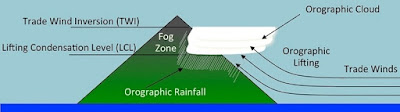 |
| Orographic Lifting of Trade Wind Air Source cited as requested: Giambelluca, T.W., Q. Chen, A.G. Frazier, J.P. Price, Y.-L. Chen, P.-S. Chu, J.K. Eischeid, and D.M. Delparte, 2013: Online Rainfall Atlas of Hawai‘i. Bull. Amer. Meteor. Soc. 94, 313-316, doi: 10.1175/BAMS-D-11-00228.1. |
Mauna Kea's summit atmosphere is extremely dry and disturbance and cloud-free for optimal celestial viewing. Astronomers from eleven countries have assembled a 2 billion dollar-collection of 13 of the world's largest observatories on the summit for optical, infrared and sub-millimeter astronomy. Recently, there has been strong local opposition by Native Hawaiian, environmental and cultural groups to another observatory planned (a $1.3 billion Thirty Meter telescope, ten times more powerful than the Hubble) and an Army helicopter landing zone for high altitude training to be built on Mauna Kea and Mauna Loa's sacred summits.
| Image may be NSFW. Clik here to view.  |
| The twin W.M. Keck Observatory domes atop Mauna Kea are among the largest optical telescopes in use with 33-foot primary mirrors. |
SWAYING PALMS, POUNDING SURF, TURQUOISE WATERS AND MILES OF SAND
The prominent tongue of lava (below) originated from vents along the flanks of Kohala volcano and continues well beyond the water's edge. This region of the Kohala Coast is fronted by offshore fringing reefs and numerous pocket sandy beaches. A paucity of
sediment-carrying perennial streams have conferred the west side with the cleanest and clearest water. Because of its clarity and the island's geological youth, it has the most live coral of the islands (57% or 29 sq. mi.).
Terrigenous sediment run-off and deposition on reefs significantly affect their health by blocking light and inhibiting photosynthesis, smothering and abrading the coral, and triggering macro-algae growth. In Hawaiian mythology, corals were the first creature that came into being before any higher forms emerged. Their importance is also ecological and recreational. Warm, calm and clear waters have made fishing, snorkeling and scuba diving a multi-million dollar industry (~$385 million in 2002).
| Image may be NSFW. Clik here to view.  |
| A dirt road cuts across a large platform of lava and connects remote and pristine Mahai'ula and Makalawena Beaches. |
WHITE, RED, GREEN AND BLACK SAND BEACHES
The varied colors of Hawai'i's beaches convey the geological story of the islands. Coral reefs flourish along older more stable, volcanically-quiescent coasts on the Big Island and the older islands of the chain progressing to the north, where water is sediment-clear and shallow to the sun.
Atoll formation was described as early as 1836 in the writings of Charles Darwin about the islands of Tahiti. As the Hawaiian islands age, erode and subside beneath the sea, they provide an environment for the formation of an encircling-ring of coral. Waves that pound offshore reefs and pulverize shells on the seafloor provide beaches with a steady supply of fine-grained, beige to yellowish calcareous sand. The small cobbles and smooth pebbles of black vesicular lava pleasantly clink underfoot while strolling on the beach.
| Image may be NSFW. Clik here to view.  |
| Along this section of the Kohala Coast (below), beach composition is slightly more volcanically than biologically-derived but is clearly a mix of vesicular basalt cobbles and pebbles, pulverized bivalves abd fragmented reef material. The island of Hawaii has 428 miles of coastline but less actual beaches than the other islands in the Hawaiian chain because of its geological youth. |
Over time, surf and currents erode fresh beds of volcanic ash and separate their component minerals by chemical erosion and mechanical action into greenish grains of olivine from lighter grains of black pyroxene by their differential densities. Besides green and black sand beaches, red sand beaches form on somewhat older shores via streams that carry black basalt and red oxidized cinder to the coast.
FLOWS OF LAVA TO THE SEA AND BEYOND
The thick bench of lava beyond the palms traveled some 35 miles from vents on the flanks of distant Mauna Loa in 1859. In the haze, the sloping west flank of Kohala is far to the right. With the exception of infrequent tsunamis, this side of the island is protected from large waves by its shape and the direction of prevailing ocean currents from the northeast. But it's not immune, as indicated by buried sediments containing seafloor coral fragments, mollusk shells and outer shelf deposits indicative of ancient inland surges.
| Image may be NSFW. Clik here to view.  |
| A dramatic pyroxene-rich black sand beach lies at pristine and isolated Kiholo Bay on the Kohalo Coast. The lava in the foreground emanated from Haulalai in 1800-1801, while the thick bench of lava was derived from Mauna Kai in 1859. The flow partially destroyed the historic site of a tidal fishpond built by King Kamehameha the Great in 1820. It was two miles in circumference with rocks walls 6 feet and and 20 feet wide. With turquoise waters, a serene lagoon, swaying palms, green sea turtles and humpback whales offshore, this area is one of the island's best kept secrets. |
Distant earthquakes and seafloor volcanic eruptions have and will continue to generate massive, fast-travelling walls of water. Even local flank landslides can displace water that "comes back" as a tsunamis. In a period of 157 years, a damaging or destructive tsunamis struck the islands every 12 years on average. All coastal regions post evacuation routes and have warning sirens that direct everyone to higher ground if a tsunami landfall is imminent.
Hilo is the Big Island's largest city and the tsunami capital of the world, facilitated by its funnel-shaped bay. It was devastated in 1946 (by a 7.8 magnitude earthquake near the Aleutian Islands) and 1960 (from a 9.5 magnitude quake off the coast of Chile). It's also the only city in the U.S. threatened by a lava flow (from Mauna Loa in in 1984).
| Image may be NSFW. Clik here to view.  |
| The population of the Hawaiian green sea turtle or honu, despite an overall declining trend globally, is increasing in abundance but is endangered nonetheless. Their lifespan is thought to be around 60-70 years and reach 200 pounds or more at maturity. They mate and nest in the Northwestern Hawaiian Islands chain and swim to the coastal areas of the main Hawaiian Islands to feed. Many are tagged with transponders on their flippers to track their behavior. |
TOUCHDOWN IMMINENT
Seconds from Kona Airport, I caught a glimpse of Hualalai at 8,275 feet shrouded in haze (below). The summit possessed a caldera, which has been obliterated by cinder and spatter cones typical of the volcano's late stage of eruption. Directly facing the viewer and largely in mist is Hualalai's Northwest Rift Zone with cinder and spatter cones along with faults, cracks and grabens from extension. It's one of three fissures that typically radiate from the flanks of Hawaiian basaltic volcanoes. Formed as the edifice settles under its own weight, the rift facilitates the lateral extrusion of lava rather than having to build sufficient pressure for a summit eruption, which also occurs.
Hualalai emerged from the sea prior to 300,000 years and is considered potentially dangerous, having erupted in 1801. In fact, the airport and neighboring coastal communities are built on the recent and underlying flows from 1,500 to 3,000 years ago. South of the airport begins the Kona Coast in the heart of the leeward side of the island in the rainshadow of Hualalai, Mauna Kea and Mauna Loa, which further insulate the coast from moisture-bearing winds.
| Image may be NSFW. Clik here to view.  |
| East-facing view of the summit of Kohala and the patchwork of interbedded lava flows that have emanated from flank vents as recent as 1801. Highway 19 (from left to right) encircles the island along with Highway 11 in the south. The island's third main road is Highway 130 or Saddle Road that slices through the lofty saddle from west to east between Mauna Kea and Mauna Loa. |
What I thought was atmospheric haze turned out to be vog, an odorless mix of volcanic gases, largely sulfur dioxide and water vapor carried some 35 miles by the wind from distant Kilauea to the south. The entire island is monitored for air quality by the state, and health advisories are issued if a plume of gas reaches dangerous levels. Persistent plumes generated by Halema'uma'u pit crater at Kilauea and its cinder cone Pu'u 'O'o have resulted in the closure of some roads in Volcanoes National Park.
TROUBLE IN PARADISE
Clumps of straw-colored fountain grass provide a striking color-contrast on the overlapping patchwork of pre-historic reddish-brown and relatively fresh, black lava flows that blanket Hualalai, but its unwanted. Introduced by man in the 1920's from Africa as an ornamental plant and still sold in nurseries, its has "escaped" to wilderness areas such as Hawai'i but also Arizona, Nevada and California. It's an invasive species that outcompetes indigenous plants for water and space in pasture lands and is a fire threat.
The story of fountain grass typifies Hawaii's ongoing struggle to prevent the introduction of non-indigenous species, prevent the extinction of indigenous species and reverse the island's declining biodiversity. Prior to human intervention, Hawaii's geographical isolation and varied topography have been the source of evolution and adaptation amongst the lifeforms that have reached the islands via the wind, ocean currents and attached to migratory birds. Unique birds and plants became perfectly suited to its environment and highly dependent on a fragile ecological balance to survive.
With the arrival of man, both intentional and accidental introduction of new species have upset that balance. The rate at which new species is introduced is estimated to be 2 million times more rapid than the natural rate. Thus, it is more crucial than ever that invasive, unwanted species be kept off the island, which accounts for the rigorous screening we experienced at the airport, even on domestic arrivals. Volcanoes National Park on the Big Island is a highly protected environment of preservation.
| Image may be NSFW. Clik here to view.  |
| Facing northwest from Highway 19, Kiholo Bay, Park and lagoon are nestled in the embayment. The lava in this section of the Kohala Coast are a mix of superficial flows from both Hualalai (1800-1801) and in the distance from Mauna Loa (1859). Older Mauna Loa flows between 1,500 and 10,000 years are underlying. |
Another non-indigenous example is the weasel-like Asian mongoose, introduced to sugar plantations in 1872 to control the destructive rat population that likely arrived on Polynesian canoes and later on European and American sailing vessels. Unfortunately, mongoose are diurnal and rats are nocturnal. They both have no natural predators in Hawaii and subsequently have overrun the island. I was amazed to spot a mongoose in downtown Hilo at noon scurrying across the main street between cars. Unfortunately, both have a taste for the eggs and hatchlings of native birds and endangered sea turtles. They also carry leptospirosis and other disease-producing bacteria in their droppings, which has entered some freshwater streams. And so it goes.
STAY TUNED FOR POST PART II AND MY GEO-HELI-TOUR OF THE BIG ISLAND
The Hawaiian Island chain inspired the theory of hotspots and mantle plumes. The ease of access and frequency of volcanic activity on the island of Hawai'i have established it as a type locality for basaltic volcanism; however much is still unclear and unknown such as the fundamentals of how Hawaiian volcanoes actually work, the structure of the mantle and the functionality of thermal plumes, if they really exist.
In posts Part II-IV, I'll cover my geo-heli-tour of the island of Hawaii and many of the details of what is known and what is sought after. Here's a sample of a video I took of a vegetated cinder cone as we climbed into the lofty Humuʻula Saddle between Mauna Kea and Mauna Loa. That's Mauna Loa in the distance.
Aloha!
RECOMMENDED PRINTED SOURCES OF INFORMATION ON THE HAWAIIAN ISLANDS
This rather lengthy list includes material on Pacific plate tectonics, hotspots, mantle plumes, theories on melting anomalies, mantle dynamics, Hawaiian glaciation, and basalt geochemistry and geophysics. The scientific articles, special papers, books, field trip guides and maps were used as reference information in the writing of this post. Have fun!
• A Brief History of the Plume Hypothesis and its Competitors: Concept and Controversy by Don L. Anderson and James Natland, GSA, Special Paper, 2005.
• A New Insight into the Hawaiian Plume by Jianshe Lei and Dapeng Zhao, Earth and Planetary Science Letters, 2006.
• A Possible Origin of the Hawaiian Islands by J. Tuzo Wilson, Canadian Journal of Physics 41, 1963.
• Archipelago - The Origin and Discovery of the Hawaiian Islands by Richard W. Grigg, 2014.
• Convection Plumes in the Lower Mantle by W.J. Morgan, Nature 230, 1971.
• Deep Mantle Convection Plumes and Plate Motions by W.J. Morgan, Bull. Am. Assoc. Pet. Geol. 56, 1972.
• Did the Atlantic Close and Then Reopen? by J. Tuzo Wilson, Nature, v. 211, 1966.
• Divergence Between Paleomagnetic and Hotspot Model Predicted Polar Wander for the Pacific Plate with Implications for Hotspot Fixity by William W. Sager, Texas A&M University, Revised Draft 23, 2006.
• Evidence From Islands on the Spreading of Ocean Floors by J. Tuzo Wilson, Nature Publishing Group 197, 1963.
• Explore the Geology of Kilauea Volcano by Richard Hazlett, 2014.
• Extensional Tectonics and Global Volcanism by J. Favela, Javier and D.L. Anderson, in Problems in Geophysics for the New Mellenium, 2000.
• Fast Paleogene Motion of the Pacific Hotspots from Revised Global Plate Circuit Constraints by C.A. Raymond et al, History and Dynamics of Plate Motions, edited by M.A. Richards, R.G. Gordon, and R.D. van der Hilst, pp. 359-375, 2000.
• Geologic Map of the State of Hawaii by David R. Sherrod, John M. Sinton, Sarah E. Watkins and Kelly M. Blunt, USGS, Open File Report 2007-1089.
• Hawaiian Volcanoes - From Source to Surface by Rebecca Carey et al, AGU, 2015.
• Hawaii Volcanoes National Park - Geologic Resources Inventory Report, NPS, 2009.
• Hawaiian Xenolith Populations , Magma Supply Rates and Development of Magma Chambers by D.A. Clague, Bulletin of Vulcanology, 1987.
• How Many Plumes Are There? by Bruce D. Malamud and Donald L. Turcotte, Earth and Planetary science Letters, 1999.
• Geochemistry of Lavas from the Emperor Seamounts, and the Geochemical Evolution Hawaiian Magmatism from 85 to 42 Ma by M. Regelous et al, Journal of Petrology, Vol. 44, 2003.
• Geology of Hawaii - Hofstra University Field Trip Guidebook by Charles Merguerian and Steven Okulewicz, 2007.
• Hotspots and Melting Anomalies by Garrett Ito and Peter E. van Keken, Treatise on Geophysics, 2015.
• Illustrated Geological Guide to the Island of Hawaii by Richard C. Robinson, 2010.
• Is Hotspot Volcanism a Consequence of Plate Tectonics? by G.R.Foulger and J.H. Natland, Science, Vol. 300, 2003.
• New Evidence for the Hawaiian Hotspot Plume Motion Since the Eocene by Josep M. Pares and Ted C. Moore, Earth and Planetary Science Letters, 2005.
• Oceanic Island Basalts and Mantle Plumes: The Geochemical Perspective by William M. White, Department of Earth and Atmospheric Sciences, Cornell University, Reviews in Advance, 2010.
• On the Motion of Hawaii and other Mantle Plumes by John A. Tarduno, Chemical Geology, 2007.
• Plate Tectonics by Wolfgang Frisch, Martin Meschede and Ronald Blakey, 2011.
• Plates vs Plumes - a Geological Controversy by G.R. Foulger, Wiley-Blackwell, 2010.
• Pleistocene Snowlines and Glaciation of the Hawaiian Islands by Stephen C. Porter, Department of Earth and Space Sciences, 2005.
• Plumes, or Plate Tectonic Processes by G.R. Foulger, Astronomy and Geophysics 43, 2002.
• Revision of Paleogene Plate Motions in the Pacific and Implications for the Hawaiian-Emperor Bend by Nicky M. Wright, GSA, Geology, 2014.
• Roadside Geology of Hawai'i by Richard W. Hazlett and Donald W. Hyndman, Mountain Press Publishing Company, 1966.
• Superplumes or Plume Clusters by G. Schubert et al, Physics of the Earth and Planetary Science Interiors, 2004.
• The Hawaiian-Emperor Volcanic Chain. Part I. Geologic Evolution by D.A. Clague and G.B. Dalrymple, Volcanism in Hawaii, Geological Survey Professional Paper 1350, 1987.
• The Mantle Plume Debate in Undergraduate Geoscience Education: Pverview, History and Recommendations by Brennan T. Jordan, Department of Earth Sciences, University of South Dakota, in Mantleplume.org.
• The Plate Model for the Genesis of Melting Anomalies by Gillian R. Foulger, Mantleplumes.org, 2006.
• Tectonics - Continental Drift and Mountain Building by Eldridge M. Moores and Robert J. Twiss, University of California at Davis, 1995.
• The Plate Model for the Genesis of Melting Anomalies - Chapter 1 by G.R. Foulger, GSA, 2007.
• Three Distinct Types of Hotspots in the Earth's Mantle by Vincent Courtillot et al, Earth and Planetary Science Letters 205, 2003.
• Through Thick and Thin by Neil M. Riber, Nature, Vol. 427, Barberry 2004.
NOTEWORTHY REFERENCES ON THE WEB
There's a ton of stuff on the web, but somehow I always ended up at these sites.
• The Hawaiian Plume Project: http://igppweb.ucsd.edu/~gabi/plume.html
• The USGS Hawaiian Sites: http://search.usa.gov/search?affiliate=usgs&utf8=%E2%9C%93&query=hawaii&commit=Search
• Mantle Plumes from the Platist's perspective: http://www.mantleplumes.org
• National Park Service site: http://www.nps.gov/havo/index.htm
• USGS Hawaiian Volcano Observatory: http://hvo.wr.usgs.gov
• On Wayne Ranney's blog, his well photo-documented field excursions always make you feel like you are right there: http://earthly-musings.blogspot.com/2011/06/hawaiian-geology-at-haleakala-crater.html and http://earthly-musings.blogspot.com/2011/06/trip-around-island-of-oahu.html